Bu fayl "Vikimedia Commons"dadır və digər layihələrdə istifadə edilə bilər.
Faylın təsvir səhifəsinə get
Xülasə
İzahLaptev Sea map.png
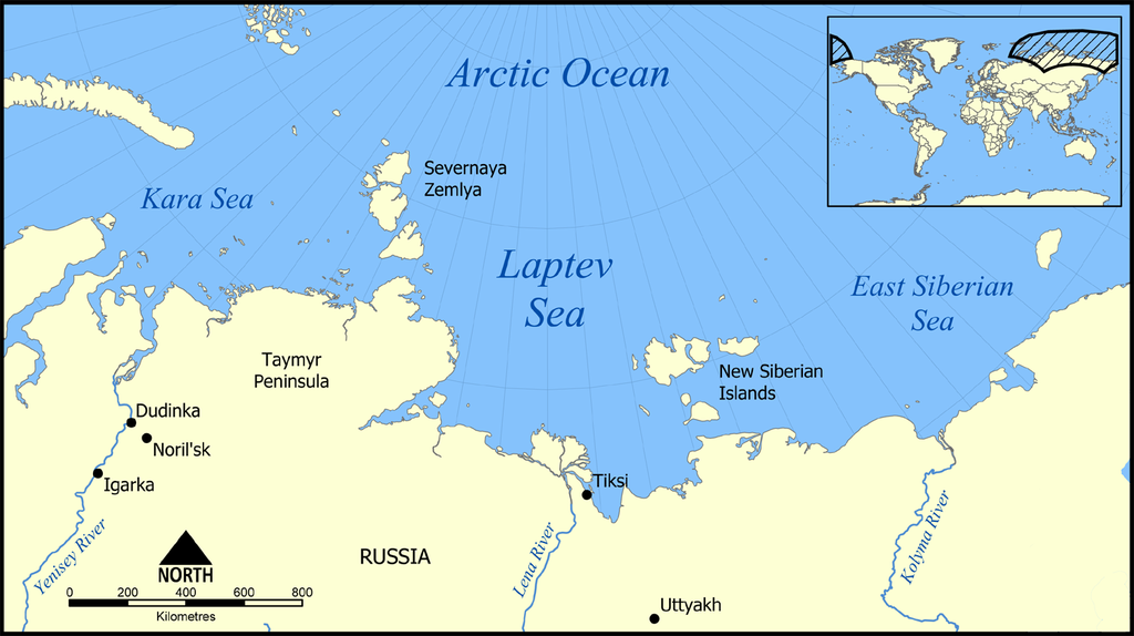
English: Location of the Laptev Sea north of Siberia, Russia. The sea is part of the Arctic Ocean, and neighbours the Kara Sea and East Siberian Sea.
Tarix
Mənbə
Öz işi
Müəllif
NormanEinstein
This locator map image could be re-created using vector graphics as an SVG file. This has several advantages; see Commons:Media for cleanup for more information. If an SVG form of this image is available, please upload it and afterwards replace this template with {{vector version available|new image name}}. It is recommended to name the SVG file "Laptev Sea map.svg" – then the template Vector version available (or Vva) does not need the new image name parameter.
Lisenziya
I, the copyright holder of this work, hereby publish it under the following licenses:
Bu sənədi GNU Azad Sənədləşdirmə Lisenziyası, Versiya 1.2 və ya Azad Proqram Fondu tərəfindən nəşr olunan hər hansı sonrakı versiya şərtlərinə əsasən dəyişməz bölmələr, ön qapaq mətnləri və arxa qapaq mətnləri olmadan köçürmək, yayımlamaq və / və ya dəyişdirmək üçün icazə verilir; Lisenziyanın bir nüsxəsi GNU Azad Sənədləşdirmə Lisenziyası adlı hissəyə daxil edilmişdir.http://www.gnu.org/copyleft/fdl.htmlGFDLGNU Free Documentation Licensetruetrue
Bu fayl Creative Commons Attribution-Share Alike 3.0 Sinqapur lisenziyası altında yayımlanır.
Azadsınız:
paylaşmaq – əsəri köçürmək, paylamaq və ötürmək üçün
remiks etmək – əsəri adaptasiya etmək
Aşağıdakı şərtlərə riayət etməklə:
istinad – Müvafiq kredit verməlisiniz, lisenziyaya bir keçid verməlisiniz və dəyişikliklərin olub olmadığını bildirməlisiniz. Bunu hər hansı bir ağlabatan şəkildə edə bilərsiniz, ancaq lisenziyalaşdırıcının sizi və ya istifadənizi təsdiqləməsini təklif edən bir şəkildə deyil.
bənzər paylaşma – Əsəri remix edirsinizsə, dəyişdirirsinizsə və ya üzərində iş aparırsınızsa, öz töhfələrinizi orijinalda olduğu kimi eyni və ya uyğun lisenziya altında yayımlamalısınız.
This licensing tag was added to this file as part of the GFDL licensing update.http://creativecommons.org/licenses/by-sa/3.0/CC BY-SA 3.0Creative Commons Attribution-Share Alike 3.0truetrue
This map shows the location of the Laptev Sea north of Siberia, Russia. The sea is part of the Arctic Ocean, and neighbours the Kara Sea and East Siberian Sea. Created by NormanEinstein, December 5, 2005. {{GFDL-self}} Category:Maps of seas
fayl, laptev, fayl, faylın, tarixçəsi, fayl, keçidləri, faylın, qlobal, istifadəsisınaq, göstərişi, ölçüsü, piksel, digər, ölçülər, piksel, piksel, piksel, piksel, faylın, orijinalı, 8206, piksel, fayl, həcmi, mime, növü, image, fayl, vikimedia, commons, dadır. Fayl Faylin tarixcesi Fayl kecidleri Faylin qlobal istifadesiSinaq gosterisi olcusu 800 449 piksel Diger olculer 320 179 piksel 640 359 piksel 1 024 574 piksel 1 500 841 piksel Faylin orijinali 8206 1 500 841 piksel fayl hecmi 382 KB MIME novu image png Bu fayl Vikimedia Commons dadirve diger layihelerde istifade edile biler Faylin tesvir sehifesine get Xulase IzahLaptev Sea map png English Location of the Laptev Sea north of Siberia Russia The sea is part of the Arctic Ocean and neighbours the Kara Sea and East Siberian Sea Tarix 5 dekabr 2005 Menbe Oz isi Muellif NormanEinstein This locator map image could be re created using vector graphics as an SVG file This has several advantages see nbsp Commons Media for cleanup for more information If nbsp an nbsp SVG nbsp form nbsp of nbsp this nbsp image is available please upload it and afterwards replace this template with vector version available i new image name i It is recommended to name the SVG file Laptev Sea map svg then the template Vector version available or Vva does not need the new image name parameter Lisenziya I the copyright holder of this work hereby publish it under the following licenses Bu senedi GNU Azad Senedlesdirme Lisenziyasi Versiya 1 2 ve ya Azad Proqram Fondu terefinden nesr olunan her hansi sonraki versiya sertlerine esasen deyismez bolmeler on qapaq metnleri ve arxa qapaq metnleri olmadan kocurmek yayimlamaq ve ve ya deyisdirmek ucun icaze verilir Lisenziyanin bir nusxesi GNU Azad Senedlesdirme Lisenziyasi adli hisseye daxil edilmisdir http www gnu org copyleft fdl html GFDL GNU Free Documentation License true true Bu fayl Creative Commons Attribution Share Alike 3 0 Sinqapur lisenziyasi altinda yayimlanir Azadsiniz paylasmaq eseri kocurmek paylamaq ve oturmek ucun remiks etmek eseri adaptasiya etmek Asagidaki sertlere riayet etmekle istinad Muvafiq kredit vermelisiniz lisenziyaya bir kecid vermelisiniz ve deyisikliklerin olub olmadigini bildirmelisiniz Bunu her hansi bir aglabatan sekilde ede bilersiniz ancaq lisenziyalasdiricinin sizi ve ya istifadenizi tesdiqlemesini teklif eden bir sekilde deyil benzer paylasma Eseri remix edirsinizse deyisdirirsinizse ve ya uzerinde is aparirsinizsa oz tohfelerinizi orijinalda oldugu kimi eyni ve ya uygun lisenziya altinda yayimlamalisiniz This licensing tag was added to this file as part of the GFDL licensing update http creativecommons org licenses by sa 3 0 CC BY SA 3 0 Creative Commons Attribution Share Alike 3 0 true trueIstediyiniz lisenziyani sece bilersiniz Derivative works Derivative works of this file Laptev Sea map Morze Laptiewow polish version pl png Laptev Sea map sv png Laptev Sea map hr svg Laptev Sea map hu svgCaptionsazerbaycancaAdd a one line explanation of what this file representsingilisLocation of the Laptev Sea north of Siberia Russia Items portrayed in this filetesvir edirLaptevler denizicopyright status nbsp ingiliscopyrighted nbsp ingilislisenziyaGNU Free Documentation License version 1 2 or later nbsp ingilisCreative Commons Attribution ShareAlike 3 0 Unported nbsp ingilissource of file nbsp ingilisoriginal creation by uploader nbsp ingilisyaranma tarixi5 dekabr 2005 Faylin tarixcesi Faylin evvelki versiyasini gormek ucun gun tarix bolmesindeki tarixlere klikleyin Tarix VaxtKicik sekilOlculerIstifadeciSerh indiki21 23 27 fevral 20161 500 841 382 KB JahoeClean up png coding stripped off large chunks of irrelevant metadata left behind by adobe editor Image itself unaltered 14 10 23 mart 20151 500 841 434 KB RokerHROoptipng o7 i0 25 66 decrease 21 42 5 dekabr 20051 500 841 583 KB NormanEinsteinThis map shows the location of the Laptev Sea north of Siberia Russia The sea is part of the Arctic Ocean and neighbours the Kara Sea and East Siberian Sea Created by NormanEinstein December 5 2005 GFDL self Category Maps of seas Fayl kecidleri Bu sekile olan kecidler Laptevler denizi Ribniy yarimadasi Taymir yarimadasi Istifadeci muzakiresi Araz Yaquboglu Arxiv 10 Istifadeci muzakiresi Qizilbas Istifadeci muzakiresi Resid Nurmemmedov Istifadeci muzakiresi Sortilegus Arxiv 2019 Vikipediya Heftenin yaxsi meqalesi 18 Hefte 2019 Vikipediya Heftenin yaxsi meqalesi may 2019 Faylin qlobal istifadesi Bu fayl asagidaki vikilerde istifade olunur af wikipedia org layihesinde istifadesi Laptefsee ar wikipedia org layihesinde istifadesi تايميار azb wikipedia org layihesinde istifadesi لاپتو دنیزی be tarask wikipedia org layihesinde istifadesi Tajmyr bn wikipedia org layihesinde istifadesi ল প ত ভ স গর br wikipedia org layihesinde istifadesi Mor Laptev bs wikipedia org layihesinde istifadesi Laptevsko more ca wikipedia org layihesinde istifadesi Peninsula de Taimir Ivan Papanin cs wikipedia org layihesinde istifadesi Tajmyr poloostrov More Laptevu cy wikipedia org layihesinde istifadesi Mor Laptev da wikipedia org layihesinde istifadesi 2 Kamtjatka ekspedition de wikipedia org layihesinde istifadesi Taimyrhalbinsel Laptewsee Iwan Dmitrijewitsch Papanin Zweite Kamtschatkaexpedition Igarka el wikipedia org layihesinde istifadesi Gewgrafia ths Rwsias en wikipedia org layihesinde istifadesi Geography of Russia Laptev Sea Taymyr Peninsula User NormanEinstein gallery Operation Wunderland Russian Arctic islands Fishing industry in Russia List of Russian explorers Taimyr Central Siberian tundra Wikipedia Graphics Lab Map workshop Archive Apr 2020 en wiktionary org layihesinde istifadesi Laptev Sea eo wikipedia org layihesinde istifadesi Duoninsulo Tajmir Lapteva maro eu wikipedia org layihesinde istifadesi Laptev Taimyr penintsula fa wikipedia org layihesinde istifadesi دریای لاپتف شبه جزیره تایمیر جزایر شمالگانی روسیه frr wikipedia org layihesinde istifadesi Taimyr fr wikipedia org layihesinde istifadesi Wikipedia Atelier graphique Cartes Archives Demandes mises en sommeil Monde Utilisateur Skiff A illustrer Iles de l Arctique russe fy wikipedia org layihesinde istifadesi Laptevsee gl wikipedia org layihesinde istifadesi Mar de Laptev he wikipedia org layihesinde istifadesi ויקיפדיה איך להקים אסם תבניות מידע בערכים מפה מצוירת מיועדת להחלפה במפה דינמית ק ת ויקיפדיה סדנה לגרפיקה ארכיון 34 חצי האי טיימיר hi wikipedia org layihesinde istifadesi ल पत व स गर त म र प र यद व प hr wikipedia org layihesinde istifadesi Tajmir poluotok hu wiktionary org layihesinde istifadesi Laptyev tenger Bu faylin qlobal istifadesine baxin Menbe https az wikipedia org wiki Fayl Laptev Sea map png, wikipedia, oxu, kitab, kitabxana, axtar, tap, hersey,
ne axtarsan burda
, en yaxsi meqale sayti, meqaleler, kitablar, oyrenmek, wiki, bilgi, tarix, seks, porno, indir, yukle, sex, azeri sex, azeri, seks yukle, sex yukle, izle, seks izle, porno izle, mobil seks, telefon ucun, chat, azeri chat, tanisliq, tanishliq, azeri tanishliq, sayt, medeni, medeni saytlar, chatlar, mekan, tanisliq mekani, mekanlari, yüklə, pulsuz, pulsuz yüklə, mp3, video, mp4, 3gp, jpg, jpeg, gif, png, şəkil, muisiqi, mahnı, kino, film, kitab, oyun, oyunlar.