Bu fayl "Vikimedia Commons"dadır və digər layihələrdə istifadə edilə bilər.
Faylın təsvir səhifəsinə get
Xülasə
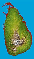
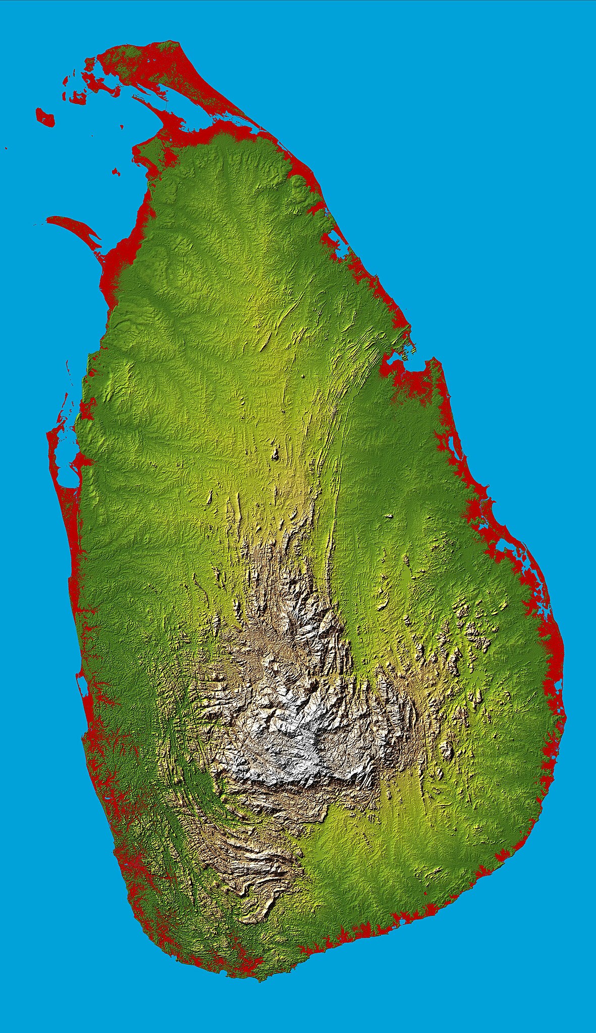
İzahTopography Sri Lanka.jpg
English: Topography of Sri Lanka, obtained from the Shuttle Radar Topography Mission of STS-99, aboard the Space Shuttle Endeavour. Heights below 10 meters (33 feet) above sea level have been colored red.
Bu faylda fotoaparat və ya skanerlə əlavə olunmuş məlumatlar var. Əgər fayl sonradan redaktə olunubsa, bəzi parametrlər bu şəkildə göstərilənlərdən fərqli ola bilər.
_error
0
İyun 15, 2023
fayl, topography, lanka, fayl, faylın, tarixçəsi, fayl, keçidləri, faylın, qlobal, istifadəsi, metaməlumatlarsınaq, göstərişi, ölçüsü, piksel, digər, ölçülər, piksel, piksel, piksel, piksel, piksel, piksel, faylın, orijinalı, 8206, piksel, fayl, həcmi, mime, n. Fayl Faylin tarixcesi Fayl kecidleri Faylin qlobal istifadesi MetamelumatlarSinaq gosterisi olcusu 346 600 piksel Diger olculer 138 240 piksel 277 480 piksel 443 768 piksel 591 1 024 piksel 1 181 2 048 piksel 3 000 5 200 piksel Faylin orijinali 8206 3 000 5 200 piksel fayl hecmi 3 27 MB MIME novu image jpeg Bu fayl Vikimedia Commons dadirve diger layihelerde istifade edile biler Faylin tesvir sehifesine get Xulase IzahTopography Sri Lanka jpg English Topography of Sri Lanka obtained from the Shuttle Radar Topography Mission of STS 99 aboard the Space Shuttle Endeavour Heights below 10 meters 33 feet above sea level have been colored red Tarix fevral 2000 Menbe http photojournal jpl nasa gov catalog PIA06670 Muellif National Aeronautics amp Space Administration Object location7 nbsp 00 nbsp 00 nbsp N 80 nbsp 40 nbsp 00 nbsp E nbsp View this and other nearby images on OpenStreetMap7 000000 80 666667 Lisenziya Public domain Public domain false false This file is in the public domain in the United States because it was solely created by NASA NASA copyright policy states that NASA material is not protected by copyright unless noted See Template PD USGov NASA copyright policy page or JPL Image Use Policy Warnings Use of NASA logos insignia and emblems is restricted per U S law 14 CFR 1221 The NASA website hosts a large number of images from the Soviet Russian space agency and other non American space agencies These are not necessarily in the public domain Materials based on Hubble Space Telescope data may be copyrighted if they are not explicitly produced by the STScI 1 See also PD Hubble and Cc Hubble The SOHO ESA amp NASA joint project implies that all materials created by its probe are copyrighted and require permission for commercial non educational use 2 Images featured on the Astronomy Picture of the Day APOD web site may be copyrighted 3 The National Space Science Data Center NSSDC site has been known to host copyrighted content Its photo gallery FAQ states that all of the images in the photo gallery are in the public domain Unless otherwise noted CaptionsazerbaycancaAdd a one line explanation of what this file representsfarsتوپوگرافی سریلانکا به دست آمده از ماموریت توپوگرافی رادار شاتل STS 99 در شاتل فضایی Endeavour Items portrayed in this filetesvir ediryaranma tarixifevral 2000coordinates of depicted place nbsp ingilis7 0 0 000 N 80 40 0 001 E Faylin tarixcesi Faylin evvelki versiyasini gormek ucun gun tarix bolmesindeki tarixlere klikleyin Tarix VaxtKicik sekilOlculerIstifadeciSerh indiki17 43 27 mart 20053 000 5 200 3 27 MB FEXX PD USGov NASA Fayl kecidleri Bu sekile olan kecidler Sri Lanka adasi Sri Lanka cografiyasi Faylin qlobal istifadesi Bu fayl asagidaki vikilerde istifade olunur af wikipedia org layihesinde istifadesi Sri Lanka ar wikipedia org layihesinde istifadesi سريلانكا arz wikipedia org layihesinde istifadesi سريلانكا ast wikipedia org layihesinde istifadesi Sri Lanka bcl wikipedia org layihesinde istifadesi Sri Lanka be wikipedia org layihesinde istifadesi Shry Lanka Shry Lanka vostray bg wikipedia org layihesinde istifadesi Shri Lanka Geografiya na Shri Lanka bg wiktionary org layihesinde istifadesi Shri Lanka Sri Lanka bn wikipedia org layihesinde istifadesi প রব শদ ব র স র ক ন র ব চ ত ম নচ ত র প রব শদ ব র স র ক ন র ব চ ত ম নচ ত র ১ শ র লঙ ক র র পর খ ca wikipedia org layihesinde istifadesi Sri Lanka ceb wikipedia org layihesinde istifadesi Sri Lanka pulo de wikipedia org layihesinde istifadesi 22 Mai Benutzer FEXX Galerie2 Sri Lanka Benutzer Uwe Dedering Landerliste Benutzer Horas 22 Mai Ostgondwana de wikivoyage org layihesinde istifadesi Welterbe in Sri Lanka diq wikipedia org layihesinde istifadesi Sri Lanka el wikipedia org layihesinde istifadesi Sri Lanka en wikipedia org layihesinde istifadesi Sri Lanka Geography of Sri Lanka Portal Sri Lanka User Trengarasu User Deavenger Outline of Sri Lanka User RitigalaJayasena UserBoxes EquitySriLanka User ProudIrishAspie User Djodjo666 User Blackknight12 sandbox Wikipedia Graphics Lab Map workshop Archive Dec 2015 User JFoog Wikipedia Userboxes Politics by country Sri Lanka en wikiversity org layihesinde istifadesi Comparative law and justice Sri Lanka eo wikipedia org layihesinde istifadesi Srilanko es wikipedia org layihesinde istifadesi Sri Lanka Geografia de Sri Lanka et wikipedia org layihesinde istifadesi Sri Lanka saar fa wikipedia org layihesinde istifadesi سری لانکا جغرافیای سری لانکا fi wikipedia org layihesinde istifadesi Sri Lankan maantiede fr wikipedia org layihesinde istifadesi Geographie du Sri Lanka Projet Cartographie Cartes standards Pays Massif central Sri Lanka Environnement au Sri Lanka Bu faylin qlobal istifadesine baxin Metamelumatlar Bu faylda fotoaparat ve ya skanerle elave olunmus melumatlar var Eger fayl sonradan redakte olunubsa bezi parametrler bu sekilde gosterilenlerden ferqli ola biler error0 Menbe https az wikipedia org wiki Fayl Topography Sri Lanka jpg, wikipedia, oxu, kitab, kitabxana, axtar, tap, hersey,
ne axtarsan burda
, en yaxsi meqale sayti, meqaleler, kitablar, oyrenmek, wiki, bilgi, tarix, seks, porno, indir, yukle, sex, azeri sex, azeri, seks yukle, sex yukle, izle, seks izle, porno izle, mobil seks, telefon ucun, chat, azeri chat, tanisliq, tanishliq, azeri tanishliq, sayt, medeni, medeni saytlar, chatlar, mekan, tanisliq mekani, mekanlari, yüklə, pulsuz, pulsuz yüklə, mp3, video, mp4, 3gp, jpg, jpeg, gif, png, şəkil, muisiqi, mahnı, kino, film, kitab, oyun, oyunlar.