Bu fayl "Vikimedia Commons"dadır və digər layihələrdə istifadə edilə bilər.
Faylın təsvir səhifəsinə get
Xülasə
Warning
The original file is very high-resolution. It might not load properly or could cause your browser to freeze when opened at full size. To avoid these issues, use the ZoomViewer.
العربية: خريطة ڤالدسيمولير العائدة لِسنة 1507م. هذه الخريطة هي الأولى التي أوردت اسم «أمريكا» وأوَّل خريطة فصلت الأمريكتين عن آسيا. هذه النسخة هي الوحيدة الباقية، وقد اشترتها مكتبة الكونغرس سنة 2001م مُقابل 10 ملايين دولار أمريكي.
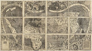
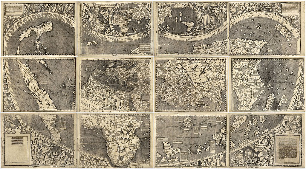
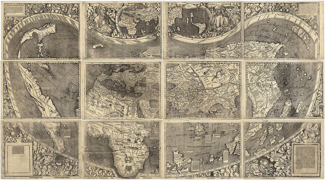
English: Waldseemüller map from 1507 is the first map to include the name "America" and the first to depict the Americas as separate from Asia. There is only one surviving copy of the map, which was purchased by the Library of Congress in 2001 for $10 million.
Français : Le planisphère de Waldseemüller de 1507 est la première carte mentionnant le nom "America" et la première à décrire les Amériques séparées de l'Asie. Il ne reste plus qu'une seule copie du planisphère encore existante à ce jour, acquise par la bibliothèque du Congrès en 2001 pour la somme de 10 millions de dollars.
xəritəşünas, cosmographer, ilahiyyatçı və coğrafiyaşünas
Doğum/ölüm tarixi
circa 1470
date QS:P,+1470-00-00T00:00:00Z/9,P1480,Q5727902
16 mart 1520
Doğum/ölüm yeri
Wolfenweiler bei Freiburg im Breisgau
Sen-Dye-de-Voj
Yaradıcılıq illəri
1500
Normativ yoxlama
: Q57197
VIAF: 27366067
ISNI: 0000 0001 2100 1609
ULAN: 500478549
Open Library: OL1451558A
LCCN: n90601547
WorldCat
creator QS:P170,Q57197
Digər versiyalar
This file has an extracted image: File:TERRA·VLTERIꝰ·INCOGNITA.jpg.
100% quality
81% quality
Composite
This is a featured picture on Wikimedia Commons (Featured pictures) and is considered one of the finest images. This is a Valued image and is considered to meet the Valued image criteria.
Vikipediya
This is a featured picture on the ərəb language Wikipedia (صور مختارة) and is considered one of the finest images. This is a featured picture on the ingilis language Wikipedia (Featured pictures) and is considered one of the finest images. This is a featured picture on the türk language Wikipedia (Seçkin resimler) and is considered one of the finest images.
If you have an image of similar quality that can be published under a suitable copyright license, be sure to upload it, tag it, and nominate it.
Lisenziya
Public domainPublic domainfalsefalse
https://creativecommons.org/publicdomain/mark/1.0/PDMCreative Commons Public Domain Mark 1.0falsefalse
Captions
Add a one-line explanation of what this file represents
Planisphère de Waldseemüller datant de 1507.
Items portrayed in this file
təsvir edir
Waldseemüller map ingilis
Commons quality assessment ingilis
Wikimedia Commons featured picture ingilis
Faylın tarixçəsi
Faylın əvvəlki versiyasını görmək üçün gün/tarix bölməsindəki tarixlərə klikləyin.
{{Information |Description={{en|1=waldseemuller map, full page from http://memory.loc.gov/cgi-bin/map_item.pl?data=/home/www/data/gmd/gmd3/g3200/g3200/ct000725.jp2&style=gmd&itemLink=r?ammem/gmd:@field(NUMBER+@band(g3200+ct000725))&title=Universalis%20cos
fayl, waldseemuller, fayl, faylın, tarixçəsi, istifadə, edilən, səhifələr, faylın, qlobal, istifadəsisınaq, göstərişi, ölçüsü, piksel, digər, ölçülər, piksel, piksel, piksel, piksel, piksel, piksel, faylın, orijinalı, 8206, piksel, fayl, həcmi, mime, növü, ima. Fayl Faylin tarixcesi Istifade edilen sehifeler Faylin qlobal istifadesiSinaq gosterisi olcusu 800 443 piksel Diger olculer 320 177 piksel 640 354 piksel 1 024 567 piksel 1 280 709 piksel 2 560 1 417 piksel 13 708 7 590 piksel Faylin orijinali 8206 13 708 7 590 piksel fayl hecmi 19 65 MB MIME novu image jpeg Bu fayl Vikimedia Commons dadirve diger layihelerde istifade edile biler Faylin tesvir sehifesine get Xulase Warning The original file is very high resolution It might not load properly or could cause your browser to freeze when opened at full size To avoid these issues use the ZoomViewer Open in ZoomViewerIzahWaldseemuller map 2 jpg العربية خريطة ڤالدسيمولير العائدة ل سنة 1507م هذه الخريطة هي الأولى التي أوردت اسم أمريكا وأو ل خريطة فصلت الأمريكتين عن آسيا هذه النسخة هي الوحيدة الباقية وقد اشترتها مكتبة الكونغرس سنة 2001م م قابل 10 ملايين دولار أمريكي English Waldseemuller map from 1507 is the first map to include the name America and the first to depict the Americas as separate from Asia There is only one surviving copy of the map which was purchased by the Library of Congress in 2001 for 10 million Francais Le planisphere de Waldseemuller de 1507 est la premiere carte mentionnant le nom America et la premiere a decrire les Ameriques separees de l Asie Il ne reste plus qu une seule copie du planisphere encore existante a ce jour acquise par la bibliotheque du Congres en 2001 pour la somme de 10 millions de dollars Tarix 1507Menbe https www loc gov resource g3200 ct000725Muellif Martin Waldseemuller 1470 1520 Alternativ adlar Martin HylacomylusIzah xeritesunas cosmographer ilahiyyatci ve cografiyasunasDogum olum tarixi circa 1470 date QS P 1470 00 00T00 00 00Z 9 P1480 Q572790216 mart 1520 Dogum olum yeri Wolfenweiler bei Freiburg im BreisgauSen Dye de VojYaradiciliq illeri 1500 Normativ yoxlama Q57197 VIAF 27366067 ISNI 0000 0001 2100 1609 ULAN 500478549 Open Library OL1451558A LCCN n90601547 WorldCat creator QS P170 Q57197Diger versiyalar This file has an extracted image File TERRA VLTERIꝰ INCOGNITA jpg 100 quality 81 quality Composite This is a featured picture on Wikimedia Commons Featured pictures and is considered one of the finest images This is a Valued image and is considered to meet the Valued image criteria Vikipediya This is a featured picture on the ereb language Wikipedia صور مختارة and is considered one of the finest images This is a featured picture on the ingilis language Wikipedia Featured pictures and is considered one of the finest images This is a featured picture on the turk language Wikipedia Seckin resimler and is considered one of the finest images If you have an image of similar quality that can be published under a suitable copyright license be sure to upload it tag it and nominate it Lisenziya Public domain Public domain false falseThis work is in the public domain in its country of origin and other countries and areas where the copyright term is the author s life plus 100 years or fewer This work is in the public domain in the United States because it was published or registered with the U S Copyright Office before January 1 1928 This file has been identified as being free of known restrictions under copyright law including all related and neighboring rights https creativecommons org publicdomain mark 1 0 PDM Creative Commons Public Domain Mark 1 0 false falseCaptionsazerbaycancaAdd a one line explanation of what this file representsfransizPlanisphere de Waldseemuller datant de 1507 Items portrayed in this filetesvir edirWaldseemuller map ingilisCommons quality assessment ingilisWikimedia Commons featured picture ingilis Faylin tarixcesi Faylin evvelki versiyasini gormek ucun gun tarix bolmesindeki tarixlere klikleyin Tarix VaxtKicik sekilOlculerIstifadeciSerh indiki17 37 27 oktyabr 200813 708 7 590 19 65 MB Jackaranga Information Description en 1 waldseemuller map full page from http memory loc gov cgi bin map item pl data home www data gmd gmd3 g3200 g3200 ct000725 jp2 amp style gmd amp itemLink r ammem gmd field NUMBER band g3200 ct000725 amp title Universalis 20cos Istifade edilen sehifeler Bu sekile olan kecidler Amerika toponim Faylin qlobal istifadesi Bu fayl asagidaki vikilerde istifade olunur af wikipedia org layihesinde istifadesi Wikipedia Beeld van die week 2019 Wikipedia Voorbladbeeld week 5 2019 als wikipedia org layihesinde istifadesi Departement Vosges ar wikipedia org layihesinde istifadesi الأمريكتان العصر الحديث خريطة فالدسيمولير استكشاف أمريكا الشمالية بوابة جغرافيا صورة مختارة أرشيف ويكيبيديا صور مختارة رسومات وجداول وخرائط خرائط ويكيبيديا ترشيحات الصور المختارة خريطة فالدسيمولير ويكيبيديا صورة اليوم المختارة مارس 2018 قالب صورة اليوم المختارة 2018 03 24 بوابة جغرافيا صورة مختارة 13 ويكيبيديا صورة اليوم المختارة سبتمبر 2022 قالب صورة اليوم المختارة 2022 09 03 ast wikipedia org layihesinde istifadesi Continente bg wikipedia org layihesinde istifadesi Martin Valdzeemyuler bn wikipedia org layihesinde istifadesi প রশ ন ত মহ স গর ca wikipedia org layihesinde istifadesi Continent Martin Waldseemuller Usuari Mcapdevila Mapa de Waldseemuller Cosmographiae introductio Universalis Cosmographia cs wikipedia org layihesinde istifadesi Wikipedie Obrazek tydne 2009 Portal Geografie Zajimavosti tydne Archiv Waldseemullerova mapa Portal Geografie Zajimavosti tydne 2009 52 Wikipedie Obrazek tydne 2009 51 Portal Geografie Zajimavosti tydne 2009 53 cy wikipedia org layihesinde istifadesi Martin Waldseemuller da wikipedia org layihesinde istifadesi Waldseemullerkortet Amerikas navngivning de wikipedia org layihesinde istifadesi 16 Jahrhundert Christoph Kolumbus Neuzeit Martin Waldseemuller Weltkarte Benutzer Mondamo karten Liste historischer Weltkarten UNESCO Kultur und Naturerbe Benutzer GiFontenelle Entwurf Q131454 bibliothek Benutzer Muhali Waldseemuller Karte el wikipedia org layihesinde istifadesi Hpeiroi en wikipedia org layihesinde istifadesi Martin Waldseemuller Pacific Ocean Maximilian I Holy Roman Emperor Naming of the Americas Early modern period Cosmographiae Introductio History of geography Bu faylin qlobal istifadesine baxin Menbe https az wikipedia org wiki Fayl Waldseemuller map 2 jpg, wikipedia, oxu, kitab, kitabxana, axtar, tap, hersey,
ne axtarsan burda
, en yaxsi meqale sayti, meqaleler, kitablar, oyrenmek, wiki, bilgi, tarix, seks, porno, indir, yukle, sex, azeri sex, azeri, seks yukle, sex yukle, izle, seks izle, porno izle, mobil seks, telefon ucun, chat, azeri chat, tanisliq, tanishliq, azeri tanishliq, sayt, medeni, medeni saytlar, chatlar, mekan, tanisliq mekani, mekanlari, yüklə, pulsuz, pulsuz yüklə, mp3, video, mp4, 3gp, jpg, jpeg, gif, png, şəkil, muisiqi, mahnı, kino, film, kitab, oyun, oyunlar.