Bu fayl "Vikimedia Commons"dadır və digər layihələrdə istifadə edilə bilər.
Faylın təsvir səhifəsinə get
iThe source code of this SVG is valid.
İzahUnibicameral Map.svg
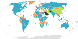
Map of the legislative organizations of the countries of the world, originally by Aris Katsaris. Note: This only shows national legislatures, federations with sublegislatures are not required to have sublegislatures on the same model as their country: The United States has a bicameral legislature, the State of Nebraska has a unicameral legislature. Similarly, although Canada has a bicameral legislature, all of its provinces and territories have unicameral legislatures. Note: Any official "legislature", including unelected and powerlessly limited ones, are counted. Countries without a functioning legislature, such as countries governed by a military junta, are coloured black.
English (en): Map of nations based on their legislatures.
Nations with a unicameral form of legislature.
Nations with a unicameral legislature and an advisory body.
Nations with a bicameral form of legislature.
Nations with no form of legislature.
Data not available.
العربية (ar): خريطة الدول بناءً على برلماناتها.
دول لديها برلمان بغرفة واحدة.
دول لديها برلمان من مجلسين.
دول ليس لديها برلمان.
البيانات غير متوفرة.
فارسی (fa): نقشهٔ نهادهای قانونگذار جهان بر پایهٔ نظام مجلس
نهاد قانونگذاری تکمجلسی
نهاد قانونگذاری دومجلسی
نهاد قانونگذاری تکمجلسی و یک نهاد مشورتی
بی مجلس
بی داده
русский (Ru): Законодательная власть.
Однопалатные парламенты.
Однопалатные парламенты с консультативным органом.
Двухпалатные парламенты.
Парламент отсутствует.
Нет данных.
Deutsch (de): Staaten und ihre Legislative.
Staaten mit Einkammersystem.
Staaten mit Einkammersystem und Beratungsorgan.
Staaten mit Zweikammersystem.
Staaten ohne Legislative.
Ohne Daten.
français (fr): Une carte des pays basée sur leurs systèmes parlementaires.
Pays avec un parlement monocaméral.
Pays avec un parlement bicaméral.
Pays sans forme de parlement.
Données non disponibles.
македонски (mk): Карта на државите според видот на законодавниот дом.
Држави со еднодомно собрание.
Држави со дводомно собрание.
Држави без формален законодавен дом.
Нема податоци.
Nederlands (nl): Kaart met landen gebaseerd op hun parlementssysteem.
Landen met een eenkamerstelsel.
Landen met een eenkamerstelsel en een adviesorgaan.
Landen with a tweekamerstelsel.
Landen zonder vorm van parlement.
Gegevens niet beschikbaar.
español (es): Mapa de naciones basado en legislaciones.
Naciones con legislación unicameral.
Naciones con legislación unicameral y un consejo consultivo.
Naciones con legislación bicameral.
Naciones sin ninguna forma de legislación.
Informacion no disponible.
italiano (it): Mappa dei sistemi parlamentari nel mondo.
Nazioni con parlamento unicamerale.
Nazioni con parlamento bicamerale.
Nazioni senza parlamento.
Dati non disponibili.
dansk (da): Kort over verdens lande baseret på deres parlamenter.
Nationer med et etkammersystem.
Nationer med et tokammersystem.
Nationer uden et parlament.
Intet data tilgængeligt.
magyar (hu): Világtérkép az államok törvényhozása szerint
Államok egykamarás törvényhozással
Államok kétkamarás törvényhozással
Államok törvényhozási forma nélkül
nincs adat
català (ca): Mapa d'estats segons llurs òrgans legislatius.
Estats monocamerals.
Estats monocamerals que compten amb un òrgan consultiu.
Estats bicamerals.
Estats sense òrgan legislatiu.
Sense dades.
Türkçe (tr): Milletlerin yasama organlarına göre haritası.
Tek meclisli sisteme sahip devletler.
Tek meclisli bir sistem ve bir danışma organı olan devletler.
Çift meclisli sisteme sahip devletler.
Yasama organı olmayan devletler.
Verisiz.
Bu sənədi GNU Azad Sənədləşdirmə Lisenziyası, Versiya 1.2 və ya Azad Proqram Fondu tərəfindən nəşr olunan hər hansı sonrakı versiya şərtlərinə əsasən dəyişməz bölmələr, ön qapaq mətnləri və arxa qapaq mətnləri olmadan köçürmək, yayımlamaq və / və ya dəyişdirmək üçün icazə verilir; Lisenziyanın bir nüsxəsi GNU Azad Sənədləşdirmə Lisenziyası adlı hissəyə daxil edilmişdir.http://www.gnu.org/copyleft/fdl.htmlGFDLGNU Free Documentation Licensetruetrue
Bu fayl Creative Commons Attribution-Share Alike 3.0 Sinqapur lisenziyası altında yayımlanır.
Azadsınız:
paylaşmaq – əsəri köçürmək, paylamaq və ötürmək üçün
remiks etmək – əsəri adaptasiya etmək
Aşağıdakı şərtlərə riayət etməklə:
istinad – Müvafiq kredit verməlisiniz, lisenziyaya bir keçid verməlisiniz və dəyişikliklərin olub olmadığını bildirməlisiniz. Bunu hər hansı bir ağlabatan şəkildə edə bilərsiniz, ancaq lisenziyalaşdırıcının sizi və ya istifadənizi təsdiqləməsini təklif edən bir şəkildə deyil.
bənzər paylaşma – Əsəri remix edirsinizsə, dəyişdirirsinizsə və ya üzərində iş aparırsınızsa, öz töhfələrinizi orijinalda olduğu kimi eyni və ya uyğun lisenziya altında yayımlamalısınız.
This licensing tag was added to this file as part of the GFDL licensing update.http://creativecommons.org/licenses/by-sa/3.0/CC-BY-SA-3.0Creative Commons Attribution-Share Alike 3.0truetrue
Orijinal yükləmə gündəliyi
This image is a derivative work of the following images:
File:Unibicameral_Map.png licensed with GFDL-en, GFDL-user-en-note
2007-06-19T16:31:05Z Gadren 1262x628 (46103 Bytes) == Summary == Map of unicameral and bicameral parliaments around the world. Created by [[:en:User:Aris Katsaris|Aris Katsaris]]. Orange is for unicameral, blue is for bicameral and gray is neither. == Licensing == {{GFDL-use
2007-05-05T18:17:47Z Gadren 1262x628 (46144 Bytes) Map of unicameral and bicameral parliaments around the world. Created by [[:en:User:Aris Katsaris|Aris Katsaris]]. Orange is for unicameral, blue is for bicameral and gray is neither.
2006-04-23T21:37:14Z Metarhyme 1262x628 (46084 Bytes) == Summary == Map of unicameral and bicameral parliaments around the world. Created by [[:en:User:Aris Katsaris|Aris Katsaris]]. Orange is for unicameral, blue is for bicameral and gray is neither. == Licensing == {{GFDL-use
2005-11-11T21:57:05Z Moyogo 1262x628 (27224 Bytes) fixed DR Congo
2005-10-06T07:06:09Z Gabbe 1262x628 (27124 Bytes) Fix Kalimantan
2005-10-05T21:10:43Z Gabbe 1262x628 (27137 Bytes) fixed Indonesia
2005-10-04T07:03:25Z Gabbe 1262x628 (27151 Bytes) Map of unicameral and bicameral parliaments around the world. Created by [[:en:User:Aris Katsaris|Aris Katsaris]].
2005-09-05T06:04:29Z Gabbe 1262x628 (27060 Bytes) Map of unicameral and bicameral parliaments around the world. Created by [[en:User:Aris Katsaris|]].
File:BlankMap-World6.svg licensed with PD-self
2009-06-13T16:59:33Z NuclearVacuum 940x477 (1671030 Bytes) fixed the global outline on my upload
2009-06-13T16:55:42Z NuclearVacuum 940x477 (1671080 Bytes) Similar to how Serbia and Kosovo are separated, I made the outline for Abkhazia, South Ossetia, and Transnistria
2009-03-20T01:00:21Z AzaToth 940x477 (1605234 Bytes) Fix errorious duplicate end tag of id='ma'/> Specified style, dc:format, and dc:title tag to be CDATA
2009-03-19T23:57:36Z AzaToth 940x477 (1605207 Bytes) Fix duplicate ID (was two "mf", changed second to "mf-")
2009-01-23T13:36:09Z Yug 940x477 (1605206 Bytes) The English colours are controversial: ink consuming, not print friendly [black&white], CIA based.
2009-01-19T18:37:07Z Emilfaro 940x477 (1605212 Bytes) CSS edited to bring in accordance with [[:en:Wikipedia:WikiProject Maps]] Standard convention on the Map colors.
2008-11-02T02:13:36Z Lokal Profil 940x477 (1605206 Bytes) Reverted to version as of 00:30, 29 March 2008. This version includes metadata about title and license of image. The SVG validator is broken with regards to metadata (and other thing) see [[:Template talk:ValidSVG]] for more
2008-03-29T00:30:24Z Canuckguy 940x477 (1605206 Bytes) fixed error found: Sao Tome (code "st") was messing with the coast tag ("coast" ends in "st") on some maps. Changed "land", "coast", "circle" and "sub" tags to "landxx", "coastxx", "circlexx" and "subxx" to prevent further
2008-02-27T21:20:02Z Canuckguy 940x477 (1602296 Bytes) make borders touch, add circles for French DOMs and Chinese SARs, undo rounding of numbers, delete some extraneous nodes.
2008-02-02T18:38:58Z AzaToth 940x477 (881503 Bytes) rounding the values to near whole numbers. I don't think the decimals will do any visible difference at all.
2007-12-14T02:57:29Z Lokal Profil 940x477 (1616830 Bytes) a class fix to France. Moved the france group further down to not cover andorra circle etc. Got rid of som translate tags by recalculating the paths.
2007-12-09T20:27:34Z Canuckguy 940x477 (1616719 Bytes) thinner line for borders
2007-12-09T03:58:49Z Canuckguy 940x477 (1616984 Bytes) changes to France (see description and discussion pages), added a class for islands without an international border that makes the coastline thinner
2007-11-08T22:20:44Z Ketiltrout 940x477 (1614834 Bytes) Move Disko Island and the Bahamas back to their rightful places
2007-09-25T02:52:30Z Canuckguy 940x477 (1631712 Bytes) Moved css classes around and added a few additional instructions in the css for colouring the map. Fixed a few errors that were reverted.
2007-09-17T22:06:35Z Lokal Profil 940x477 (1632888 Bytes) aq_land (and arctic) to aq, removed two formating cludges which didn't make any visual difference, Replaced swaziland by formating cludge around swaziland and renamed, removed duplicat "ki" entry (probably left by me last tim
2007-09-13T18:52:32Z Lokal Profil 940x477 (1635420 Bytes) Basically same edits as Canuckguy but in a text editor so as to eliminate Inksacape junk code and preserve the style structure. Also made sure all circles are above the surrounding countries.
2007-09-10T05:54:39Z Canuckguy 940x477 (1915635 Bytes) Simplified circles - now in same layer as countries (making the whole file one layer), simplified a few other things as detailed on the changes in the descrption on the talk page.
2007-09-09T03:03:49Z Lokal Profil 940x477 (1632593 Bytes) Added ISO-id to Mongolia, Bhutan and Andorra circle, Corrected id of Malawi, made "Swaziland border path" transparent so that colour of underlying path becomes visible. Also removed Inkscape objects, cleaned out a lot of blan
2007-08-29T21:14:30Z H2g2bob 940x477 (1630393 Bytes) Remove class="..." from elements if parent has same or similar class, allowing for inheritance of style rules.
2007-08-25T22:15:44Z H2g2bob 940x477 (1686400 Bytes) Update to map to include styles in CSS stylesheet using <svg:style> tags. This allows changing the style of the entire map in one go. This edit was done in a text editor.
2007-08-22T00:27:08Z Canuckguy 940x477 (2019787 Bytes) fixed a few problems with previous version (restored small countries circles, fixed problem with Germany and Serbia)
2007-07-08T21:00:39Z Andrew pmk 940x477 (2021488 Bytes) Remove lots of small islands which are not visible or barely visible at normal zoom levels; clean up borders so that boundaries are included in the main country groups, rather than being separate objects; make background all
2007-07-04T00:04:59Z AzaToth 940x477 (2265956 Bytes) Minor optimizations using perl SVG::Parser and SVG modules (reparsing the tree)
2007-01-09T03:38:38Z Roke 940x477 (2370958 Bytes) Reverted to earlier revision
2007-01-09T03:37:25Z Roke 940x477 (2549763 Bytes) hidden layers: separate non-sovereign & sovereign circles, text
2006-12-10T10:34:46Z Brianski 940x477 (2209317 Bytes) re-optimized with optisvg.pl
2006-11-26T06:54:55Z Canuckguy 940x477 (2370957 Bytes) deleted Aksai Chin, awarded territory to China (nation of control, as India is pictured as the nation of control over Arunchal Pradesh). Revised from previous version by me, so may need optimizing by Brianski's tool again (s
2006-11-23T11:27:06Z Brianski 940x477 (2273821 Bytes) optimized using Brian Szymanski's optisvg.pl
2006-11-21T23:09:04Z Canuckguy 940x477 (2440482 Bytes) a few more minor tweaks
2006-11-12T04:13:48Z Hexagon1 940x477 (2365940 Bytes) Canuckguy's fixed some errors
2006-11-12T02:02:50Z Hexagon1 940x765 (2318315 Bytes) Detailed SVG map with grouping enabled to connect all non-contiguous parts of a country's territory for easy colouring.
Uploaded with derivativeFX
Captions
Add a one-line explanation of what this file represents
پاکستان
Mapa d'estats segons llurs òrgans legislatius.
Items portrayed in this file
təsvir edir
copyright status ingilis
copyrighted ingilis
lisenziya
GNU Free Documentation License, version 1.2 or later ingilis
Creative Commons Attribution-ShareAlike 3.0 Unported ingilis
MIME type ingilis
image/svg+xml
Faylın tarixçəsi
Faylın əvvəlki versiyasını görmək üçün gün/tarix bölməsindəki tarixlərə klikləyin.
(ən yeni | ən əvvəlki) Göstər (10 daha yeni) (10 daha köhnə) (10 | 20 | 50 | 100 | 250 | 500).
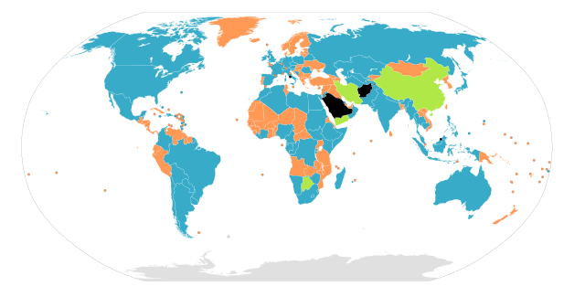
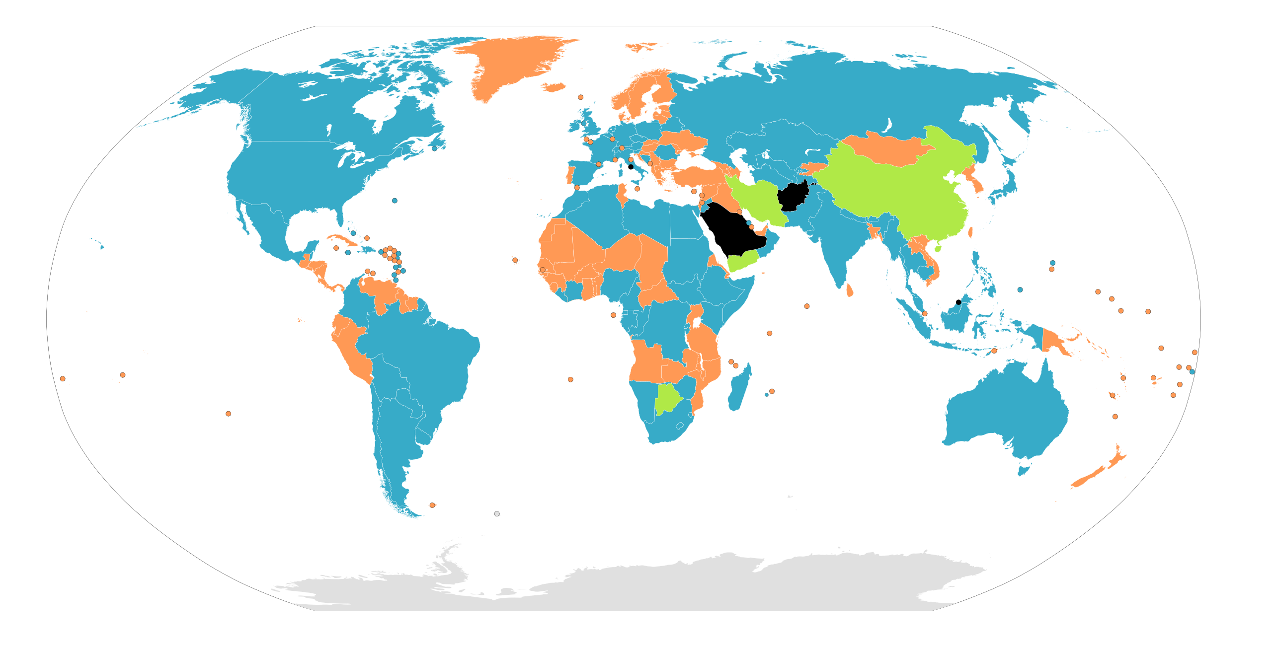
China is a nation with an unicameral legislature and an advisory body.(see Chinese People's Political Consultative Conference & National People's Congress) HK and Macao are literally Special Administrative Regions (SAR, provincial-level) under Beijing, whose legislatures are not national.(see 2017 National People's Congress election in Hong Kong)
Botswana is not unambiguously Bicameral and Iran is not unambiguously Unicameral. Both the Iranian Assembly of Experts and the Motswana House of Chiefs are advisory bodies to the Parliament that are ambiguously upper houses.
Bu faylda fotoaparat və ya skanerlə əlavə olunmuş məlumatlar var. Əgər fayl sonradan redaktə olunubsa, bəzi parametrlər bu şəkildə göstərilənlərdən fərqli ola bilər.
Genişlik
939.74725
Hündürlük
476.7276
Yanvar 05, 2023
fayl, unibicameral, fayl, faylın, tarixçəsi, istifadə, edilən, səhifələr, faylın, qlobal, istifadəsi, metaməlumatlarbu, faylın, formatındakı, görünüşünün, ölçüsü, piksel, digər, ölçülər, piksel, piksel, piksel, piksel, piksel, piksel, faylın, orijinalı, 8206, . Fayl Faylin tarixcesi Istifade edilen sehifeler Faylin qlobal istifadesi MetamelumatlarBu SVG faylin PNG formatindaki bu gorunusunun olcusu 800 406 piksel Diger olculer 320 162 piksel 640 325 piksel 1 024 520 piksel 1 280 650 piksel 2 560 1 299 piksel 940 477 piksel Faylin orijinali 8206 SVG fayli nominal olaraq 940 477 piksel faylin olcusu 1 64 MB Bu fayl Vikimedia Commons dadirve diger layihelerde istifade edile biler Faylin tesvir sehifesine get i The source code of this SVG is valid IzahUnibicameral Map svg Map of the legislative organizations of the countries of the world originally by Aris Katsaris Note This only shows national legislatures federations with sublegislatures are not required to have sublegislatures on the same model as their country The United States has a bicameral legislature the State of Nebraska has a unicameral legislature Similarly although Canada has a bicameral legislature all of its provinces and territories have unicameral legislatures Note Any official legislature including unelected and powerlessly limited ones are counted Countries without a functioning legislature such as countries governed by a military junta are coloured black Tarix 22 iyun 2009 11 39 UTC Menbe Unibicameral Map png BlankMap World6 svgMuellif Unibicameral Map png Aris Katsaris BlankMap World6 svg en User Canuckguy SkyBonTalkContributions derivative work Cerveaugenie Legend English en Map of nations based on their legislatures Nations with a unicameral form of legislature Nations with a unicameral legislature and an advisory body Nations with a bicameral form of legislature Nations with no form of legislature Data not available العربية ar خريطة الدول بناء على برلماناتها دول لديها برلمان بغرفة واحدة دول لديها برلمان من مجلسين دول ليس لديها برلمان البيانات غير متوفرة فارسی fa نقشه نهادهای قانون گذار جهان بر پایه نظام مجلس نهاد قانون گذاری تک مجلسی نهاد قانون گذاری دومجلسی نهاد قانون گذاری تک مجلسی و یک نهاد مشورتی بی مجلس بی داده russkij Ru Zakonodatelnaya vlast Odnopalatnye parlamenty Odnopalatnye parlamenty s konsultativnym organom Dvuhpalatnye parlamenty Parlament otsutstvuet Net dannyh Deutsch de Staaten und ihre Legislative Staaten mit Einkammersystem Staaten mit Einkammersystem und Beratungsorgan Staaten mit Zweikammersystem Staaten ohne Legislative Ohne Daten francais fr Une carte des pays basee sur leurs systemes parlementaires Pays avec un parlement monocameral Pays avec un parlement bicameral Pays sans forme de parlement Donnees non disponibles makedonski mk Karta na drzhavite spored vidot na zakonodavniot dom Drzhavi so ednodomno sobranie Drzhavi so dvodomno sobranie Drzhavi bez formalen zakonodaven dom Nema podatoci Nederlands nl Kaart met landen gebaseerd op hun parlementssysteem Landen met een eenkamerstelsel Landen met een eenkamerstelsel en een adviesorgaan Landen with a tweekamerstelsel Landen zonder vorm van parlement Gegevens niet beschikbaar espanol es Mapa de naciones basado en legislaciones Naciones con legislacion unicameral Naciones con legislacion unicameral y un consejo consultivo Naciones con legislacion bicameral Naciones sin ninguna forma de legislacion Informacion no disponible italiano it Mappa dei sistemi parlamentari nel mondo Nazioni con parlamento unicamerale Nazioni con parlamento bicamerale Nazioni senza parlamento Dati non disponibili dansk da Kort over verdens lande baseret pa deres parlamenter Nationer med et etkammersystem Nationer med et tokammersystem Nationer uden et parlament Intet data tilgaengeligt magyar hu Vilagterkep az allamok torvenyhozasa szerint Allamok egykamaras torvenyhozassal Allamok ketkamaras torvenyhozassal Allamok torvenyhozasi forma nelkul nincs adat catala ca Mapa d estats segons llurs organs legislatius Estats monocamerals Estats monocamerals que compten amb un organ consultiu Estats bicamerals Estats sense organ legislatiu Sense dades Turkce tr Milletlerin yasama organlarina gore haritasi Tek meclisli sisteme sahip devletler Tek meclisli bir sistem ve bir danisma organi olan devletler Cift meclisli sisteme sahip devletler Yasama organi olmayan devletler Verisiz Bu senedi GNU Azad Senedlesdirme Lisenziyasi Versiya 1 2 ve ya Azad Proqram Fondu terefinden nesr olunan her hansi sonraki versiya sertlerine esasen deyismez bolmeler on qapaq metnleri ve arxa qapaq metnleri olmadan kocurmek yayimlamaq ve ve ya deyisdirmek ucun icaze verilir Lisenziyanin bir nusxesi GNU Azad Senedlesdirme Lisenziyasi adli hisseye daxil edilmisdir http www gnu org copyleft fdl html GFDL GNU Free Documentation License true trueBu fayl Creative Commons Attribution Share Alike 3 0 Sinqapur lisenziyasi altinda yayimlanir Azadsiniz paylasmaq eseri kocurmek paylamaq ve oturmek ucun remiks etmek eseri adaptasiya etmek Asagidaki sertlere riayet etmekle istinad Muvafiq kredit vermelisiniz lisenziyaya bir kecid vermelisiniz ve deyisikliklerin olub olmadigini bildirmelisiniz Bunu her hansi bir aglabatan sekilde ede bilersiniz ancaq lisenziyalasdiricinin sizi ve ya istifadenizi tesdiqlemesini teklif eden bir sekilde deyil benzer paylasma Eseri remix edirsinizse deyisdirirsinizse ve ya uzerinde is aparirsinizsa oz tohfelerinizi orijinalda oldugu kimi eyni ve ya uygun lisenziya altinda yayimlamalisiniz This licensing tag was added to this file as part of the GFDL licensing update http creativecommons org licenses by sa 3 0 CC BY SA 3 0 Creative Commons Attribution Share Alike 3 0 true trueOrijinal yukleme gundeliyi This image is a derivative work of the following images File Unibicameral Map png licensed with GFDL en GFDL user en note 2009 06 08T11 46 57Z Middayexpress 1262x628 17539 Bytes updated 2009 06 08T11 45 29Z Middayexpress 1262x628 17539 Bytes Updated 2009 04 18T12 49 18Z SeNeKa 1262x628 17534 Bytes updated 2009 04 18T09 53 11Z SeNeKa 1262x628 16784 Bytes Updated 2007 06 19T16 31 05Z Gadren 1262x628 46103 Bytes Summary Map of unicameral and bicameral parliaments around the world Created by en User Aris Katsaris Aris Katsaris Orange is for unicameral blue is for bicameral and gray is neither Licensing GFDL use 2007 05 05T18 17 47Z Gadren 1262x628 46144 Bytes Map of unicameral and bicameral parliaments around the world Created by en User Aris Katsaris Aris Katsaris Orange is for unicameral blue is for bicameral and gray is neither 2006 06 22T22 13 33Z Nightstallion 1262x628 46090 Bytes slovenia s bicameral 2006 04 23T21 37 14Z Metarhyme 1262x628 46084 Bytes Summary Map of unicameral and bicameral parliaments around the world Created by en User Aris Katsaris Aris Katsaris Orange is for unicameral blue is for bicameral and gray is neither Licensing GFDL use 2006 02 13T06 02 50Z Jaranda 1262x628 46191 Bytes 2005 11 11T21 57 05Z Moyogo 1262x628 27224 Bytes fixed DR Congo 2005 10 06T07 06 09Z Gabbe 1262x628 27124 Bytes Fix Kalimantan 2005 10 05T21 10 43Z Gabbe 1262x628 27137 Bytes fixed Indonesia 2005 10 04T07 03 25Z Gabbe 1262x628 27151 Bytes Map of unicameral and bicameral parliaments around the world Created by en User Aris Katsaris Aris Katsaris 2005 09 05T06 04 29Z Gabbe 1262x628 27060 Bytes Map of unicameral and bicameral parliaments around the world Created by en User Aris Katsaris File BlankMap World6 svg licensed with PD self 2009 06 13T16 59 33Z NuclearVacuum 940x477 1671030 Bytes fixed the global outline on my upload 2009 06 13T16 55 42Z NuclearVacuum 940x477 1671080 Bytes Similar to how Serbia and Kosovo are separated I made the outline for Abkhazia South Ossetia and Transnistria 2009 05 13T13 58 14Z SkyBon 940x477 1601527 Bytes fixed 2009 05 13T03 24 33Z Unionhawk 940x477 1605234 Bytes Reverted to version as of 01 00 20 March 2009 2009 05 12T15 39 38Z SkyBon 940x477 1601502 Bytes oops 2009 05 12T15 38 35Z SkyBon 477x940 1601502 Bytes code cleanup 2009 03 20T01 00 21Z AzaToth 940x477 1605234 Bytes Fix errorious duplicate end tag of id ma gt Specified style dc format and dc title tag to be CDATA 2009 03 19T23 57 36Z AzaToth 940x477 1605207 Bytes Fix duplicate ID was two mf changed second to mf 2009 01 23T13 36 09Z Yug 940x477 1605206 Bytes The English colours are controversial ink consuming not print friendly black amp white CIA based 2009 01 19T18 37 07Z Emilfaro 940x477 1605212 Bytes CSS edited to bring in accordance with en Wikipedia WikiProject Maps Standard convention on the Map colors 2008 11 02T02 13 36Z Lokal Profil 940x477 1605206 Bytes Reverted to version as of 00 30 29 March 2008 This version includes metadata about title and license of image The SVG validator is broken with regards to metadata and other thing see Template talk ValidSVG for more 2008 11 02T01 32 33Z Victormoz 940x477 1601613 Bytes 2008 11 02T01 28 12Z Victormoz 940x477 1601629 Bytes 2008 11 02T01 14 36Z Victormoz 940x477 1601705 Bytes 2008 03 29T00 30 24Z Canuckguy 940x477 1605206 Bytes fixed error found Sao Tome code st was messing with the coast tag coast ends in st on some maps Changed land coast circle and sub tags to landxx coastxx circlexx and subxx to prevent further 2008 02 28T03 55 15Z Canuckguy 940x477 1604123 Bytes re added missing Honduras 2008 02 27T21 20 02Z Canuckguy 940x477 1602296 Bytes make borders touch add circles for French DOMs and Chinese SARs undo rounding of numbers delete some extraneous nodes 2008 02 02T18 38 58Z AzaToth 940x477 881503 Bytes rounding the values to near whole numbers I don t think the decimals will do any visible difference at all 2007 12 14T02 57 29Z Lokal Profil 940x477 1616830 Bytes a class fix to France Moved the france group further down to not cover andorra circle etc Got rid of som translate tags by recalculating the paths 2007 12 09T20 27 34Z Canuckguy 940x477 1616719 Bytes thinner line for borders 2007 12 09T03 58 49Z Canuckguy 940x477 1616984 Bytes changes to France see description and discussion pages added a class for islands without an international border that makes the coastline thinner 2007 11 08T22 20 44Z Ketiltrout 940x477 1614834 Bytes Move Disko Island and the Bahamas back to their rightful places 2007 10 06T20 29 38Z Canuckguy 940x477 1614582 Bytes removed unneeded classes 2007 09 25T02 52 30Z Canuckguy 940x477 1631712 Bytes Moved css classes around and added a few additional instructions in the css for colouring the map Fixed a few errors that were reverted 2007 09 17T22 06 35Z Lokal Profil 940x477 1632888 Bytes aq land and arctic to aq removed two formating cludges which didn t make any visual difference Replaced swaziland by formating cludge around swaziland and renamed removed duplicat ki entry probably left by me last tim 2007 09 13T18 52 32Z Lokal Profil 940x477 1635420 Bytes Basically same edits as Canuckguy but in a text editor so as to eliminate Inksacape junk code and preserve the style structure Also made sure all circles are above the surrounding countries 2007 09 10T05 54 39Z Canuckguy 940x477 1915635 Bytes Simplified circles now in same layer as countries making the whole file one layer simplified a few other things as detailed on the changes in the descrption on the talk page 2007 09 09T03 03 49Z Lokal Profil 940x477 1632593 Bytes Added ISO id to Mongolia Bhutan and Andorra circle Corrected id of Malawi made Swaziland border path transparent so that colour of underlying path becomes visible Also removed Inkscape objects cleaned out a lot of blan 2007 08 29T21 14 30Z H2g2bob 940x477 1630393 Bytes Remove class from elements if parent has same or similar class allowing for inheritance of style rules 2007 08 25T22 15 44Z H2g2bob 940x477 1686400 Bytes Update to map to include styles in CSS stylesheet using lt svg style gt tags This allows changing the style of the entire map in one go This edit was done in a text editor 2007 08 22T00 27 08Z Canuckguy 940x477 2019787 Bytes fixed a few problems with previous version restored small countries circles fixed problem with Germany and Serbia 2007 07 08T21 00 39Z Andrew pmk 940x477 2021488 Bytes Remove lots of small islands which are not visible or barely visible at normal zoom levels clean up borders so that boundaries are included in the main country groups rather than being separate objects make background all 2007 07 04T00 04 59Z AzaToth 940x477 2265956 Bytes Minor optimizations using perl SVG Parser and SVG modules reparsing the tree 2007 01 09T03 38 38Z Roke 940x477 2370958 Bytes Reverted to earlier revision 2007 01 09T03 37 25Z Roke 940x477 2549763 Bytes hidden layers separate non sovereign amp sovereign circles text 2006 12 29T04 02 15Z Canuckguy 940x477 2370958 Bytes 2006 12 10T10 34 46Z Brianski 940x477 2209317 Bytes re optimized with optisvg pl 2006 11 26T06 54 55Z Canuckguy 940x477 2370957 Bytes deleted Aksai Chin awarded territory to China nation of control as India is pictured as the nation of control over Arunchal Pradesh Revised from previous version by me so may need optimizing by Brianski s tool again s 2006 11 23T11 27 06Z Brianski 940x477 2273821 Bytes optimized using Brian Szymanski s optisvg pl 2006 11 21T23 09 04Z Canuckguy 940x477 2440482 Bytes a few more minor tweaks 2006 11 12T04 13 48Z Hexagon1 940x477 2365940 Bytes Canuckguy s fixed some errors 2006 11 12T02 02 50Z Hexagon1 940x765 2318315 Bytes Detailed SVG map with grouping enabled to connect all non contiguous parts of a country s territory for easy colouring Uploaded with derivativeFXCaptionsazerbaycancaAdd a one line explanation of what this file representsurduپاکستانkatalanMapa d estats segons llurs organs legislatius Items portrayed in this filetesvir edircopyright status ingiliscopyrighted ingilislisenziyaGNU Free Documentation License version 1 2 or later ingilisCreative Commons Attribution ShareAlike 3 0 Unported ingilisMIME type ingilisimage svg xml Faylin tarixcesi Faylin evvelki versiyasini gormek ucun gun tarix bolmesindeki tarixlere klikleyin en yeni en evvelki Goster 10 daha yeni 10 daha kohne 10 20 50 100 250 500 Tarix VaxtKicik sekilOlculerIstifadeciSerh indiki23 50 6 oktyabr 2022940 477 1 64 MB Duonautyemen has an advisory shura council 04 26 17 iyun 2022940 477 1 7 MB 25stargeneralUpdate Qatar and Afghanistan Both are quasi consultative but have real political power 09 26 11 dekabr 2021940 477 1 7 MB EyesnoreFixed Senegal 09 18 11 dekabr 2021940 477 1 7 MB EyesnoreEgypt is now bicameral Mauritania is now unicameral Turkmenistan is now bicameral 17 57 2 iyun 2020940 477 1 7 MB CatOnMarsChina is a nation with an unicameral legislature and an advisory body see Chinese People 039 s Political Consultative Conference amp National People 039 s Congress HK and Macao are literally Special Administrative Regions SAR provincial level under Beijing whose legislatures are not national see 2017 National People 039 s Congress election in Hong Kong 14 46 17 may 2019940 477 1 71 MB Mapache del RatonCote d 039 Ivoire is bicameral since 2016 Senegal is no longer bicameral since 2012 and Cameroon is now bicameral since 2013 07 52 27 avqust 2017940 477 1 69 MB Glide08Botswana is not unambiguously Bicameral and Iran is not unambiguously Unicameral Both the Iranian Assembly of Experts and the Motswana House of Chiefs are advisory bodies to the Parliament that are ambiguously upper houses 13 01 8 mart 2017940 477 1 69 MB TubezlobLybia bicameral 10 59 23 fevral 2016940 477 1 69 MB Augusta 89L Egypte est devenu monocameral 19 07 26 avqust 2015940 477 1 69 MB FlappiefhAdded South Sudan Kenya Burundi and Rwanda are bicameral en yeni en evvelki Goster 10 daha yeni 10 daha kohne 10 20 50 100 250 500 Istifade edilen sehifeler Bu sekile olan kecidler Bir palatali parlament Parlament Iki palatali parlament Faylin qlobal istifadesi Bu fayl asagidaki vikilerde istifade olunur af wikipedia org layihesinde istifadesi Parlement ar wikipedia org layihesinde istifadesi برلمان من مجلسين برلمان بغرفة واحدة ast wikipedia org layihesinde istifadesi Bicameralismu as wikipedia org layihesinde istifadesi একসদনব দ be wikipedia org layihesinde istifadesi Parlament Zakanadaychaya ylada Dvuhpalatny parlament Adnapalatny parlament bg wikipedia org layihesinde istifadesi Ednokamaren parlament bs wikipedia org layihesinde istifadesi Jednodomni sistem Dvodomni sistem ca wikipedia org layihesinde istifadesi Bicameralitat Monocameralitat cs wikipedia org layihesinde istifadesi Bikameralismus cy wikipedia org layihesinde istifadesi Unsiambraeth Dwysiambraeth de wikipedia org layihesinde istifadesi Zweikammersystem Einkammersystem Dreikammersystem diq wikipedia org layihesinde istifadesi Parlamento el wikipedia org layihesinde istifadesi Koinoboyleytikh dhmokratia Koinoboylio Monokameralismos en wikipedia org layihesinde istifadesi Parliament Bicameralism Unicameralism Multicameralism en wikivoyage org layihesinde istifadesi Legislative buildings es wikipedia org layihesinde istifadesi Poder legislativo Bicameralidad Unicameralidad et wikipedia org layihesinde istifadesi Parlament eu wikipedia org layihesinde istifadesi Ganbera bitasun fa wikipedia org layihesinde istifadesi مجلس دومجلسی fi wikipedia org layihesinde istifadesi Kaksikamarijarjestelma Yksikamarijarjestelma fr wikipedia org layihesinde istifadesi Bicamerisme Monocamerisme Regime parlementaire Wikipedia Atelier graphique Cartes Archives janvier 2010 Wikipedia Atelier graphique Cartes Archives aout 2015 Wikipedia Atelier graphique Cartes Archives fevrier 2016 Wikipedia Atelier graphique Images a ameliorer Archives Mars 2017 fr wiktionary org layihesinde istifadesi monocamerisme bicamerisme hi wikipedia org layihesinde istifadesi एकसदनव द द व सदनपद धत hu wikipedia org layihesinde istifadesi Parlament Bu faylin qlobal istifadesine baxin Metamelumatlar Bu faylda fotoaparat ve ya skanerle elave olunmus melumatlar var Eger fayl sonradan redakte olunubsa bezi parametrler bu sekilde gosterilenlerden ferqli ola biler Genislik939 74725Hundurluk476 7276 Menbe https az wikipedia org wiki Fayl Unibicameral Map svg, wikipedia, oxu, kitab, kitabxana, axtar, tap, hersey,
ne axtarsan burda
, en yaxsi meqale sayti, meqaleler, kitablar, oyrenmek, wiki, bilgi, tarix, seks, porno, indir, yukle, sex, azeri sex, azeri, seks yukle, sex yukle, izle, seks izle, porno izle, mobil seks, telefon ucun, chat, azeri chat, tanisliq, tanishliq, azeri tanishliq, sayt, medeni, medeni saytlar, chatlar, mekan, tanisliq mekani, mekanlari, yüklə, pulsuz, pulsuz yüklə, mp3, video, mp4, 3gp, jpg, jpeg, gif, png, şəkil, muisiqi, mahnı, kino, film, kitab, oyun, oyunlar.