Bu fayl "Vikimedia Commons"dadır və digər layihələrdə istifadə edilə bilər.
Faylın təsvir səhifəsinə get
Xülasə
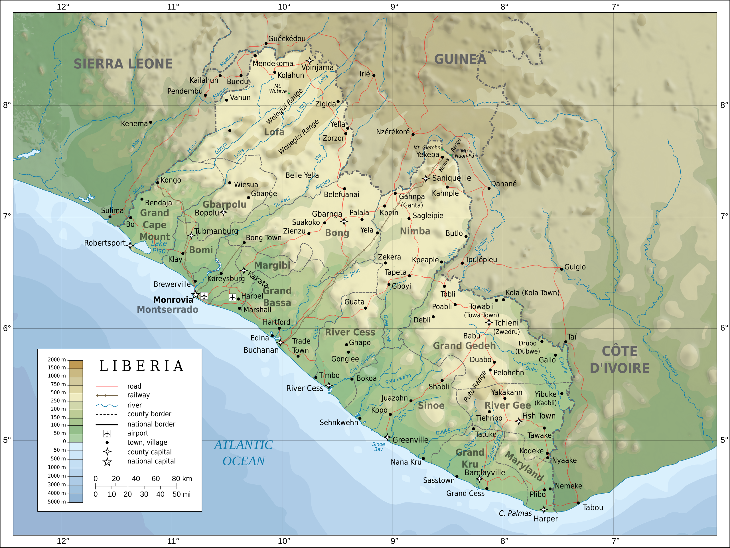
İzahTopographic map of Liberia-en.svg
English: Topographic map of Liberia.
Français : Carte topographique du Liberia.
Suomi: Liberian topografinen kartta.
Tarix
Mənbə
Self-made in Inkscape. Boundaries, rivers, roads, railroads, and place names based on a public domain United Nations map (Image:Un-liberia.png). Topography based on public domain GLOBE data from NOAA (http://www.ngdc.noaa.gov/mgg/topo/gltiles.html). Relief shading is an embedded PNG raster, derived from the GLOBE data using Perl. Bathymetry from NGDC ETOPO2.
Müəllif
Oona Räisänen (Mysid)
Digər versiyalar
Derivative works of this file: Railways in liberia-de.svg
Македонски
Russian
alman
This SVG file contains embedded text that can be translated into your language, using any capable SVG editor, text editor or the SVG Translate tool. For more information see: About translating SVG files.
Lisenziya
I, the copyright holder of this work, hereby publish it under the following licenses:
Bu sənədi GNU Azad Sənədləşdirmə Lisenziyası, Versiya 1.2 və ya Azad Proqram Fondu tərəfindən nəşr olunan hər hansı sonrakı versiya şərtlərinə əsasən dəyişməz bölmələr, ön qapaq mətnləri və arxa qapaq mətnləri olmadan köçürmək, yayımlamaq və / və ya dəyişdirmək üçün icazə verilir; Lisenziyanın bir nüsxəsi GNU Azad Sənədləşdirmə Lisenziyası adlı hissəyə daxil edilmişdir.http://www.gnu.org/copyleft/fdl.htmlGFDLGNU Free Documentation Licensetruetrue
This file is licensed under the Creative Commons Attribution-Share Alike 4.0 International, 3.0 Unported, 2.5 Generic, 2.0 Generic and 1.0 Generic license.
Azadsınız:
paylaşmaq – əsəri köçürmək, paylamaq və ötürmək üçün
remiks etmək – əsəri adaptasiya etmək
Aşağıdakı şərtlərə riayət etməklə:
istinad – Müvafiq kredit verməlisiniz, lisenziyaya bir keçid verməlisiniz və dəyişikliklərin olub olmadığını bildirməlisiniz. Bunu hər hansı bir ağlabatan şəkildə edə bilərsiniz, ancaq lisenziyalaşdırıcının sizi və ya istifadənizi təsdiqləməsini təklif edən bir şəkildə deyil.
bənzər paylaşma – Əsəri remix edirsinizsə, dəyişdirirsinizsə və ya üzərində iş aparırsınızsa, öz töhfələrinizi orijinalda olduğu kimi eyni və ya uyğun lisenziya altında yayımlamalısınız.
fayl, topographic, liberia, fayl, faylın, tarixçəsi, fayl, keçidləri, faylın, qlobal, istifadəsibu, faylın, formatındakı, görünüşünün, ölçüsü, piksel, digər, ölçülər, piksel, piksel, piksel, piksel, piksel, piksel, faylın, orijinalı, 8206, faylı, nominal, olar. Fayl Faylin tarixcesi Fayl kecidleri Faylin qlobal istifadesiBu SVG faylin PNG formatindaki bu gorunusunun olcusu 799 600 piksel Diger olculer 320 240 piksel 640 480 piksel 1 023 768 piksel 1 280 961 piksel 2 560 1 922 piksel 3 148 2 363 piksel Faylin orijinali 8206 SVG fayli nominal olaraq 3 148 2 363 piksel faylin olcusu 1 69 MB Bu fayl Vikimedia Commons dadirve diger layihelerde istifade edile biler Faylin tesvir sehifesine get Xulase IzahTopographic map of Liberia en svg English Topographic map of Liberia Francais nbsp Carte topographique du Liberia Suomi Liberian topografinen kartta Tarix 12 may 2008 Menbe Self made in Inkscape Boundaries rivers roads railroads and place names based on a public domain United Nations map Image Un liberia png Topography based on public domain GLOBE data from NOAA http www ngdc noaa gov mgg topo gltiles html Relief shading is an embedded PNG raster derived from the GLOBE data using Perl Bathymetry from NGDC ETOPO2 Muellif Oona Raisanen Mysid Diger versiyalar Derivative works of this file nbsp Railways in liberia de svg Makedonski Russian alman This SVG file contains embedded text that can be translated into your language using any capable SVG editor text editor or the SVG Translate tool For more information see About translating SVG files Lisenziya I the copyright holder of this work hereby publish it under the following licenses Bu senedi GNU Azad Senedlesdirme Lisenziyasi Versiya 1 2 ve ya Azad Proqram Fondu terefinden nesr olunan her hansi sonraki versiya sertlerine esasen deyismez bolmeler on qapaq metnleri ve arxa qapaq metnleri olmadan kocurmek yayimlamaq ve ve ya deyisdirmek ucun icaze verilir Lisenziyanin bir nusxesi GNU Azad Senedlesdirme Lisenziyasi adli hisseye daxil edilmisdir http www gnu org copyleft fdl html GFDL GNU Free Documentation License true trueThis file is licensed under the Creative Commons Attribution Share Alike 4 0 International 3 0 Unported 2 5 Generic 2 0 Generic and 1 0 Generic license Azadsiniz paylasmaq eseri kocurmek paylamaq ve oturmek ucun remiks etmek eseri adaptasiya etmek Asagidaki sertlere riayet etmekle istinad Muvafiq kredit vermelisiniz lisenziyaya bir kecid vermelisiniz ve deyisikliklerin olub olmadigini bildirmelisiniz Bunu her hansi bir aglabatan sekilde ede bilersiniz ancaq lisenziyalasdiricinin sizi ve ya istifadenizi tesdiqlemesini teklif eden bir sekilde deyil benzer paylasma Eseri remix edirsinizse deyisdirirsinizse ve ya uzerinde is aparirsinizsa oz tohfelerinizi orijinalda oldugu kimi eyni ve ya uygun lisenziya altinda yayimlamalisiniz https creativecommons org licenses by sa 4 0 CC BY SA 4 0 Creative Commons Attribution Share Alike 4 0 true trueIstediyiniz lisenziyani sece bilersiniz CaptionsazerbaycancaAdd a one line explanation of what this file representsItems portrayed in this filetesvir edircopyright status nbsp ingiliscopyrighted nbsp ingilislisenziyaCreative Commons Attribution ShareAlike 1 0 Generic nbsp ingilisCreative Commons Attribution ShareAlike 3 0 Unported nbsp ingilisCreative Commons Attribution ShareAlike 4 0 International nbsp ingilisCreative Commons Attribution ShareAlike 2 5 Generic nbsp ingilisGNU Free Documentation License version 1 2 or later nbsp ingilisCreative Commons Attribution ShareAlike 2 0 Generic nbsp ingilisyaranma tarixi12 may 2008 Faylin tarixcesi Faylin evvelki versiyasini gormek ucun gun tarix bolmesindeki tarixlere klikleyin Tarix VaxtKicik sekilOlculerIstifadeciSerh indiki20 08 31 iyul 20103 148 2 363 1 69 MB Mysidremove the false dropoff from land to sea in shading 20 02 31 iyul 20103 148 2 363 1 69 MB Mysidfixed a couple of symbols clipped the shading layer 10 49 19 iyul 20103 148 2 363 2 64 MB Mysidargh forgot to update legend box 10 41 19 iyul 20103 148 2 363 2 64 MB Mysidrevised for consistency with my other maps 12 46 25 may 20083 148 2 363 2 87 MB Mysidborder in image layers in XML 18 34 12 may 20083 037 2 257 2 82 MB Mysidadding lakes airports legends 16 44 12 may 20083 037 2 257 2 81 MB Mysid int filedesc Information Description en Topographic map of Liberia fr Carte topographique du Liberia fi Liberian topografinen kartta Source Self made in Inkscape lt br gt Boundaries Fayl kecidleri Bu sekile olan kecidler Liberiya Faylin qlobal istifadesi Bu fayl asagidaki vikilerde istifade olunur ar wikipedia org layihesinde istifadesi ليبيريا جغرافيا ليبيريا قرار مجلس الأمن التابع للأمم المتحدة رقم 2025 bcl wikipedia org layihesinde istifadesi Plantilya KanEnotNaPanahon 07 26 be tarask wikipedia org layihesinde istifadesi Geagrafiya Liberyi be wikipedia org layihesinde istifadesi Geagrafiya Liberyi bn wikipedia org layihesinde istifadesi ল ইব র য ca wikipedia org layihesinde istifadesi Resolucio 1689 del Consell de Seguretat de les Nacions Unides Resolucio 1753 del Consell de Seguretat de les Nacions Unides ckb wikipedia org layihesinde istifadesi بڕیارنامەی ١٦٨٩ی ئەنجومەنی ئاسایش بڕیارنامەی ٢٠٢٥ی ئەنجومەنی ئاسایش de wikipedia org layihesinde istifadesi Benutzer Uwe Dedering Landerliste el wikipedia org layihesinde istifadesi Liberia en wikipedia org layihesinde istifadesi Liberia Geography of Liberia User Mysid vectors Wildlife of Liberia Outline of Liberia Portal Liberia United Nations Security Council Resolution 1689 United Nations Security Council Resolution 2025 SMS Victoria eu wikipedia org layihesinde istifadesi Liberia fa wikipedia org layihesinde istifadesi قطعنامه ۱۶۸۹ شورای امنیت قطعنامه ۲۰۲۵ شورای امنیت جغرافیای لیبریا fi wikipedia org layihesinde istifadesi Liberia Liberian maantiede fr wikipedia org layihesinde istifadesi Projet Cartographie Cartes standards Pays hr wikipedia org layihesinde istifadesi Cavalla hr wiktionary org layihesinde istifadesi Liberija hy wikipedia org layihesinde istifadesi Լիբերիա id wikipedia org layihesinde istifadesi Liberia Resolusi 1689 Dewan Keamanan Perserikatan Bangsa Bangsa io wikipedia org layihesinde istifadesi Liberia is wikipedia org layihesinde istifadesi Liberia it wikipedia org layihesinde istifadesi Liberia Geografia della Liberia Lofa Lawa fiume Guinea ka wikipedia org layihesinde istifadesi ლიბერიის გეოგრაფია lt wikipedia org layihesinde istifadesi Liberijos geografija mzn wikipedia org layihesinde istifadesi قطعنومه ۱۶۸۹ امنیت شورا قطعنومه ۲۰۲۵ امنیت شورا nds wikipedia org layihesinde istifadesi Liberia nl wikipedia org layihesinde istifadesi Resolutie 1689 Veiligheidsraad Verenigde Naties Resolutie 1753 Veiligheidsraad Verenigde Naties pl wikipedia org layihesinde istifadesi Geografia Liberii ps wikipedia org layihesinde istifadesi لیبریا ru wikipedia org layihesinde istifadesi Uchastnik Ivan A Krestinin Illyustracii Bu faylin qlobal istifadesine baxin Menbe https az wikipedia org wiki Fayl Topographic map of Liberia en svg, wikipedia, oxu, kitab, kitabxana, axtar, tap, hersey,
ne axtarsan burda
, en yaxsi meqale sayti, meqaleler, kitablar, oyrenmek, wiki, bilgi, tarix, seks, porno, indir, yukle, sex, azeri sex, azeri, seks yukle, sex yukle, izle, seks izle, porno izle, mobil seks, telefon ucun, chat, azeri chat, tanisliq, tanishliq, azeri tanishliq, sayt, medeni, medeni saytlar, chatlar, mekan, tanisliq mekani, mekanlari, yüklə, pulsuz, pulsuz yüklə, mp3, video, mp4, 3gp, jpg, jpeg, gif, png, şəkil, muisiqi, mahnı, kino, film, kitab, oyun, oyunlar.