Bu fayl "Vikimedia Commons"dadır və digər layihələrdə istifadə edilə bilər.
Faylın təsvir səhifəsinə get
Xülasə
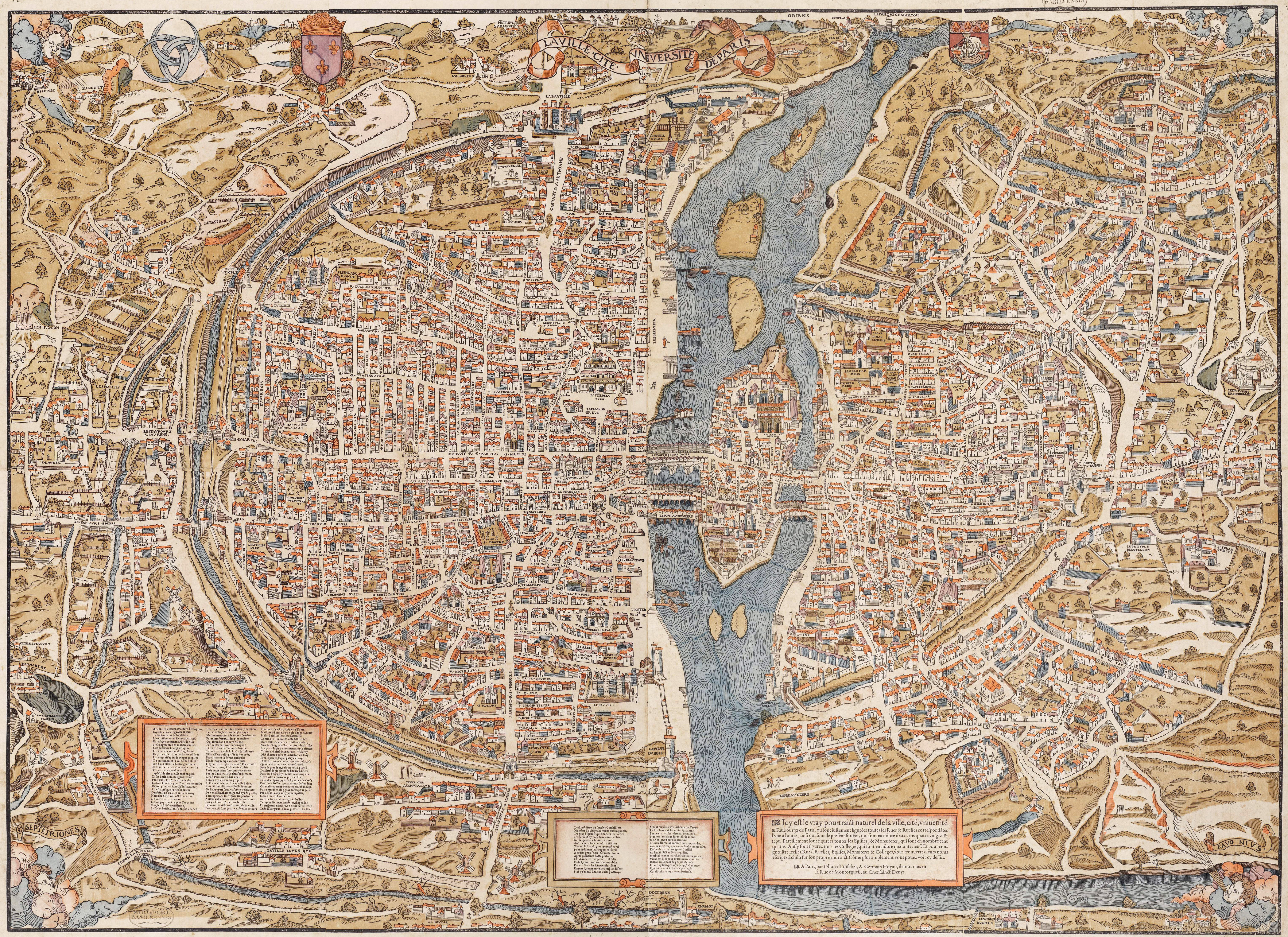
DescriptionPlan de Paris vers 1550 color.jpg
English: Plan of Paris by Truschet et Hoyau, scale ca. 1:4,500 (94 x 120 cm). Seefeld (Zurich) published this 1980 facsimile of the original map, also known as the plan de Bâle (Basel plan). Boutier gives a date of c. 1553 and estimates a scale of c. 1:7,000. The original is in color and was engraved on wood, 8 plates, 96 x 133 cm assembled.
Français : Le plan de Paris par Truschet et Hoyau, La ville, cité, université de Paris, échelle 1:4 500 environ (facsimile Seefeld, Zürich 1980).
References
InfoField
Boutier, Jean (2000). Les Plans de Paris, second edition, pp. 86–88. Paris: Bibliothèque nationale de France. ISBN 9782717723892.
{{Information |Description=Le plan de Paris par Truschet et Hoyau, ''La ville, cité, université de Paris'', ca. 1:4.500 (facsimile Seefeld, Zürich 1980) |Source=NL, Universiteitsbibliotheek Vrije Universiteit, LL.06979gk: 130/od/1550; http://imagebase.
Bu faylda fotoaparat və ya skanerlə əlavə olunmuş məlumatlar var. Əgər fayl sonradan redaktə olunubsa, bəzi parametrlər bu şəkildə göstərilənlərdən fərqli ola bilər.
_error
0
Yanvar 13, 2023
fayl, plan, paris, vers, 1550, color, fayl, faylın, tarixçəsi, istifadə, edilən, səhifələr, faylın, qlobal, istifadəsi, metaməlumatlarsınaq, göstərişi, ölçüsü, piksel, digər, ölçülər, piksel, piksel, piksel, piksel, piksel, piksel, faylın, orijinalı, 8206, pik. Fayl Faylin tarixcesi Istifade edilen sehifeler Faylin qlobal istifadesi MetamelumatlarSinaq gosterisi olcusu 800 582 piksel Diger olculer 320 233 piksel 640 466 piksel 1 024 745 piksel 1 280 931 piksel 2 560 1 863 piksel 6 108 4 444 piksel Faylin orijinali 8206 6 108 4 444 piksel fayl hecmi 23 18 MB MIME novu image jpeg Bu fayl Vikimedia Commons dadirve diger layihelerde istifade edile biler Faylin tesvir sehifesine get Xulase DescriptionPlan de Paris vers 1550 color jpg English Plan of Paris by Truschet et Hoyau scale ca 1 4 500 94 x 120 cm Seefeld Zurich published this 1980 facsimile of the original map also known as the plan de Bale Basel plan Boutier gives a date of c 1553 and estimates a scale of c 1 7 000 The original is in color and was engraved on wood 8 plates 96 x 133 cm assembled Francais Le plan de Paris par Truschet et Hoyau La ville cite universite de Paris echelle 1 4 500 environ facsimile Seefeld Zurich 1980 ReferencesInfoFieldBoutier Jean 2000 Les Plans de Paris second edition pp 86 88 Paris Bibliotheque nationale de France ISBN 9782717723892 Tarix circa 1550 date QS P 1550 00 00T00 00 00Z 9 P1480 Q5727902Menbe NL Universiteitsbibliotheek Vrije Universiteit LL 06979gk 130 od 1550 http imagebase ubvu vu nl getobj php ppn 330025988Yaradici Olivier Truschet engraver Germain Hoyau designer Georeferencing Georeference the map in Wikimaps Warper If inappropriate please set warp status skip to hide Diger versiyalar monochrome This formerly was a featured picture on Wikimedia Commons Featured pictures and was considered one of the finest images If you have an image of better quality that can be published under a suitable copyright license be sure to upload it tag it and nominate it Lisenziya Public domain Public domain false falseThis work is in the public domain in its country of origin and other countries and areas where the copyright term is the author s life plus 100 years or fewer You must also include a United States public domain tag to indicate why this work is in the public domain in the United States This file has been identified as being free of known restrictions under copyright law including all related and neighboring rights https creativecommons org publicdomain mark 1 0 PDM Creative Commons Public Domain Mark 1 0 false falseCaptionsazerbaycancaAdd a one line explanation of what this file representsingilisSixteenth century woodcut map of Paris Items portrayed in this filetesvir edirMIME type ingilisimage jpeg Faylin tarixcesi Faylin evvelki versiyasini gormek ucun gun tarix bolmesindeki tarixlere klikleyin Tarix VaxtKicik sekilOlculerIstifadeciSerh indiki12 17 30 may 20116 108 4 444 23 18 MB FA2010 Information Description Le plan de Paris par Truschet et Hoyau 039 039 La ville cite universite de Paris 039 039 ca 1 4 500 facsimile Seefeld Zurich 1980 Source NL Universiteitsbibliotheek Vrije Universiteit LL 06979gk 130 od 1550 http imagebase Istifade edilen sehifeler Bu sekile olan kecidler Paris orta esrlerde Vikipediya Heftenin secilmis meqalesi 23 Hefte 2016 Vikipediya Heftenin secilmis meqalesi 29 Hefte 2018 Vikipediya Heftenin secilmis meqalesi 29 Hefte 2022 Vikipediya Heftenin secilmis meqalesi iyul 2018 Vikipediya Heftenin secilmis meqalesi iyul 2022 Vikipediya Heftenin secilmis meqalesi iyun 2016 Faylin qlobal istifadesi Bu fayl asagidaki vikilerde istifade olunur en wikipedia org layihesinde istifadesi Paris in the Middle Ages User DondeEstaElBurro 1557 influenza pandemic User Northamerica1000 Topics es wikipedia org layihesinde istifadesi Pandemia de gripe de 1557 fr wikipedia org layihesinde istifadesi Rue Pierre au Lard Plans de Paris ja wikipedia org layihesinde istifadesi パリ nl wikipedia org layihesinde istifadesi Eerste kaarten van Parijs tr wikipedia org layihesinde istifadesi 1557 grip salgini uk wikipedia org layihesinde istifadesi Portal Geografiya Vibrana karta Arhiv vi wikipedia org layihesinde istifadesi Chủ đề Paris Hinh ảnh chọn lọcMetamelumatlar Bu faylda fotoaparat ve ya skanerle elave olunmus melumatlar var Eger fayl sonradan redakte olunubsa bezi parametrler bu sekilde gosterilenlerden ferqli ola biler error0 Menbe https az wikipedia org wiki Fayl Plan de Paris vers 1550 color jpg, wikipedia, oxu, kitab, kitabxana, axtar, tap, hersey,
ne axtarsan burda
, en yaxsi meqale sayti, meqaleler, kitablar, oyrenmek, wiki, bilgi, tarix, seks, porno, indir, yukle, sex, azeri sex, azeri, seks yukle, sex yukle, izle, seks izle, porno izle, mobil seks, telefon ucun, chat, azeri chat, tanisliq, tanishliq, azeri tanishliq, sayt, medeni, medeni saytlar, chatlar, mekan, tanisliq mekani, mekanlari, yüklə, pulsuz, pulsuz yüklə, mp3, video, mp4, 3gp, jpg, jpeg, gif, png, şəkil, muisiqi, mahnı, kino, film, kitab, oyun, oyunlar.