Bu fayl "Vikimedia Commons"dadır və digər layihələrdə istifadə edilə bilər.
Faylın təsvir səhifəsinə get
Xülasə
This is a featured picture on the ərəb language Wikipedia (صور مختارة) and is considered one of the finest images. This is a featured picture on the türk language Wikipedia (Seçkin resimler) and is considered one of the finest images.
If you think this file should be featured on Wikimedia Commons as well, feel free to nominate it. If you have an image of similar quality that can be published under a suitable copyright license, be sure to upload it, tag it, and nominate it.
İzahPiri reis world map 01.jpg
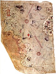
العربية: خارطة العالم بِيد أمير البحار العُثماني حاجي أحمد مُحيي الدين پیري، الشهير باسم پيري ريِّس، رُسمت سنة 1513م. لم يبقَ اليوم سوى نصف الخارطة الأصليَّة، التي يُحتفظ بها في متحف سراي طوپ قاپي في إسطنبول. تجمع هذه الخارطة معلومات من حوالي عشرين خريطة أُخرى، بما فيها إحدى الخرائط التي وضعها كريستوفر كولومبوس بنفسه وخطط فيها سواحل العالم الجديد.
English: Map of the world by Ottoman admiral Piri Reis, drawn in 1513. Only half of the original map survives and is held at the Topkapi Museum in Istanbul. The map synthesizes information from twenty maps, including one drawn by Christopher Columbus of the New World
Türkçe: Osmanlı amirali Piri Reis tarafından 1513'te çizilmiş olan, Avrupa ve Afrika'nın batı kıyılarıyla Güney Amerika'nın doğu kıyılarını gösteren dünyanın en eski haritalarından biri olan Piri Reis'in ilk Dünya haritası.
Tarix
Mənbə
Library of Topkapi Palace Museum, No. H 1824 Bilkent University (lo res), erisi.com (hi res)
Müəllif
Piri Rəis (circa 1467
date QS:P,+1467–00–00T00:00:00Z/9,P1480,Q5727902
– circa 1554
date QS:P,+1554–00–00T00:00:00Z/9,P1480,Q5727902
)
Alternativ adlar
Hac Ahmed Muhiddin Piri
İzah
Ottoman coğrafiyaşünas, xəritəşünas, zabit və Admiral
Doğum/ölüm tarixi
1470
1554
Doğum/ölüm yeri
Gelibolu yarımadası
Qahirə
Normativ yoxlama
: Q217915
VIAF: 173366743
ISNI: 0000 0004 4644 2939
ULAN: 500475834
LCCN: n50082435
GND: 119388405
WorldCat
creator QS:P170,Q217915
Lisenziya
Public domainPublic domainfalsefalse
https://creativecommons.org/publicdomain/mark/1.0/PDMCreative Commons Public Domain Mark 1.0falsefalse
Annotations
InfoField
This image is annotated: View the annotations at Commons
23
2463
37
37
2000
2753
Piri reis map. 12-9-09 global warming research Irene OBrien supposedly shows coast of antarctica before ice formed. drawn on animal skin and is only a partial piece of the map prime meridian is in Egypt
Captions
Add a one-line explanation of what this file represents
Yaptığı Harita
Items portrayed in this file
təsvir edir
MIME type ingilis
image/jpeg
Faylın tarixçəsi
Faylın əvvəlki versiyasını görmək üçün gün/tarix bölməsindəki tarixlərə klikləyin.
Reverted to version as of 04:00, 17 August 2012 (UTC) The higher resolution images that replaced this are horribly pixelated and have been created by enlarging a much smaller copy.
Bu faylda fotoaparat və ya skanerlə əlavə olunmuş məlumatlar var. Əgər fayl sonradan redaktə olunubsa, bəzi parametrlər bu şəkildə göstərilənlərdən fərqli ola bilər.
Orientasiya
Normal
Üfüqi xətt
400 dpi
Şaquli xətt
400 dpi
Proqram təminatı
Adobe Photoshop CS3 Windows
Faylın dəyişməsi tarixi və vaxtı
05:59, 17 avqust 2012
Rəng sahəsi
sRGB
Şəkilin eni
1.964 px
Şəkilin hündürlüyü
2.619 px
Tarix və vaxt rəqəmləşdirilir
07:59, 17 avqust 2012
Date metadata was last modified
07:59, 17 avqust 2012
Yanvar 20, 2023
fayl, piri, reis, world, fayl, faylın, tarixçəsi, istifadə, edilən, səhifələr, faylın, qlobal, istifadəsi, metaməlumatlarsınaq, göstərişi, ölçüsü, piksel, digər, ölçülər, piksel, piksel, piksel, piksel, piksel, faylın, orijinalı, 8206, piksel, fayl, həcmi, mim. Fayl Faylin tarixcesi Istifade edilen sehifeler Faylin qlobal istifadesi MetamelumatlarSinaq gosterisi olcusu 449 599 piksel Diger olculer 180 240 piksel 360 480 piksel 576 768 piksel 768 1 024 piksel 1 964 2 619 piksel Faylin orijinali 8206 1 964 2 619 piksel fayl hecmi 7 08 MB MIME novu image jpeg Bu fayl Vikimedia Commons dadirve diger layihelerde istifade edile biler Faylin tesvir sehifesine get Xulase This is a featured picture on the ereb language Wikipedia صور مختارة and is considered one of the finest images This is a featured picture on the turk language Wikipedia Seckin resimler and is considered one of the finest images If you think this file should be featured on Wikimedia Commons as well feel free to nominate it If you have an image of similar quality that can be published under a suitable copyright license be sure to upload it tag it and nominate it IzahPiri reis world map 01 jpg العربية خارطة العالم ب يد أمير البحار الع ثماني حاجي أحمد م حيي الدين پیري الشهير باسم پيري ري س ر سمت سنة 1513م لم يبق اليوم سوى نصف الخارطة الأصلي ة التي ي حتفظ بها في متحف سراي طوپ قاپي في إسطنبول تجمع هذه الخارطة معلومات من حوالي عشرين خريطة أ خرى بما فيها إحدى الخرائط التي وضعها كريستوفر كولومبوس بنفسه وخطط فيها سواحل العالم الجديد English Map of the world by Ottoman admiral Piri Reis drawn in 1513 Only half of the original map survives and is held at the Topkapi Museum in Istanbul The map synthesizes information from twenty maps including one drawn by Christopher Columbus of the New World Turkce Osmanli amirali Piri Reis tarafindan 1513 te cizilmis olan Avrupa ve Afrika nin bati kiyilariyla Guney Amerika nin dogu kiyilarini gosteren dunyanin en eski haritalarindan biri olan Piri Reis in ilk Dunya haritasi Tarix 1513Menbe Library of Topkapi Palace Museum No H 1824 Bilkent University lo res erisi com hi res Muellif Piri Reis circa 1467 date QS P 1467 00 00T00 00 00Z 9 P1480 Q5727902 circa 1554 date QS P 1554 00 00T00 00 00Z 9 P1480 Q5727902 Alternativ adlar Hac Ahmed Muhiddin PiriIzah Ottoman cografiyasunas xeritesunas zabit ve AdmiralDogum olum tarixi 1470 1554 Dogum olum yeri Gelibolu yarimadasiQahireNormativ yoxlama Q217915 VIAF 173366743 ISNI 0000 0004 4644 2939 ULAN 500475834 LCCN n50082435 GND 119388405 WorldCat creator QS P170 Q217915 Lisenziya Public domain Public domain false falseThis work is in the public domain in its country of origin and other countries and areas where the copyright term is the author s life plus 100 years or fewer You must also include a United States public domain tag to indicate why this work is in the public domain in the United States This file has been identified as being free of known restrictions under copyright law including all related and neighboring rights https creativecommons org publicdomain mark 1 0 PDM Creative Commons Public Domain Mark 1 0 false falseAnnotationsInfoFieldThis image is annotated View the annotations at Commons23 2463 37 37 2000 2753 Piri reis map 12 9 09 global warming research Irene OBrien supposedly shows coast of antarctica before ice formed drawn on animal skin and is only a partial piece of the map prime meridian is in EgyptCaptionsazerbaycancaAdd a one line explanation of what this file representsturkYaptigi HaritaItems portrayed in this filetesvir edirMIME type ingilisimage jpeg Faylin tarixcesi Faylin evvelki versiyasini gormek ucun gun tarix bolmesindeki tarixlere klikleyin Tarix VaxtKicik sekilOlculerIstifadeciSerh indiki23 16 17 iyul 20171 964 2 619 7 08 MB EarthsoundReverted to version as of 04 00 17 August 2012 UTC The higher resolution images that replaced this are horribly pixelated and have been created by enlarging a much smaller copy 12 45 13 noyabr 20163 387 4 807 2 16 MB Alonso de Mendozacolor 13 19 5 mart 20163 387 4 807 1 6 MB ديفيد عادل وهبة خليل 2Cropped 5 horizontally and 5 vertically using CropTool with precise mode 10 37 23 noyabr 20143 564 5 040 1 019 KB Ratzerhigher Resolution 3564 x 5040 source http www erisi com gelisim harita pri piri dunya jpg 04 00 17 avqust 20121 964 2 619 7 08 MB FunkMonk 02 45 10 fevral 20082 000 2 753 2 27 MB FunkMonk Information Description Source Date Author Permission other versions 14 45 13 sentyabr 2006829 1 087 205 KB InfoCanrotated previous version of map so North is up 07 09 29 sentyabr 20051 087 829 338 KB CristianChiritaPiri Reis World Map Istifade edilen sehifeler Bu sekile olan kecidler Cografiya Piri Reis Piri Reis xeritesi Topqapi sarayi Faylin qlobal istifadesi Bu fayl asagidaki vikilerde istifade olunur ar wikipedia org layihesinde istifadesi جزر الأنتيل بوابة الدولة العثمانية صورة ويكيبيديا صور مختارة رسومات وجداول وخرائط خرائط بيري ريس خريطة بيري ريس ويكيبيديا ترشيحات الصور المختارة خريطة أحمد محيي الدين امريكا ويكيبيديا صورة اليوم المختارة مايو 2016 قالب صورة اليوم المختارة 2016 05 23 بوابة الدولة العثمانية صورة مختارة 19 ويكيبيديا صورة اليوم المختارة أغسطس 2017 قالب صورة اليوم المختارة 2017 08 22 ويكيبيديا صورة اليوم المختارة يوليو 2019 قالب صورة اليوم المختارة 2019 07 23 كتاب الملاحة ويكيبيديا صورة اليوم المختارة يناير 2022 قالب صورة اليوم المختارة 2022 01 15 azb wikipedia org layihesinde istifadesi عثمانلی کارائیپی پو رتال تورکیه Did you know Archive bg wikipedia org layihesinde istifadesi Kartografiya Piri Reis Zabraneniyat pt Karta na Piri Reis bn wikipedia org layihesinde istifadesi প র র ইস প র র ইস র ম নচ ত র উসম ন য ন ব হ ন ca wikipedia org layihesinde istifadesi Piri Reis Mapa de Piri Reis ckb wikipedia org layihesinde istifadesi پیری ڕئیس cs wikipedia org layihesinde istifadesi Dejiny Antarktidy Piri Reis da wikipedia org layihesinde istifadesi Piri Reis Kartograf de wikipedia org layihesinde istifadesi 1513 Piri Reis Karte des Piri Reis Antillen Entwicklungsgeschichte der Seekarte Portal Diskussion Turkei Bild der Woche Kandidaten Archiv 2008 Benutzer DasAugeDerWahrheit Portal Diskussion Turkei Archiv 2009 Portal Turkei Bild Archiv Charles Hapgood Liste historischer Weltkarten Theorie der muslimischen Entdeckung Amerikas en wikipedia org layihesinde istifadesi List of cartographers Piri Reis Terra Australis Science in the medieval Islamic world History of the Ottoman Empire Piri Reis map Bu faylin qlobal istifadesine baxin Metamelumatlar Bu faylda fotoaparat ve ya skanerle elave olunmus melumatlar var Eger fayl sonradan redakte olunubsa bezi parametrler bu sekilde gosterilenlerden ferqli ola biler OrientasiyaNormalUfuqi xett400 dpiSaquli xett400 dpiProqram teminatiAdobe Photoshop CS3 WindowsFaylin deyismesi tarixi ve vaxti05 59 17 avqust 2012Reng sahesisRGBSekilin eni1 964 pxSekilin hundurluyu2 619 pxTarix ve vaxt reqemlesdirilir07 59 17 avqust 2012Date metadata was last modified07 59 17 avqust 2012 Menbe https az wikipedia org wiki Fayl Piri reis world map 01 jpg, wikipedia, oxu, kitab, kitabxana, axtar, tap, hersey,
ne axtarsan burda
, en yaxsi meqale sayti, meqaleler, kitablar, oyrenmek, wiki, bilgi, tarix, seks, porno, indir, yukle, sex, azeri sex, azeri, seks yukle, sex yukle, izle, seks izle, porno izle, mobil seks, telefon ucun, chat, azeri chat, tanisliq, tanishliq, azeri tanishliq, sayt, medeni, medeni saytlar, chatlar, mekan, tanisliq mekani, mekanlari, yüklə, pulsuz, pulsuz yüklə, mp3, video, mp4, 3gp, jpg, jpeg, gif, png, şəkil, muisiqi, mahnı, kino, film, kitab, oyun, oyunlar.