Bu fayl "Vikimedia Commons"dadır və digər layihələrdə istifadə edilə bilər.
Faylın təsvir səhifəsinə get
Xülasə
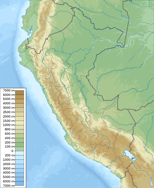
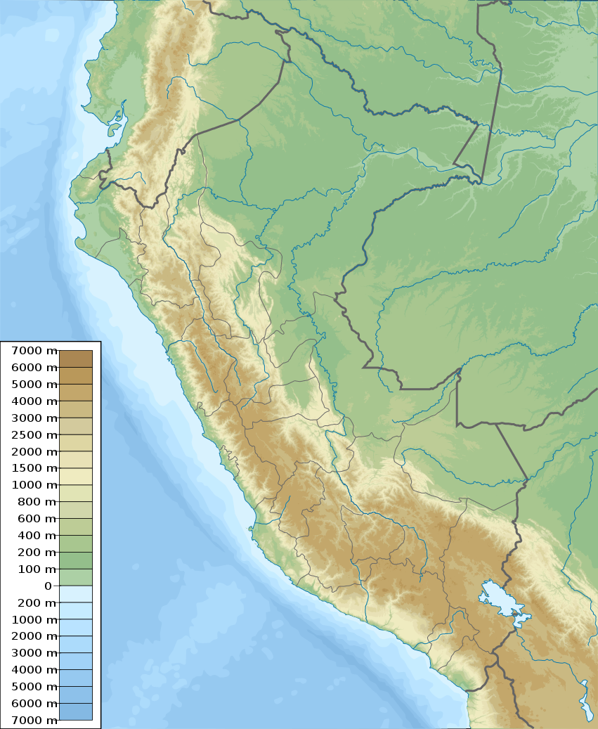
İzahPeru physical map.svg
English: Physical map of Peru, parameters are equal to File:Peru location map.svg
Tarix
Mənbə
Öz işi, topographical information from Shuttle Radar Topography Mission
Müəllif
Urutseg
SVG genesis
InfoField
The source code of this large SVG is valid.
This oversized map was created with Adobe Illustrator,
and with Inkscape.
This map uses embedded text that can be easily translated using a text editor.
Lisenziya
I, the copyright holder of this work, hereby publish it under the following license:
This file is made available under the Creative Commons CC0 1.0 Universal Public Domain Dedication.
The person who associated a work with this deed has dedicated the work to the public domain by waiving all of their rights to the work worldwide under copyright law, including all related and neighboring rights, to the extent allowed by law. You can copy, modify, distribute and perform the work, even for commercial purposes, all without asking permission.
http://creativecommons.org/publicdomain/zero/1.0/deed.enCC0Creative Commons Zero, Public Domain Dedicationfalsefalse
Captions
Add a one-line explanation of what this file represents
Bu faylda fotoaparat və ya skanerlə əlavə olunmuş məlumatlar var. Əgər fayl sonradan redaktə olunubsa, bəzi parametrlər bu şəkildə göstərilənlərdən fərqli ola bilər.
Genişlik
851.186px
Hündürlük
1036.854px
Dekabr 26, 2022
fayl, peru, physical, fayl, faylın, tarixçəsi, istifadə, edilən, səhifələr, faylın, qlobal, istifadəsi, metaməlumatlarbu, faylın, formatındakı, görünüşünün, ölçüsü, piksel, digər, ölçülər, piksel, piksel, piksel, piksel, piksel, piksel, faylın, orijinalı, 8206. Fayl Faylin tarixcesi Istifade edilen sehifeler Faylin qlobal istifadesi MetamelumatlarBu SVG faylin PNG formatindaki bu gorunusunun olcusu 492 600 piksel Diger olculer 197 240 piksel 394 480 piksel 630 768 piksel 840 1 024 piksel 1 681 2 048 piksel 851 1 037 piksel Faylin orijinali 8206 SVG fayli nominal olaraq 851 1 037 piksel faylin olcusu 4 81 MB Bu fayl Vikimedia Commons dadirve diger layihelerde istifade edile biler Faylin tesvir sehifesine get Xulase IzahPeru physical map svg English Physical map of Peru parameters are equal to File Peru location map svgTarix 5 mart 2011Menbe Oz isi topographical information from Shuttle Radar Topography MissionMuellif UrutsegSVG genesisInfoField The source code of this large SVG is valid This oversized map was created with Adobe Illustrator and with Inkscape This map uses embedded text that can be easily translated using a text editor Lisenziya I the copyright holder of this work hereby publish it under the following license This file is made available under the Creative Commons CC0 1 0 Universal Public Domain Dedication The person who associated a work with this deed has dedicated the work to the public domain by waiving all of their rights to the work worldwide under copyright law including all related and neighboring rights to the extent allowed by law You can copy modify distribute and perform the work even for commercial purposes all without asking permission http creativecommons org publicdomain zero 1 0 deed en CC0 Creative Commons Zero Public Domain Dedication false falseCaptionsazerbaycancaAdd a one line explanation of what this file representsingilisPhysical map of PerufransizSabancayaalmanPeru physische KarteItems portrayed in this filetesvir edirPeruyaradiciSome value without a Vikiverilenler itemmuellifin qisa adi UrutsegWikimedia username ingilis UrutsegURL ingilis https commons wikimedia org wiki User Urutsegcopyright status ingiliscopyrighted dedicated to the public domain by copyright holder ingilislisenziyaCC0 ingilissource of file ingilisoriginal creation by uploader ingilisyaranma tarixi5 mart 2011MIME type ingilisimage svg xml Faylin tarixcesi Faylin evvelki versiyasini gormek ucun gun tarix bolmesindeki tarixlere klikleyin Tarix VaxtKicik sekilOlculerIstifadeciSerh indiki10 42 5 mart 2011851 1 037 4 81 MB Urutseg Summary Information Description en 1 Physical map of Peru parameters are equal to Bolivia location map svg Source own Author Urutseg Date 2011 03 05 Pe Istifade edilen sehifeler Bu sekile olan kecidler Amazon yagis meseleri Grau denizi Manu Milli Parki Parakas yarimadasi Peru zelzelesi 2018 Secura Titikaka golu Uaskaran Milli Parki Sablon Yer xeritesi Peru Faylin qlobal istifadesi Bu fayl asagidaki vikilerde istifade olunur ar wikipedia org layihesinde istifadesi ماتشو بيتشو قالب خريطة مواقع بيرو زلزال بيرو 2018 زلزال بيرو 1687 بحيرة أكشيكوتشا ast wikipedia org layihesinde istifadesi Modulu Minimapa data Peru Modulu Minimapa data Peru usu ban wikipedia org layihesinde istifadesi Taman Nasional Cutervo Taman Nasional Huascaran Taman Nasional Manu Taman Nasional Rio Abiseo bar wikipedia org layihesinde istifadesi Vorlog Positionskarte Peru ba wikipedia org layihesinde istifadesi Ҡalyp PozKarta Peru be tarask wikipedia org layihesinde istifadesi Shablyon Lyakalizacyjnaya mapa Peru be wikipedia org layihesinde istifadesi Karapuna Uaskaran Tytykaka Shablon Na karce Peru Ukayali Urubamba Ualyaga Rymak Nacyyanalny park Manu Uajnapucina bg wikipedia org layihesinde istifadesi Kusko Truhilo Peru Lima Kalyao Arekipa Kahamarka Shablon PK Peru Machu Pikchu Laurikocha Uinyaj Uajna Titikaka Urubamba Alpamajo Piura Rinkonada Kahatambo Chimbote Ika grad Puerto Maldonado Puno Tarapoto Znaci v Naska Ayakucho Chuschi Chiklajo Uankajo Bu faylin qlobal istifadesine baxin Metamelumatlar Bu faylda fotoaparat ve ya skanerle elave olunmus melumatlar var Eger fayl sonradan redakte olunubsa bezi parametrler bu sekilde gosterilenlerden ferqli ola biler Genislik851 186pxHundurluk1036 854px Menbe https az wikipedia org wiki Fayl Peru physical map svg, wikipedia, oxu, kitab, kitabxana, axtar, tap, hersey,
ne axtarsan burda
, en yaxsi meqale sayti, meqaleler, kitablar, oyrenmek, wiki, bilgi, tarix, seks, porno, indir, yukle, sex, azeri sex, azeri, seks yukle, sex yukle, izle, seks izle, porno izle, mobil seks, telefon ucun, chat, azeri chat, tanisliq, tanishliq, azeri tanishliq, sayt, medeni, medeni saytlar, chatlar, mekan, tanisliq mekani, mekanlari, yüklə, pulsuz, pulsuz yüklə, mp3, video, mp4, 3gp, jpg, jpeg, gif, png, şəkil, muisiqi, mahnı, kino, film, kitab, oyun, oyunlar.