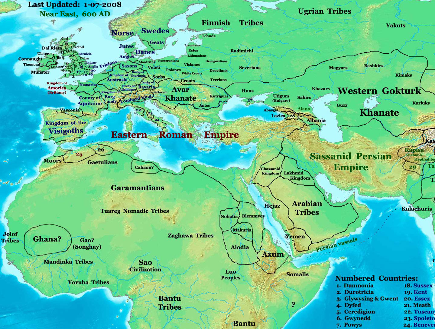
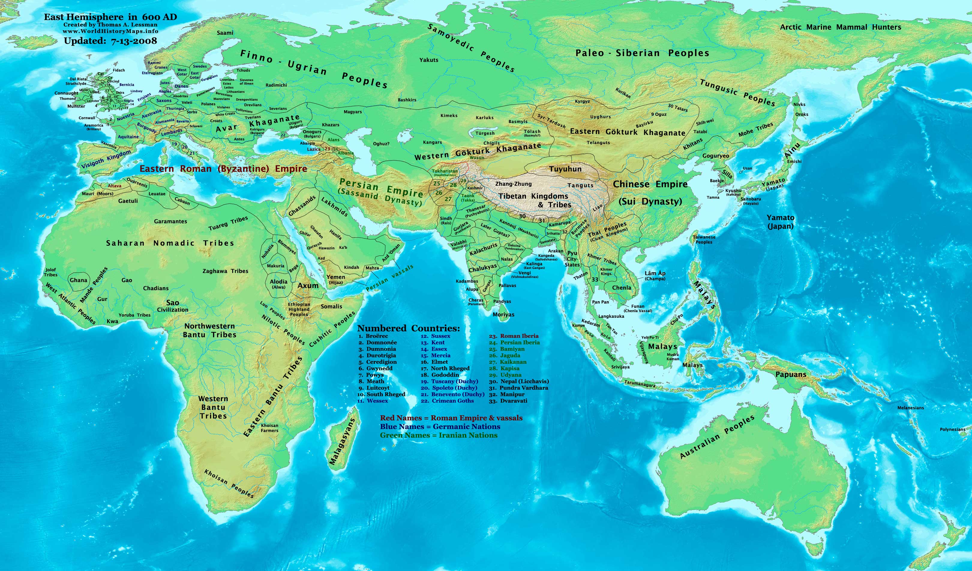
Image Summary:Created by Thomas Lessman, based on this map of Eastern Hemisphere in 600 AD. Free for educational use. If you use this image, please credit the author (Thomas Lessman) and include (Source URL: http://www.worldhistorymaps.info/images/East-Hem_600ad.jpg). If you can help improve this map, please contact Thomas Lessman at talessman@yis.us.
Other Historical Maps by Thomas Lessman
Maps of the eastern hemisphere showing history
Bold dates are available on Wikimedia or Wikipedia. (Other dates are available on www.WorldHistoryMaps.info.) See also: * Disclaimers * Report Errors * Gallery of Maps
Primeval
·| 1300 BC | 1000 BC | 625 BC |
Ancient
BC / BCE
AD / CE
·| 600 BC | 550 BC | 527 BC | 500 BC | 400 BC | ·| 335 BC | 323 BC | 300 BC | 200 BC | ·| 100 BC | 50 BC |
·| 1 AD | 50 AD | 100 AD | 200 AD | 300 AD | ·| 400 AD | 475 AD | 476 AD | 477 AD | ·| 480 AD | 486 AD|
Medieval
·| 500 AD | 565 AD | 600 AD | 700 AD | · | 800 AD | 900 AD | 1025 AD | ·| 1100 AD | 1200 AD | 1300 AD | 1400 AD |
Modern
·| 1500 AD |·* For historical maps of the whole world, see Wikimedia's Template:Maps of world history.
history links talk edit view
Tarix
17 yanvar 2008 (original upload date)
Mənbə
Transferred from en.wikipedia to Commons.
Müəllif
Talessman at ingilis Vikipediya
İcazə (Faylın təkrar istifadəsi)
Public domainPublic domainfalsefalse
Digər versiyalar
Disputed map because the version with « Romanised Dacians » (= Olahok, Vlachs) and « Slavs » (Totok, Slavons, Slovens...) may be a romanian and slavic POV, but this « Only Avars and no other people north of the Danube, in the future Kingdom of Hungary », according to the Eduard Rössler's « Awarenwüste » theory, shows an Austrian-Hungarian POV: one is not more objective than the other and unfortunately no synthesis is possible.
Lisenziya
Talessman at the English Wikipedia, the copyright holder of this work, hereby publishes it under the following license:
Bu sənədi GNU Azad Sənədləşdirmə Lisenziyası, Versiya 1.2 və ya Azad Proqram Fondu tərəfindən nəşr olunan hər hansı sonrakı versiya şərtlərinə əsasən dəyişməz bölmələr, ön qapaq mətnləri və arxa qapaq mətnləri olmadan köçürmək, yayımlamaq və / və ya dəyişdirmək üçün icazə verilir; Lisenziyanın bir nüsxəsi GNU Azad Sənədləşdirmə Lisenziyası adlı hissəyə daxil edilmişdir.http://www.gnu.org/copyleft/fdl.htmlGFDLGNU Free Documentation Licensetruetrue
Bu fayl Creative Commons Attribution-Share Alike 3.0 Sinqapur lisenziyası altında yayımlanır.
İstinad: Talessman at the English Wikipedia
Azadsınız:
paylaşmaq – əsəri köçürmək, paylamaq və ötürmək üçün
remiks etmək – əsəri adaptasiya etmək
Aşağıdakı şərtlərə riayət etməklə:
istinad – Müvafiq kredit verməlisiniz, lisenziyaya bir keçid verməlisiniz və dəyişikliklərin olub olmadığını bildirməlisiniz. Bunu hər hansı bir ağlabatan şəkildə edə bilərsiniz, ancaq lisenziyalaşdırıcının sizi və ya istifadənizi təsdiqləməsini təklif edən bir şəkildə deyil.
bənzər paylaşma – Əsəri remix edirsinizsə, dəyişdirirsinizsə və ya üzərində iş aparırsınızsa, öz töhfələrinizi orijinalda olduğu kimi eyni və ya uyğun lisenziya altında yayımlamalısınız.
This licensing tag was added to this file as part of the GFDL licensing update.http://creativecommons.org/licenses/by-sa/3.0/CC-BY-SA-3.0Creative Commons Attribution-Share Alike 3.0truetrue
This box: [[Template:|view]] • [[|talk]] •[[[:Template:Fullurl:Template:]] edit]
Maps of the eastern hemisphere showing history
Bold dates are available on Wikimedia or Wikipedia. (Other dates are available on www.WorldHistoryMaps.info.) See also: * Disclaimers * Report Errors * Gallery of Maps
Primeval
·| 1300 BC | 1000 BC | 625 BC |
Ancient
BC / BCE
AD / CE
·| 600 BC | 550 BC | 527 BC | 500 BC | 400 BC | ·| 335 BC | 323 BC | 300 BC | 200 BC | ·| 100 BC | 50 BC |
·| 1 AD | 50 AD | 100 AD | 200 AD | 300 AD | ·| 400 AD | 475 AD | 476 AD | 477 AD | ·| 480 AD | 486 AD|
Medieval
·| 500 AD | 565 AD | 600 AD | 700 AD | · | 800 AD | 900 AD | 1025 AD | ·| 1100 AD | 1200 AD | 1300 AD | 1400 AD |
Modern
·| 1500 AD |·* For historical maps of the whole world, see Wikimedia's Template:Maps of world history.
history links talk edit view
·
Orijinal yükləmə gündəliyi
The original description page was here. All following user names refer to en.wikipedia.
2008-01-17 20:07 Talessman 1439×1086× (513542 bytes) Added more info for Africa, corrected some info on Europe.
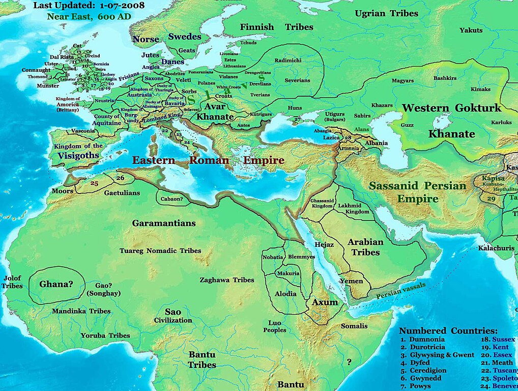
2007-11-02 18:55 Talessman 1450×988× (440135 bytes) Corrected borders in Africa/Sudan and Arabia.
2007-10-31 20:30 Talessman 1429×927× (437106 bytes) Corrected borders of Ghana, made other names easier to read, other misc. corrections.
2007-10-21 00:19 Talessman 1251×779× (341469 bytes) Author: Thomas A. Lessman. Source URL: http://www.ThomasLessman.com/History/images/East-Hem_600ad.jpg. Image was created by me (Thomas Lessman) based on map of Eastern Hemisphere in 600ad. Image is free for public and/or educational use. I would appreciat
Captions
Add a one-line explanation of what this file represents
Items portrayed in this file
təsvir edir
copyright status ingilis
copyrighted ingilis
lisenziya
GNU Free Documentation License, version 1.2 or later ingilis
Creative Commons Attribution-ShareAlike 3.0 Unported ingilis
yaranma tarixi
17 yanvar 2008
MIME type ingilis
image/jpeg
Faylın tarixçəsi
Faylın əvvəlki versiyasını görmək üçün gün/tarix bölməsindəki tarixlərə klikləyin.
Reverted to version as of 09:20, 1 February 2009 (UTC) "Romance Dacians in 600" in Transylvania is clearly a Romanian nationalist POV, and there is Avar archeological sites, but the Avar territory was decreased in the updated map. Dacians in 600???
Reverted to version as of 09:20, 1 February 2009 (UTC) restored the original one which was extract from the big original map, the map was falsified with did not exist nations at that time 600 AD
Dervivative work since Thomas Lessmann & Julo, with little changes according with H.E. Stier (dir.), « Grosser Atlas zur Weltgeschichte », Westermann 1985, ISBN 3-14-100919-8
{{Information |Description={{en|'''thumb|300px|left|Eastern Hemisphere in 600 AD.''' '''Description:''' This image is a zoomed-in version of the [http://en.wikipedia.org/wiki/Image:East-Hem_600ad.jpg Eastern Hemisphere in
fayl, 600ad, fayl, faylın, tarixçəsi, istifadə, edilən, səhifələr, faylın, qlobal, istifadəsisınaq, göstərişi, ölçüsü, piksel, digər, ölçülər, piksel, piksel, piksel, piksel, piksel, faylın, orijinalı, 8206, piksel, fayl, həcmi, mime, növü, image, jpeg, fayl, . Fayl Faylin tarixcesi Istifade edilen sehifeler Faylin qlobal istifadesiSinaq gosterisi olcusu 795 600 piksel Diger olculer 318 240 piksel 636 480 piksel 1 018 768 piksel 1 280 966 piksel 1 439 1 086 piksel Faylin orijinali 8206 1 439 1 086 piksel fayl hecmi 502 KB MIME novu image jpeg Bu fayl Vikimedia Commons dadirve diger layihelerde istifade edile biler Faylin tesvir sehifesine get Mundericat 1 Xulase 2 Other Historical Maps by Thomas Lessman 3 Lisenziya 4 Orijinal yukleme gundeliyi Xulase The factual accuracy of this map or the file name is disputed Reason Please see the relevant discussion on the talk page IzahNE 600ad jpg English part of Eastern Hemisphere in 600 AD Description This image is a zoomed in version of the Eastern Hemisphere in 600 AD Author Thomas A Lessman talessman yis us later modified by others Source URL http www worldhistorymaps info images East Hem 600ad jpg Image Summary Created by Thomas Lessman based on this map of Eastern Hemisphere in 600 AD Free for educational use If you use this image please credit the author Thomas Lessman and include Source URL http www worldhistorymaps info images East Hem 600ad jpg If you can help improve this map please contact Thomas Lessman at talessman yis us Other Historical Maps by Thomas Lessman Maps of the eastern hemisphere showing history Bold dates are available on Wikimedia or Wikipedia Other dates are available on www WorldHistoryMaps info See also Disclaimers Report Errors Gallery of MapsPrimeval 1300 BC 1000 BC 625 BC Ancient BC BCEAD CE 600 BC 550 BC 527 BC 500 BC 400 BC 335 BC 323 BC 300 BC 200 BC 100 BC 50 BC 1 AD 50 AD 100 AD 200 AD 300 AD 400 AD 475 AD 476 AD 477 AD 480 AD 486 AD Medieval 500 AD 565 AD 600 AD 700 AD 800 AD 900 AD 1025 AD 1100 AD 1200 AD 1300 AD 1400 AD Modern 1500 AD For historical maps of the whole world see Wikimedia s Template Maps of world history history links talk edit viewTarix 17 yanvar 2008 original upload date Menbe Transferred from en wikipedia to Commons Muellif Talessman at ingilis VikipediyaIcaze Faylin tekrar istifadesi Public domain Public domain false falseBu gorunus butunlukle ictimaiyyete aid melumatlardan meydana gelmesi ve her hansi bir xususi yaradiciya aid olmamasi sebebiyle ictimai varidat olaraq xarakterize edilmekdedir ve muellif huququ qorunmasina daxil deyildir Diger versiyalar Disputed map because the version with Romanised Dacians Olahok Vlachs and Slavs Totok Slavons Slovens may be a romanian and slavic POV but this Only Avars and no other people north of the Danube in the future Kingdom of Hungary according to the Eduard Rossler s Awarenwuste theory shows an Austrian Hungarian POV one is not more objective than the other and unfortunately no synthesis is possible Lisenziya Talessman at the English Wikipedia the copyright holder of this work hereby publishes it under the following license Bu senedi GNU Azad Senedlesdirme Lisenziyasi Versiya 1 2 ve ya Azad Proqram Fondu terefinden nesr olunan her hansi sonraki versiya sertlerine esasen deyismez bolmeler on qapaq metnleri ve arxa qapaq metnleri olmadan kocurmek yayimlamaq ve ve ya deyisdirmek ucun icaze verilir Lisenziyanin bir nusxesi GNU Azad Senedlesdirme Lisenziyasi adli hisseye daxil edilmisdir http www gnu org copyleft fdl html GFDL GNU Free Documentation License true trueBu fayl Creative Commons Attribution Share Alike 3 0 Sinqapur lisenziyasi altinda yayimlanir Istinad Talessman at the English WikipediaAzadsiniz paylasmaq eseri kocurmek paylamaq ve oturmek ucun remiks etmek eseri adaptasiya etmek Asagidaki sertlere riayet etmekle istinad Muvafiq kredit vermelisiniz lisenziyaya bir kecid vermelisiniz ve deyisikliklerin olub olmadigini bildirmelisiniz Bunu her hansi bir aglabatan sekilde ede bilersiniz ancaq lisenziyalasdiricinin sizi ve ya istifadenizi tesdiqlemesini teklif eden bir sekilde deyil benzer paylasma Eseri remix edirsinizse deyisdirirsinizse ve ya uzerinde is aparirsinizsa oz tohfelerinizi orijinalda oldugu kimi eyni ve ya uygun lisenziya altinda yayimlamalisiniz This licensing tag was added to this file as part of the GFDL licensing update http creativecommons org licenses by sa 3 0 CC BY SA 3 0 Creative Commons Attribution Share Alike 3 0 true true This box Template view talk Template Fullurl Template edit Maps of the eastern hemisphere showing history Bold dates are available on Wikimedia or Wikipedia Other dates are available on www WorldHistoryMaps info See also Disclaimers Report Errors Gallery of MapsPrimeval 1300 BC 1000 BC 625 BC Ancient BC BCEAD CE 600 BC 550 BC 527 BC 500 BC 400 BC 335 BC 323 BC 300 BC 200 BC 100 BC 50 BC 1 AD 50 AD 100 AD 200 AD 300 AD 400 AD 475 AD 476 AD 477 AD 480 AD 486 AD Medieval 500 AD 565 AD 600 AD 700 AD 800 AD 900 AD 1025 AD 1100 AD 1200 AD 1300 AD 1400 AD Modern 1500 AD For historical maps of the whole world see Wikimedia s Template Maps of world history history links talk edit view Orijinal yukleme gundeliyi The original description page was here All following user names refer to en wikipedia 2008 01 17 20 07 Talessman 1439 1086 513542 bytes Added more info for Africa corrected some info on Europe 2007 11 02 18 55 Talessman 1450 988 440135 bytes Corrected borders in Africa Sudan and Arabia 2007 10 31 20 30 Talessman 1429 927 437106 bytes Corrected borders of Ghana made other names easier to read other misc corrections 2007 10 21 00 19 Talessman 1251 779 341469 bytes Author Thomas A Lessman Source URL http www ThomasLessman com History images East Hem 600ad jpg Image was created by me Thomas Lessman based on map of Eastern Hemisphere in 600ad Image is free for public and or educational use I would appreciatCaptionsazerbaycancaAdd a one line explanation of what this file representsItems portrayed in this filetesvir edircopyright status ingiliscopyrighted ingilislisenziyaGNU Free Documentation License version 1 2 or later ingilisCreative Commons Attribution ShareAlike 3 0 Unported ingilisyaranma tarixi17 yanvar 2008MIME type ingilisimage jpeg Faylin tarixcesi Faylin evvelki versiyasini gormek ucun gun tarix bolmesindeki tarixlere klikleyin Tarix VaxtKicik sekilOlculerIstifadeciSerh indiki13 38 28 oktyabr 20221 439 1 086 502 KB OrionNimrodReverted to version as of 09 20 1 February 2009 UTC Romance Dacians in 600 in Transylvania is clearly a Romanian nationalist POV and there is Avar archeological sites but the Avar territory was decreased in the updated map Dacians in 600 15 47 27 oktyabr 20221 439 1 086 744 KB Nihil scimusModifications from academic historical books do not invent nations or falsifie Commons 039 digital incomplete maps but enrich them 17 29 6 oktyabr 20221 439 1 086 502 KB OrionNimrodReverted to version as of 09 20 1 February 2009 UTC restored the original one which was extract from the big original map the map was falsified with did not exist nations at that time 600 AD 12 55 11 dekabr 20141 439 1 086 744 KB Spiridon Ion CepleanuGaramantian amp Arabic tribes areas 17 26 20 noyabr 20141 439 1 086 742 KB Spiridon Ion CepleanuLakes amp Caspian shorelines 13 21 15 noyabr 20141 439 1 086 737 KB Spiridon Ion CepleanuAdd missing names Altava Warsenia Iberia Kaikanan 13 00 15 noyabr 20141 439 1 086 736 KB Spiridon Ion CepleanuLittle cosmetic adds seas names in this time etc 18 26 14 noyabr 20141 439 1 086 711 KB Spiridon Ion CepleanuDervivative work since Thomas Lessmann amp Julo with little changes according with H E Stier dir Grosser Atlas zur Weltgeschichte Westermann 1985 ISBN 3 14 100919 8 09 20 1 fevral 20091 439 1 086 502 KB Julo Information Description en 039 039 039 thumb 300px left Eastern Hemisphere in 600 AD 039 039 039 039 039 039 Description 039 039 039 This image is a zoomed in version of the http en wikipedia org wiki Image East Hem 600ad jpg Eastern Hemisphere in Istifade edilen sehifeler Bu sekile olan kecidler Goyturk xaqanligi Turkdilli dovletler Zaqavalar Faylin qlobal istifadesi Bu fayl asagidaki vikilerde istifade olunur ast wikipedia org layihesinde istifadesi Kaganatu avaru Garamantes ba wikipedia org layihesinde istifadesi Bashҡorttar Unugyrҙar bg wikipedia org layihesinde istifadesi Kutriguri Onoguri Sao Garamanti ca wikipedia org layihesinde istifadesi Garamants cv wikipedia org layihesinde istifadesi Vătărkăr Kătărkăr el wikipedia org layihesinde istifadesi Garamantes en wikipedia org layihesinde istifadesi Garamantes Kutrigurs Utigurs en wikiversity org layihesinde istifadesi Draft Original research Libyan history es wikipedia org layihesinde istifadesi Antigua Gran Bulgaria Garamantes Kanato avaro Cutriguros fa wikipedia org layihesinde istifadesi گرامه ای ها fr wikipedia org layihesinde istifadesi Sassanides Avars Heraclius Histoire de l Europe Blemmyes Garamantes Makurie Onoghours Nobatie Royaume d Alodie Royaume d Aksoum Vistahm Echanges commerciaux entre la Rome antique et l Inde Koutrigoures hu wikipedia org layihesinde istifadesi Ogurok Onogur bolgarok Utrigurok Kutrigurok id wikipedia org layihesinde istifadesi Kutrigur it wikipedia org layihesinde istifadesi Garamanti Onoguri Kutriguri ja wikipedia org layihesinde istifadesi サハラ交易 ko wikipedia org layihesinde istifadesi 가라만테스 lt wikipedia org layihesinde istifadesi Vakaru tiurku kaganatas nl wikipedia org layihesinde istifadesi Kutriguren oc wikipedia org layihesinde istifadesi Axom Reialme d Axom pl wikipedia org layihesinde istifadesi Garamantowie Bu faylin qlobal istifadesine baxin Menbe https az wikipedia org wiki Fayl NE 600ad jpg, wikipedia, oxu, kitab, kitabxana, axtar, tap, hersey,
ne axtarsan burda
, en yaxsi meqale sayti, meqaleler, kitablar, oyrenmek, wiki, bilgi, tarix, seks, porno, indir, yukle, sex, azeri sex, azeri, seks yukle, sex yukle, izle, seks izle, porno izle, mobil seks, telefon ucun, chat, azeri chat, tanisliq, tanishliq, azeri tanishliq, sayt, medeni, medeni saytlar, chatlar, mekan, tanisliq mekani, mekanlari, yüklə, pulsuz, pulsuz yüklə, mp3, video, mp4, 3gp, jpg, jpeg, gif, png, şəkil, muisiqi, mahnı, kino, film, kitab, oyun, oyunlar.