Bu fayl "Vikimedia Commons"dadır və digər layihələrdə istifadə edilə bilər.
Faylın təsvir səhifəsinə get
Xülasə
İzahCaspian Sea from orbit.jpg
العربية: منظرٌ من مدار الأرض لِبحر قزوين. التعليق الأصلي: كما أوردته وكالة الناسا: ::"القسم الشمالي من بحر قزوين يُعاني من ظاهرةٍ تُعرف باسم التخثث أو إغناء الماء، وهي تلك الحالة التي تتسببُ فيها الأسمدة الزراعيَّة المُنسابة من خِلال مياه الري والأمطار بِنُمو الطحالب في المياه. يُؤدي نُفوق وتحلُّل تلك الطحالب إلى حرمان المياه من الأكسجين، ممَّا يُؤدي بِدوره إلى الإضرار بِالحياة البريَّة بِطبيعة الحال. هذه الصُورة لِبحر قزوين تُظهرُ بعض الدوَّامات الخضراء والزرقاء على مقرُبةٍ من مصب نهر الڤولغا (أعلى الوسط)، ممَّا يدُل على وُجود كميَّةٍ من الطحالب. اللون الأزرق اللامع في القسم الشمالي الشرقي من البحر قد يكون تولَّد نتيجة اختلاط بعض النباتات بِالترسُبات، نظرًا لِأنَّ هذا الموقع هو أكثر المناطق ضُحولةً في البحر.
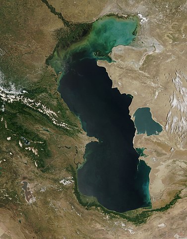
English: This is a view from orbit of the Caspian Sea as imaged by the MODIS sensor on the Terra satellite. Caption: The original caption from NASA: ::"The northern part of the Caspian Sea is plagued by a process called eutrophication, in which agricultural run-off rich in fertilizers stimulates rampant growth of algae in the water. The death and decay of these algae robs the water of oxygen, with obvious negative consequences for aquatic life. This image of the Caspian Sea shows swirls of green and blue near the mouth of the Volga River (top center), which indicate the presence of algae. The bright blue color of the northeastern part of the sea may be due to a mixture of plant life and sediment, for this is where the sea is most shallow. This image is from the Moderate Resolution Imaging Spectroradiometer (MODIS) on the Terra satellite on June 11, 2003.
Español: El Mar Caspio visto desde la órbita terrestre
Transferred from English Wikipedia, original upload 2 November 2004 by Kbh3rd en:Image:Caspian Sea from orbit.jpg
Müəllif
Jeff Schmaltz, MODIS Rapid Response Team, NASA/GSFC
Digər versiyalar
Derivative works of this file: Caspian Sea from orbit-NoRedLines.jpg
This file is marked as a valued image, but it is missing its scope! Please refer to Template:Assessments/doc!
This is a Valued image and is considered to meet the Valued image criteria. This is a featured picture on the ərəb language Wikipedia (صور مختارة) and is considered one of the finest images.
If you think this file should be featured on Wikimedia Commons as well, feel free to nominate it. If you have an image of similar quality that can be published under a suitable copyright license, be sure to upload it, tag it, and nominate it.
Lisenziya
Public domainPublic domainfalsefalse
Captions
XƏZƏR
Caspian Sea from orbit (here the image from MODIS of the Terra satellite on June 11, 2003)
Mar Cáspio.
Kaspisches Meer in der Satellitenansicht (hier das Bild von MODIS vom Satellit Terra am 11. Juni 2003)
تصویر ماهوارهای از دریای کاسپین
Items portrayed in this file
təsvir edir
Xəzər dənizi
Commons quality assessment ingilis
Wikimedia Commons valued image ingilis
yaranma tarixi
11 iyun 2003
MIME type ingilis
image/jpeg
Faylın tarixçəsi
Faylın əvvəlki versiyasını görmək üçün gün/tarix bölməsindəki tarixlərə klikləyin.
Bu faylda fotoaparat və ya skanerlə əlavə olunmuş məlumatlar var. Əgər fayl sonradan redaktə olunubsa, bəzi parametrlər bu şəkildə göstərilənlərdən fərqli ola bilər.
_error
0
Dekabr 27, 2022
fayl, caspian, from, orbit, fayl, faylın, tarixçəsi, istifadə, edilən, səhifələr, faylın, qlobal, istifadəsi, metaməlumatlarsınaq, göstərişi, ölçüsü, piksel, digər, ölçülər, piksel, piksel, piksel, piksel, piksel, piksel, faylın, orijinalı, 8206, piksel, fayl,. Fayl Faylin tarixcesi Istifade edilen sehifeler Faylin qlobal istifadesi MetamelumatlarSinaq gosterisi olcusu 471 599 piksel Diger olculer 188 240 piksel 377 480 piksel 603 768 piksel 804 1 024 piksel 1 609 2 048 piksel 4 400 5 600 piksel Faylin orijinali 8206 4 400 5 600 piksel fayl hecmi 3 44 MB MIME novu image jpeg Bu fayl Vikimedia Commons dadirve diger layihelerde istifade edile biler Faylin tesvir sehifesine get Xulase IzahCaspian Sea from orbit jpg العربية منظر من مدار الأرض ل بحر قزوين التعليق الأصلي كما أوردته وكالة الناسا القسم الشمالي من بحر قزوين ي عاني من ظاهرة ت عرف باسم التخثث أو إغناء الماء وهي تلك الحالة التي تتسبب فيها الأسمدة الزراعي ة الم نسابة من خ لال مياه الري والأمطار ب ن مو الطحالب في المياه ي ؤدي ن فوق وتحل ل تلك الطحالب إلى حرمان المياه من الأكسجين مم ا ي ؤدي ب دوره إلى الإضرار ب الحياة البري ة ب طبيعة الحال هذه الص ورة ل بحر قزوين ت ظهر بعض الدو امات الخضراء والزرقاء على مقر بة من مصب نهر الڤولغا أعلى الوسط مم ا يد ل على و جود كمي ة من الطحالب اللون الأزرق اللامع في القسم الشمالي الشرقي من البحر قد يكون تول د نتيجة اختلاط بعض النباتات ب الترس بات نظر ا ل أن هذا الموقع هو أكثر المناطق ض حولة في البحر English This is a view from orbit of the Caspian Sea as imaged by the MODIS sensor on the Terra satellite Caption The original caption from NASA The northern part of the Caspian Sea is plagued by a process called eutrophication in which agricultural run off rich in fertilizers stimulates rampant growth of algae in the water The death and decay of these algae robs the water of oxygen with obvious negative consequences for aquatic life This image of the Caspian Sea shows swirls of green and blue near the mouth of the Volga River top center which indicate the presence of algae The bright blue color of the northeastern part of the sea may be due to a mixture of plant life and sediment for this is where the sea is most shallow This image is from the Moderate Resolution Imaging Spectroradiometer MODIS on the Terra satellite on June 11 2003 Espanol El Mar Caspio visto desde la orbita terrestre فارسی تصویر ماهواره ای از دریای خزر Toҷikӣ Tasviri Baҳr Kaspӣ az osmonTarix 11 iyun 2003Menbe http visibleearth nasa gov view rec php id 5514 Transferred from English Wikipedia original upload 2 November 2004 by Kbh3rd en Image Caspian Sea from orbit jpgMuellif Jeff Schmaltz MODIS Rapid Response Team NASA GSFCDiger versiyalar Derivative works of this file Caspian Sea from orbit NoRedLines jpg This file is marked as a valued image but it is missing its scope Please refer to Template Assessments doc This is a Valued image and is considered to meet the Valued image criteria This is a featured picture on the ereb language Wikipedia صور مختارة and is considered one of the finest images If you think this file should be featured on Wikimedia Commons as well feel free to nominate it If you have an image of similar quality that can be published under a suitable copyright license be sure to upload it tag it and nominate it Lisenziya Public domain Public domain false falseThis file is in the public domain in the United States because it was solely created by NASA NASA copyright policy states that NASA material is not protected by copyright unless noted See Template PD USGov NASA copyright policy page or JPL Image Use Policy Warnings Use of NASA logos insignia and emblems is restricted per U S law 14 CFR 1221 The NASA website hosts a large number of images from the Soviet Russian space agency and other non American space agencies These are not necessarily in the public domain Materials based on Hubble Space Telescope data may be copyrighted if they are not explicitly produced by the STScI 1 See also PD Hubble and Cc Hubble The SOHO ESA amp NASA joint project implies that all materials created by its probe are copyrighted and require permission for commercial non educational use 2 Images featured on the Astronomy Picture of the Day APOD web site may be copyrighted 3 The National Space Science Data Center NSSDC site has been known to host copyrighted content Its photo gallery FAQ states that all of the images in the photo gallery are in the public domain Unless otherwise noted CaptionsazerbaycancaXEZERingilisCaspian Sea from orbit here the image from MODIS of the Terra satellite on June 11 2003 portuqalMar Caspio almanKaspisches Meer in der Satellitenansicht hier das Bild von MODIS vom Satellit Terra am 11 Juni 2003 farsتصویر ماهواره ای از دریای کاسپینItems portrayed in this filetesvir edirXezer deniziCommons quality assessment ingilisWikimedia Commons valued image ingilisyaranma tarixi11 iyun 2003MIME type ingilisimage jpeg Faylin tarixcesi Faylin evvelki versiyasini gormek ucun gun tarix bolmesindeki tarixlere klikleyin Tarix VaxtKicik sekilOlculerIstifadeciSerh indiki09 16 14 iyun 20104 400 5 600 3 44 MB Originalwanahigher res 15 10 8 fevral 2005550 700 67 KB PixeltooCaspian sea by space Nasa Istifade edilen sehifeler Bu sekile olan kecidler Asiya Gol Faylin qlobal istifadesi Bu fayl asagidaki vikilerde istifade olunur af wikipedia org layihesinde istifadesi Kaspiese See als wikipedia org layihesinde istifadesi Kaspisches Meer am wikipedia org layihesinde istifadesi ካስፒያን ባሕር ang wikipedia org layihesinde istifadesi Caspia an wikipedia org layihesinde istifadesi Mar Mar Caspia Lista d ocians y mars d o mundo seguntes a IHO arc wikipedia org layihesinde istifadesi ܝܡܐ ܕܐܝܒܪܝܐ ar wikipedia org layihesinde istifadesi بحر قزوين ويكيبيديا صور مختارة الفضاء والكون نظرة إلى الخلف ويكيبيديا ترشيحات الصور المختارة بحر قزوين ويكيبيديا صورة اليوم المختارة ديسمبر 2016 قالب صورة اليوم المختارة 2016 12 23 مستخدم قائمة أكبر البحيرات والبحار في المجموعة الشمسية ويكيبيديا صورة اليوم المختارة يوليو 2020 قالب صورة اليوم المختارة 2020 07 16 arz wikipedia org layihesinde istifadesi بحر قزوين ast wikipedia org layihesinde istifadesi Mar Caspiu Eutrofizacion as wikipedia org layihesinde istifadesi ক স প য ন স গৰ av wikipedia org layihesinde istifadesi Kaspij ralad azb wikipedia org layihesinde istifadesi خزر دنیزی bat smg wikipedia org layihesinde istifadesi Kaspejes jura be wikipedia org layihesinde istifadesi Mineralnae vozera Byasscyokavaya voblasc bg wikipedia org layihesinde istifadesi Kaspijsko more Bezottochna oblast Soleno ezero bh wikipedia org layihesinde istifadesi क स प यन स गर झ ल bn wikipedia org layihesinde istifadesi ক স প য ন স গর ক ষ ত রফল অন য য হ রদসম হ র ত ল ক br wikipedia org layihesinde istifadesi Mor Kaspia bs wikipedia org layihesinde istifadesi Kaspijsko jezero bxr wikipedia org layihesinde istifadesi Kaspiin tengis Nuur ca wikipedia org layihesinde istifadesi Mar Garabogazkol ce wikipedia org layihesinde istifadesi Kaspij hӀord Ӏam ckb wikipedia org layihesinde istifadesi دەریای قەزوین co wikipedia org layihesinde istifadesi Mari Caspiu cs wikipedia org layihesinde istifadesi Jezero Kaspicke more Bezodtoka oblast Kaspicka flotila cv wikipedia org layihesinde istifadesi Kaspi tinĕsĕ da wikipedia org layihesinde istifadesi Kaspiske Hav Saltso de wikipedia org layihesinde istifadesi Dunger Bu faylin qlobal istifadesine baxin Metamelumatlar Bu faylda fotoaparat ve ya skanerle elave olunmus melumatlar var Eger fayl sonradan redakte olunubsa bezi parametrler bu sekilde gosterilenlerden ferqli ola biler error0 Menbe https az wikipedia org wiki Fayl Caspian Sea from orbit jpg, wikipedia, oxu, kitab, kitabxana, axtar, tap, hersey,
ne axtarsan burda
, en yaxsi meqale sayti, meqaleler, kitablar, oyrenmek, wiki, bilgi, tarix, seks, porno, indir, yukle, sex, azeri sex, azeri, seks yukle, sex yukle, izle, seks izle, porno izle, mobil seks, telefon ucun, chat, azeri chat, tanisliq, tanishliq, azeri tanishliq, sayt, medeni, medeni saytlar, chatlar, mekan, tanisliq mekani, mekanlari, yüklə, pulsuz, pulsuz yüklə, mp3, video, mp4, 3gp, jpg, jpeg, gif, png, şəkil, muisiqi, mahnı, kino, film, kitab, oyun, oyunlar.