Bu fayl "Vikimedia Commons"dadır və digər layihələrdə istifadə edilə bilər.
Faylın təsvir səhifəsinə get
Xülasə
İzahBorneo Topography.png
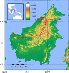
English: Relief (hypsometric) map of Borneo. Red lines represent national borders between Indonesia (south), Malaysia (north), and Brunei (top north). Created with GMT from publicly released GLOBE data[1]. For locator version, see File:Borneo Locator Topography.png.
Français : Carte du relief de l'île de Borneo. Les lignes rouges représentent les frontières séparant les états se partageant l'île de Bornéo : L'Indonésie (au sud), la Malaisie (au nord de l'Indonésie) et l'état de Bruneï (au nord de la Malaisie). Image produite à l'aide de la suite logicielle GMT à partir des données publiques GLOBE. Une version locator est disponible.
Tarix
Mənbə
Öz işi
Müəllif
Sadalmelik
Valued image
This image has been assessed under the valued image criteria and is considered the most valued image on Commons within the scope: Hypsometric map of Borneo. You can see its nomination here.
Lisenziya
Public domainPublic domainfalsefalse
Captions
Add a one-line explanation of what this file represents
{{Information |Description=Topographical map of Borneo. Created with GMT from publicly released GLOBE data[http://www.ngdc.noaa.gov/mgg/topo/globe.html]. |Source=self-made |Date=June 3, 2007 |Author= User:Sadalmelik }} Category:Maps of Malaysia
fayl, borneo, topography, fayl, faylın, tarixçəsi, fayl, keçidləri, faylın, qlobal, istifadəsisınaq, göstərişi, ölçüsü, piksel, digər, ölçülər, piksel, piksel, piksel, piksel, piksel, faylın, orijinalı, 8206, piksel, fayl, həcmi, mime, növü, image, fayl, vikim. Fayl Faylin tarixcesi Fayl kecidleri Faylin qlobal istifadesiSinaq gosterisi olcusu 567 600 piksel Diger olculer 227 240 piksel 454 480 piksel 726 768 piksel 968 1 024 piksel 1 725 1 824 piksel Faylin orijinali 8206 1 725 1 824 piksel fayl hecmi 2 52 MB MIME novu image png Bu fayl Vikimedia Commons dadirve diger layihelerde istifade edile biler Faylin tesvir sehifesine get Xulase IzahBorneo Topography png English Relief hypsometric map of Borneo Red lines represent national borders between Indonesia south Malaysia north and Brunei top north Created with GMT from publicly released GLOBE data 1 For locator version see File Borneo Locator Topography png Francais nbsp Carte du relief de l ile de Borneo Les lignes rouges representent les frontieres separant les etats se partageant l ile de Borneo nbsp L Indonesie au sud la Malaisie au nord de l Indonesie et l etat de Brunei au nord de la Malaisie Image produite a l aide de la suite logicielle GMT a partir des donnees publiques GLOBE Une version locator est disponible Tarix 3 iyun 2007 Menbe Oz isi Muellif Sadalmelik Valued imageThis image has been assessed under the valued image criteria and is considered the most valued image on Commons within the scope Hypsometric map of Borneo You can see its nomination here Lisenziya Public domain Public domain false false Men bu eserin muellif huquqlarinin sahibi kimi eseri ictimai mulkiyyete verirem Bu icaze butun dunyada quvvededir In some countries this may not be legally possible if so Bunun qanunla mumkun olmadigi hallarda Istenilen sexse istenilen meqsed ucun qanunlar terefinden qadagan edilmeyince hec bir sert qoymadan bu isden istifade haqqini bagislayiram CaptionsazerbaycancaAdd a one line explanation of what this file representsItems portrayed in this filetesvir ediryaradiciSome value without a Vikiverilenler itemWikimedia username nbsp ingilis SadalmelikURL nbsp ingilis https commons wikimedia org wiki user Sadalmelikmuellifin qisa adi Sadalmelikcopyright status nbsp ingiliscopyrighted dedicated to the public domain by copyright holder nbsp ingilislisenziyareleased into the public domain by the copyright holder nbsp ingilisCommons quality assessment nbsp ingilisWikimedia Commons valued image nbsp ingilisbaslama tarixi 7 may 2010yaranma tarixi3 iyun 2007source of file nbsp ingilisoriginal creation by uploader nbsp ingilis Faylin tarixcesi Faylin evvelki versiyasini gormek ucun gun tarix bolmesindeki tarixlere klikleyin Tarix VaxtKicik sekilOlculerIstifadeciSerh indiki19 17 1 sentyabr 20071 725 1 824 2 52 MB SadalmelikBetter data better colours 20 54 3 iyun 20072 083 2 158 1 67 MB Sadalmelik Information Description Topographical map of Borneo Created with GMT from publicly released GLOBE data http www ngdc noaa gov mgg topo globe html Source self made Date June 3 2007 Author User Sadalmelik Category Maps of Malaysia Fayl kecidleri Bu sekile olan kecidler Kalimantan Faylin qlobal istifadesi Bu fayl asagidaki vikilerde istifade olunur af wikipedia org layihesinde istifadesi Borneo ar wikipedia org layihesinde istifadesi الخطوط العريضة لماليزيا ban wikipedia org layihesinde istifadesi Nusa Kalimantan be tarask wikipedia org layihesinde istifadesi Kalimantan be wikipedia org layihesinde istifadesi Kalimantan bg wikipedia org layihesinde istifadesi Borneo bn wikipedia org layihesinde istifadesi ব র ন ও ca wikipedia org layihesinde istifadesi Hyalobagrus leiacanthus ceb wikipedia org layihesinde istifadesi Borneo Hyalobagrus leiacanthus de wikipedia org layihesinde istifadesi Borneo Batang Ai National Park de wikivoyage org layihesinde istifadesi Borneo de wiktionary org layihesinde istifadesi Borneo el wikipedia org layihesinde istifadesi Borneo el wiktionary org layihesinde istifadesi Borneo en wikipedia org layihesinde istifadesi Borneo East Malaysia Talk Borneo List of endemic birds of Borneo Outline of Malaysia User Chickstarr404 Gather lists 13386 A Travelers Alphabet by Stephen Runciman Wikipedia Today s featured list June 2021 Wikipedia Today s featured list June 11 2021 Wikipedia Main Page history 2021 June 11 Wikipedia Main Page history 2021 June 11b Phalaenopsis kapuasensis Phalaenopsis luteola Phalaenopsis modesta Phalaenopsis pantherina Phalaenopsis singuliflora User AryKun Misc Naval Base Borneo en wikibooks org layihesinde istifadesi Professionalism Michael de Guzman and the Bre X Scandal en wikinews org layihesinde istifadesi Category Borneo eo wikipedia org layihesinde istifadesi Borneo es wikipedia org layihesinde istifadesi Rio Kapuas Rio Mahakam et wikipedia org layihesinde istifadesi Kalimantan eu wikipedia org layihesinde istifadesi Hyalobagrus leiacanthus fa wikipedia org layihesinde istifadesi بورنئو fi wikipedia org layihesinde istifadesi Borneo fo wikipedia org layihesinde istifadesi Borneo frr wikipedia org layihesinde istifadesi Borneo fr wikipedia org layihesinde istifadesi Projet Charte graphique Domaine geographique Modele Infobox Ile Documentation Modele Infobox Ile Borneo gl wikipedia org layihesinde istifadesi Rio Kapuas hak wikipedia org layihesinde istifadesi Borneo Bu faylin qlobal istifadesine baxin Menbe https az wikipedia org wiki Fayl Borneo Topography png, wikipedia, oxu, kitab, kitabxana, axtar, tap, hersey,
ne axtarsan burda
, en yaxsi meqale sayti, meqaleler, kitablar, oyrenmek, wiki, bilgi, tarix, seks, porno, indir, yukle, sex, azeri sex, azeri, seks yukle, sex yukle, izle, seks izle, porno izle, mobil seks, telefon ucun, chat, azeri chat, tanisliq, tanishliq, azeri tanishliq, sayt, medeni, medeni saytlar, chatlar, mekan, tanisliq mekani, mekanlari, yüklə, pulsuz, pulsuz yüklə, mp3, video, mp4, 3gp, jpg, jpeg, gif, png, şəkil, muisiqi, mahnı, kino, film, kitab, oyun, oyunlar.