Bu fayl "Vikimedia Commons"dadır və digər layihələrdə istifadə edilə bilər.
Faylın təsvir səhifəsinə get
Xülasə
İzahAtlantis map 1882 crop.jpg
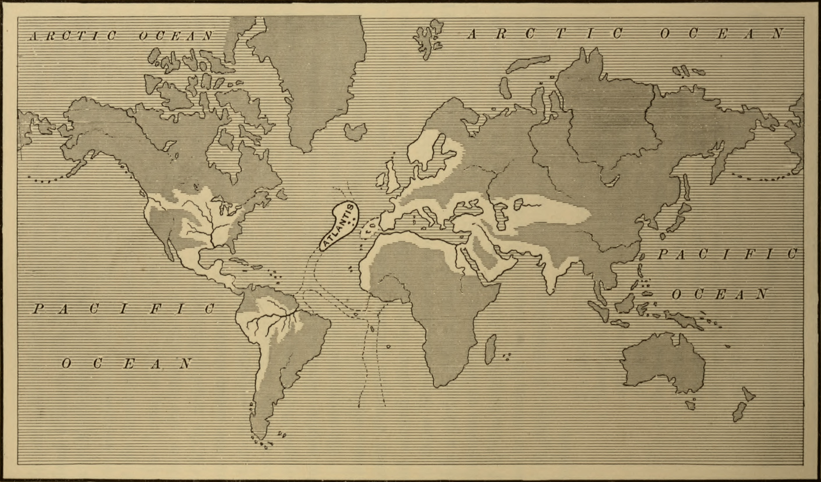
Map of the Atlantean Empire, from Ignatius Donelly's Atlantis: the Antediluvian World, 1882.
Tarix
Mənbə
This image is available from the United States Library of Congress's Prints and Photographs division under the digital ID cph.3b36915. This tag does not indicate the copyright status of the attached work. A normal copyright tag is still required. See Commons:Licensing for more information.
العربية ∙ беларуская (тарашкевіца) ∙ čeština ∙ Deutsch ∙ English ∙ español ∙ فارسی ∙ suomi ∙ français ∙ galego ∙ עברית ∙ magyar ∙ Bahasa Indonesia ∙ italiano ∙ 日本語 ∙ lietuvių ∙ македонски ∙ മലയാളം ∙ Nederlands ∙ polski ∙ português ∙ português do Brasil ∙ română ∙ русский ∙ sicilianu ∙ slovenčina ∙ slovenščina ∙ Türkçe ∙ українська ∙ 中文(简体) ∙ 中文(繁體) ∙ +/−
Müəllif
Ignatius Donnelly; cropped by Beyond My Ken (talk) 22:14, 28 September 2010 (UTC)
Digər versiyalar
This file has been extracted from another file
: Atlantis map 1882.jpg
Lisenziya
Public domainPublic domainfalsefalse
https://creativecommons.org/publicdomain/mark/1.0/PDMCreative Commons Public Domain Mark 1.0falsefalse
Captions
Add a one-line explanation of what this file represents
Items portrayed in this file
təsvir edir
yaranma tarixi
1882
Faylın tarixçəsi
Faylın əvvəlki versiyasını görmək üçün gün/tarix bölməsindəki tarixlərə klikləyin.
{{Information |Description=Map of the Atlantean Empire, from Ignatius Donelly's Atlantis: the Antediluvian World, 1882. |Source=Image from the Library of Congress, http://lcweb2.loc.gov/cgi-bin/query/D?ils:1:./temp/~pp_aA2u::@@@mdb=fsaall,app,brum,detr,s
Bu faylda fotoaparat və ya skanerlə əlavə olunmuş məlumatlar var. Əgər fayl sonradan redaktə olunubsa, bəzi parametrlər bu şəkildə göstərilənlərdən fərqli ola bilər.
Orientasiya
Normal
Üfüqi xətt
500 dpi
Şaquli xətt
500 dpi
Proqram təminatı
Adobe Photoshop 22.0 (Macintosh)
Faylın dəyişməsi tarixi və vaxtı
23:29, 4 noyabr 2020
Rəng sahəsi
sRGB
Tarix və vaxt rəqəmləşdirilir
00:08, 5 noyabr 2020
Date metadata was last modified
00:29, 5 noyabr 2020
Unique ID of original document
xmp.did:9e51323e-d234-48cb-b208-5f055248630c
Yanvar 14, 2023
fayl, atlantis, 1882, crop, fayl, faylın, tarixçəsi, istifadə, edilən, səhifələr, faylın, qlobal, istifadəsi, metaməlumatlarsınaq, göstərişi, ölçüsü, piksel, digər, ölçülər, piksel, piksel, piksel, piksel, piksel, faylın, orijinalı, 8206, piksel, fayl, həcmi, . Fayl Faylin tarixcesi Istifade edilen sehifeler Faylin qlobal istifadesi MetamelumatlarSinaq gosterisi olcusu 800 470 piksel Diger olculer 320 188 piksel 640 376 piksel 1 024 601 piksel 1 280 752 piksel 2 821 1 657 piksel Faylin orijinali 8206 2 821 1 657 piksel fayl hecmi 1 06 MB MIME novu image jpeg Bu fayl Vikimedia Commons dadirve diger layihelerde istifade edile biler Faylin tesvir sehifesine get Xulase IzahAtlantis map 1882 crop jpg Map of the Atlantean Empire from Ignatius Donelly s Atlantis the Antediluvian World 1882 Tarix 1882Menbe This image is available from the United States Library of Congress s Prints and Photographs division under the digital ID cph 3b36915 This tag does not indicate the copyright status of the attached work A normal copyright tag is still required See Commons Licensing for more information العربية belaruskaya tarashkevica cestina Deutsch English espanol فارسی suomi francais galego עברית magyar Bahasa Indonesia italiano 日本語 lietuviu makedonski മലയ ള Nederlands polski portugues portugues do Brasil romană russkij sicilianu slovencina slovenscina Turkce ukrayinska 中文 简体 中文 繁體 Muellif Ignatius Donnelly cropped by Beyond My Ken talk 22 14 28 September 2010 UTC Diger versiyalar This file has been extracted from another file Atlantis map 1882 jpg Lisenziya Public domain Public domain false falseThis work is in the public domain in its country of origin and other countries and areas where the copyright term is the author s life plus 70 years or fewer You must also include a United States public domain tag to indicate why this work is in the public domain in the United States Note that a few countries have copyright terms longer than 70 years Mexico has 100 years Jamaica has 95 years Colombia has 80 years and Guatemala and Samoa have 75 years This image may not be in the public domain in these countries which moreover do not implement the rule of the shorter term Cote d Ivoire has a general copyright term of 99 years and Honduras has 75 years but they do implement the rule of the shorter term Copyright may extend on works created by French who died for France in World War II more information Russians who served in the Eastern Front of World War II known as the Great Patriotic War in Russia and posthumously rehabilitated victims of Soviet repressions more information This file has been identified as being free of known restrictions under copyright law including all related and neighboring rights https creativecommons org publicdomain mark 1 0 PDM Creative Commons Public Domain Mark 1 0 false falseCaptionsazerbaycancaAdd a one line explanation of what this file representsItems portrayed in this filetesvir ediryaranma tarixi1882 Faylin tarixcesi Faylin evvelki versiyasini gormek ucun gun tarix bolmesindeki tarixlere klikleyin Tarix VaxtKicik sekilOlculerIstifadeciSerh indiki22 29 4 noyabr 20202 821 1 657 1 06 MB Sette quattrohigher quality 22 14 28 sentyabr 2010595 330 52 KB Beyond My Ken Information Description Map of the Atlantean Empire from Ignatius Donelly 039 s Atlantis the Antediluvian World 1882 Source Image from the Library of Congress http lcweb2 loc gov cgi bin query D ils 1 temp pp aA2u mdb fsaall app brum detr s Istifade edilen sehifeler Bu sekile olan kecidler Atlantida Faylin qlobal istifadesi Bu fayl asagidaki vikilerde istifade olunur ar wikiversity org layihesinde istifadesi أطلانطس ast wikipedia org layihesinde istifadesi Atlantida en wikipedia org layihesinde istifadesi Atlantis Location hypotheses of Atlantis he wikipedia org layihesinde istifadesi אטלנטיס ia wikipedia org layihesinde istifadesi Atlantida id wikipedia org layihesinde istifadesi Hipotesis lokasi Atlantis ja wikipedia org layihesinde istifadesi アトランティス my wikipedia org layihesinde istifadesi အတ တလန တစ မ တ pt wikipedia org layihesinde istifadesi Atlantida uk wikipedia org layihesinde istifadesi Atlantida www wikidata org layihesinde istifadesi Q25373Metamelumatlar Bu faylda fotoaparat ve ya skanerle elave olunmus melumatlar var Eger fayl sonradan redakte olunubsa bezi parametrler bu sekilde gosterilenlerden ferqli ola biler OrientasiyaNormalUfuqi xett500 dpiSaquli xett500 dpiProqram teminatiAdobe Photoshop 22 0 Macintosh Faylin deyismesi tarixi ve vaxti23 29 4 noyabr 2020Reng sahesisRGBTarix ve vaxt reqemlesdirilir00 08 5 noyabr 2020Date metadata was last modified00 29 5 noyabr 2020Unique ID of original documentxmp did 9e51323e d234 48cb b208 5f055248630c Menbe https az wikipedia org wiki Fayl Atlantis map 1882 crop jpg, wikipedia, oxu, kitab, kitabxana, axtar, tap, hersey,
ne axtarsan burda
, en yaxsi meqale sayti, meqaleler, kitablar, oyrenmek, wiki, bilgi, tarix, seks, porno, indir, yukle, sex, azeri sex, azeri, seks yukle, sex yukle, izle, seks izle, porno izle, mobil seks, telefon ucun, chat, azeri chat, tanisliq, tanishliq, azeri tanishliq, sayt, medeni, medeni saytlar, chatlar, mekan, tanisliq mekani, mekanlari, yüklə, pulsuz, pulsuz yüklə, mp3, video, mp4, 3gp, jpg, jpeg, gif, png, şəkil, muisiqi, mahnı, kino, film, kitab, oyun, oyunlar.