Bu fayl "Vikimedia Commons"dadır və digər layihələrdə istifadə edilə bilər.
təsvir səhifəsi
Faylın təsvir səhifəsinə get
Xülasə
İzahTopographic map of Greenland bedrock.jpg
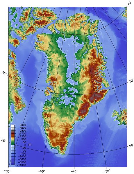
English: Topographic map of Greenland bedrock, in effect showing the topography without the extant ice sheet. Created using ETOPO1 Global Relief Model bedrock version from [1].
Mənbə
Öz işi
Müəllif
Skew-t
This map image could be re-created using vector graphics as an SVG file. This has several advantages; see Commons:Media for cleanup for more information. If an SVG form of this image is available, please upload it and afterwards replace this template with {{vector version available|new image name}}. It is recommended to name the SVG file "Topographic map of Greenland bedrock.svg" – then the template Vector version available (or Vva) does not need the new image name parameter.
This map image was uploaded in the JPEG format even though it consists of non-photographic data. This information could be stored more efficiently or accurately in the PNG or SVG format. If possible, please upload a PNG or SVG version of this image without compression artifacts, derived from a non-JPEG source (or with existing artifacts removed). After doing so, please tag the JPEG version with {{Superseded|NewImage.ext}} and remove this tag. This tag should not be applied to photographs or scans. If this image is a diagram or other image suitable for vectorisation, please tag this image with {{Convert to SVG}} instead of {{BadJPEG}}. If not suitable for vectorisation, use {{Convert to PNG}}. For more information, see {{BadJPEG}}.
Lisenziya
I, the copyright holder of this work, hereby publish it under the following license:
Bu fayl Creative Commons Attribution-Share Alike 3.0 Sinqapur lisenziyası altında yayımlanır.
Azadsınız:
paylaşmaq – əsəri köçürmək, paylamaq və ötürmək üçün
remiks etmək – əsəri adaptasiya etmək
Aşağıdakı şərtlərə riayət etməklə:
istinad – Müvafiq kredit verməlisiniz, lisenziyaya bir keçid verməlisiniz və dəyişikliklərin olub olmadığını bildirməlisiniz. Bunu hər hansı bir ağlabatan şəkildə edə bilərsiniz, ancaq lisenziyalaşdırıcının sizi və ya istifadənizi təsdiqləməsini təklif edən bir şəkildə deyil.
bənzər paylaşma – Əsəri remix edirsinizsə, dəyişdirirsinizsə və ya üzərində iş aparırsınızsa, öz töhfələrinizi orijinalda olduğu kimi eyni və ya uyğun lisenziya altında yayımlamalısınız.
{{Information |Description={{en|1=Topographic map of Greenland bedrock, in effect showing the topography without the extant ice sheet. Created using ETOPO1 Global Relief Model bedrock version from [http://www.ngdc.noaa.gov/mgg/global/global.html].}} |Sour
Bu faylda fotoaparat və ya skanerlə əlavə olunmuş məlumatlar var. Əgər fayl sonradan redaktə olunubsa, bəzi parametrlər bu şəkildə göstərilənlərdən fərqli ola bilər.
_error
0
September 25, 2023
fayl, topographic, greenland, bedrock, fayl, faylın, tarixçəsi, fayl, keçidləri, faylın, qlobal, istifadəsi, metaməlumatlarsınaq, göstərişi, ölçüsü, piksel, digər, ölçülər, piksel, piksel, piksel, faylın, orijinalı, 8206, piksel, fayl, həcmi, mime, növü, image. Fayl Faylin tarixcesi Fayl kecidleri Faylin qlobal istifadesi MetamelumatlarSinaq gosterisi olcusu 461 599 piksel Diger olculer 185 240 piksel 369 480 piksel 802 1 042 piksel Faylin orijinali 8206 802 1 042 piksel fayl hecmi 267 KB MIME novu image jpeg Bu fayl Vikimedia Commons dadirve diger layihelerde istifade edile biler tesvir sehifesi Faylin tesvir sehifesine get Xulase IzahTopographic map of Greenland bedrock jpg English Topographic map of Greenland bedrock in effect showing the topography without the extant ice sheet Created using ETOPO1 Global Relief Model bedrock version from 1 Menbe Oz isi Muellif Skew t This map image could be re created using vector graphics as an SVG file This has several advantages see nbsp Commons Media for cleanup for more information If nbsp an nbsp SVG nbsp form nbsp of nbsp this nbsp image is available please upload it and afterwards replace this template with vector version available i new image name i It is recommended to name the SVG file Topographic map of Greenland bedrock svg then the template Vector version available or Vva does not need the new image name parameter This map image was uploaded in the JPEG format even though it consists of non photographic data This information could be stored more efficiently or accurately in the PNG or SVG format If possible please upload a PNG or SVG version of this image without compression artifacts derived from a non JPEG source or with existing artifacts removed After doing so please tag the JPEG version with Superseded NewImage ext and remove this tag This tag should not be applied to photographs or scans If this image is a diagram or other image suitable for vectorisation please tag this image with Convert to SVG instead of BadJPEG If not suitable for vectorisation use Convert to PNG For more information see BadJPEG Lisenziya I the copyright holder of this work hereby publish it under the following license Bu fayl Creative Commons Attribution Share Alike 3 0 Sinqapur lisenziyasi altinda yayimlanir Azadsiniz paylasmaq eseri kocurmek paylamaq ve oturmek ucun remiks etmek eseri adaptasiya etmek Asagidaki sertlere riayet etmekle istinad Muvafiq kredit vermelisiniz lisenziyaya bir kecid vermelisiniz ve deyisikliklerin olub olmadigini bildirmelisiniz Bunu her hansi bir aglabatan sekilde ede bilersiniz ancaq lisenziyalasdiricinin sizi ve ya istifadenizi tesdiqlemesini teklif eden bir sekilde deyil benzer paylasma Eseri remix edirsinizse deyisdirirsinizse ve ya uzerinde is aparirsinizsa oz tohfelerinizi orijinalda oldugu kimi eyni ve ya uygun lisenziya altinda yayimlamalisiniz https creativecommons org licenses by sa 3 0 CC BY SA 3 0 Creative Commons Attribution Share Alike 3 0 true trueCaptionsazerbaycancaAdd a one line explanation of what this file representsItems portrayed in this filetesvir edircografi xeriteQrenlandiyayaradicisome valueURL https commons wikimedia org wiki user Skew tWikimedia username nbsp ingilis Skew tmuellifin qisa adi Skew tcopyright status nbsp ingiliscopyrighted nbsp ingilislisenziyaCreative Commons Attribution ShareAlike 3 0 Unported nbsp ingilissource of file nbsp ingilisoriginal creation by uploader nbsp ingilis Faylin tarixcesi Faylin evvelki versiyasini gormek ucun gun tarix bolmesindeki tarixlere klikleyin Tarix VaxtKicik sekilOlculerIstifadeciSerh indiki16 19 25 may 2010802 1 042 267 KB Skew t Information Description en 1 Topographic map of Greenland bedrock in effect showing the topography without the extant ice sheet Created using ETOPO1 Global Relief Model bedrock version from http www ngdc noaa gov mgg global global html Sour Fayl kecidleri Bu sekile olan kecidler Qrenlandiya adasi Faylin qlobal istifadesi Bu fayl asagidaki vikilerde istifade olunur af wikipedia org layihesinde istifadesi Groenland ar wikipedia org layihesinde istifadesi جغرافيا جرينلاند ba wikipedia org layihesinde istifadesi Grenlandiya be tarask wikipedia org layihesinde istifadesi Grenlyandyya vostray be wikipedia org layihesinde istifadesi Grenlandyya vostray bg wikipedia org layihesinde istifadesi Grenlandiya Grenlandiya ostrov ca wikipedia org layihesinde istifadesi Groenlandia cs wikipedia org layihesinde istifadesi Gronsko da wikipedia org layihesinde istifadesi Gronland Gronlands Grand Canyon Gronlands geologi de wikipedia org layihesinde istifadesi Gronland Eiszeitalter Gronlandischer Eisschild en wikipedia org layihesinde istifadesi Greenland Geography of Greenland Isostatic depression Climate of Greenland List of rivers of Greenland Talk Petermann Glacier User Skew t Gallery Talk Greenland Archive 2 Grand Canyon Greenland en wikibooks org layihesinde istifadesi Historical Geology Ice ages en wikiversity org layihesinde istifadesi Continental shelves North east American Continental shelves Arctic es wikipedia org layihesinde istifadesi Groenlandia fa wikipedia org layihesinde istifadesi فرورفتگی ترازایستایی fi wikipedia org layihesinde istifadesi Gronlannin suuri kanjoni fr wikipedia org layihesinde istifadesi Inlandsis du Groenland Grand Canyon du Groenland hy wikipedia org layihesinde istifadesi Գրենլանդիա կղզի Գրենլանդական սառցե վահան id wikipedia org layihesinde istifadesi Daftar sungai di Greenland ja wikipedia org layihesinde istifadesi グランドキャニオン グリーンランド ko wikipedia org layihesinde istifadesi 그랜드 캐니언 그린란드 nl wikipedia org layihesinde istifadesi Thule fictief land Groenlandse ijskap no wikipedia org layihesinde istifadesi Gronlands Grand Canyon Gronlandsisen pl wikipedia org layihesinde istifadesi Geografia Grenlandii Wyspy Grenlandii Ladolod grenlandzki ru wikipedia org layihesinde istifadesi Grenlandskij ledyanoj shit Grenlandiya simple wikipedia org layihesinde istifadesi Greenland ta wikipedia org layihesinde istifadesi க ர ன ல ந த பன ப பக த trv wikipedia org layihesinde istifadesi Greenland uk wikipedia org layihesinde istifadesi Grenlandskij lodovikovij shit Bu faylin qlobal istifadesine baxin Metamelumatlar Bu faylda fotoaparat ve ya skanerle elave olunmus melumatlar var Eger fayl sonradan redakte olunubsa bezi parametrler bu sekilde gosterilenlerden ferqli ola biler error0 Menbe https az wikipedia org wiki Fayl Topographic map of Greenland bedrock jpg, wikipedia, oxu, kitab, kitabxana, axtar, tap, hersey,
ne axtarsan burda
, en yaxsi meqale sayti, meqaleler, kitablar, oyrenmek, wiki, bilgi, tarix, seks, porno, indir, yukle, sex, azeri sex, azeri, seks yukle, sex yukle, izle, seks izle, porno izle, mobil seks, telefon ucun, chat, azeri chat, tanisliq, tanishliq, azeri tanishliq, sayt, medeni, medeni saytlar, chatlar, mekan, tanisliq mekani, mekanlari, yüklə, pulsuz, pulsuz yüklə, mp3, video, mp4, 3gp, jpg, jpeg, gif, png, şəkil, muisiqi, mahnı, kino, film, kitab, oyun, oyunlar.