Bu fayl "Vikimedia Commons"dadır və digər layihələrdə istifadə edilə bilər.
Faylın təsvir səhifəsinə get
Xülasə
This historical map image could be re-created using vector graphics as an SVG file. This has several advantages; see Commons:Media for cleanup for more information. If an SVG form of this image is available, please upload it and afterwards replace this template with {{vector version available|new image name}}. It is recommended to name the SVG file "Portugal Império total.svg" – then the template Vector version available (or Vva) does not need the new image name parameter.
Xülasə
İzahPortugal Império total.png
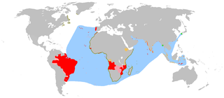
English: An anachronous map of the Portuguese Empire (1415-1999).
Red - actual possessions
Olive green - explorations
Orange - areas of influence and trade
Pink - claims of sovereignty
Light green - trading posts
Blue - main sea explorations, routes and areas of influence.
Português: Mapa anacrónico do Império Português (1415-1999).
Vermelho - possessões efetivas
Verde Oliva - explorações
Laranja - áreas de influência e comércio
Rosa - reivindicações de soberania
Verde claro - postos comerciais
Azul - principais explorações marinhas, rotas e áreas de influência.
Deutsch: Anachronistische Karte des Portugiesischen Weltreichs (1415-1999)
Rot - tatsächliche Besitzungen
Olive - Entdeckungen
Orange - Einfluss- und Handelsgebiete
Rosa - Besitzansprüche
Grün - Handelsposten
Blau - Hauptentdeckungen, Routen und Einflussgebiete zur See
Español: Mapa anacrónico del imperio portugués (1415-1999).
Rojo - posesiones reales
Oliva - exploraciones
Naranja - áreas de influencia y comercio
Rosa - reclamaciones de soberanía
Verde - puertos comerciales
Azul - principales exploraciones marinas, rutas y áreas de influencia.
Français : Carte anachronique de l'empire colonial portugais (1415-1999).
Rouge - possessions réelles
Olive - explorations
Orange - aire d'influence et de commerce
Rose - territoires revendiqués
Vert - comptoirs commerciaux
Bleu - principales explorations, routes commerciales et aires d'influence maritimes.
Polski: Anachroniczna mapa Imperium Portugalskiego (1415-1999).
Kolory:
czerwony - faktyczne władanie
oliwkowy - zasięg odkryć
pomarańczowy - obszary wpływów i handlu
różowy - roszczenia do suwerenności
zielony - faktorie (ośrodki handlowe)
niebieski - główne morskie obszary odkryć, tras i wpływów.
தமிழ்: போர்த்துகீசிய பேரரசு (1415-1999) காலத்திற்கு ஒவ்வாத வரைபடம்
நிறங்கள்
சிவப்பு - உடைமை
ஆலிவ் - ஆராய்ந்தவை
காவி - வணிகம் மற்றும் செல்வாக்கு மிகுந்த இடங்கள்
இளஞ்சிவப்பு - இறையாண்மை கூற்றுக்கள்
பச்சை - வர்த்தக பதிவுகள்
நீலம் - பிரதான கடல் கண்டுபிடிப்புகள், செல்வாக்கு பகுதிகள்
Bahasa Indonesia: Sebuah peta anakron dari Kekaisaran Portugis (1415-1999).
Merah - kepemilikan sebenarnya
Hijau zaitun - penjelajahan
Oranye - wilayah pengaruh dan perdagangan
Merah muda - klaim kedaulatan
Hijau muda - pos dagang
Biru - penjelajahan laut utama, rute dan wilayah pengaruh
Category:World maps
Tarix
30 mart 2007 (original upload date)
Mənbə
Transferred from en.wikipedia to Commons.
Müəllif
The Ogre at ingilis Vikipediya / Later versions were uploaded by The Red Hat of Pat Ferrick at ingilis Vikipediya.
Digər versiyalar
Derivative works of this file: Portuguese Empire 1415-1999.png
Additional Information and Sources
This map is a comprehensive geographical anachronous representation of all the actual possessions of the en:Portuguese Empire.
Claims of sovereignty
en:Canary Islands
en:Pink Map
en:Brazil
Areas of discovery
(European discoveries were usually accompanied by ceremonies claiming the newly discovered lands for the monarch in whose name the voyage was made, even if those claims were not followed up by actual colonisation).
en:Greenland: (1499/1500–?) possession claimed by João Fernandes Labrador in 1499 or 1500. Seen as claimed in the Cantino planisphere of 1502, Reinel-Lopo Homem chart of 1519 and Reinel map of 1535.
Land of the Corte-Real: (1501–?) claimed after the voyages of the Corte-Real brothers.
Terra Nova (Newfoundland): (1501–?) claimed by Miguel and Gaspar Corte-Real, latter by João Álvares Fagundes. Also known as Terra Nova dos Bacalhaus.
en:Labrador (1499/1500–?): claimed by the Corte-Real brothers and maybe by João Fernandes Labrador.
en:Nova Scotia (1519?–?): explored and claimed by João Álvares Fagundes.
African coastline
Trading posts
Timisoara gabriel
Areas of influence
Actual posessions
In Africa
Portuguese presence in en:Africa started in 1415 with the conquest of en:Ceuta and is generally view as ending in 1975, with the independence of its later colonies, although the present autonomous region of en:Madeira located in the en:African Plate, some 650 km (360 mi) off the en:North African coast, Madeira belongs and has always belonged ethnically, culturally, economically and politically to en:Europe, some 955 km (583 mi) from the European mainland.
Angola/Portuguese West Africa: colony (1575–1589); crown colony (1589–1951); overseas province (1951–1971); state (1971–1975). Independence in 1975.
en:Arguin/Arguim: (1455–1633)
en:Accra: (1557–1578)
Cabinda: protectorate (1883–1885)Frente de Libertação do Estado de Cabinda (F.L.E.C). Congo district (1887–1921); intendancy subordinate to en:Maquela (1921–1922); dependency of Zaire district (1922–1930); Intendacy of Zaire and Cabinda (1930–1932); intendancy under en:Angola (1932–1934); dependency under Angola (1934–1945); restored as District (1946–1975). Controlled by Frente Nacional para a Libertação de Angola (en:National Liberation Front of Angola) as part of independent Angola in 1975. Declared Cabinda a Republic in 1975, but not recognized by Portugal nor Angola.
Cabo Verde/Cape Verde: settlements (1462–1495); dominion of crown colonies (1495–1587); crown colony (1587–1951); overseas province (1951–1974); en:autonomous republic (1974–1975). Independence in 1975.
en:Ceuta: possession (1415–1640). Became Spanish in 1668.
en:Elmina: possession (1482–1637)
Fernando Poo and en:Annobón: colonies (1474–1778). Ceded to Spain in 1778.
en:Portuguese Gold Coast: (1482–1642), ceded to Dutch Gold Coast in 1642
Guiné Portuguesa/Portuguese Guinea: colony (1879–1951); overseas province (1951–1974). Unilateral independence declared in 1973, recognized by Portugal in 1974.
en:Cacheu: captaincy (1640–1879). United with Bissau in 1879.
en:Bissau: settlement under Cacheu (1687–1696); captaincy (1696–1707); abandoned (1707–1753); separate colony under Cape Verde (1753–1879). United with Cacheu in 1879.
en:Madagascar: southern part (1496–1550)
en:Madeira: possession (1418–1420); colony (1420–1580); crown colony (1580–1834); autonomous district (1834–1976). Made an autonomous region in 1976.
en:Mascarene Islands: fortified post (1498–1540)
en:Malindi: occupation (1500–1630)
en:Mombassa: occupation (1593–1638); colony subordinate to Goa (1638–1698; 1728–1729). Under Omani sovereignty in 1729.
en:Morocco en:enclaves
Aguz/en:Soueira Kedima (1506–1525)
en:Tânger/Tanjah (1471–1661). Ceded to en:England in 1662.
en:Alcácer Ceguer/El Qsar es Seghir (1458–1550)
en:Arzila/en:Asilah (1471–1550; 1577–1589). Conquest by Saady in 1589.
en:Azamor/Azemmour (1513–1541). Conquest by Saady in 1541.
en:Mazagão/El Jadida (1485–1550); possession (1506–1769). Anexed by Morocco in 1769.
en:Mogador/Essaouira (1506–1510)
Safim/Safi (1488–1541) Conquest by Saady
Santa Cruz do Cabo de Gué/en:Agadir (1505–1541) Conquest by Saady
Mozambique/Portuguese East Africa: possession (1498–1501); subordinate to Goa (1501–1569); captaincy-general (1569–1609); colony subordinate to Goa (1609–1752); colony (1752–1951); overseas province (1951–1971); state (1971–1974); local transitional administration (1974–1975). Independence in 1975.
Quíloa (1505–1512)
en:Saint Laurent Islands (Madagascar): fortified post (1498–1540)
en:São João Baptista de Ajudá: fort subordinate to Brazil (1721–1730); subordinate to São Tomé e Príncipe (1865–1869). Annexed by Dahomey in 1961.
São Tomé e Príncipe: crown colony (1753–1951); overseas province (1951–1971); local administration (1971–1975). Independence in 1975.
en:São Tomé: possession (1470–1485); colony (1485–1522); crown colony (1522–1641); administration under Dutch occupation (1641–1648). French occupation in 1648.
en:Príncipe: colony (1500–1573). United with São Tomé in 1573.
en:Zanzibar: possession (1503–1698). Became part of en:Oman in 1698.
en:Ziguinchor: possession (1645–1888). Ceded to en:France in 1888.
North Atlantic and North America
The Azores were discovered soon in the Discovery Ages. Labrador and Corte-Real brothers later explored and claimed Greenland and eastern modern Canada from 1499 to 1502.
en:Azores: colonies (1427–1766); captaincy-general (1766–1831); autonomous districts of en:Angra do Heroismo, en:Horta and en:Ponta Delgada (1831–1976). Made an autonomous region in 1976.
In Central and South America
Brazil was explored and claimed in 1500, and become independent in 1822. Unlike the Spanish, the Portuguese did not divide its possession in South America in several vice-royalties.
en:Barbados: Possession known as Os Barbados, discovered by Pedro Campos in 1536 being an exile post for Brazilian Jews. The only Caribbean possession the Portuguese held for eighty-four years until Portugal abandoned the island to continue exploring nearby Brazil.
en:Brazil: possession known as Ilha de Santa Cruz, later Terra de Vera Cruz (1500–1530); colony (1530-1714); vice-kingdom (1714–1815); kingdom under United Kingdom of Portugal (1815–1822), independence in 1822.
Cisplatina (Uruguay): occupation (1808–1822). Captaincy in 1817 (of the United Kingdom of Portugal, Brazil and Algarves). Adhered as a province of the new en:Empire of Brazil in 1822. Became independent 1827, changing its name to Uruguay.
en:French Guiana: occupation (1809–1817). Restored to en:France in 1817.
Nova Colônia do Sacramento: colony in present Uruguay (1680; 1683–1705; 1715–1777). Ceded to Spain in 1777.
In Asia and Oceania
Reached by the Portuguese in 1498 by en:Vasco da Gama. Macau was the last possession in Asia and was handed over to the People's Republic of China in 1999.
en:Aden: possession (failed in 1510;1516-1538)
en:Bahrain: possession (1521–1602)
Ceylon: colony (1597–1658). Dutch took control in 1656, en:Jaffna taken in 1658.
Flores Island: possession (16th-19th century)
en:Solor: possession (1520-1636)
Gamru/en:Bandar Abbas: possession (1506–1615)
en:Hormuz/Ormuz: possession subordinate to Goa (1515–1622). Incorporated into Persia in 1622.
Laccadive Islands (1498–1545)
en:Macau/Macao: settlement (1553–1557), leased territory subordinated to Goa (1557–1844); overseas province (1844–1883); combined overseas province with Timor-Leste under Goa (1883–1951); overseas province (1951–1976); Chinese territory under Portuguese administration (1976–1999). Returned to full sovereignty of People's Republic of China as a en:special administrative region in 1999.
en:Coloane: occupation in 1864
en:Taipa: occupation in 1851
en:Ilha Verde: incorporated in 1890
D. João, Lapa and Montanha Islands: settled by Portuguese missionaries in the XIX century; occupation by Portuguese troops in 1938. Taken in 1941 by the en:Empire of Japan and restored to China in 1945.
en:Makassar (1512–1665)
en:Malacca: settlement (1511–1641); lost to the Dutch
en:Maldives: possession (1518–1521, 1558–1573)
en:Moluccas
Amboina/Ambon: settlement (1576–1605)
en:Ternate: settlement (1522–1575)
en:Tidore: colony (1578–1605). Seized by Dutch in 1605.
Muscat: possession (1515–1650)
Índia Portuguesa/Portuguese India: overseas province (1946–1962). Taken over by India in 1962 and recognised by Portugal in 1974.
Baçaim/en:Vasai: possession (1535–1739)
en:Bombay/en:Mumbai: possession (1534–1661)
en:Calicut/en:Kozhikode: settlement (1512–1525)
en:Cambay/en:Khambhat: possession
en:Cannanore: possession (1502–1663)
en:Chaul: possession (1521–1740)
en:Chittagong: possession (1528–1666)
Cochin: possession (1500–1663)
en:Cranganore: possession (1536–1662)
Damão/Daman: acquisition in 1559. Became part of overseas province in 1946. Retaken over by India in Dec 1961.
Diu: acquisition in 1535. Became part of overseas province in 1946. Retaken over by India in Dec 1961.
en:Dadra: acquisition in 1779. Retaken over by India in 1954.
en:Goa: colony (1510–1946). Became part of overseas province in 1946. Retaken over by India in Dec 1961.
en:Hughli: possession (1579–1632)
Nagar Haveli: acquisition in 1779. Retaken over by India in 1954.
Masulipatnam (1598–1610)
en:Mangalore (1568–1659)
en:Negapatam/en:Nagapattinam (1507–1657)
Paliacate (1518–1610). occupied by the Dutch in 1610.
Coulão/en:Quilon: possession (1502–1661)
en:Salsette Island: possession (1534–1737). conquered by the en:Marathas.
en:São Tomé de Meliapore: settlement (1523–1662; 1687–1749)
en:Surat: settlement (1540–1612)
en:Tuticorin/en:Thoothukudi (1548–1658)
en:Socotra: possession (1506–1511). Became part of Mahri en:Sultanate of Qishn and Suqutra
en:Timor: claimed and partially possessed from 1520 to 1640.
en:West Timor: part of Timor lost to the Dutch in 1640.
en:East Timor: colony subordinate to Portuguese India (1642–1844); subordinate to Macau (1844–1896); separate colony (1896–1951); overseas territory (1951–1975); republic and unilateral independence proclaimed, annexed by Indonesia (1975–1999, UN recognition as Portuguese territory). UN administration from 1999 until independence in 2002.
2007-04-15 13:11 The Ogre 1425×625×8 (44415 bytes) rm question smarks in North America as per talk in [[Talk:Portuguese_Empire#An_exploration_.3D_Empire.3F|Talk:Portuguese Empire # An exploration = Empire?]]
2007-04-09 20:29 The Ogre 1425×625×8 (44551 bytes) An anachronous map of the [[Portuguese Empire]] (1415-1999). Red - actual possessions; Pink - explorations, areas of influence and claims of sovereignty; Blue - main sea explorations, routes and areas of inluence.
2007-04-03 23:35 The Red Hat of Pat Ferrick 1425×625×8 (29727 bytes) Removed Australia as per talk page.
2007-04-03 15:20 The Ogre 1425×625×8 (44746 bytes) I made this, again and again... It´s a work in progress! Just corrected the color (red to Pink) for the [[Banda Islands]]
2007-03-31 16:02 The Ogre 1425×625×8 (44736 bytes) Again me, some minor tweaks.
2007-03-31 12:59 The Ogre 1425×625×8 (43961 bytes) I made this, once more! Adding Portuguese area of influence in the [[Kingdom of Kongo]]
2007-03-30 17:55 The Ogre 1425×625×8 (43701 bytes) I made this, again!
2007-03-30 17:42 The Ogre 1425×625×8 (43664 bytes) I made this!
Lisenziya
Bu əsərin müəllif hüquqlarının sahibi əsəri məhdudiyyətsiz paylaşma, ticari istifadə və əsərdə dəyişiklik etmək də daxil olmaqla əsərdən hər kəsin istənilən məqsədlə istifadə etməsinə icazə verir.
Qeyd: Əgər bu təsvirin müəllifli göstərilməyibsə, bu şablonun yerinə {{Attribution}} şablonundan istifadə edin. Əgər bu sizin şəxsi işinizdirsə, zəhmət olmasa,bu şablonun yerinə {{PD-self}} şablonundan istifadə edin.Copyrighted free use//commons.wikimedia.org/wiki/File:Portugal_Imp%C3%A9rio_total.png
References
Diffie, Bailey (1977) Foundations of the Portuguese Empire, 1415-1580, University of Minnesota Press ISBN: 0816607826.
Captions
Add a one-line explanation of what this file represents
Items portrayed in this file
təsvir edir
copyright status ingilis
copyrighted, dedicated to the public domain by copyright holder ingilis
lisenziya
released into the public domain by the copyright holder ingilis
copyrighted free use ingilis
yaranma tarixi
30 mart 2007
MIME type ingilis
image/png
Faylın tarixçəsi
Faylın əvvəlki versiyasını görmək üçün gün/tarix bölməsindəki tarixlərə klikləyin.
{{Information |Description=An anachronous map of the en:Portuguese Empire (1415-1999). Red - actual possessions; Pink - explorations, areas of influence and trade and claims of sovereignty; Blue - main sea explorations, routes and areas of inluence.
fayl, portugal, império, total, fayl, faylın, tarixçəsi, fayl, keçidləri, faylın, qlobal, istifadəsisınaq, göstərişi, ölçüsü, piksel, digər, ölçülər, piksel, piksel, piksel, faylın, orijinalı, 8206, piksel, fayl, həcmi, mime, növü, image, fayl, vikimedia, comm. Fayl Faylin tarixcesi Fayl kecidleri Faylin qlobal istifadesiSinaq gosterisi olcusu 800 351 piksel Diger olculer 320 140 piksel 640 281 piksel 1 425 625 piksel Faylin orijinali 8206 1 425 625 piksel fayl hecmi 29 KB MIME novu image png Bu fayl Vikimedia Commons dadirve diger layihelerde istifade edile biler Faylin tesvir sehifesine get Mundericat 1 Xulase 2 Xulase 3 Additional Information and Sources 3 1 Claims of sovereignty 3 2 Areas of discovery 3 3 Trading posts 3 4 Areas of influence 3 5 Actual posessions 3 5 1 In Africa 3 5 2 North Atlantic and North America 3 5 3 In Central and South America 3 5 4 In Asia and Oceania 3 6 References 4 Lisenziya 5 Orijinal yukleme gundeliyi 6 Lisenziya 7 References Xulase This historical map image could be re created using vector graphics as an SVG file This has several advantages see nbsp Commons Media for cleanup for more information If nbsp an nbsp SVG nbsp form nbsp of nbsp this nbsp image is available please upload it and afterwards replace this template with vector version available i new image name i It is recommended to name the SVG file Portugal Imperio total svg then the template Vector version available or Vva does not need the new image name parameter Xulase IzahPortugal Imperio total png English An anachronous map of the Portuguese Empire 1415 1999 Red actual possessions Olive green explorations Orange areas of influence and trade Pink claims of sovereignty Light green trading posts Blue main sea explorations routes and areas of influence Portugues Mapa anacronico do Imperio Portugues 1415 1999 Vermelho possessoes efetivas Verde Oliva exploracoes Laranja areas de influencia e comercio Rosa reivindicacoes de soberania Verde claro postos comerciais Azul principais exploracoes marinhas rotas e areas de influencia Deutsch Anachronistische Karte des Portugiesischen Weltreichs 1415 1999 Rot tatsachliche Besitzungen Olive Entdeckungen Orange Einfluss und Handelsgebiete Rosa Besitzanspruche Grun Handelsposten Blau Hauptentdeckungen Routen und Einflussgebiete zur See Espanol Mapa anacronico del imperio portugues 1415 1999 Rojo posesiones reales Oliva exploraciones Naranja areas de influencia y comercio Rosa reclamaciones de soberania Verde puertos comerciales Azul principales exploraciones marinas rutas y areas de influencia Francais nbsp Carte anachronique de l empire colonial portugais 1415 1999 Rouge possessions reelles Olive explorations Orange aire d influence et de commerce Rose territoires revendiques Vert comptoirs commerciaux Bleu principales explorations routes commerciales et aires d influence maritimes Italiano Carta anacronistica dell Impero Portoghese 1415 1999 Rosso possedimenti effettivi Verde Oliva esplorazioni Arancione aree d influenza e commercio Rosa territori rivendicati Verde basi commerciali Blu principali rotte commerciali esplorazioni e aree d influenza marittime Galego Mapa anacronico do imperio portugues 1415 1999 Vermello posesions actuais Oliva exploracions Laranxa areas de influencia e comercio Rosa reclamacions de soberania Verde portos comerciais Azul principais exploracions marinas rutas e areas de influencia 한국어 포르투갈 제국 1415 1999 의 연대를 무시한 영역 지도 빨강 실제 점유 영역 진녹 탐사 지역 주황 교역과 영향이 있던 지역 분홍 통치권이 주장되었던 지역 초록 무역 거점 파랑 중요 탐사 무역 및 영향력을 끼쳤던 해역 中文 时间交错的葡萄牙帝国 1415年 1999年 地图 红色代表实际占有领土 粉红色代表勘探地 贸易影响地区以及宣称占有的陆域 蓝色代表勘探海域 航海路线和影响力所及的海域 不包括有争议的澳大利亚的发现 Polski Anachroniczna mapa Imperium Portugalskiego 1415 1999 Kolory czerwony faktyczne wladanie oliwkowy zasieg odkryc pomaranczowy obszary wplywow i handlu rozowy roszczenia do suwerennosci zielony faktorie osrodki handlowe niebieski glowne morskie obszary odkryc tras i wplywow தம ழ ப ர த த க ச ய ப ரரச 1415 1999 க லத த ற க ஒவ வ த வர படம ந றங கள ச வப ப உட ம ஆல வ ஆர ய ந தவ க வ வண கம மற ற ம ச ல வ க க ம க ந த இடங கள இளஞ ச வப ப இற ய ண ம க ற ற க கள பச ச வர த தக பத வ கள ந லம ப ரத ன கடல கண ட ப ட ப ப கள ச ல வ க க பக த கள Bahasa Indonesia Sebuah peta anakron dari Kekaisaran Portugis 1415 1999 Merah kepemilikan sebenarnya Hijau zaitun penjelajahan Oranye wilayah pengaruh dan perdagangan Merah muda klaim kedaulatan Hijau muda pos dagang Biru penjelajahan laut utama rute dan wilayah pengaruh Category World maps Tarix 30 mart 2007 original upload date Menbe Transferred from en wikipedia to Commons Muellif The Ogre at ingilis Vikipediya Later versions were uploaded by The Red Hat of Pat Ferrick at ingilis Vikipediya Diger versiyalar Derivative works of this file nbsp Portuguese Empire 1415 1999 png Additional Information and Sources This map is a comprehensive geographical anachronous representation of all the actual possessions of the en Portuguese Empire Claims of sovereignty en Canary Islands 1 en Pink Map 2 en Brazil Areas of discovery European discoveries were usually accompanied by ceremonies claiming the newly discovered lands for the monarch in whose name the voyage was made even if those claims were not followed up by actual colonisation en Greenland 1499 1500 possession claimed by Joao Fernandes Labrador in 1499 or 1500 Seen as claimed in the Cantino planisphere of 1502 Reinel Lopo Homem chart of 1519 and Reinel map of 1535 Land of the Corte Real 1501 claimed after the voyages of the Corte Real brothers Terra Nova Newfoundland 1501 claimed by Miguel and Gaspar Corte Real latter by Joao Alvares Fagundes Also known as Terra Nova dos Bacalhaus en Labrador 1499 1500 claimed by the Corte Real brothers and maybe by Joao Fernandes Labrador en Nova Scotia 1519 explored and claimed by Joao Alvares Fagundes African coastline Trading posts Timisoara gabriel Areas of influence Actual posessions In Africa Portuguese presence in en Africa started in 1415 with the conquest of en Ceuta and is generally view as ending in 1975 with the independence of its later colonies although the present autonomous region of en Madeira located in the en African Plate some 650 nbsp km 360 nbsp mi off the en North African coast Madeira belongs and has always belonged ethnically culturally economically and politically to en Europe some 955 nbsp km 583 nbsp mi from the European mainland Angola Portuguese West Africa colony 1575 1589 crown colony 1589 1951 overseas province 1951 1971 state 1971 1975 Independence in 1975 en Arguin Arguim 1455 1633 en Accra 1557 1578 Cabinda protectorate 1883 1885 Frente de Libertacao do Estado de Cabinda F L E C Congo district 1887 1921 intendancy subordinate to en Maquela 1921 1922 dependency of Zaire district 1922 1930 Intendacy of Zaire and Cabinda 1930 1932 intendancy under en Angola 1932 1934 dependency under Angola 1934 1945 restored as District 1946 1975 Controlled by Frente Nacional para a Libertacao de Angola en National Liberation Front of Angola as part of independent Angola in 1975 Declared Cabinda a Republic in 1975 but not recognized by Portugal nor Angola Cabo Verde Cape Verde settlements 1462 1495 dominion of crown colonies 1495 1587 crown colony 1587 1951 overseas province 1951 1974 en autonomous republic 1974 1975 Independence in 1975 en Ceuta possession 1415 1640 Became Spanish in 1668 en Elmina possession 1482 1637 Fernando Poo and en Annobon colonies 1474 1778 Ceded to Spain in 1778 en Portuguese Gold Coast 1482 1642 ceded to Dutch Gold Coast in 1642 Guine Portuguesa Portuguese Guinea colony 1879 1951 overseas province 1951 1974 Unilateral independence declared in 1973 recognized by Portugal in 1974 en Cacheu captaincy 1640 1879 United with Bissau in 1879 en Bissau settlement under Cacheu 1687 1696 captaincy 1696 1707 abandoned 1707 1753 separate colony under Cape Verde 1753 1879 United with Cacheu in 1879 en Madagascar southern part 1496 1550 en Madeira possession 1418 1420 colony 1420 1580 crown colony 1580 1834 autonomous district 1834 1976 Made an autonomous region in 1976 en Mascarene Islands fortified post 1498 1540 en Malindi occupation 1500 1630 en Mombassa occupation 1593 1638 colony subordinate to Goa 1638 1698 1728 1729 Under Omani sovereignty in 1729 en Morocco en enclaves Aguz en Soueira Kedima 1506 1525 en Tanger Tanjah 1471 1661 Ceded to en England in 1662 en Alcacer Ceguer El Qsar es Seghir 1458 1550 en Arzila en Asilah 1471 1550 1577 1589 Conquest by Saady in 1589 en Azamor Azemmour 1513 1541 Conquest by Saady in 1541 en Mazagao El Jadida 1485 1550 possession 1506 1769 Anexed by Morocco in 1769 en Mogador Essaouira 1506 1510 Safim Safi 1488 1541 Conquest by Saady Santa Cruz do Cabo de Gue en Agadir 1505 1541 Conquest by Saady Mozambique Portuguese East Africa possession 1498 1501 subordinate to Goa 1501 1569 captaincy general 1569 1609 colony subordinate to Goa 1609 1752 colony 1752 1951 overseas province 1951 1971 state 1971 1974 local transitional administration 1974 1975 Independence in 1975 Quiloa 1505 1512 en Saint Laurent Islands Madagascar fortified post 1498 1540 en Sao Joao Baptista de Ajuda fort subordinate to Brazil 1721 1730 subordinate to Sao Tome e Principe 1865 1869 Annexed by Dahomey in 1961 Sao Tome e Principe crown colony 1753 1951 overseas province 1951 1971 local administration 1971 1975 Independence in 1975 en Sao Tome possession 1470 1485 colony 1485 1522 crown colony 1522 1641 administration under Dutch occupation 1641 1648 French occupation in 1648 en Principe colony 1500 1573 United with Sao Tome in 1573 en Zanzibar possession 1503 1698 Became part of en Oman in 1698 en Ziguinchor possession 1645 1888 Ceded to en France in 1888 North Atlantic and North America The Azores were discovered soon in the Discovery Ages Labrador and Corte Real brothers later explored and claimed Greenland and eastern modern Canada from 1499 to 1502 en Azores colonies 1427 1766 captaincy general 1766 1831 autonomous districts of en Angra do Heroismo en Horta and en Ponta Delgada 1831 1976 Made an autonomous region in 1976 In Central and South America Brazil was explored and claimed in 1500 and become independent in 1822 Unlike the Spanish the Portuguese did not divide its possession in South America in several vice royalties en Barbados Possession known as Os Barbados discovered by Pedro Campos in 1536 being an exile post for Brazilian Jews The only Caribbean possession the Portuguese held for eighty four years until Portugal abandoned the island to continue exploring nearby Brazil en Brazil possession known as Ilha de Santa Cruz later Terra de Vera Cruz 1500 1530 colony 1530 1714 vice kingdom 1714 1815 kingdom under United Kingdom of Portugal 1815 1822 independence in 1822 Cisplatina Uruguay occupation 1808 1822 Captaincy in 1817 of the United Kingdom of Portugal Brazil and Algarves Adhered as a province of the new en Empire of Brazil in 1822 Became independent 1827 changing its name to Uruguay en French Guiana occupation 1809 1817 Restored to en France in 1817 Nova Colonia do Sacramento colony in present Uruguay 1680 1683 1705 1715 1777 Ceded to Spain in 1777 In Asia and Oceania Reached by the Portuguese in 1498 by en Vasco da Gama Macau was the last possession in Asia and was handed over to the People s Republic of China in 1999 en Aden possession failed in 1510 1516 1538 en Bahrain possession 1521 1602 Ceylon colony 1597 1658 Dutch took control in 1656 en Jaffna taken in 1658 Flores Island possession 16th 19th century en Solor possession 1520 1636 Gamru en Bandar Abbas possession 1506 1615 en Hormuz Ormuz possession subordinate to Goa 1515 1622 Incorporated into Persia in 1622 Laccadive Islands 1498 1545 en Macau Macao settlement 1553 1557 leased territory subordinated to Goa 1557 1844 overseas province 1844 1883 combined overseas province with Timor Leste under Goa 1883 1951 overseas province 1951 1976 Chinese territory under Portuguese administration 1976 1999 Returned to full sovereignty of People s Republic of China as a en special administrative region in 1999 en Coloane occupation in 1864 en Taipa occupation in 1851 en Ilha Verde incorporated in 1890 D Joao Lapa and Montanha Islands settled by Portuguese missionaries in the XIX century occupation by Portuguese troops in 1938 Taken in 1941 by the en Empire of Japan and restored to China in 1945 en Makassar 1512 1665 en Malacca settlement 1511 1641 lost to the Dutch en Maldives possession 1518 1521 1558 1573 en Moluccas Amboina Ambon settlement 1576 1605 en Ternate settlement 1522 1575 en Tidore colony 1578 1605 Seized by Dutch in 1605 Muscat possession 1515 1650 India Portuguesa Portuguese India overseas province 1946 1962 Taken over by India in 1962 and recognised by Portugal in 1974 Bacaim en Vasai possession 1535 1739 en Bombay en Mumbai possession 1534 1661 en Calicut en Kozhikode settlement 1512 1525 en Cambay en Khambhat possession en Cannanore possession 1502 1663 en Chaul possession 1521 1740 en Chittagong possession 1528 1666 Cochin possession 1500 1663 en Cranganore possession 1536 1662 Damao Daman acquisition in 1559 Became part of overseas province in 1946 Retaken over by India in Dec 1961 Diu acquisition in 1535 Became part of overseas province in 1946 Retaken over by India in Dec 1961 en Dadra acquisition in 1779 Retaken over by India in 1954 en Goa colony 1510 1946 Became part of overseas province in 1946 Retaken over by India in Dec 1961 en Hughli possession 1579 1632 Nagar Haveli acquisition in 1779 Retaken over by India in 1954 Masulipatnam 1598 1610 en Mangalore 1568 1659 en Negapatam en Nagapattinam 1507 1657 Paliacate 1518 1610 occupied by the Dutch in 1610 Coulao en Quilon possession 1502 1661 en Salsette Island possession 1534 1737 conquered by the en Marathas en Sao Tome de Meliapore settlement 1523 1662 1687 1749 en Surat settlement 1540 1612 en Tuticorin en Thoothukudi 1548 1658 en Socotra possession 1506 1511 Became part of Mahri en Sultanate of Qishn and Suqutra en Timor claimed and partially possessed from 1520 to 1640 en West Timor part of Timor lost to the Dutch in 1640 en East Timor colony subordinate to Portuguese India 1642 1844 subordinate to Macau 1844 1896 separate colony 1896 1951 overseas territory 1951 1975 republic and unilateral independence proclaimed annexed by Indonesia 1975 1999 UN recognition as Portuguese territory UN administration from 1999 until independence in 2002 References https books google com books id vtZtMBLJ7GgC amp pg PA92 amp dq Canary Islands Portuguese claim PPA93 M1 https books google com books id wP5gjdGinkwC amp pg PA11 amp dq pink map portuguese Lisenziya Public domain Public domain false false This work has been released into the public domain by its author The Ogre at ingilis Vikipediya This applies worldwide In some countries this may not be legally possible if so The Ogre grants anyone the right to use this work for any purpose without any conditions unless such conditions are required by law Public domain Public domain false false Orijinal yukleme gundeliyi The original description page was here All following user names refer to en wikipedia 2007 04 16 16 58 The Ogre 1425 625 8 44511 bytes corrected map regarding Formosa Taywan 2007 04 15 13 11 The Ogre 1425 625 8 44415 bytes rm question smarks in North America as per talk in Talk Portuguese Empire An exploration 3D Empire 3F Talk Portuguese Empire An exploration Empire 2007 04 09 20 29 The Ogre 1425 625 8 44551 bytes An anachronous map of the Portuguese Empire 1415 1999 Red actual possessions Pink explorations areas of influence and claims of sovereignty Blue main sea explorations routes and areas of inluence 2007 04 03 23 35 The Red Hat of Pat Ferrick 1425 625 8 29727 bytes Removed Australia as per talk page 2007 04 03 15 20 The Ogre 1425 625 8 44746 bytes I made this again and again It s a work in progress Just corrected the color red to Pink for the Banda Islands 2007 03 31 16 02 The Ogre 1425 625 8 44736 bytes Again me some minor tweaks 2007 03 31 12 59 The Ogre 1425 625 8 43961 bytes I made this once more Adding Portuguese area of influence in the Kingdom of Kongo 2007 03 30 17 55 The Ogre 1425 625 8 43701 bytes I made this again 2007 03 30 17 42 The Ogre 1425 625 8 43664 bytes I made this Lisenziya Bu eserin muellif huquqlarinin sahibi eseri mehdudiyyetsiz paylasma ticari istifade ve eserde deyisiklik etmek de daxil olmaqla eserden her kesin istenilen meqsedle istifade etmesine icaze verir Qeyd Eger bu tesvirin muellifli gosterilmeyibse bu sablonun yerine Attribution sablonundan istifade edin Eger bu sizin sexsi isinizdirse zehmet olmasa bu sablonun yerine PD self sablonundan istifade edin Copyrighted free use commons wikimedia org wiki File Portugal Imp C3 A9rio total png References Diffie Bailey 1977 Foundations of the Portuguese Empire 1415 1580 University of Minnesota Press ISBN 0816607826 CaptionsazerbaycancaAdd a one line explanation of what this file representsItems portrayed in this filetesvir edircopyright status nbsp ingiliscopyrighted dedicated to the public domain by copyright holder nbsp ingilislisenziyareleased into the public domain by the copyright holder nbsp ingiliscopyrighted free use nbsp ingilisyaranma tarixi30 mart 2007MIME type nbsp ingilisimage png Faylin tarixcesi Faylin evvelki versiyasini gormek ucun gun tarix bolmesindeki tarixlere klikleyin Tarix VaxtKicik sekilOlculerIstifadeciSerh indiki12 53 25 iyul 20101 425 625 29 KB The OgreSorry rv the previous maps shows more detail and is not incorrect Reverted to version as of 13 30 25 January 2009 16 42 14 may 20101 425 625 25 KB Maps amp LucyUploaded the verision User Trasamundo claimed was the most accurate to suit this file as it is the most used Revert if you wish 13 30 25 yanvar 20091 425 625 29 KB The Red Hat of Pat FerrickCorrect Madagascar show entire coast of Africa as explored 11 55 19 yanvar 20091 425 625 29 KB The Red Hat of Pat FerrickBreak out pink into claims spheres of influence and areas of exploration Add green dot for trading post 11 42 6 iyun 20071 425 625 43 KB CedricBLN Information Description An anachronous map of the en Portuguese Empire 1415 1999 Red actual possessions Pink explorations areas of influence and trade and claims of sovereignty Blue main sea explorations routes and areas of inluence Fayl kecidleri Bu sekile olan kecidler Portuqaliya imperiyasi Faylin qlobal istifadesi Bu fayl asagidaki vikilerde istifade olunur af wikipedia org layihesinde istifadesi Portugese Ryk ar wikipedia org layihesinde istifadesi البرتغال المالديف مدغشقر المحرق مدينة طنجة زنجبار مومباسا دبا الحصن مدينة سبتة تاروت جزيرة باربادوس المنامة جزر الملوك ولاية قريات الجديدة المغرب آسفي القصر الصغير سقطرى أزمور ماديرا أصيلة ولاية صحار نوفا سكوشا ولاية بركاء ولاية خصب مومباي كلباء قشم جزيرة سانت هيلينا بندر عباس ولاية مطرح أمابا غوا الأزور بيساو أكرا وادان الإمبراطورية البرتغالية ولاية مدحاء الصويرة مملكة هرمز كوتشي كيرلا خورفكان مانغلور أكادير لاكشادويب الصويرة القديمة نيوفندلاند ولابرادور القطيف مدينة Bu faylin qlobal istifadesine baxin Menbe https az wikipedia org wiki Fayl Portugal Imperio total png, wikipedia, oxu, kitab, kitabxana, axtar, tap, hersey,
ne axtarsan burda
, en yaxsi meqale sayti, meqaleler, kitablar, oyrenmek, wiki, bilgi, tarix, seks, porno, indir, yukle, sex, azeri sex, azeri, seks yukle, sex yukle, izle, seks izle, porno izle, mobil seks, telefon ucun, chat, azeri chat, tanisliq, tanishliq, azeri tanishliq, sayt, medeni, medeni saytlar, chatlar, mekan, tanisliq mekani, mekanlari, yüklə, pulsuz, pulsuz yüklə, mp3, video, mp4, 3gp, jpg, jpeg, gif, png, şəkil, muisiqi, mahnı, kino, film, kitab, oyun, oyunlar.