Bu fayl "Vikimedia Commons"dadır və digər layihələrdə istifadə edilə bilər.
Faylın təsvir səhifəsinə get
Başlıq
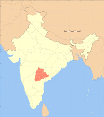
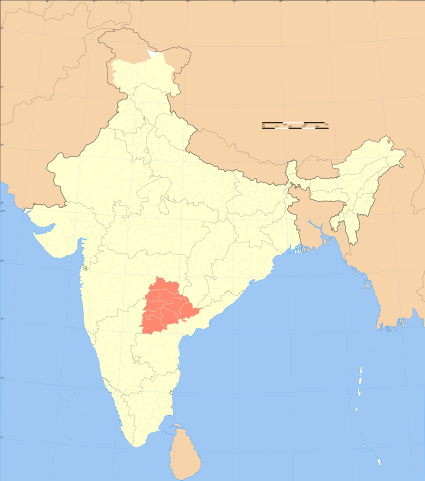
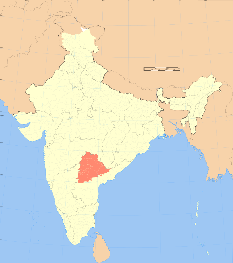
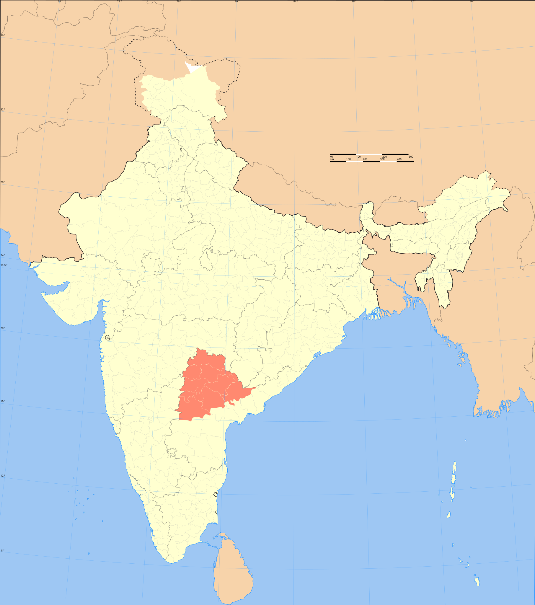
Telangana locator map
DescriptionIndia Telangana locator map.svg
Locator map of the region of Telangana, India with district boundaries.
Map legend
Tarix
Mənbə
Öz işi International Borders: University of Texas map library - India Political map 2001 Disputed Borders: University of Texas map library - China-India Borders - Eastern Sector 1988 & Western Sector 1988 - Kashmir Region 2004 - Kashmir Maps. State and District boundaries: Census of India - 2001 Census State Maps - Survey of India Maps.
Other sources: US Army Map Service, Survey of India Map Explorer, Columbia University
If you are using the image under the creative commons share alike license please credit the photo CC-by-sa PlaneMad/Wikimedia and include a link to this page. No explicit permission is needed from me, but id appreciate an email if my work has been of help to you.
If you dont want to release your work under a creative commons license, please mail me at arun.planemad@gmail.com or catch me at my Website to negotiate a custom license as per your needs.
İcazə (Faylın təkrar istifadəsi)
I, the copyright holder of this work, hereby publish it under the following license:
Bu fayl Creative Commons Attribution-Share Alike 3.0 Sinqapur lisenziyası altında yayımlanır.
Azadsınız:
paylaşmaq – əsəri köçürmək, paylamaq və ötürmək üçün
remiks etmək – əsəri adaptasiya etmək
Aşağıdakı şərtlərə riayət etməklə:
istinad – Müvafiq kredit verməlisiniz, lisenziyaya bir keçid verməlisiniz və dəyişikliklərin olub olmadığını bildirməlisiniz. Bunu hər hansı bir ağlabatan şəkildə edə bilərsiniz, ancaq lisenziyalaşdırıcının sizi və ya istifadənizi təsdiqləməsini təklif edən bir şəkildə deyil.
bənzər paylaşma – Əsəri remix edirsinizsə, dəyişdirirsinizsə və ya üzərində iş aparırsınızsa, öz töhfələrinizi orijinalda olduğu kimi eyni və ya uyğun lisenziya altında yayımlamalısınız.
The frontiers depicted on the Indian maps in Wikipedia are from a neutral point of view and may differ from official government maps of India, Pakistan and China. Please consult local laws governing publication of maps before usage.
Georeference the map in Wikimaps Warper If inappropriate please set warp_status = skip to hide.
Archival data
Qeydlər
Part of WikiProject India Maps
SVG genesis
InfoField
The source code of this SVG is invalid due to an error.
This W3C-invalid map was created with Adobe Illustrator.
This map uses embedded text that can be easily translated using a text editor.
This SVG map contains embedded raster graphics.[1] Such images are liable to produce inferior results when scaled to different sizes (as well as possibly being very inefficient in file size). If appropriate to do so, they should be replaced with images created using vector graphics. Note: This template is only supposed to be used if the SVG file mixes vector and raster graphics. If the SVG file only contains raster graphics {{FakeSVG}} is supposed to be used. See also {{TopoSVG}}.
The territorial boundaries of India are shown as per the actual ground situation in accordance with international practices followed by the United Nations ([2], ) and the National Geographic Society (, [5])
This map is meant to be for illustrative purpose only and is not authenticated by official government sources. Please check the list of sources and references used to create the map for a measure of accuracy and verifiability.
The usage of these maps in India, Pakistan and China are governed by different laws that restrict depictions of boundaries other than what is officially recognized by the state. Please check local laws and modify the map accordingly before use.
Explanation of disputed boundaries
Boundary of Indian claim : The territory India claims is legally theirs, but the claim is disputed by China and Pakistan.
Line of Control/Line of Conflict : The de facto administrative boundary recognised by the international community. This UN ceasefire line is considered as a temporary solution to an ongoing conflict since the departure of the British Raj.
Borders of disputed regions
The depicted extent of the former territory of the British Indian Empire, succeeded by Republic of India, may not be accepted by few countries as legal due to ongoing border disputes:
The northern Himalayan region of the disputed territory Indian-administered Kashmir is claimed by India including (Pakistan-administered Kashmir) and the Chinese-occupied territory of (Ladakh plateau). Since 1972, it is divided between all three countries. See also Line of Control and Line of Actual Control.
Siachen glacier (shown white) is an actively contested region between India and Pakistan. Since 1984, the region is under Indian control.
The northeastern territory of Arunachal Pradesh is almost entirely claimed by China as part of its Tibetan territory.
Minor areas of eastern Kashmir's Ladakh division, Himachal Pradesh and Uttarakhand on the Chinese frontier are claimed by China. These areas are under Indian control.
A small area of Uttarakhand adjoining the Nepal border along the Sarda river is disputed between the two countries.
For a detailed map of all disputed regions in South Asia, see Image:India disputed areas map.svg
Internal borders
The borders of the state of Meghalaya, Assam and Arunachal Pradesh are shown as interpreted from the North-Eastern Areas (Reorganisation) Act, 1971, but has yet to be verified.
Territorial waters
The limit of the territorial waters of India extends to twelve nautical miles measured from the appropriate baseline. See this for more information.
Captions
Add a one-line explanation of what this file represents
Items portrayed in this file
təsvir edir
copyright status ingilis
copyrighted ingilis
lisenziya
Creative Commons Attribution-ShareAlike 3.0 Unported ingilis
MIME type ingilis
image/svg+xml
Faylın tarixçəsi
Faylın əvvəlki versiyasını görmək üçün gün/tarix bölməsindəki tarixlərə klikləyin.
{{WikiProject_India_Maps |Title=Telangana locator map |Description=Locator map of the region of Telangana, India with district boundaries. |Source=. |Date=September 2006 |Author={{User:PlaneMad/Info}} }}
{{WikiProject_India_Maps |Title=Telangana locator map |Description=Locator map of the region of Telangana, India with district boundaries. |Source=. |Date=September 2006 |Author=w:user:Planemad |Thumbdir=CHANGE }}
fayl, india, telangana, locator, fayl, faylın, tarixçəsi, fayl, keçidləri, faylın, qlobal, istifadəsibu, faylın, formatındakı, görünüşünün, ölçüsü, piksel, digər, ölçülər, piksel, piksel, piksel, piksel, piksel, piksel, faylın, orijinalı, 8206, faylı, nominal,. Fayl Faylin tarixcesi Fayl kecidleri Faylin qlobal istifadesiBu SVG faylin PNG formatindaki bu gorunusunun olcusu 530 599 piksel Diger olculer 212 240 piksel 425 480 piksel 680 768 piksel 906 1 024 piksel 1 812 2 048 piksel 1 639 1 852 piksel Faylin orijinali 8206 SVG fayli nominal olaraq 1 639 1 852 piksel faylin olcusu 795 KB Bu fayl Vikimedia Commons dadirve diger layihelerde istifade edile biler Faylin tesvir sehifesine get Basliq Telangana locator map DescriptionIndia Telangana locator map svg Locator map of the region of Telangana India with district boundaries Map legend Tarix sentyabr 2006 Menbe Oz isi International Borders University of Texas map library India Political map 2001 Disputed Borders University of Texas map library China India Borders Eastern Sector 1988 amp Western Sector 1988 Kashmir Region 2004 Kashmir Maps State and District boundaries Census of India 2001 Census State Maps Survey of India Maps Other sources US Army Map Service Survey of India Map Explorer Columbia University Yaradici This Image was created byUser PlaneMad If you are using the image under the creative commons share alike license please credit the photo CC by sa PlaneMad Wikimedia and include a link to this page No explicit permission is needed from me but id appreciate an email if my work has been of help to you If you dont want to release your work under a creative commons license please mail me at arun planemad gmail com or catch me at my Website to negotiate a custom license as per your needs Icaze Faylin tekrar istifadesi I the copyright holder of this work hereby publish it under the following license Bu fayl Creative Commons Attribution Share Alike 3 0 Sinqapur lisenziyasi altinda yayimlanir Azadsiniz paylasmaq eseri kocurmek paylamaq ve oturmek ucun remiks etmek eseri adaptasiya etmek Asagidaki sertlere riayet etmekle istinad Muvafiq kredit vermelisiniz lisenziyaya bir kecid vermelisiniz ve deyisikliklerin olub olmadigini bildirmelisiniz Bunu her hansi bir aglabatan sekilde ede bilersiniz ancaq lisenziyalasdiricinin sizi ve ya istifadenizi tesdiqlemesini teklif eden bir sekilde deyil benzer paylasma Eseri remix edirsinizse deyisdirirsinizse ve ya uzerinde is aparirsinizsa oz tohfelerinizi orijinalda oldugu kimi eyni ve ya uygun lisenziya altinda yayimlamalisiniz https creativecommons org licenses by sa 3 0 CC BY SA 3 0 Creative Commons Attribution Share Alike 3 0 true true The frontiers depicted on the Indian maps in Wikipedia are from a neutral point of view and may differ from official government maps of India Pakistan and China Please consult local laws governing publication of maps before usage nbsp Geotemporal data Date depicted second half of 20 century ve 21 century Spatial reference system conic Bounding box 38 04 N 64 13 E 38 06 N 64 21 E 38 06 64 21 38 34 N 100 03 E 38 57 N 100 05 E 38 57 100 05 5 07 N 68 26 E 5 12 N 68 44 E 5 12 68 44 5 36 N 96 52 E 5 60 N 96 87 E 5 60 96 87 Georeferencing Georeference the map in Wikimaps Warper If inappropriate please set warp status skip to hide nbsp Archival data Qeydler Part of WikiProject India Maps SVG nbsp genesisInfoField nbsp The source code of this SVG is invalid due to an error nbsp This W3C invalid map was created with Adobe Illustrator nbsp This map uses embedded text nbsp that can be easily translated using a text editor This SVG map contains embedded raster graphics 1 Such images are liable to produce inferior results when scaled to different sizes as well as possibly being very inefficient in file size If appropriate to do so they should be replaced with images created using vector graphics Note This template is only supposed to be used if the SVG file mixes vector and raster graphics If the SVG file only contains raster graphics FakeSVG is supposed to be used See also TopoSVG Mundericat 1 Notes 1 1 Depiction of India s borders 1 2 Explanation of disputed boundaries 1 3 Borders of disputed regions 1 4 Internal borders 1 5 Territorial waters Notes Depiction of India s borders The territorial boundaries of India are shown as per the actual ground situation in accordance with international practices followed by the United Nations 2 3 and the National Geographic Society 4 5 This map is meant to be for illustrative purpose only and is not authenticated by official government sources Please check the list of sources and references used to create the map for a measure of accuracy and verifiability The usage of these maps in India Pakistan and China are governed by different laws that restrict depictions of boundaries other than what is officially recognized by the state Please check local laws and modify the map accordingly before use Explanation of disputed boundaries Boundary of Indian claim nbsp The territory India claims is legally theirs but the claim is disputed by China and Pakistan Line of Control Line of Conflict nbsp The de facto administrative boundary recognised by the international community This UN ceasefire line is considered as a temporary solution to an ongoing conflict since the departure of the British Raj Borders of disputed regions The depicted extent of the former territory of the British Indian Empire succeeded by Republic of India may not be accepted by few countries as legal due to ongoing border disputes The northern Himalayan region of the disputed territory Indian administered Kashmir is claimed by India including Pakistan administered Kashmir and the Chinese occupied territory of Ladakh plateau Since 1972 it is divided between all three countries See also Line of Control and Line of Actual Control Siachen glacier shown white is an actively contested region between India and Pakistan Since 1984 the region is under Indian control The northeastern territory of Arunachal Pradesh is almost entirely claimed by China as part of its Tibetan territory Minor areas of eastern Kashmir s Ladakh division Himachal Pradesh and Uttarakhand on the Chinese frontier are claimed by China These areas are under Indian control A small area of Uttarakhand adjoining the Nepal border along the Sarda river is disputed between the two countries For a detailed map of all disputed regions in South Asia see Image India disputed areas map svg Internal borders The borders of the state of Meghalaya Assam and Arunachal Pradesh are shown as interpreted from the North Eastern Areas Reorganisation Act 1971 but has yet to be verified Territorial waters The limit of the territorial waters of India extends to twelve nautical miles measured from the appropriate baseline See this for more information CaptionsazerbaycancaAdd a one line explanation of what this file representsItems portrayed in this filetesvir edircopyright status nbsp ingiliscopyrighted nbsp ingilislisenziyaCreative Commons Attribution ShareAlike 3 0 Unported nbsp ingilisMIME type nbsp ingilisimage svg xml Faylin tarixcesi Faylin evvelki versiyasini gormek ucun gun tarix bolmesindeki tarixlere klikleyin Tarix VaxtKicik sekilOlculerIstifadeciSerh indiki19 14 20 may 20081 639 1 852 795 KB Planemad WikiProject India Maps Title Telangana locator map Description Locator map of the region of Telangana India with district boundaries Source Date September 2006 Author User PlaneMad Info 17 52 4 sentyabr 20061 639 1 852 795 KB Planemad WikiProject India Maps Title Telangana locator map Description Locator map of the region of Telangana India with district boundaries Source Date September 2006 Author w user Planemad Thumbdir CHANGE Fayl kecidleri Bu sekile olan kecidler Telanqana Faylin qlobal istifadesi Bu fayl asagidaki vikilerde istifade olunur as wikipedia org layihesinde istifadesi ত লঙ গ ন হ ইদৰ ব দ ba wikipedia org layihesinde istifadesi Һindostan be wikipedia org layihesinde istifadesi Shtaty i terytoryi Indyi bg wikipedia org layihesinde istifadesi Telangana bn wikipedia org layihesinde istifadesi ত ল ঙ গ ন br wikipedia org layihesinde istifadesi Telangana ca wikipedia org layihesinde istifadesi Telangana cdo wikipedia org layihesinde istifadesi Telangana ceb wikipedia org layihesinde istifadesi Telangana da wikipedia org layihesinde istifadesi Telangana de wikipedia org layihesinde istifadesi Vorlage Diskussion Hauptseite Aktuelles Archiv 2014 Juni dty wikipedia org layihesinde istifadesi त लङ ग न en wikipedia org layihesinde istifadesi List of Telugu language television channels Wikipedia WikiProject Indian maps Wikipedia WikiProject India History of Andhra Pradesh Telangana movement User Hariehkr 1969 Telangana Agitation Template User Telangana movement Wikipedia Top 25 Report July 28 to August 3 2013 User Anirudh palakurthi User Pranayraj1985 Wikipedia talk Noticeboard for India related topics Archive 57 User Rizwanmahai Template User WP Telangana doc Template User Telangana doc1 Template User in Telangana Template User in Telangana doc Category Wikipedians in Telangana Template User interest Telangana Template User interest Telangana doc Wikipedia WikiProject Telangana Template User citizen Telangana Template User citizen Telangana doc Template User from Telangana Template User from Telangana doc User JohnnyBlaze007 Wikipedia Userboxes Life Ethnicity 02 User Haseeb1608 User WeAreCreative User Smadhavichandra Category Wikipedians interested in Telangana User Sagavaj User Derivator2017 Wikipedia WikiProject India Templates Wikipedia WikiProject India userbox templates Template User WP Telangana Category WikiProject Telangana members Bu faylin qlobal istifadesine baxin Menbe https az wikipedia org wiki Fayl India Telangana locator map svg, wikipedia, oxu, kitab, kitabxana, axtar, tap, hersey,
ne axtarsan burda
, en yaxsi meqale sayti, meqaleler, kitablar, oyrenmek, wiki, bilgi, tarix, seks, porno, indir, yukle, sex, azeri sex, azeri, seks yukle, sex yukle, izle, seks izle, porno izle, mobil seks, telefon ucun, chat, azeri chat, tanisliq, tanishliq, azeri tanishliq, sayt, medeni, medeni saytlar, chatlar, mekan, tanisliq mekani, mekanlari, yüklə, pulsuz, pulsuz yüklə, mp3, video, mp4, 3gp, jpg, jpeg, gif, png, şəkil, muisiqi, mahnı, kino, film, kitab, oyun, oyunlar.