Bu fayl "Vikimedia Commons"dadır və digər layihələrdə istifadə edilə bilər.
Faylın təsvir səhifəsinə get
Xülasə
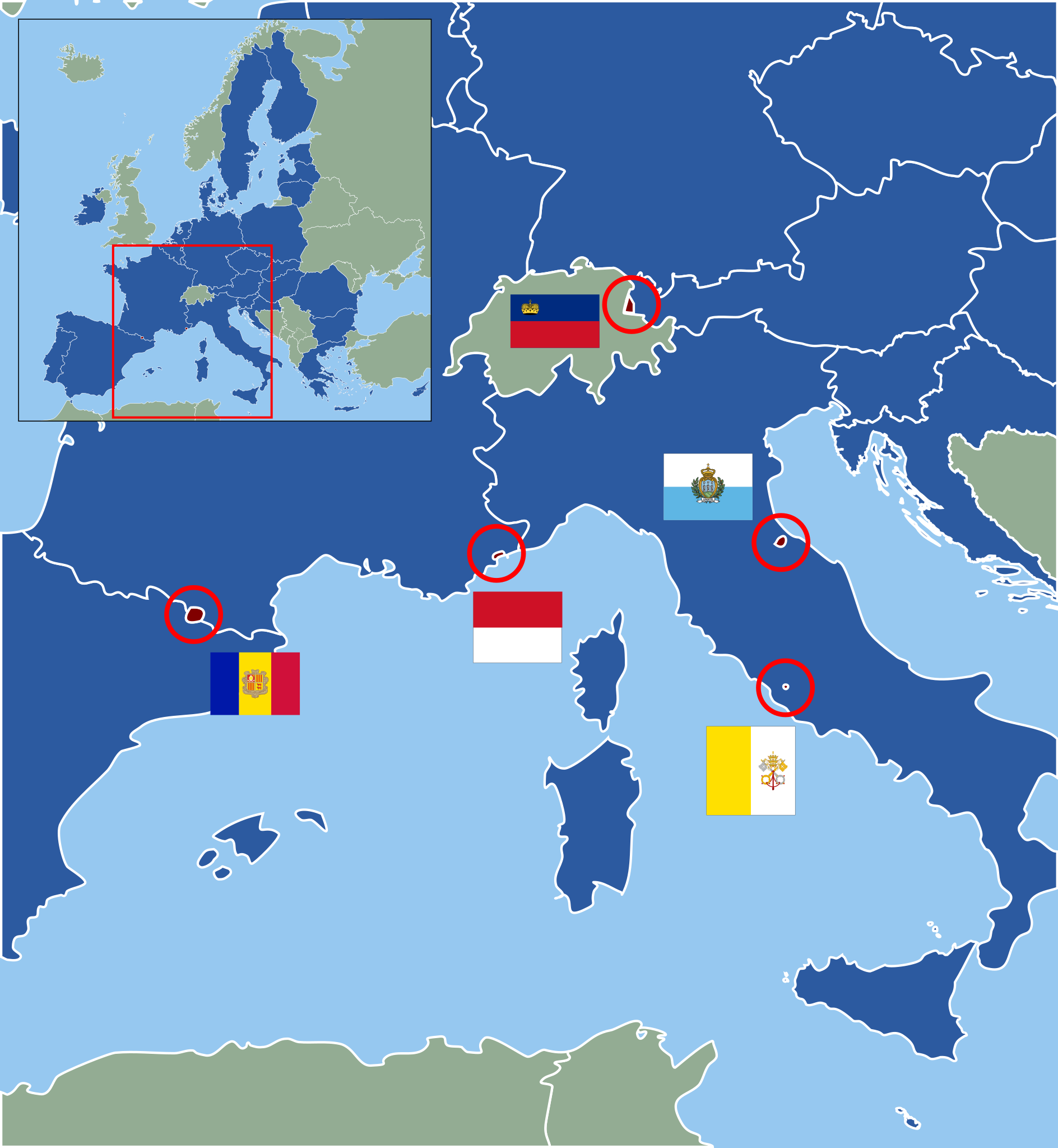
İzahEuropean microstates map.svg
Deutsch: Karte der europäischen Zwergstaaten und der Europäischen Union (2013). Staaten der EU sind blau, Zuordnung der Mikrostaaten nach ihren Flaggen wie folgt:
English: Map of European Microstates and the European Union in 2013. The European Union is in blue, microstate flags as follows:
Andorra Liechtenstein Monaco San Marino
Vatican City
Tarix
(UTC)
Mənbə
Blank_map_of_Europe.svg
European_Microstates_Map.png
Müəllif
Blank_map_of_Europe.svg: maix¿?
European_Microstates_Map.png: JLogan
derivative work: Master Uegly (talk)
Bu təsvirin redaktəsi, orijinala əsaslanaraq rəqəmsal qaydadadır. Dəyişiklik: Vectorization under usage of blank svg map. İlkin təsvir buradadır: European Microstates Map.png. Redaktə etdi Master Uegly.
Lisenziya
Bu fayl Creative Commons Attribution-Share Alike 3.0 Sinqapur lisenziyası altında yayımlanır.
Azadsınız:
paylaşmaq – əsəri köçürmək, paylamaq və ötürmək üçün
remiks etmək – əsəri adaptasiya etmək
Aşağıdakı şərtlərə riayət etməklə:
istinad – Müvafiq kredit verməlisiniz, lisenziyaya bir keçid verməlisiniz və dəyişikliklərin olub olmadığını bildirməlisiniz. Bunu hər hansı bir ağlabatan şəkildə edə bilərsiniz, ancaq lisenziyalaşdırıcının sizi və ya istifadənizi təsdiqləməsini təklif edən bir şəkildə deyil.
bənzər paylaşma – Əsəri remix edirsinizsə, dəyişdirirsinizsə və ya üzərində iş aparırsınızsa, öz töhfələrinizi orijinalda olduğu kimi eyni və ya uyğun lisenziya altında yayımlamalısınız.
https://creativecommons.org/licenses/by-sa/3.0 CC BY-SA 3.0 Creative Commons Attribution-Share Alike 3.0 truetrue
Orijinal yükləmə gündəliyi
This image is a derivative work of the following images:
File:Blank_map_of_Europe.svg licensed with Cc-by-sa-2.5
2011-08-23T10:26:48Z Heb 680x520 (604212 Bytes) Added [[:en:Bornholm]] (taken from [[:File:Denmark blank map.svg]])
2011-04-12T00:40:40Z Alphathon 680x520 (602549 Bytes) Upgraded Sicily based on "File:Freeworldmaps-sicily.jpg". Upgraded Malta based on "File:Map of Malta 2.png". Simplified Croatian borders.
2011-04-10T21:43:04Z Alphathon 680x520 (607359 Bytes) Upgraded Croatia, Bosnia & Herzegovina, Slovenia and surrounding countries based on data from "File:Kroatien - Politische Gliederung (Karte).png"
2011-04-10T20:05:09Z Alphathon 680x520 (568373 Bytes) Improved Serbia, Montenegro and surrounding countries using data from "File:Serbia Map.png". Fixed Serbia-Montenegro border. Added Kosovo (using dashed border, since it is not a universally recognised nation, and left the lan
2011-04-10T15:55:02Z Alphathon 680x520 (524980 Bytes) Tweaked Ukraine and surrounding countries based on data from "File:Up-map.png"
2011-04-10T04:02:09Z Alphathon 680x520 (511168 Bytes) Improved Greece, Albania, F.Y.R. Macedonia and Bulgaria based on "File:Greece topo.jpg"
2011-04-10T02:48:52Z Alphathon 680x520 (505569 Bytes) Tweaked Germany and surrounding countries based on info from "File:Germany_general_map.png"
2011-04-10T01:54:05Z Alphathon 680x520 (493733 Bytes) Converted all lakes back to separate layer. Added Finish lakes and tweaked Finland shape based on "File:Finland 1996 CIA map.jpg". Added Swiss lakes based on "File:Suisse cantons.svg". Tweaked Scotland and added Lochs.
2011-04-10T00:07:54Z Alphathon 680x520 (450120 Bytes) Improved England outline and added Isle of Wight based on "File:England Regions - Blank.svg". Improved Denmark based on "File:2 digit postcode danmark.png". Improved Sweden based on "File:Map of Sweden, CIA, 1996.jpg"
2011-04-08T15:53:07Z Alphathon 680x520 (438878 Bytes) Upgraded/fixed various parts of the map. Details: *Some minor fixes to Ireland and added some of the larger lakes based on [[:File:Ireland_trad_counties_named.svg]] *Pretty major fixes to Scotland (mainly the west coast and i
(10 more entrys follow)
File:European_Microstates_Map.png licensed with PD-self
2007-06-20T12:16:46Z JLogan 212x217 (8731 Bytes) {{Information |Description=Map of European Microstates |Source=self-made |Date=12 March 2007 |Author= [[User:JLogan|JLogan]] }}
Uploaded with derivativeFX
Captions
Add a one-line explanation of what this file represents
Items portrayed in this file
təsvir edir
copyright status ingilis
copyrighted ingilis
lisenziya
Creative Commons Attribution-ShareAlike 3.0 Unported ingilis
yaranma tarixi
9 dekabr 2011
Faylın tarixçəsi
Faylın əvvəlki versiyasını görmək üçün gün/tarix bölməsindəki tarixlərə klikləyin.
== {{int:filedesc}} == {{Information |Description={{de|Karte der europäischen Zwergstaaten und der Europäischen Union (2010). Staaten der EU sind blau, Zuordnung der Mikrostaaten nach ihren Flaggen wie folgt:}} {{en|Map of European Microstates and the E
Relations entre l'Union européenne et les micro-États européens
Micro-États européens
Mikropaństwo
Metaməlumatlar
Bu faylda fotoaparat və ya skanerlə əlavə olunmuş məlumatlar var. Əgər fayl sonradan redaktə olunubsa, bəzi parametrlər bu şəkildə göstərilənlərdən fərqli ola bilər.
Şəkil başlığı
A blank Map of Europe. Every country has an id which is its ISO-3166-1-ALPHA2 code in lower case.
Members of the EU have a class="eu", countries in europe (which I found turkey to be but russia not) have a class="europe". Certain countries are further subdivided the United Kingdom has gb-gbn for Great Britain and gb-nir for Northern Ireland. Russia is divided into ru-kgd for the Kaliningrad Oblast and ru-main for the Main body of Russia. There is the additional grouping #xb for the "British Islands" (the UK with its Crown Dependencies - Jersey, Guernsey and the Isle of Man) Contributors. Original Image: (http://commons.wikimedia.org/wiki/Image:Europe_countries.svg) Júlio Reis (http://commons.wikimedia.org/wiki/User:Tintazul). Recolouring and tagging with country codes: Marian "maix" Sigler (http://commons.wikimedia.org/wiki/User:Maix) Improved geographical features: http://commons.wikimedia.org/wiki/User:W!B: Updated to reflect dissolution of Serbia & Montenegro: http://commons.wikimedia.org/wiki/User:Zirland Updated to include British Crown Dependencies as seperate entities and regroup them as "British Islands", with some simplifications to the XML and CSS: James Hardy (http://commons.wikimedia.org/wiki/User:MrWeeble)
fayl, european, microstates, fayl, faylın, tarixçəsi, istifadə, edilən, səhifələr, faylın, qlobal, istifadəsi, metaməlumatlarbu, faylın, formatındakı, görünüşünün, ölçüsü, piksel, digər, ölçülər, piksel, piksel, piksel, piksel, piksel, faylın, orijinalı, 8206,. Fayl Faylin tarixcesi Istifade edilen sehifeler Faylin qlobal istifadesi MetamelumatlarBu SVG faylin PNG formatindaki bu gorunusunun olcusu 553 600 piksel Diger olculer 221 240 piksel 442 480 piksel 708 768 piksel 944 1 024 piksel 1 888 2 048 piksel Faylin orijinali 8206 SVG fayli nominal olaraq 553 600 piksel faylin olcusu 1 18 MB Bu fayl Vikimedia Commons dadirve diger layihelerde istifade edile biler Faylin tesvir sehifesine get Xulase IzahEuropean microstates map svg Deutsch Karte der europaischen Zwergstaaten und der Europaischen Union 2013 Staaten der EU sind blau Zuordnung der Mikrostaaten nach ihren Flaggen wie folgt English Map of European Microstates and the European Union in 2013 The European Union is in blue microstate flags as follows Andorra Liechtenstein Monaco San Marino Vatican CityTarix 9 dekabr 2011 23 40 UTC Menbe Blank map of Europe svg European Microstates Map pngMuellif Blank map of Europe svg maix European Microstates Map png JLogan derivative work Master Uegly talk Bu tesvirin redaktesi orijinala esaslanaraq reqemsal qaydadadir Deyisiklik Vectorization under usage of blank svg map Ilkin tesvir buradadir European Microstates Map png Redakte etdi Master Uegly Lisenziya Bu fayl Creative Commons Attribution Share Alike 3 0 Sinqapur lisenziyasi altinda yayimlanir Azadsiniz paylasmaq eseri kocurmek paylamaq ve oturmek ucun remiks etmek eseri adaptasiya etmek Asagidaki sertlere riayet etmekle istinad Muvafiq kredit vermelisiniz lisenziyaya bir kecid vermelisiniz ve deyisikliklerin olub olmadigini bildirmelisiniz Bunu her hansi bir aglabatan sekilde ede bilersiniz ancaq lisenziyalasdiricinin sizi ve ya istifadenizi tesdiqlemesini teklif eden bir sekilde deyil benzer paylasma Eseri remix edirsinizse deyisdirirsinizse ve ya uzerinde is aparirsinizsa oz tohfelerinizi orijinalda oldugu kimi eyni ve ya uygun lisenziya altinda yayimlamalisiniz https creativecommons org licenses by sa 3 0 CC BY SA 3 0 Creative Commons Attribution Share Alike 3 0 true trueOrijinal yukleme gundeliyi This image is a derivative work of the following images File Blank map of Europe svg licensed with Cc by sa 2 5 2011 09 19T22 57 58Z Alphathon 680x520 603759 Bytes Added North Northern Cyprus 2011 08 23T10 26 48Z Heb 680x520 604212 Bytes Added en Bornholm taken from File Denmark blank map svg 2011 04 12T00 40 40Z Alphathon 680x520 602549 Bytes Upgraded Sicily based on File Freeworldmaps sicily jpg Upgraded Malta based on File Map of Malta 2 png Simplified Croatian borders 2011 04 10T21 43 04Z Alphathon 680x520 607359 Bytes Upgraded Croatia Bosnia amp Herzegovina Slovenia and surrounding countries based on data from File Kroatien Politische Gliederung Karte png 2011 04 10T20 05 09Z Alphathon 680x520 568373 Bytes Improved Serbia Montenegro and surrounding countries using data from File Serbia Map png Fixed Serbia Montenegro border Added Kosovo using dashed border since it is not a universally recognised nation and left the lan 2011 04 10T15 55 02Z Alphathon 680x520 524980 Bytes Tweaked Ukraine and surrounding countries based on data from File Up map png 2011 04 10T04 02 09Z Alphathon 680x520 511168 Bytes Improved Greece Albania F Y R Macedonia and Bulgaria based on File Greece topo jpg 2011 04 10T02 48 52Z Alphathon 680x520 505569 Bytes Tweaked Germany and surrounding countries based on info from File Germany general map png 2011 04 10T01 54 05Z Alphathon 680x520 493733 Bytes Converted all lakes back to separate layer Added Finish lakes and tweaked Finland shape based on File Finland 1996 CIA map jpg Added Swiss lakes based on File Suisse cantons svg Tweaked Scotland and added Lochs 2011 04 10T00 07 54Z Alphathon 680x520 450120 Bytes Improved England outline and added Isle of Wight based on File England Regions Blank svg Improved Denmark based on File 2 digit postcode danmark png Improved Sweden based on File Map of Sweden CIA 1996 jpg 2011 04 08T15 53 07Z Alphathon 680x520 438878 Bytes Upgraded fixed various parts of the map Details Some minor fixes to Ireland and added some of the larger lakes based on File Ireland trad counties named svg Pretty major fixes to Scotland mainly the west coast and i 10 more entrys follow File European Microstates Map png licensed with PD self 2007 06 20T12 16 46Z JLogan 212x217 8731 Bytes Information Description Map of European Microstates Source self made Date 12 March 2007 Author User JLogan JLogan Uploaded with derivativeFXCaptionsazerbaycancaAdd a one line explanation of what this file representsItems portrayed in this filetesvir edircopyright status ingiliscopyrighted ingilislisenziyaCreative Commons Attribution ShareAlike 3 0 Unported ingilisyaranma tarixi9 dekabr 2011 Faylin tarixcesi Faylin evvelki versiyasini gormek ucun gun tarix bolmesindeki tarixlere klikleyin Tarix VaxtKicik sekilOlculerIstifadeciSerh indiki13 04 27 fevral 2022553 600 1 18 MB Welkendown mistake corrected Iceland 12 58 27 fevral 2022553 600 1 17 MB Welkendown mistake corrected red circle around Monaco 12 56 27 fevral 2022553 600 1 17 MB Welkendlittle cosmetic corrections of the borders of the map and the shape of Monaco 11 41 2 fevral 2020553 600 1 17 MB NordNordWestupd 11 40 30 iyun 2013553 600 1 17 MB NordNordWestupd 23 59 9 dekabr 2011553 600 1 17 MB Master Uegly int filedesc Information Description de Karte der europaischen Zwergstaaten und der Europaischen Union 2010 Staaten der EU sind blau Zuordnung der Mikrostaaten nach ihren Flaggen wie folgt en Map of European Microstates and the E Istifade edilen sehifeler Bu sekile olan kecidler Cirtdan dovletler Faylin qlobal istifadesi Bu fayl asagidaki vikilerde istifade olunur cs wikipedia org layihesinde istifadesi Evropske ministaty a Evropska unie de wikipedia org layihesinde istifadesi Europaische Union Zwergstaat Mitgliedstaaten der Europaischen Union Beitrittskandidaten der Europaischen Union Benutzer Oesterreicher12 Spielwiese 2 es wikipedia org layihesinde istifadesi Relaciones Union Europea microestados europeos Ampliacion potencial de la Union Europea fa wikipedia org layihesinde istifadesi کشورک fi wikipedia org layihesinde istifadesi Wikipedia Viikon kilpailu Viikon kilpailu 2016 14 fr wikipedia org layihesinde istifadesi Utilisateur Gilles Mairet Micro etats europeens et Union europeenne Relations entre l Union europeenne et les micro Etats europeens Micro Etats europeens hr wikipedia org layihesinde istifadesi Prosirenje Europske unije hy wikipedia org layihesinde istifadesi Եվրոպական միության հետագա ընդլայնում lb wikipedia org layihesinde istifadesi Zwergstaat pl wikipedia org layihesinde istifadesi Panstwa kandydujace do Unii Europejskiej Mikropanstwo pt wikipedia org layihesinde istifadesi Microestado ru wikipedia org layihesinde istifadesi Dalnejshee rasshirenie Evropejskogo soyuza sv wikipedia org layihesinde istifadesi Europeiska unionens utbredning och utvidgning th wikipedia org layihesinde istifadesi culrth uk wikipedia org layihesinde istifadesi Mikroderzhavi ta Yevropejskij Soyuz www wikidata org layihesinde istifadesi Q2589382 zh wikipedia org layihesinde istifadesi 欧洲联盟扩大Metamelumatlar Bu faylda fotoaparat ve ya skanerle elave olunmus melumatlar var Eger fayl sonradan redakte olunubsa bezi parametrler bu sekilde gosterilenlerden ferqli ola biler Sekil basligiA blank Map of Europe Every country has an id which is its ISO 3166 1 ALPHA2 code in lower case Members of the EU have a class eu countries in europe which I found turkey to be but russia not have a class europe Certain countries are further subdivided the United Kingdom has gb gbn for Great Britain and gb nir for Northern Ireland Russia is divided into ru kgd for the Kaliningrad Oblast and ru main for the Main body of Russia There is the additional grouping xb for the British Islands the UK with its Crown Dependencies Jersey Guernsey and the Isle of Man Contributors Original Image http commons wikimedia org wiki Image Europe countries svg Julio Reis http commons wikimedia org wiki User Tintazul Recolouring and tagging with country codes Marian maix Sigler http commons wikimedia org wiki User Maix Improved geographical features http commons wikimedia org wiki User W B Updated to reflect dissolution of Serbia amp Montenegro http commons wikimedia org wiki User Zirland Updated to include British Crown Dependencies as seperate entities and regroup them as British Islands with some simplifications to the XML and CSS James Hardy http commons wikimedia org wiki User MrWeeble Released under CreativeCommons Attribution ShareAlike http creativecommons org licenses by sa 2 5 Genislik553Hundurluk600 Menbe https az wikipedia org wiki Fayl European microstates map svg, wikipedia, oxu, kitab, kitabxana, axtar, tap, hersey,
ne axtarsan burda
, en yaxsi meqale sayti, meqaleler, kitablar, oyrenmek, wiki, bilgi, tarix, seks, porno, indir, yukle, sex, azeri sex, azeri, seks yukle, sex yukle, izle, seks izle, porno izle, mobil seks, telefon ucun, chat, azeri chat, tanisliq, tanishliq, azeri tanishliq, sayt, medeni, medeni saytlar, chatlar, mekan, tanisliq mekani, mekanlari, yüklə, pulsuz, pulsuz yüklə, mp3, video, mp4, 3gp, jpg, jpeg, gif, png, şəkil, muisiqi, mahnı, kino, film, kitab, oyun, oyunlar.