Bu fayl "Vikimedia Commons"dadır və digər layihələrdə istifadə edilə bilər.
Faylın təsvir səhifəsinə get
Xülasə
İzahZalzala Jazeera 2013 Gwadar.jpg
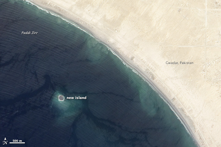
English: Zalzala Jazeera (Earthquake Island) appears near the center of this image of the bay west of Gwadar, Pakistan.
On September 26, 2013, the Advanced Land Imager (ALI) on NASA’s Earth Observing-1 (EO-1) satellite captured the top image of that new island, which sits roughly one kilometer (0.6 miles) offshore. Likely a “mud volcano,” the island rose from the seafloor near Gwadar on September 24, shortly after the earthquake struck about 380 kilometers (230 miles) inland. File:Gwadar satellite view.jpg, acquired by the Operational Land Imager on the Landsat 8 satellite, shows the same area on April 17, 2013.
In the satellite images, lighter shades of green and tan in the water reveal shallow seafloor or suspended sediment. The water depth around the new island is roughly 15 to 20 meters, according to marine geologist Asif Inam of Pakistan’s National Institute of Oceanography. “The floor in that area is generally flat, but the gradient in this area changes quite abruptly,” Inam said. The top image from ALI is also clear enough to show the parallel ripples of waves marching toward the shore.
Bu faylda fotoaparat və ya skanerlə əlavə olunmuş məlumatlar var. Əgər fayl sonradan redaktə olunubsa, bəzi parametrlər bu şəkildə göstərilənlərdən fərqli ola bilər.
Unique ID of original document
xmp.did:92DB18B2782068118C14B8A75F09C7C4
Proqram təminatı
IDL 8.2.3, Exelis Visual Information Solutions, Inc.
IIM versiya
2
Fevral 06, 2023
fayl, zalzala, jazeera, 2013, gwadar, fayl, faylın, tarixçəsi, istifadə, edilən, səhifələr, faylın, qlobal, istifadəsi, metaməlumatlardaha, yüksək, versiyası, yoxdur, zalzala, jazeera, 2013, gwadar, 8206, piksel, fayl, həcmi, mime, növü, image, jpeg, fayl, vik. Fayl Faylin tarixcesi Istifade edilen sehifeler Faylin qlobal istifadesi MetamelumatlarDaha yuksek versiyasi yoxdur Zalzala Jazeera 2013 Gwadar jpg 8206 720 480 piksel fayl hecmi 94 KB MIME novu image jpeg Bu fayl Vikimedia Commons dadirve diger layihelerde istifade edile biler Faylin tesvir sehifesine get Xulase IzahZalzala Jazeera 2013 Gwadar jpg English Zalzala Jazeera Earthquake Island appears near the center of this image of the bay west of Gwadar Pakistan On September 26 2013 the Advanced Land Imager ALI on NASA s Earth Observing 1 EO 1 satellite captured the top image of that new island which sits roughly one kilometer 0 6 miles offshore Likely a mud volcano the island rose from the seafloor near Gwadar on September 24 shortly after the earthquake struck about 380 kilometers 230 miles inland File Gwadar satellite view jpg acquired by the Operational Land Imager on the Landsat 8 satellite shows the same area on April 17 2013 In the satellite images lighter shades of green and tan in the water reveal shallow seafloor or suspended sediment The water depth around the new island is roughly 15 to 20 meters according to marine geologist Asif Inam of Pakistan s National Institute of Oceanography The floor in that area is generally flat but the gradient in this area changes quite abruptly Inam said The top image from ALI is also clear enough to show the parallel ripples of waves marching toward the shore Tarix 27 sentyabr 2013 21 12 46Menbe http earthobservatory nasa gov NaturalHazards view php id 82146Muellif NASADiger versiyalar Camera location25 10 46 56 N 62 13 50 52 E View this and other nearby images on OpenStreetMap25 179600 62 230700Lisenziya Public domain Public domain false falseThis file is in the public domain in the United States because it was solely created by NASA NASA copyright policy states that NASA material is not protected by copyright unless noted See Template PD USGov NASA copyright policy page or JPL Image Use Policy Warnings Use of NASA logos insignia and emblems is restricted per U S law 14 CFR 1221 The NASA website hosts a large number of images from the Soviet Russian space agency and other non American space agencies These are not necessarily in the public domain Materials based on Hubble Space Telescope data may be copyrighted if they are not explicitly produced by the STScI 1 See also PD Hubble and Cc Hubble The SOHO ESA amp NASA joint project implies that all materials created by its probe are copyrighted and require permission for commercial non educational use 2 Images featured on the Astronomy Picture of the Day APOD web site may be copyrighted 3 The National Space Science Data Center NSSDC site has been known to host copyrighted content Its photo gallery FAQ states that all of the images in the photo gallery are in the public domain Unless otherwise noted CaptionsazerbaycancaAdd a one line explanation of what this file representsItems portrayed in this filetesvir ediryaranma tarixi27 sentyabr 2013coordinates of the point of view ingilis25 10 46 6 N 62 13 50 5 E Faylin tarixcesi Faylin evvelki versiyasini gormek ucun gun tarix bolmesindeki tarixlere klikleyin Tarix VaxtKicik sekilOlculerIstifadeciSerh indiki01 33 28 sentyabr 2013720 480 94 KB Rehmanofficial nasa crop 01 18 28 sentyabr 2013459 486 30 KB Ke4rohUser created page with UploadWizard Istifade edilen sehifeler Bu sekile olan kecidler Zelzele adasi Faylin qlobal istifadesi Bu fayl asagidaki vikilerde istifade olunur ar wikipedia org layihesinde istifadesi جزيرة زلزلة as wikipedia org layihesinde istifadesi যলযল জ য ৰ bn wikipedia org layihesinde istifadesi জলজল জ জ র ca wikipedia org layihesinde istifadesi Illa Zalzala cs wikipedia org layihesinde istifadesi Wikipedista Dirillo Piskoviste el wikipedia org layihesinde istifadesi Zalzala Tzazira en wikipedia org layihesinde istifadesi Zalzala Koh es wikipedia org layihesinde istifadesi Isla Zalzala fa wikipedia org layihesinde istifadesi زلزله کوه fi wikipedia org layihesinde istifadesi Pakistanin maanjaristys 2013 fr wikipedia org layihesinde istifadesi Liste des iles nouvelles Zalzala Koh Liste des iles englouties id wikipedia org layihesinde istifadesi Zalzala Jazeera incubator wikimedia org layihesinde istifadesi Wp khw زلزلہ جزیرہ Wp bgn زلزله کوه it wikipedia org layihesinde istifadesi Isola Terremoto ja wikipedia org layihesinde istifadesi 地震島 新しい島 nl wikipedia org layihesinde istifadesi Zalzala Jazeera ru wikipedia org layihesinde istifadesi Zalzala scn wikipedia org layihesinde istifadesi Sittemmiru 2013 sd wikipedia org layihesinde istifadesi زلزلو ٻيٽ simple wikipedia org layihesinde istifadesi Zalzala Koh sr wikipedia org layihesinde istifadesi Zalzala ostrvo tr wikipedia org layihesinde istifadesi Zelzele Adasi Vikipedi Gunun maddeleri Mart 2017 Sablon GM 2017 03 20 Vikipedi Gunun maddeleri Temmuz 2020 Sablon GM 2020 07 22 uk wikipedia org layihesinde istifadesi Koristuvach Stefanko1982 Geografiya Zalzala ur wikipedia org layihesinde istifadesi زلزلہ جزیرہ vi wikipedia org layihesinde istifadesi Zalzala Jazeera www wikidata org layihesinde istifadesi Q14945772Metamelumatlar Bu faylda fotoaparat ve ya skanerle elave olunmus melumatlar var Eger fayl sonradan redakte olunubsa bezi parametrler bu sekilde gosterilenlerden ferqli ola biler Unique ID of original documentxmp did 92DB18B2782068118C14B8A75F09C7C4Proqram teminatiIDL 8 2 3 Exelis Visual Information Solutions Inc IIM versiya2 Menbe https az wikipedia org wiki Fayl Zalzala Jazeera 2013 Gwadar jpg, wikipedia, oxu, kitab, kitabxana, axtar, tap, hersey,
ne axtarsan burda
, en yaxsi meqale sayti, meqaleler, kitablar, oyrenmek, wiki, bilgi, tarix, seks, porno, indir, yukle, sex, azeri sex, azeri, seks yukle, sex yukle, izle, seks izle, porno izle, mobil seks, telefon ucun, chat, azeri chat, tanisliq, tanishliq, azeri tanishliq, sayt, medeni, medeni saytlar, chatlar, mekan, tanisliq mekani, mekanlari, yüklə, pulsuz, pulsuz yüklə, mp3, video, mp4, 3gp, jpg, jpeg, gif, png, şəkil, muisiqi, mahnı, kino, film, kitab, oyun, oyunlar.