Bu fayl "Vikimedia Commons"dadır və digər layihələrdə istifadə edilə bilər.
Faylın təsvir səhifəsinə get
Xülasə
İzahYenisei Ob Kara Sea.jpg
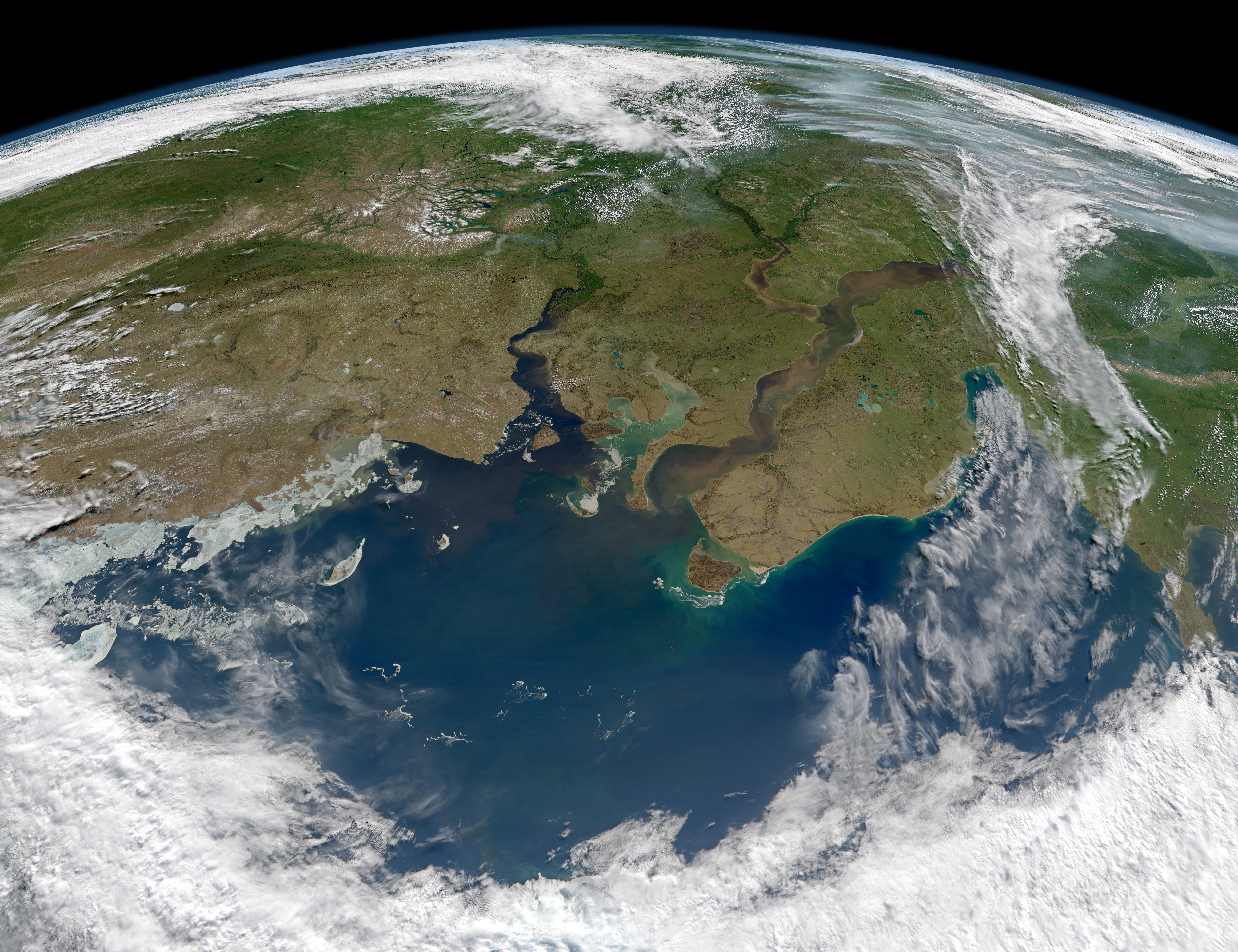
English: When rivers flow to the sea, they usually carry sediment and dissolved organic material—dead and decaying plant material—with them. The question for many Arctic researchers is how does that flow change from season to season, and how might it accelerate as far northern latitudes grow warmer.
The Ob and Yenisei Rivers in north-central Russia are among the larger rivers that drain into the Arctic Ocean, though past research suggested that they do not necessarily carry as much organic matter and sediment as other rivers. The Moderate Resolution Imaging Spectroradiometer (MODIS) aboard the Aqua satellite acquired this image of the rivers as they dumped tan sediments and dark brown dissolved organic material (DOM) into the Kara Sea on June 29, 2012. Note that the image is rotated to face southeast, such that the North Pole is off the bottom of the image.
Though the exact amount is not known, scientists believe much of the world's old organic carbon—the litter of thousands to millions of years of plants and trees—is stored in the soils and permafrost of the taiga, boreal forests, and watersheds of far northern latitudes. Plant matter decays far more slowly in the cold north, and much of it freezes into the soil. But as the world grows warmer, researchers suspect that more of this carbon will thaw and flow out into rivers and seas—such as the Ob, Yenisei and Kara—adding to the manmade carbon in our atmosphere and oceans. The effect of this dissolved carbon on temperatures and biological productivity in the ocean is an active research topic.
Researchers also keep an eye on the Kara Sea because the former Soviet Union once dumped nuclear materials into the shallow sea. According to a report from the Russian government, reactors, wastes, and spent fuel from nuclear submarines, icebreakers, and power plant reactors were disposed near Novaya Zemlya. To date, the International Atomic Energy Agency does not see the radiation levels posing a serious through to human or marine animal populations.
~ Earth Observatory
Русский: Енисей и Обь впадают в Карское Море. Снимок сделан инструментом MODIS со спутника Aqua.
Bu faylda fotoaparat və ya skanerlə əlavə olunmuş məlumatlar var. Əgər fayl sonradan redaktə olunubsa, bəzi parametrlər bu şəkildə göstərilənlərdən fərqli ola bilər.
JPEG şəkil şərhi
Satellite: Aqua
Sensor: MODIS Date: 29 June 2012 Description:
Southeastward view of the Kara Sea and the CDOM-and-suspended-sediment-laden Ob, Taz, and Yenisei estuaries.
Red channel: Band 1 (620-670 nm) Green channel: Band 4 (545-565 nm) Blue channel: Band 3 (459-479 nm) Projection:
tilted near-sided perspective from 892 kilometers above 77 North by 61 East
Projection details:
mapproject -Rd -JG61/77/1.14/130/43/0/40/40/65
Image created by: Norman Kuring
Yanvar 11, 2023
fayl, yenisei, kara, fayl, faylın, tarixçəsi, istifadə, edilən, səhifələr, faylın, qlobal, istifadəsi, metaməlumatlarsınaq, göstərişi, ölçüsü, piksel, digər, ölçülər, piksel, piksel, piksel, piksel, piksel, piksel, faylın, orijinalı, 8206, piksel, fayl, həcmi,. Fayl Faylin tarixcesi Istifade edilen sehifeler Faylin qlobal istifadesi MetamelumatlarSinaq gosterisi olcusu 780 600 piksel Diger olculer 312 240 piksel 624 480 piksel 999 768 piksel 1 280 985 piksel 2 560 1 969 piksel 6 500 5 000 piksel Faylin orijinali 8206 6 500 5 000 piksel fayl hecmi 9 77 MB MIME novu image jpeg Bu fayl Vikimedia Commons dadirve diger layihelerde istifade edile biler Faylin tesvir sehifesine get Xulase IzahYenisei Ob Kara Sea jpg English When rivers flow to the sea they usually carry sediment and dissolved organic material dead and decaying plant material with them The question for many Arctic researchers is how does that flow change from season to season and how might it accelerate as far northern latitudes grow warmer The Ob and Yenisei Rivers in north central Russia are among the larger rivers that drain into the Arctic Ocean though past research suggested that they do not necessarily carry as much organic matter and sediment as other rivers The Moderate Resolution Imaging Spectroradiometer MODIS aboard the Aqua satellite acquired this image of the rivers as they dumped tan sediments and dark brown dissolved organic material DOM into the Kara Sea on June 29 2012 Note that the image is rotated to face southeast such that the North Pole is off the bottom of the image Though the exact amount is not known scientists believe much of the world s old organic carbon the litter of thousands to millions of years of plants and trees is stored in the soils and permafrost of the taiga boreal forests and watersheds of far northern latitudes Plant matter decays far more slowly in the cold north and much of it freezes into the soil But as the world grows warmer researchers suspect that more of this carbon will thaw and flow out into rivers and seas such as the Ob Yenisei and Kara adding to the manmade carbon in our atmosphere and oceans The effect of this dissolved carbon on temperatures and biological productivity in the ocean is an active research topic Researchers also keep an eye on the Kara Sea because the former Soviet Union once dumped nuclear materials into the shallow sea According to a report from the Russian government reactors wastes and spent fuel from nuclear submarines icebreakers and power plant reactors were disposed near Novaya Zemlya To date the International Atomic Energy Agency does not see the radiation levels posing a serious through to human or marine animal populations Earth Observatory Russkij Enisej i Ob vpadayut v Karskoe More Snimok sdelan instrumentom MODIS so sputnika Aqua Tarix 19 avqust 2012Menbe http earthobservatory nasa gov IOTD view php id 78829Muellif NASA image courtesy Norman Kuring Ocean Color Web Instrument Aqua MODIS Lisenziya Public domain Public domain false falseThis file is in the public domain in the United States because it was solely created by NASA NASA copyright policy states that NASA material is not protected by copyright unless noted See Template PD USGov NASA copyright policy page or JPL Image Use Policy Warnings Use of NASA logos insignia and emblems is restricted per U S law 14 CFR 1221 The NASA website hosts a large number of images from the Soviet Russian space agency and other non American space agencies These are not necessarily in the public domain Materials based on Hubble Space Telescope data may be copyrighted if they are not explicitly produced by the STScI 1 See also PD Hubble and Cc Hubble The SOHO ESA amp NASA joint project implies that all materials created by its probe are copyrighted and require permission for commercial non educational use 2 Images featured on the Astronomy Picture of the Day APOD web site may be copyrighted 3 The National Space Science Data Center NSSDC site has been known to host copyrighted content Its photo gallery FAQ states that all of the images in the photo gallery are in the public domain Unless otherwise noted CaptionsazerbaycancaAdd a one line explanation of what this file representsItems portrayed in this filetesvir ediryaranma tarixi19 avqust 2012 Faylin tarixcesi Faylin evvelki versiyasini gormek ucun gun tarix bolmesindeki tarixlere klikleyin Tarix VaxtKicik sekilOlculerIstifadeciSerh indiki17 05 19 avqust 20126 500 5 000 9 77 MB Melikamp Istifade edilen sehifeler Bu sekile olan kecidler Ob cay Rusiya Yenisey Faylin qlobal istifadesi Bu fayl asagidaki vikilerde istifade olunur af wikipedia org layihesinde istifadesi Sowjetunie Ob Jenisei Karasee alt wikipedia org layihesinde istifadesi Op suu da wikipedia org layihesinde istifadesi Wikipedia Dagens skandinaviske artikel Nynorsk Uge 34 2017 de wikipedia org layihesinde istifadesi Waigatsch en wikipedia org layihesinde istifadesi Yenisey Ob river List of Ramsar sites in Russia io wikipedia org layihesinde istifadesi Maro Kara lfn wikipedia org layihesinde istifadesi Rio Ienisei ml wikipedia org layihesinde istifadesi യ ന സ നദ nn wikipedia org layihesinde istifadesi Karahavet Wikipedia Utvald artikkel 2017 Wikipedia Utvald artikkel Veke 34 2017 pl wikipedia org layihesinde istifadesi Jenisej Morze Karskie ru wikipedia org layihesinde istifadesi Ob Enisej sv wikipedia org layihesinde istifadesi Wikipedia Dagens skandinaviska artikel Nynorsk Vecka 34 2017 tr wikipedia org layihesinde istifadesi YeniseyMetamelumatlar Bu faylda fotoaparat ve ya skanerle elave olunmus melumatlar var Eger fayl sonradan redakte olunubsa bezi parametrler bu sekilde gosterilenlerden ferqli ola biler JPEG sekil serhiSatellite Aqua Sensor MODIS Date 29 June 2012 Description Southeastward view of the Kara Sea and the CDOM and suspended sediment laden Ob Taz and Yenisei estuaries Red channel Band 1 620 670 nm Green channel Band 4 545 565 nm Blue channel Band 3 459 479 nm Projection tilted near sided perspective from 892 kilometers above 77 North by 61 East Projection details mapproject Rd JG61 77 1 14 130 43 0 40 40 65 Image created by Norman Kuring Menbe https az wikipedia org wiki Fayl Yenisei Ob Kara Sea jpg, wikipedia, oxu, kitab, kitabxana, axtar, tap, hersey,
ne axtarsan burda
, en yaxsi meqale sayti, meqaleler, kitablar, oyrenmek, wiki, bilgi, tarix, seks, porno, indir, yukle, sex, azeri sex, azeri, seks yukle, sex yukle, izle, seks izle, porno izle, mobil seks, telefon ucun, chat, azeri chat, tanisliq, tanishliq, azeri tanishliq, sayt, medeni, medeni saytlar, chatlar, mekan, tanisliq mekani, mekanlari, yüklə, pulsuz, pulsuz yüklə, mp3, video, mp4, 3gp, jpg, jpeg, gif, png, şəkil, muisiqi, mahnı, kino, film, kitab, oyun, oyunlar.