Bu fayl "Vikimedia Commons"dadır və digər layihələrdə istifadə edilə bilər.
Faylın təsvir səhifəsinə get
This photograph was taken with a Nikon D90
Xülasə
İzahVitoshaPlateau-1.jpg
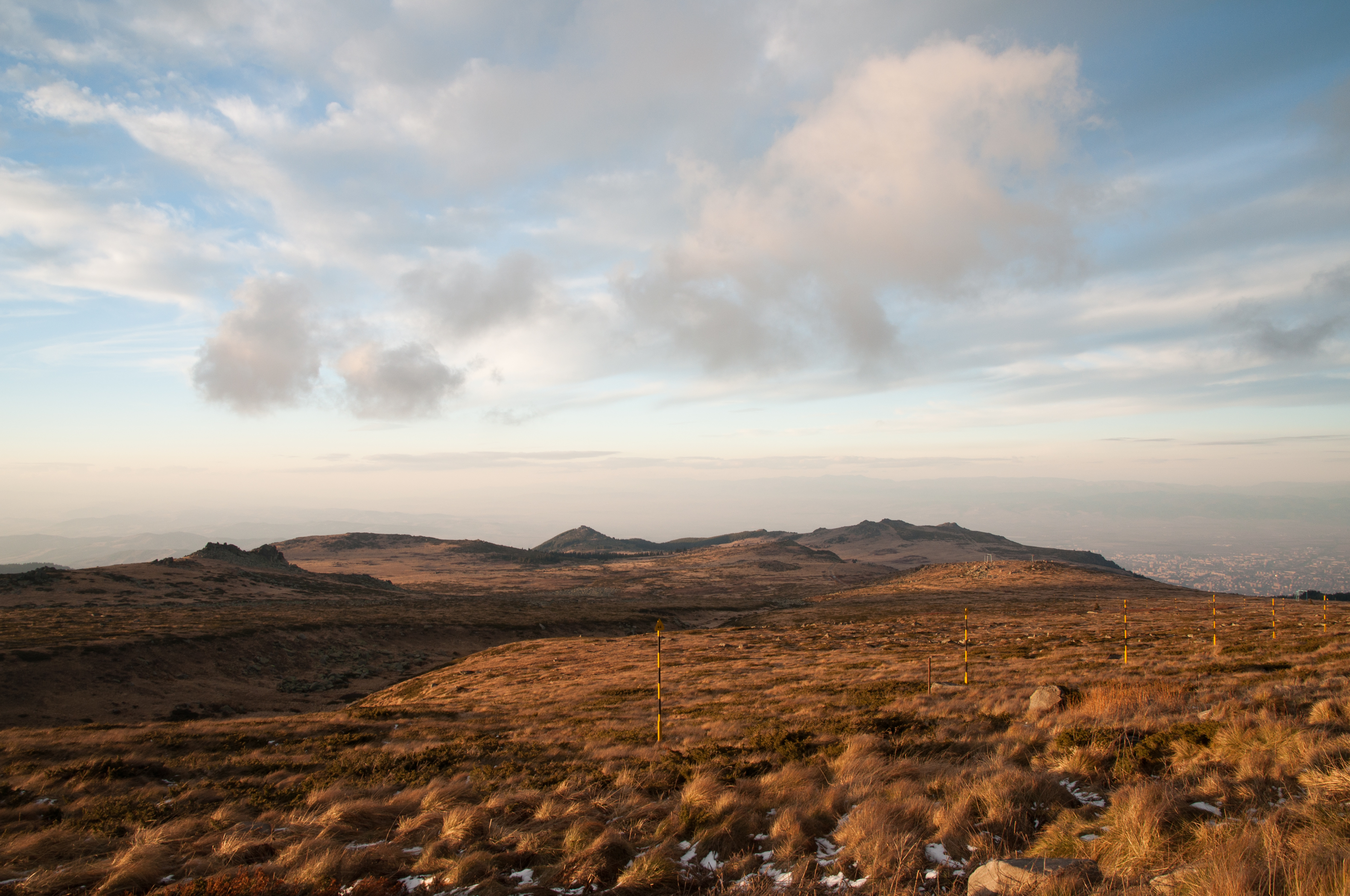
English: „Torfeno Branishte“ (Turf Reserve), the natural reserve on Vitosha Mountain, Bulgaria with the peak of „Ushite“ (1906 m) in the background and „Lavcheto peak“ (2053 m) in the closer left. The reserve spreads at average altitude of almost 2000 metres. The city of Sofia is visible in the far right background.
Български: Природният резерват „Торфено бранище“ на Витошкото плато, с връх „Ушите“ (1906 m) в дъното и връх „Лъвчето“ (2053 m) близко ляво. Резерватът се простира на средна надморска височина от почти 2000 метра. Град София се вижда в дъното в дясно.
Tarix
Mənbə
Öz işi
Müəllif
MrPanyGoff
Camera location
42° 34′ 18,45″ N, 23° 17′ 01,08″ E
View this and other nearby images on: OpenStreetMap
If you use some of my photos, an email to MrPanyGoff (account needed) or a message would be appreciated.
Do not copy this image illegally by ignoring the terms of the license below, as it is not in the public domain. If you would like special permission to use, license, or purchase the image please contact me to negotiate terms.
Plamen Agov • studiolemontree, the copyright holder of this work, hereby publishes it under the following licenses:
Bu fayl Creative Commons Attribution-Share Alike 3.0 Sinqapur lisenziyası altında yayımlanır.
İstinad: Plamen Agov • studiolemontree
Azadsınız:
paylaşmaq – əsəri köçürmək, paylamaq və ötürmək üçün
remiks etmək – əsəri adaptasiya etmək
Aşağıdakı şərtlərə riayət etməklə:
istinad – Müvafiq kredit verməlisiniz, lisenziyaya bir keçid verməlisiniz və dəyişikliklərin olub olmadığını bildirməlisiniz. Bunu hər hansı bir ağlabatan şəkildə edə bilərsiniz, ancaq lisenziyalaşdırıcının sizi və ya istifadənizi təsdiqləməsini təklif edən bir şəkildə deyil.
bənzər paylaşma – Əsəri remix edirsinizsə, dəyişdirirsinizsə və ya üzərində iş aparırsınızsa, öz töhfələrinizi orijinalda olduğu kimi eyni və ya uyğun lisenziya altında yayımlamalısınız.
Bu sənədi GNU Azad Sənədləşdirmə Lisenziyası, Versiya 1.2 və ya Azad Proqram Fondu tərəfindən nəşr olunan hər hansı sonrakı versiya şərtlərinə əsasən dəyişməz bölmələr, ön qapaq mətnləri və arxa qapaq mətnləri olmadan köçürmək, yayımlamaq və / və ya dəyişdirmək üçün icazə verilir; Lisenziyanın bir nüsxəsi GNU Azad Sənədləşdirmə Lisenziyası adlı hissəyə daxil edilmişdir.http://www.gnu.org/copyleft/fdl.htmlGFDLGNU Free Documentation Licensetruetrue
İstədiyiniz lisenziyanı seçə bilərsiniz.
Annotations
InfoField
This image is annotated: View the annotations at Commons
1996
1182
126
83
3162
2100
"Ushite peak" - 1906 metres above sea level
427
1242
285
138
3162
2100
"Lavcheto peak" - 2053 metres above sea level
2668
1258
478
99
3162
2100
Sofia City
2186
1147
972
67
3162
2100
The Balkan mountain range (Stara Planina)
Quality image
This image has been assessed using the Quality image guidelines and is considered a Quality image.
العربية ∙ جازايرية ∙ беларуская ∙ беларуская (тарашкевіца) ∙ български ∙ বাংলা ∙ català ∙ čeština ∙ Cymraeg ∙ Deutsch ∙ Schweizer Hochdeutsch ∙ Zazaki ∙ Ελληνικά ∙ English ∙ Esperanto ∙ español ∙ eesti ∙ euskara ∙ فارسی ∙ suomi ∙ français ∙ galego ∙ עברית ∙ हिन्दी ∙ hrvatski ∙ magyar ∙ հայերեն ∙ Bahasa Indonesia ∙ italiano ∙ 日本語 ∙ Jawa ∙ ქართული ∙ 한국어 ∙ kurdî ∙ Lëtzebuergesch ∙ lietuvių ∙ македонски ∙ മലയാളം ∙ मराठी ∙ Bahasa Melayu ∙ Nederlands ∙ Norfuk / Pitkern ∙ polski ∙ português ∙ português do Brasil ∙ rumantsch ∙ română ∙ русский ∙ sicilianu ∙ slovenčina ∙ slovenščina ∙ shqip ∙ српски / srpski ∙ svenska ∙ தமிழ் ∙ తెలుగు ∙ ไทย ∙ Tagalog ∙ Türkçe ∙ українська ∙ vèneto ∙ Tiếng Việt ∙ 中文 ∙ 中文(简体) ∙ 中文(繁體) ∙ +/−
Captions
Add a one-line explanation of what this file represents
{{Information |Description={{en|1=en:Torfeno Branishte (Turf Reserve), the natural reserve on en:Vitosha Mountain, Bulgaria with the peak of “Ushite” (1906 m) in the background and “Lavcheto peak” (2053 m) in the closer left. The reserve s
Bu faylda fotoaparat və ya skanerlə əlavə olunmuş məlumatlar var. Əgər fayl sonradan redaktə olunubsa, bəzi parametrlər bu şəkildə göstərilənlərdən fərqli ola bilər.
Kamera istehsalçısı
NIKON CORPORATION
Kamera modeli
NIKON D90
Exposure time
1/40 saniyə (0,025)
F nömrəsi
f/9
ISO sürət reytinqi
200
Orijinal tarix və vaxt
16:27, 21 noyabr 2010
Fokus məsafəsi
16 mm
Üfüqi xətt
300 dpi
Şaquli xətt
300 dpi
Proqram təminatı
Ver.1.00
Faylın dəyişməsi tarixi və vaxtı
15:07, 22 noyabr 2010
Ekspozisiya proqramı
Açıqlıq üstünlüyü
Exif versiyası
2.21
Tarix və vaxt rəqəmləşdirilir
16:27, 21 noyabr 2010
APEX shutter speed
5,321928
Obyektiv gözü
6,33985
APEX exposure bias
0
Maximum land aperture
3,6 APEX (f/3,48)
Metering mode
Dizaynlı
İşıq mənbəsi
Naməlum
Flaş
Flaş yandırılmadı
DateTimeOriginal subseconds
00
DateTimeDigitized subseconds
00
Sensing method
Birkristallı matrisli rəngli sensor
Custom image processing
Normal proses
Exposure mode
Avtomatik ekspozisiya
Ağ balansı
Bəyaz balansın avtomatik tənzimlənməsi
Digital zoom ratio
1
Focal length in 35 mm film
24 mm
Scene capture type
Standart
Kontrast
Normal
Doymuşluq
Normal
Kəskinlik
Normal
Subject distance range
Naməlum
Mart 05, 2023
fayl, vitoshaplateau, fayl, faylın, tarixçəsi, fayl, keçidləri, faylın, qlobal, istifadəsi, metaməlumatlarsınaq, göstərişi, ölçüsü, piksel, digər, ölçülər, piksel, piksel, piksel, piksel, piksel, piksel, faylın, orijinalı, 8206, piksel, fayl, həcmi, mime, növü. Fayl Faylin tarixcesi Fayl kecidleri Faylin qlobal istifadesi MetamelumatlarSinaq gosterisi olcusu 800 531 piksel Diger olculer 320 213 piksel 640 425 piksel 1 024 680 piksel 1 280 850 piksel 2 560 1 700 piksel 3 162 2 100 piksel Faylin orijinali 8206 3 162 2 100 piksel fayl hecmi 3 71 MB MIME novu image jpeg Bu fayl Vikimedia Commons dadirve diger layihelerde istifade edile biler Faylin tesvir sehifesine get nbsp This photograph was taken with a Nikon D90 Xulase IzahVitoshaPlateau 1 jpg English Torfeno Branishte Turf Reserve the natural reserve on Vitosha Mountain Bulgaria with the peak of Ushite 1906 m in the background and Lavcheto peak 2053 m in the closer left The reserve spreads at average altitude of almost 2000 metres The city of Sofia is visible in the far right background Blgarski Prirodniyat rezervat Torfeno branishe na Vitoshkoto plato s vrh Ushite 1906 m v dnoto i vrh Lvcheto 2053 m blizko lyavo Rezervatt se prostira na sredna nadmorska visochina ot pochti 2000 metra Grad Sofiya se vizhda v dnoto v dyasno Tarix 21 noyabr 2010 Menbe Oz isi Muellif MrPanyGoff Camera location42 nbsp 34 nbsp 18 45 nbsp N 23 nbsp 17 nbsp 01 08 nbsp E nbsp nbsp nbsp View this and other nearby images on OpenStreetMap42 571792 23 283633 Lisenziya This illustration was made byMrPanyGoff Please credit this nbsp c Plamen Agov studiolemontree in the immediate vicinity of the image If you use some of my photos an email to MrPanyGoff account needed or a message would be appreciated Do not copy this image illegally by ignoring the terms of the license below as it is not in the public domain If you would like special permission to use license or purchase the image please contact me to negotiate terms Plamen Agov studiolemontree the copyright holder of this work hereby publishes it under the following licenses Bu fayl Creative Commons Attribution Share Alike 3 0 Sinqapur lisenziyasi altinda yayimlanir Istinad Plamen Agov studiolemontreeAzadsiniz paylasmaq eseri kocurmek paylamaq ve oturmek ucun remiks etmek eseri adaptasiya etmek Asagidaki sertlere riayet etmekle istinad Muvafiq kredit vermelisiniz lisenziyaya bir kecid vermelisiniz ve deyisikliklerin olub olmadigini bildirmelisiniz Bunu her hansi bir aglabatan sekilde ede bilersiniz ancaq lisenziyalasdiricinin sizi ve ya istifadenizi tesdiqlemesini teklif eden bir sekilde deyil benzer paylasma Eseri remix edirsinizse deyisdirirsinizse ve ya uzerinde is aparirsinizsa oz tohfelerinizi orijinalda oldugu kimi eyni ve ya uygun lisenziya altinda yayimlamalisiniz https creativecommons org licenses by sa 3 0 CC BY SA 3 0 Creative Commons Attribution Share Alike 3 0 true true Bu senedi GNU Azad Senedlesdirme Lisenziyasi Versiya 1 2 ve ya Azad Proqram Fondu terefinden nesr olunan her hansi sonraki versiya sertlerine esasen deyismez bolmeler on qapaq metnleri ve arxa qapaq metnleri olmadan kocurmek yayimlamaq ve ve ya deyisdirmek ucun icaze verilir Lisenziyanin bir nusxesi GNU Azad Senedlesdirme Lisenziyasi adli hisseye daxil edilmisdir http www gnu org copyleft fdl html GFDL GNU Free Documentation License true trueIstediyiniz lisenziyani sece bilersiniz AnnotationsInfoFieldThis image is annotated View the annotations at Commons1996 1182 126 83 3162 2100 Ushite peak 1906 metres above sea level 427 1242 285 138 3162 2100 Lavcheto peak 2053 metres above sea level 2668 1258 478 99 3162 2100 Sofia City 2186 1147 972 67 3162 2100 The Balkan mountain range Stara Planina Quality image This image has been assessed using the Quality image guidelines and is considered a Quality image العربية nbsp جازايرية nbsp belaruskaya nbsp belaruskaya tarashkevica nbsp blgarski nbsp ব ল nbsp catala nbsp cestina nbsp Cymraeg nbsp Deutsch nbsp Schweizer Hochdeutsch nbsp Zazaki nbsp Ellhnika nbsp English nbsp Esperanto nbsp espanol nbsp eesti nbsp euskara nbsp فارسی nbsp suomi nbsp francais nbsp galego nbsp עברית nbsp ह न द nbsp hrvatski nbsp magyar nbsp հայերեն nbsp Bahasa Indonesia nbsp italiano nbsp 日本語 nbsp Jawa nbsp ქართული nbsp 한국어 nbsp kurdi nbsp Letzebuergesch nbsp lietuviu nbsp makedonski nbsp മലയ ള nbsp मर ठ nbsp Bahasa Melayu nbsp Nederlands nbsp Norfuk Pitkern nbsp polski nbsp portugues nbsp portugues do Brasil nbsp rumantsch nbsp romană nbsp russkij nbsp sicilianu nbsp slovencina nbsp slovenscina nbsp shqip nbsp srpski srpski nbsp svenska nbsp தம ழ nbsp త ల గ nbsp ithy nbsp Tagalog nbsp Turkce nbsp ukrayinska nbsp veneto nbsp Tiếng Việt nbsp 中文 nbsp 中文 简体 nbsp 中文 繁體 nbsp CaptionsazerbaycancaAdd a one line explanation of what this file representsItems portrayed in this filetesvir edirnatural landscape nbsp ingilisecoregion nbsp ingilisGoytepeBuluddaghighland nbsp ingilisyaradiciSome value without a Vikiverilenler itemobyektin rolu fotoqrafWikimedia username nbsp ingilis MrPanyGoffmuellifin qisa adi MrPanyGoffURL nbsp ingilis https commons wikimedia org wiki User MrPanyGoffcopyright status nbsp ingiliscopyrighted nbsp ingilislisenziyaCreative Commons Attribution ShareAlike 3 0 Unported nbsp ingilisGNU Free Documentation License version 1 2 or later nbsp ingilisCommons quality assessment nbsp ingilisWikimedia Commons quality image nbsp ingilissource of file nbsp ingilisoriginal creation by uploader nbsp ingilisyaranma tarixi21 noyabr 2010captured with nbsp ingilisNikon D90 nbsp ingiliscoordinates of the point of view nbsp ingilis42 34 18 451 N 23 17 1 079 Eheading nbsp ingilis 337 5 dereceexposure time nbsp ingilis0 025 saniyef number nbsp ingilis9focal length nbsp ingilis16 millimetrISO speed nbsp ingilis200anlayisin sinfifotoqrafiya Faylin tarixcesi Faylin evvelki versiyasini gormek ucun gun tarix bolmesindeki tarixlere klikleyin Tarix VaxtKicik sekilOlculerIstifadeciSerh indiki16 34 22 noyabr 20103 162 2 100 3 71 MB MrPanyGoff Information Description en 1 en Torfeno Branishte Turf Reserve the natural reserve on en Vitosha Mountain Bulgaria with the peak of Ushite 1906 m in the background and Lavcheto peak 2053 m in the closer left The reserve s Fayl kecidleri Bu sekile olan kecidler Torfeno Braniste Faylin qlobal istifadesi Bu fayl asagidaki vikilerde istifade olunur en wikipedia org layihesinde istifadesi Vitosha Torfeno Branishte fr wikipedia org layihesinde istifadesi Projet Impression Quality images 133 ja wikipedia org layihesinde istifadesi ヴィトシャ山 sq wikipedia org layihesinde istifadesi Torfeno Branishte sr wikipedia org layihesinde istifadesi Vitosha Torfeno Branishte tr wikipedia org layihesinde istifadesi Torfeno Braniste uk wikipedia org layihesinde istifadesi Zapovidnik Torfeno branishteMetamelumatlar Bu faylda fotoaparat ve ya skanerle elave olunmus melumatlar var Eger fayl sonradan redakte olunubsa bezi parametrler bu sekilde gosterilenlerden ferqli ola biler Kamera istehsalcisiNIKON CORPORATIONKamera modeliNIKON D90Exposure time1 40 saniye 0 025 F nomresif 9ISO suret reytinqi200Orijinal tarix ve vaxt16 27 21 noyabr 2010Fokus mesafesi16 mmUfuqi xett300 dpiSaquli xett300 dpiProqram teminatiVer 1 00Faylin deyismesi tarixi ve vaxti15 07 22 noyabr 2010Ekspozisiya proqramiAciqliq ustunluyuExif versiyasi2 21Tarix ve vaxt reqemlesdirilir16 27 21 noyabr 2010APEX shutter speed5 321928Obyektiv gozu6 33985APEX exposure bias0Maximum land aperture3 6 APEX f 3 48 Metering modeDizaynliIsiq menbesiNamelumFlasFlas yandirilmadiDateTimeOriginal subseconds00DateTimeDigitized subseconds00Sensing methodBirkristalli matrisli rengli sensorCustom image processingNormal prosesExposure modeAvtomatik ekspozisiyaAg balansiBeyaz balansin avtomatik tenzimlenmesiDigital zoom ratio1Focal length in 35 mm film24 mmScene capture typeStandartKontrastNormalDoymusluqNormalKeskinlikNormalSubject distance rangeNamelum Menbe https az wikipedia org wiki Fayl VitoshaPlateau 1 jpg, wikipedia, oxu, kitab, kitabxana, axtar, tap, hersey,
ne axtarsan burda
, en yaxsi meqale sayti, meqaleler, kitablar, oyrenmek, wiki, bilgi, tarix, seks, porno, indir, yukle, sex, azeri sex, azeri, seks yukle, sex yukle, izle, seks izle, porno izle, mobil seks, telefon ucun, chat, azeri chat, tanisliq, tanishliq, azeri tanishliq, sayt, medeni, medeni saytlar, chatlar, mekan, tanisliq mekani, mekanlari, yüklə, pulsuz, pulsuz yüklə, mp3, video, mp4, 3gp, jpg, jpeg, gif, png, şəkil, muisiqi, mahnı, kino, film, kitab, oyun, oyunlar.