Bu fayl "Vikimedia Commons"dadır və digər layihələrdə istifadə edilə bilər.
Faylın təsvir səhifəsinə get
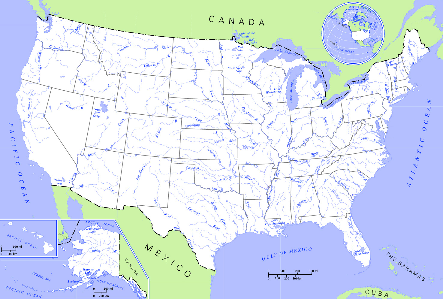
İzahUS map - rivers and lakes2.jpg
Rivers and Lakes in the United States. * Author: US Department of Interior * Source:http://nationalatlas.gov, there also available as PDF
Tarix
(UTC)
Mənbə
US_map_-_rivers_and_lakes.png
Müəllif
US Department of Interior
Bu təsvirin redaktəsi, orijinala əsaslanaraq rəqəmsal qaydadadır. Dəyişiklik: Changed hue to increase contrast and cropped the map. İlkin təsvir buradadır: US map - rivers and lakes.png. Redaktə etdi Monfornot.
Public domainPublic domainfalsefalse
https://creativecommons.org/publicdomain/mark/1.0/PDMCreative Commons Public Domain Mark 1.0falsefalse
Orijinal yükləmə gündəliyi
This image is a derivative work of the following images:
File:US_map_-_rivers_and_lakes.png licensed with PD-USGov
2004-11-12T15:11:08Z Duesentrieb 1584x1224 (308269 Bytes) Rivers and lakes in the US; Dept. of Interior, Public Domain
Uploaded with derivativeFX
Captions
Add a one-line explanation of what this file represents
Items portrayed in this file
təsvir edir
yaranma tarixi
2 yanvar 2009
Faylın tarixçəsi
Faylın əvvəlki versiyasını görmək üçün gün/tarix bölməsindəki tarixlərə klikləyin.
{{Information |Description=Rivers and Lakes in the United States. * '''Author:''' US Department of Interior * '''Source:''' http://nationalatlas.gov, there also available as PDF |Source=*File:US_map_-_rivers_and_lakes.png |Date=2009-01-02 21:0
Bu faylda fotoaparat və ya skanerlə əlavə olunmuş məlumatlar var. Əgər fayl sonradan redaktə olunubsa, bəzi parametrlər bu şəkildə göstərilənlərdən fərqli ola bilər.
_error
0
Yanvar 14, 2023
fayl, rivers, lakes2, fayl, faylın, tarixçəsi, istifadə, edilən, səhifələr, faylın, qlobal, istifadəsi, metaməlumatlarsınaq, göstərişi, ölçüsü, piksel, digər, ölçülər, piksel, piksel, piksel, piksel, faylın, orijinalı, 8206, piksel, fayl, həcmi, mime, növü, im. Fayl Faylin tarixcesi Istifade edilen sehifeler Faylin qlobal istifadesi MetamelumatlarSinaq gosterisi olcusu 800 540 piksel Diger olculer 320 216 piksel 640 432 piksel 1 024 691 piksel 1 476 996 piksel Faylin orijinali 8206 1 476 996 piksel fayl hecmi 559 KB MIME novu image jpeg Bu fayl Vikimedia Commons dadirve diger layihelerde istifade edile biler Faylin tesvir sehifesine get IzahUS map rivers and lakes2 jpg Rivers and Lakes in the United States Author US Department of Interior Source http nationalatlas gov there also available as PDFTarix 2 yanvar 2009 21 06 UTC Menbe US map rivers and lakes pngMuellif US Department of Interior Bu tesvirin redaktesi orijinala esaslanaraq reqemsal qaydadadir Deyisiklik Changed hue to increase contrast and cropped the map Ilkin tesvir buradadir US map rivers and lakes png Redakte etdi Monfornot Public domain Public domain false falseThis work is in the public domain in the United States because it is a work prepared by an officer or employee of the United States Government as part of that person s official duties under the terms of Title 17 Chapter 1 Section 105 of the US Code Note This only applies to original works of the Federal Government and not to the work of any individual U S state territory commonwealth county municipality or any other subdivision This template also does not apply to postage stamp designs published by the United States Postal Service since 1978 See 313 6 C 1 of Compendium of U S Copyright Office Practices It also does not apply to certain US coins see The US Mint Terms of Use This file has been identified as being free of known restrictions under copyright law including all related and neighboring rights https creativecommons org publicdomain mark 1 0 PDM Creative Commons Public Domain Mark 1 0 false falseOrijinal yukleme gundeliyi This image is a derivative work of the following images File US map rivers and lakes png licensed with PD USGov 2004 11 12T15 11 08Z Duesentrieb 1584x1224 308269 Bytes Rivers and lakes in the US Dept of Interior Public DomainUploaded with derivativeFXCaptionsazerbaycancaAdd a one line explanation of what this file representsItems portrayed in this filetesvir ediryaranma tarixi2 yanvar 2009 Faylin tarixcesi Faylin evvelki versiyasini gormek ucun gun tarix bolmesindeki tarixlere klikleyin Tarix VaxtKicik sekilOlculerIstifadeciSerh indiki21 12 2 yanvar 20091 476 996 559 KB Monfornot Information Description Rivers and Lakes in the United States 039 039 039 Author 039 039 039 US Department of Interior 039 039 039 Source 039 039 039 http nationalatlas gov there also available as PDF Source File US map rivers and lakes png Date 2009 01 02 21 0 Istifade edilen sehifeler Bu sekile olan kecidler ABS cografiyasi Faylin qlobal istifadesi Bu fayl asagidaki vikilerde istifade olunur be wikipedia org layihesinde istifadesi Geagrafiya ZShA bg wikipedia org layihesinde istifadesi Geografiya na Sedinenite amerikanski shati en wikipedia org layihesinde istifadesi User XanUltra sandbox hy wikipedia org layihesinde istifadesi Ամերիկայի Միացյալ Նահանգների աշխարհագրություն ru wikipedia org layihesinde istifadesi Geografiya SShAMetamelumatlar Bu faylda fotoaparat ve ya skanerle elave olunmus melumatlar var Eger fayl sonradan redakte olunubsa bezi parametrler bu sekilde gosterilenlerden ferqli ola biler error0 Menbe https az wikipedia org wiki Fayl US map rivers and lakes2 jpg, wikipedia, oxu, kitab, kitabxana, axtar, tap, hersey,
ne axtarsan burda
, en yaxsi meqale sayti, meqaleler, kitablar, oyrenmek, wiki, bilgi, tarix, seks, porno, indir, yukle, sex, azeri sex, azeri, seks yukle, sex yukle, izle, seks izle, porno izle, mobil seks, telefon ucun, chat, azeri chat, tanisliq, tanishliq, azeri tanishliq, sayt, medeni, medeni saytlar, chatlar, mekan, tanisliq mekani, mekanlari, yüklə, pulsuz, pulsuz yüklə, mp3, video, mp4, 3gp, jpg, jpeg, gif, png, şəkil, muisiqi, mahnı, kino, film, kitab, oyun, oyunlar.