Bu fayl "Vikimedia Commons"dadır və digər layihələrdə istifadə edilə bilər.
Faylın təsvir səhifəsinə get
Xülasə
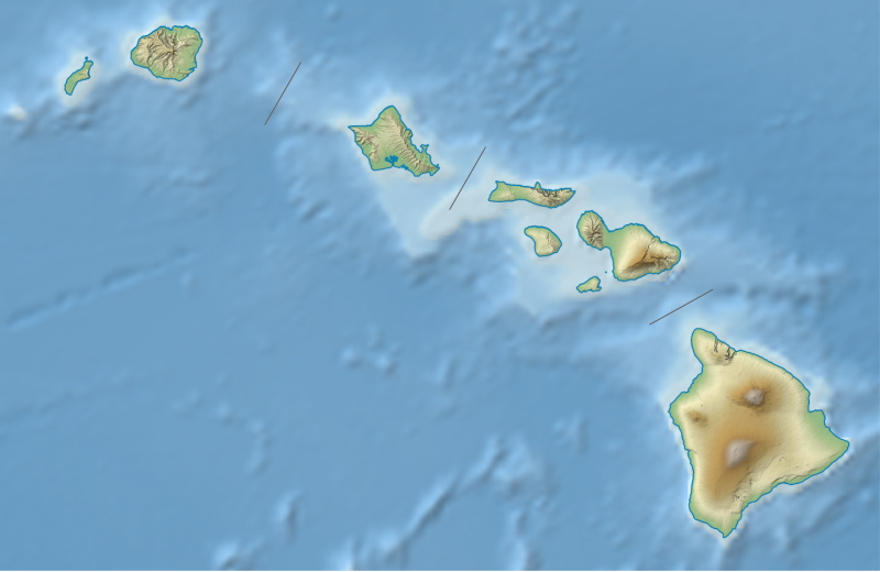
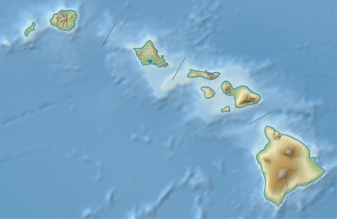
İzahUSA Hawaii relief location map.svg
Deutsch: Positionskarte von Hawaii, USA
Quadratische Plattkarte, N-S-Streckung 107 %. Geographische Begrenzung der Karte:
N: 22.4° N
S: 18.7° N
W: 160.7° W
O: 154.6° W
English: Location map of Hawaii, USA
Equirectangular projection, N/S stretching 107 %. Geographic limits of the map:
N: 22.4° N
S: 18.7° N
W: 160.7° W
E: 154.6° W
Tarix
Mənbə
own work, using
United States National Imagery and Mapping Agency data
U.S. Geological Survey (USGS) data
SRTM30 v.2 data
NGDC ETOPO2v2 data
Müəllif
NordNordWest
Digər versiyalar
administrative version
Bu xəritə alman Kartenwerkstatt tərəfindən yaxşılaşdırılmışdir. Siz həmçinin tələb olunan digər xəritələri də təklif edə bilərsiniz.
azərbaycanca ∙ Deutsch (Sie-Form) ∙ čeština ∙ Deutsch ∙ sicilianu ∙ italiano ∙ русский ∙ română ∙ português ∙ English ∙ magyar ∙ Nederlands ∙ slovenščina ∙ polski ∙ latviešu ∙ македонски ∙ español ∙ فارسی ∙ français ∙ suomi ∙ עברית ∙ Plattdüütsch ∙ ქართული ∙ հայերեն ∙ বাংলা ∙ ไทย ∙ 日本語 ∙ 中文 ∙ 中文(简体) ∙ 中文(繁體) ∙ العربية ∙ +/−
Lisenziya
Usage of this file with:
Map: NordNordWest, Licence: Creative Commons by-sa-3.0 de
explanatory notes: Legally binding is only the full legalcode. For a free usage I recommend to respect the following licence conditions: 1. Provide my name as given above: NordNordWest, 2. a copy of, or the URI for, the applicable license: https://creativecommons.org/licenses/by-sa/3.0/de/legalcode, 3. the title of the work, 4. in the case of an adaptation, a credit identifying the use of the work in the adaptation. This license and the rights granted hereunder will terminate automatically upon any breach by you of the terms of this license. Any of the above conditions can be waived if you get permission from the copyright holder. If you have questions or wish differing conditions, please contact me through nnwestt-online.de or my discussion page
Bu fayl Creative Commons Attribution-Share Alike 3.0 Almaniya lisenziyası altında yayımlanır.
İstinad: Karte: NordNordWest, Lizenz: Creative Commons by-sa-3.0 de
Azadsınız:
paylaşmaq – əsəri köçürmək, paylamaq və ötürmək üçün
remiks etmək – əsəri adaptasiya etmək
Aşağıdakı şərtlərə riayət etməklə:
istinad – Müvafiq kredit verməlisiniz, lisenziyaya bir keçid verməlisiniz və dəyişikliklərin olub olmadığını bildirməlisiniz. Bunu hər hansı bir ağlabatan şəkildə edə bilərsiniz, ancaq lisenziyalaşdırıcının sizi və ya istifadənizi təsdiqləməsini təklif edən bir şəkildə deyil.
bənzər paylaşma – Əsəri remix edirsinizsə, dəyişdirirsinizsə və ya üzərində iş aparırsınızsa, öz töhfələrinizi orijinalda olduğu kimi eyni və ya uyğun lisenziya altında yayımlamalısınız.
This file has been released under a license which is incompatible with Facebook's licensing terms. It is not permitted to upload this file to Facebook.
Captions
Add a one-line explanation of what this file represents
Items portrayed in this file
təsvir edir
copyright status ingilis
copyrighted ingilis
lisenziya
Creative Commons Attribution-ShareAlike 3.0 Germany ingilis
yaranma tarixi
3 avqust 2013
MIME type ingilis
image/svg+xml
Faylın tarixçəsi
Faylın əvvəlki versiyasını görmək üçün gün/tarix bölməsindəki tarixlərə klikləyin.
Bu faylda fotoaparat və ya skanerlə əlavə olunmuş məlumatlar var. Əgər fayl sonradan redaktə olunubsa, bəzi parametrlər bu şəkildə göstərilənlərdən fərqli ola bilər.
Genişlik
1440.954px
Hündürlük
935.188px
İyul 07, 2023
fayl, hawaii, relief, location, fayl, faylın, tarixçəsi, fayl, keçidləri, faylın, qlobal, istifadəsi, metaməlumatlarbu, faylın, formatındakı, görünüşünün, ölçüsü, piksel, digər, ölçülər, piksel, piksel, piksel, piksel, piksel, piksel, faylın, orijinalı, 8206, . Fayl Faylin tarixcesi Fayl kecidleri Faylin qlobal istifadesi MetamelumatlarBu SVG faylin PNG formatindaki bu gorunusunun olcusu 800 519 piksel Diger olculer 320 208 piksel 640 415 piksel 1 024 664 piksel 1 280 831 piksel 2 560 1 661 piksel 1 441 935 piksel Faylin orijinali 8206 SVG fayli nominal olaraq 1 441 935 piksel faylin olcusu 317 KB Bu fayl Vikimedia Commons dadirve diger layihelerde istifade edile biler Faylin tesvir sehifesine get Xulase IzahUSA Hawaii relief location map svg Deutsch Positionskarte von Hawaii USA Quadratische Plattkarte N S Streckung 107 nbsp Geographische Begrenzung der Karte N 22 4 N S 18 7 N W 160 7 W O 154 6 W English Location map of Hawaii USA Equirectangular projection N S stretching 107 nbsp Geographic limits of the map N 22 4 N S 18 7 N W 160 7 W E 154 6 W Tarix 3 avqust 2013 Menbe own work using United States National Imagery and Mapping Agency data U S Geological Survey USGS data SRTM30 v 2 data NGDC ETOPO2v2 data Muellif NordNordWest Diger versiyalar administrative version Bu xerite alman Kartenwerkstatt terefinden yaxsilasdirilmisdir Siz hemcinin teleb olunan diger xeriteleri de teklif ede bilersiniz azerbaycanca nbsp Deutsch Sie Form nbsp cestina nbsp Deutsch nbsp sicilianu nbsp italiano nbsp russkij nbsp romană nbsp portugues nbsp English nbsp magyar nbsp Nederlands nbsp slovenscina nbsp polski nbsp latviesu nbsp makedonski nbsp espanol nbsp فارسی nbsp francais nbsp suomi nbsp עברית nbsp Plattduutsch nbsp ქართული nbsp հայերեն nbsp ব ল nbsp ithy nbsp 日本語 nbsp 中文 nbsp 中文 简体 nbsp 中文 繁體 nbsp العربية nbsp Lisenziya Usage of this file with Map NordNordWest Licence Creative Commons by sa 3 0 de explanatory notes Legally binding is only the full legalcode For a free usage I recommend to respect the following licence conditions 1 Provide my name as given above NordNordWest 2 a copy of or the URI for the applicable license https creativecommons org licenses by sa 3 0 de legalcode 3 the title of the work 4 in the case of an adaptation a credit identifying the use of the work in the adaptation This license and the rights granted hereunder will terminate automatically upon any breach by you of the terms of this license Any of the above conditions can be waived if you get permission from the copyright holder If you have questions or wish differing conditions please contact me through span class nowrap nnwestt online de span or my discussion pageBu fayl Creative Commons Attribution Share Alike 3 0 Almaniya lisenziyasi altinda yayimlanir Istinad Karte NordNordWest Lizenz Creative Commons by sa 3 0 deAzadsiniz paylasmaq eseri kocurmek paylamaq ve oturmek ucun remiks etmek eseri adaptasiya etmek Asagidaki sertlere riayet etmekle istinad Muvafiq kredit vermelisiniz lisenziyaya bir kecid vermelisiniz ve deyisikliklerin olub olmadigini bildirmelisiniz Bunu her hansi bir aglabatan sekilde ede bilersiniz ancaq lisenziyalasdiricinin sizi ve ya istifadenizi tesdiqlemesini teklif eden bir sekilde deyil benzer paylasma Eseri remix edirsinizse deyisdirirsinizse ve ya uzerinde is aparirsinizsa oz tohfelerinizi orijinalda oldugu kimi eyni ve ya uygun lisenziya altinda yayimlamalisiniz https creativecommons org licenses by sa 3 0 de deed en CC BY SA 3 0 de Creative Commons Attribution Share Alike 3 0 de true true This file has been released under a license which is incompatible with Facebook s licensing terms It is not permitted to upload this file to Facebook CaptionsazerbaycancaAdd a one line explanation of what this file representsItems portrayed in this filetesvir edircopyright status nbsp ingiliscopyrighted nbsp ingilislisenziyaCreative Commons Attribution ShareAlike 3 0 Germany nbsp ingilisyaranma tarixi3 avqust 2013MIME type nbsp ingilisimage svg xml Faylin tarixcesi Faylin evvelki versiyasini gormek ucun gun tarix bolmesindeki tarixlere klikleyin Tarix VaxtKicik sekilOlculerIstifadeciSerh indiki19 22 3 avqust 20131 441 935 317 KB NordNordWestbrighter 19 10 3 avqust 20131 441 935 331 KB NordNordWest Information Description de Positionskarte von Hawaii USA Quadratische Plattkarte N S Streckung 107 Geographische Begrenzung der Karte N 22 4 N S 18 7 N W 160 7 W O 154 6 W en Location map o Fayl kecidleri Bu sekile olan kecidler Havay adalari Kau sehrasi Sablon Yer xeritesi Amerika Birlesmis Statlari Havay Faylin qlobal istifadesi Bu fayl asagidaki vikilerde istifade olunur ar wikipedia org layihesinde istifadesi قالب خريطة مواقع الولايات المتحدة هاواي زلزال هاواي 2018 كاو كريتر ast wikipedia org layihesinde istifadesi Modulu Minimapa data Ḥawai Modulu Minimapa data Ḥawai usu azb wikipedia org layihesinde istifadesi پیو یووی هاوایی bg wikipedia org layihesinde istifadesi Honolulu Hilo Makauao Prl Siti Havai Shablon PK SASh Havai Vulkani na Havai nacionalen park Haleakala nacionalen park bn wikipedia org layihesinde istifadesi মড উল অবস থ ন ম নচ ত র উপ ত ত হ ওয ই মড উল অবস থ ন ম নচ ত র উপ ত ত হ ওয ই নথ মড উল অবস থ ন ম নচ ত র উপ ত ত ম র ক ন য ক তর ষ ট র হ ওয ই মড উল অবস থ ন ম নচ ত র উপ ত ত ম র ক ন য ক তর ষ ট র হ ওয ই নথ ca wikipedia org layihesinde istifadesi Modul Location map data USA Hawaii Modul Location map data USA Hawaii us ceb wikipedia org layihesinde istifadesi Plantilya Location map USA Hawaii ce wikipedia org layihesinde istifadesi Kep Mettigan karta ACSh Gavajsh Kilba malhbalen gӀajrenash ckb wikipedia org layihesinde istifadesi ڕوانگەی جێمینی cs wikipedia org layihesinde istifadesi Mauna Loa Mauna Kea Kilauea Sablona LocMap Havaj Hualalai Diamond Head Haleakala Narodni park Haleakala Narodni park Havajske vulkany Kaʻala de wikipedia org layihesinde istifadesi Mauna Loa Mauna Kea Kama ehuakanaloa Kohala Kilauea Hawaiʻi Volcanoes Nationalpark Haleakala Nationalpark Diamond Head Hawaii Haleakala Hualalai Mauna Kamakou Punchbowl Crater Molokini Marinefunkstelle Lualualei Puʻu ʻŌʻō Waiʻaleʻale Kaʻula Manana Bu faylin qlobal istifadesine baxin Metamelumatlar Bu faylda fotoaparat ve ya skanerle elave olunmus melumatlar var Eger fayl sonradan redakte olunubsa bezi parametrler bu sekilde gosterilenlerden ferqli ola biler Genislik1440 954pxHundurluk935 188px Menbe https az wikipedia org wiki Fayl USA Hawaii relief location map svg, wikipedia, oxu, kitab, kitabxana, axtar, tap, hersey,
ne axtarsan burda
, en yaxsi meqale sayti, meqaleler, kitablar, oyrenmek, wiki, bilgi, tarix, seks, porno, indir, yukle, sex, azeri sex, azeri, seks yukle, sex yukle, izle, seks izle, porno izle, mobil seks, telefon ucun, chat, azeri chat, tanisliq, tanishliq, azeri tanishliq, sayt, medeni, medeni saytlar, chatlar, mekan, tanisliq mekani, mekanlari, yüklə, pulsuz, pulsuz yüklə, mp3, video, mp4, 3gp, jpg, jpeg, gif, png, şəkil, muisiqi, mahnı, kino, film, kitab, oyun, oyunlar.