Bu fayl "Vikimedia Commons"dadır və digər layihələrdə istifadə edilə bilər.
Faylın təsvir səhifəsinə get
Xülasə
İzahUN Palestine Partition Versions 1947.jpg
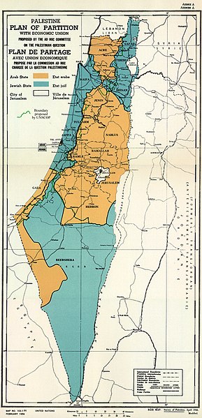
English: February 1956 Map of UN Partition Plan for Palestine, adopted 29 Nov 1947, with boundary of previous UNSCOP partition plan added in green.
العربية: خريطة رسمية بعد قرار الأمم المتحدة بتاريخ 29 نوفمبر 1947م بتقسيم فلسطين إلى دولة عربية ويهودية وتحويل القدس لمدينة دولية.
Tarix
Mənbə
m0103_1b.gif on PLAN OF PARTITION is from UNGA Resolution 181 (27 Nov 1947). Overdrawn UNSCOP boundary is from United Nations Special Committee on Palestine, Report to the General Assembly, 3 Sep 1947, Volume II, A/364, Add. 1.
Müəllif
Zero0000A/RES/181(II)
Digər versiyalar
This file has multiple extracted images:
The area around Isdud and Majdal in the UN Palestine Partition Versions 1947 (cropped).jpg
Northern Arab State in the UN Palestine Partition Versions 1947 (cropped).jpg
Central area of the Arab State in the UN Palestine Partition Versions 1947 (cropped).jpg
Beersheba in the Arab State in the UN Palestine Partition Versions 1947 (cropped).jpg
Copyright status of map:
Public domainPublic domainfalsefalse
Lisenziya
I, the copyright holder of this work, hereby publish it under the following license:
Bu fayl Creative Commons Attribution-Share Alike 3.0 Sinqapur lisenziyası altında yayımlanır.
Azadsınız:
paylaşmaq – əsəri köçürmək, paylamaq və ötürmək üçün
remiks etmək – əsəri adaptasiya etmək
Aşağıdakı şərtlərə riayət etməklə:
istinad – Müvafiq kredit verməlisiniz, lisenziyaya bir keçid verməlisiniz və dəyişikliklərin olub olmadığını bildirməlisiniz. Bunu hər hansı bir ağlabatan şəkildə edə bilərsiniz, ancaq lisenziyalaşdırıcının sizi və ya istifadənizi təsdiqləməsini təklif edən bir şəkildə deyil.
bənzər paylaşma – Əsəri remix edirsinizsə, dəyişdirirsinizsə və ya üzərində iş aparırsınızsa, öz töhfələrinizi orijinalda olduğu kimi eyni və ya uyğun lisenziya altında yayımlamalısınız.
This historical map image could be re-created using vector graphics as an SVG file. This has several advantages; see Commons:Media for cleanup for more information. If an SVG form of this image is available, please upload it and afterwards replace this template with {{vector version available|new image name}}. It is recommended to name the SVG file "UN Palestine Partition Versions 1947.svg" – then the template Vector version available (or Vva) does not need the new image name parameter.
This historical map image was uploaded in the JPEG format even though it consists of non-photographic data. This information could be stored more efficiently or accurately in the PNG or SVG format. If possible, please upload a PNG or SVG version of this image without compression artifacts, derived from a non-JPEG source (or with existing artifacts removed). After doing so, please tag the JPEG version with {{Superseded|NewImage.ext}} and remove this tag. This tag should not be applied to photographs or scans. For more information, see {{BadJPEG}}.
Captions
Add a one-line explanation of what this file represents
Items portrayed in this file
təsvir edir
copyright status ingilis
copyrighted ingilis
lisenziya
Creative Commons Attribution-ShareAlike 3.0 Unported ingilis
yaranma tarixi
10 avqust 2013
MIME type ingilis
image/jpeg
Faylın tarixçəsi
Faylın əvvəlki versiyasını görmək üçün gün/tarix bölməsindəki tarixlərə klikləyin.
fayl, palestine, partition, versions, 1947, fayl, faylın, tarixçəsi, istifadə, edilən, səhifələr, faylın, qlobal, istifadəsisınaq, göstərişi, ölçüsü, piksel, digər, ölçülər, piksel, piksel, piksel, piksel, piksel, faylın, orijinalı, 8206, piksel, fayl, həcmi, . Fayl Faylin tarixcesi Istifade edilen sehifeler Faylin qlobal istifadesiSinaq gosterisi olcusu 289 599 piksel Diger olculer 116 240 piksel 231 480 piksel 370 768 piksel 494 1 024 piksel 1 370 2 838 piksel Faylin orijinali 8206 1 370 2 838 piksel fayl hecmi 1 46 MB MIME novu image jpeg Bu fayl Vikimedia Commons dadirve diger layihelerde istifade edile biler Faylin tesvir sehifesine get Xulase IzahUN Palestine Partition Versions 1947 jpg English February 1956 Map of UN Partition Plan for Palestine adopted 29 Nov 1947 with boundary of previous UNSCOP partition plan added in green العربية خريطة رسمية بعد قرار الأمم المتحدة بتاريخ 29 نوفمبر 1947م بتقسيم فلسطين إلى دولة عربية ويهودية وتحويل القدس لمدينة دولية Tarix 10 avqust 2013 22 04 13Menbe m0103 1b gif on PLAN OF PARTITION is from UNGA Resolution 181 27 Nov 1947 Overdrawn UNSCOP boundary is from United Nations Special Committee on Palestine Report to the General Assembly 3 Sep 1947 Volume II A 364 Add 1 Muellif Zero0000A RES 181 II Diger versiyalar This file has multiple extracted images The area around Isdud and Majdal in the UN Palestine Partition Versions 1947 cropped jpgNorthern Arab State in the UN Palestine Partition Versions 1947 cropped jpgCentral area of the Arab State in the UN Palestine Partition Versions 1947 cropped jpgBeersheba in the Arab State in the UN Palestine Partition Versions 1947 cropped jpg Copyright status of map Public domain Public domain false falseThis image is a map derived from a United Nations map Unless stated otherwise UN maps are to be considered in the public domain This applies worldwide Some UN maps have special copyrights as indicated on the map itself UN maps are in principle open source material and you can use them in your work or for making your own map UN requests however that you delete the UN name logo and reference number upon any modification to the map Content of your map will be your responsibility You can state in your publication if you wish something like based on UN map map name map number revision number and date See The UN Cartographic Section retrieved 16 November 2013 Lisenziya I the copyright holder of this work hereby publish it under the following license Bu fayl Creative Commons Attribution Share Alike 3 0 Sinqapur lisenziyasi altinda yayimlanir Azadsiniz paylasmaq eseri kocurmek paylamaq ve oturmek ucun remiks etmek eseri adaptasiya etmek Asagidaki sertlere riayet etmekle istinad Muvafiq kredit vermelisiniz lisenziyaya bir kecid vermelisiniz ve deyisikliklerin olub olmadigini bildirmelisiniz Bunu her hansi bir aglabatan sekilde ede bilersiniz ancaq lisenziyalasdiricinin sizi ve ya istifadenizi tesdiqlemesini teklif eden bir sekilde deyil benzer paylasma Eseri remix edirsinizse deyisdirirsinizse ve ya uzerinde is aparirsinizsa oz tohfelerinizi orijinalda oldugu kimi eyni ve ya uygun lisenziya altinda yayimlamalisiniz https creativecommons org licenses by sa 3 0 CC BY SA 3 0 Creative Commons Attribution Share Alike 3 0 true true This historical map image could be re created using vector graphics as an SVG file This has several advantages see Commons Media for cleanup for more information If an SVG form of this image is available please upload it and afterwards replace this template with vector version available i new image name i It is recommended to name the SVG file UN Palestine Partition Versions 1947 svg then the template Vector version available or Vva does not need the new image name parameter This historical map image was uploaded in the JPEG format even though it consists of non photographic data This information could be stored more efficiently or accurately in the PNG or SVG format If possible please upload a PNG or SVG version of this image without compression artifacts derived from a non JPEG source or with existing artifacts removed After doing so please tag the JPEG version with Superseded NewImage ext and remove this tag This tag should not be applied to photographs or scans For more information see BadJPEG CaptionsazerbaycancaAdd a one line explanation of what this file representsItems portrayed in this filetesvir edircopyright status ingiliscopyrighted ingilislisenziyaCreative Commons Attribution ShareAlike 3 0 Unported ingilisyaranma tarixi10 avqust 2013MIME type ingilisimage jpeg Faylin tarixcesi Faylin evvelki versiyasini gormek ucun gun tarix bolmesindeki tarixlere klikleyin Tarix VaxtKicik sekilOlculerIstifadeciSerh indiki12 07 10 avqust 20131 370 2 838 1 46 MB Zero0000User created page with UploadWizard Istifade edilen sehifeler Bu sekile olan kecidler Ereb Israil muharibesi 1948 Faylin qlobal istifadesi Bu fayl asagidaki vikilerde istifade olunur ar wikipedia org layihesinde istifadesi قرار تقسيم فلسطين الاعتراف الدولي بإسرائيل الخط الزمني للصراع العربي الإسرائيلي رقابة حدودية azb wikipedia org layihesinde istifadesi عرب ایسرائیل ساواشی ۱۹۴۸ bg wikipedia org layihesinde istifadesi Plan na OON za razdelyane na Palestina bn wikipedia org layihesinde istifadesi জ ত স ঘ র ফ ল স ত ন ব ভ গ পর কল পন cdo wikipedia org layihesinde istifadesi Wikipedia Dŏng nieng gĭng dang 11 nguŏk Wikipedia Dŏng nieng gĭng dang 11 nguŏk 29 ho cy wikipedia org layihesinde istifadesi Rhyfel Arabiaid Israeliaid 1948 de wikipedia org layihesinde istifadesi Konigreich Agypten el wikipedia org layihesinde istifadesi Arabo israhlinos polemos toy 1948 en wikipedia org layihesinde istifadesi 1948 Arab Israeli War United Nations Partition Plan for Palestine International zone International city Israel Arab localities in Israel Template talk Largest cities of Israel Talk 1947 1948 civil war in Mandatory Palestine Archive 2 Wikipedia Editor assistance Requests Archive 122 Talk Israel Archive 47 Talk Israel Archive 49 Talk Jerusalem Archive 25 Talk Religion in Israel Archive 1 Wikipedia talk Noticeboard for India related topics Archive 74 es wikipedia org layihesinde istifadesi UNSCOP et wikipedia org layihesinde istifadesi Araabia Iisraeli soda fa wikipedia org layihesinde istifadesi یافا fi wikipedia org layihesinde istifadesi Israelin itsenaisyyssota Palestiinan mandaattialueen sisallissota Yhdistyneiden kansakuntien Palestiinan jakosuunnitelma fr wikipedia org layihesinde istifadesi Cisjordanie Plan de partage de la Palestine Guerre israelo arabe de 1948 1949 Corpus separatum Jerusalem ha wikipedia org layihesinde istifadesi Yaƙin Larabawa Isra ila 1948 hy wikipedia org layihesinde istifadesi Իսրայել ՄԱԿ ի Պաղեստինյան նախագիծ Մասնակից TamaraSargsyan Ավազարկղ id wikipedia org layihesinde istifadesi Rencana Pembagian Perserikatan Bangsa Bangsa untuk Palestina it wikipedia org layihesinde istifadesi Sionismo Piano di partizione della Palestina ja wikipedia org layihesinde istifadesi エジプトの歴史 パレスチナ分割決議 ko wikipedia org layihesinde istifadesi 팔레스타인 분할안 ml wikipedia org layihesinde istifadesi അറബ ഇസ രയ ൽ യ ദ ധ 1948 nl wikipedia org layihesinde istifadesi Geschiedenis van de staat Palestina Tweestatenoplossing no wikipedia org layihesinde istifadesi Corpus separatum Bu faylin qlobal istifadesine baxin Menbe https az wikipedia org wiki Fayl UN Palestine Partition Versions 1947 jpg, wikipedia, oxu, kitab, kitabxana, axtar, tap, hersey,
ne axtarsan burda
, en yaxsi meqale sayti, meqaleler, kitablar, oyrenmek, wiki, bilgi, tarix, seks, porno, indir, yukle, sex, azeri sex, azeri, seks yukle, sex yukle, izle, seks izle, porno izle, mobil seks, telefon ucun, chat, azeri chat, tanisliq, tanishliq, azeri tanishliq, sayt, medeni, medeni saytlar, chatlar, mekan, tanisliq mekani, mekanlari, yüklə, pulsuz, pulsuz yüklə, mp3, video, mp4, 3gp, jpg, jpeg, gif, png, şəkil, muisiqi, mahnı, kino, film, kitab, oyun, oyunlar.