Bu fayl "Vikimedia Commons"dadır və digər layihələrdə istifadə edilə bilər.
təsvir səhifəsi
Faylın təsvir səhifəsinə get
İzahTribal Kingdom of Samo-sl version.PNG
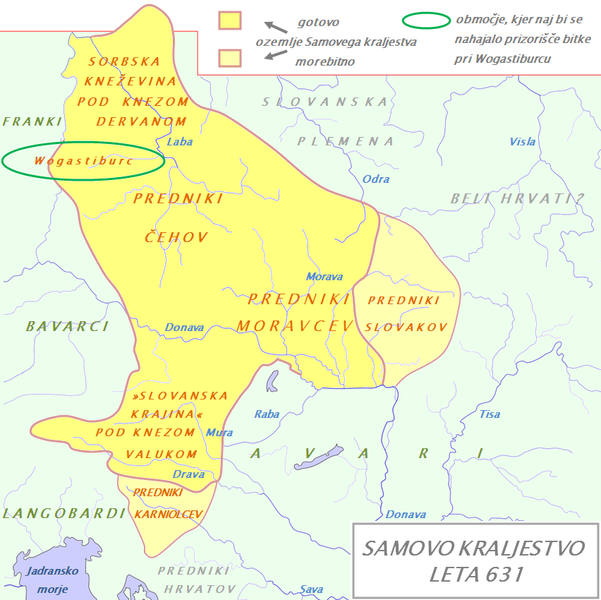
English: Tribal Kingdom of Samo. Map is based on the maps in: Korošec, Paola (1990): Alpski Slovani- Die Alpenslawen, Ljubljana, Znanstveni institut Filozofske fakultete, unnamed map on the page 18; Šavli, Jožko (1995): Sovenija: Podoba evropskega naroda, Bilje, založba Humar, map Samovo kraljestvo on the page 19; Barford, Paul M. (2001): The Early Slavs, Cornell University Press, map on the page 356, named Geography of the Slav settlement of Polabia- concerning the location of Sorbs east of Saale; map IV on page 397 for Sorbian culture, Devinska-Nova ves culture and Avarian state. It is also based on descriptions in: Štih, Peter (2001): Ozemlje Slovenije v zgodnjem srednjem veku: osnovne poteze zgodovinskega razvoja od začetka 6. do konca 9. stoletja, Ljubljana, Filozofska fakulteta; page 30- concerning the relationsship between king Samo and the ancestros of Slovenians; Korošec, Paola (1990): Alpski Slovani- Die Alpenslawen, Ljubljana, Znanstveni institut Filozofske fakultete, page 17 – concerning the Sorbs and their duke Dervan. For eastern and southern extant of tribal kingdom: known territories are shown by the scheme of franco-slavic border and information about the conflicts with Avars is imlemented. The inclusion of Bohemian basin is followed. Contacts with Avars are reached through the territory of Moravians anf Eastern Alps. The territories further east and south, which are in proximity of Avars, could be parts of tribal kingdom, too.
Tarix
(UTC)
Mənbə
Waterways_of_SE_Central_Europe.svg
Müəllif
Waterways_of_SE_Central_Europe.svg: Kmiki87
derivative work: Bostjan46 (talk)
Bu təsvirin redaktəsi, orijinala əsaslanaraq rəqəmsal qaydadadır. Dəyişiklik: The map of Danube basin was used to create map of Kingdom of Samo. İlkin təsvir buradadır: Waterways of SE Central Europe.svg. Redaktə etdi Bostjan46.
I, the copyright holder of this work, hereby publish it under the following license:
Public domainPublic domainfalsefalse
Orijinal yükləmə gündəliyi
This image is a derivative work of the following images:
File:Waterways_of_SE_Central_Europe.svg licensed with PD-self
2010-01-08T20:49:27Z Kmiki87 1415x1059 (292577 Bytes) {{Information |Description={{en|1=Waterways along the central and lower Danube, including the Bohemian and Carpathian Basins, the northern Balkans, parts of Austria, southern Poland and Western Ukraine.}} |Source={{own}} |Aut
Uploaded with derivativeFX
Captions
Add a one-line explanation of what this file represents
Items portrayed in this file
təsvir edir
copyright status ingilis
copyrighted, dedicated to the public domain by copyright holder ingilis
copyrighted ingilis
lisenziya
released into the public domain by the copyright holder ingilis
yaranma tarixi
9 yanvar 2011
Faylın tarixçəsi
Faylın əvvəlki versiyasını görmək üçün gün/tarix bölməsindəki tarixlərə klikləyin.
{{Information |Description={{en|1=Tribal Kingdom of Samo. Map is based on the maps in: Korošec, Paola (1990): ''Alpski Slovani- Die Alpenslawen'', Ljubljana, Znanstveni institut Filozofske fakultete, unnamed map on the page 18; Šavli, Jožko (1995): ''
fayl, tribal, kingdom, samo, version, fayl, faylın, tarixçəsi, fayl, keçidləri, faylın, qlobal, istifadəsisınaq, göstərişi, ölçüsü, piksel, digər, ölçülər, piksel, piksel, piksel, faylın, orijinalı, 8206, piksel, fayl, həcmi, mime, növü, image, fayl, vikimedia. Fayl Faylin tarixcesi Fayl kecidleri Faylin qlobal istifadesiSinaq gosterisi olcusu 601 600 piksel Diger olculer 241 240 piksel 481 480 piksel 852 850 piksel Faylin orijinali 8206 852 850 piksel fayl hecmi 149 KB MIME novu image png Bu fayl Vikimedia Commons dadirve diger layihelerde istifade edile biler tesvir sehifesi Faylin tesvir sehifesine get IzahTribal Kingdom of Samo sl version PNG English Tribal Kingdom of Samo Map is based on the maps in Korosec Paola 1990 Alpski Slovani Die Alpenslawen Ljubljana Znanstveni institut Filozofske fakultete unnamed map on the page 18 Savli Jozko 1995 Sovenija Podoba evropskega naroda Bilje zalozba Humar map Samovo kraljestvo on the page 19 Barford Paul M 2001 The Early Slavs Cornell University Press map on the page 356 named Geography of the Slav settlement of Polabia concerning the location of Sorbs east of Saale map IV on page 397 for Sorbian culture Devinska Nova ves culture and Avarian state It is also based on descriptions in Stih Peter 2001 Ozemlje Slovenije v zgodnjem srednjem veku osnovne poteze zgodovinskega razvoja od zacetka 6 do konca 9 stoletja Ljubljana Filozofska fakulteta page 30 concerning the relationsship between king Samo and the ancestros of Slovenians Korosec Paola 1990 Alpski Slovani Die Alpenslawen Ljubljana Znanstveni institut Filozofske fakultete page 17 concerning the Sorbs and their duke Dervan For eastern and southern extant of tribal kingdom known territories are shown by the scheme of franco slavic border and information about the conflicts with Avars is imlemented The inclusion of Bohemian basin is followed Contacts with Avars are reached through the territory of Moravians anf Eastern Alps The territories further east and south which are in proximity of Avars could be parts of tribal kingdom too Tarix 9 yanvar 2011 17 11 UTC Menbe Waterways of SE Central Europe svg Muellif Waterways of SE Central Europe svg Kmiki87 derivative work Bostjan46 talk Bu tesvirin redaktesi orijinala esaslanaraq reqemsal qaydadadir Deyisiklik The map of Danube basin was used to create map of Kingdom of Samo Ilkin tesvir buradadir Waterways of SE Central Europe svg Redakte etdi Bostjan46 nbsp I the copyright holder of this work hereby publish it under the following license Public domain Public domain false false Men bu eserin muellif huquqlarinin sahibi kimi eseri ictimai mulkiyyete verirem Bu icaze butun dunyada quvvededir In some countries this may not be legally possible if so Bunun qanunla mumkun olmadigi hallarda Istenilen sexse istenilen meqsed ucun qanunlar terefinden qadagan edilmeyince hec bir sert qoymadan bu isden istifade haqqini bagislayiram Orijinal yukleme gundeliyi This image is a derivative work of the following images File Waterways of SE Central Europe svg licensed with PD self 2010 01 08T20 49 27Z Kmiki87 1415x1059 292577 Bytes Information Description en 1 Waterways along the central and lower Danube including the Bohemian and Carpathian Basins the northern Balkans parts of Austria southern Poland and Western Ukraine Source own Aut Uploaded with derivativeFXCaptionsazerbaycancaAdd a one line explanation of what this file representsItems portrayed in this filetesvir edircopyright status nbsp ingiliscopyrighted dedicated to the public domain by copyright holder nbsp ingiliscopyrighted nbsp ingilislisenziyareleased into the public domain by the copyright holder nbsp ingilisyaranma tarixi9 yanvar 2011 Faylin tarixcesi Faylin evvelki versiyasini gormek ucun gun tarix bolmesindeki tarixlere klikleyin Tarix VaxtKicik sekilOlculerIstifadeciSerh indiki18 21 9 yanvar 2011852 850 149 KB Bostjan46The text for Dalmatian Slavs was changed Slavic tribes under avarian rule gt gt Ancestors of Croats 17 13 9 yanvar 2011852 850 150 KB Bostjan46 Information Description en 1 Tribal Kingdom of Samo Map is based on the maps in Korosec Paola 1990 039 039 Alpski Slovani Die Alpenslawen 039 039 Ljubljana Znanstveni institut Filozofske fakultete unnamed map on the page 18 Savli Jozko 1995 039 039 Fayl kecidleri Bu sekile olan kecidler Samo dovleti Faylin qlobal istifadesi Bu fayl asagidaki vikilerde istifade olunur be wikipedia org layihesinde istifadesi Dzyarvan bg wikipedia org layihesinde istifadesi Samo de wikipedia org layihesinde istifadesi Portal Diskussion Geschichte Archiv 2011 Benutzer Methodios Geschichte von Nisani Benutzer Methodios Weisse Serben gl wikipedia org layihesinde istifadesi Dervano lt wikipedia org layihesinde istifadesi Vogastisburgo musis pl wikipedia org layihesinde istifadesi Panstwo Samona Derwan Historia Slowenii Waluk ru wikipedia org layihesinde istifadesi Samo Dervan sl wikipedia org layihesinde istifadesi Karantanija Samo kralj Samova plemenska zveza Valuk Prihod Hrvatov Dervan sr wikipedia org layihesinde istifadesi Dervan sv wikipedia org layihesinde istifadesi Sloveniens historia szl wikipedia org layihesinde istifadesi Panstwo Samuna Menbe https az wikipedia org wiki Fayl Tribal Kingdom of Samo sl version PNG, wikipedia, oxu, kitab, kitabxana, axtar, tap, hersey,
ne axtarsan burda
, en yaxsi meqale sayti, meqaleler, kitablar, oyrenmek, wiki, bilgi, tarix, seks, porno, indir, yukle, sex, azeri sex, azeri, seks yukle, sex yukle, izle, seks izle, porno izle, mobil seks, telefon ucun, chat, azeri chat, tanisliq, tanishliq, azeri tanishliq, sayt, medeni, medeni saytlar, chatlar, mekan, tanisliq mekani, mekanlari, yüklə, pulsuz, pulsuz yüklə, mp3, video, mp4, 3gp, jpg, jpeg, gif, png, şəkil, muisiqi, mahnı, kino, film, kitab, oyun, oyunlar.