Bu fayl "Vikimedia Commons"dadır və digər layihələrdə istifadə edilə bilər.
Faylın təsvir səhifəsinə get
Xülasə
İzahTokyo L7 lrg.jpg
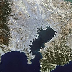
English: This false-color Landsat 7 image shows (a large part of) the greater Tokyo metropolitan area, situated on the eastern shore of the Japanese island of Honshu. The large Tokyo Bay dominates the center of this scene, and if you look closely you can see boats and their wakes on the water. The greater Tokyo area fans out in a crescent shape around the western, northern, and eastern shores of Tokyo Bay. Greater Tokyo is bordered to the west by rugged mountains and to the east by the vast expanse of the Pacific Ocean. The greater metropolis area is comprised of Tokyo prefecture, situated on the northwestern shore of Tokyo Bay, and the three neighboring prefectures of Kanagawa to the south, Saitama to the north, and Chiba to the east and southeast across Tokyo Bay. Over the last 400 years, Japan’s National Capital Region has evolved into a large, self-governing unit consisting of 26 cities, 5 towns, and 8 villages. The region is home to some 38 million people in 2018 (more than a quarter of Japan’s whole population) in a metropolitan area spanning 14,034 square km.
Bu faylda fotoaparat və ya skanerlə əlavə olunmuş məlumatlar var. Əgər fayl sonradan redaktə olunubsa, bəzi parametrlər bu şəkildə göstərilənlərdən fərqli ola bilər.
_error
0
May 13, 2023
fayl, tokyo, fayl, faylın, tarixçəsi, fayl, keçidləri, faylın, qlobal, istifadəsi, metaməlumatlarsınaq, göstərişi, ölçüsü, piksel, digər, ölçülər, piksel, piksel, piksel, faylın, orijinalı, 8206, piksel, fayl, həcmi, mime, növü, image, jpeg, fayl, vikimedia, c. Fayl Faylin tarixcesi Fayl kecidleri Faylin qlobal istifadesi MetamelumatlarSinaq gosterisi olcusu 600 600 piksel Diger olculer 240 240 piksel 480 480 piksel 1 000 1 000 piksel Faylin orijinali 8206 1 000 1 000 piksel fayl hecmi 511 KB MIME novu image jpeg Bu fayl Vikimedia Commons dadirve diger layihelerde istifade edile biler Faylin tesvir sehifesine get Xulase IzahTokyo L7 lrg jpg English This false color Landsat 7 image shows a large part of the greater Tokyo metropolitan area situated on the eastern shore of the Japanese island of Honshu The large Tokyo Bay dominates the center of this scene and if you look closely you can see boats and their wakes on the water The greater Tokyo area fans out in a crescent shape around the western northern and eastern shores of Tokyo Bay Greater Tokyo is bordered to the west by rugged mountains and to the east by the vast expanse of the Pacific Ocean The greater metropolis area is comprised of Tokyo prefecture situated on the northwestern shore of Tokyo Bay and the three neighboring prefectures of Kanagawa to the south Saitama to the north and Chiba to the east and southeast across Tokyo Bay Over the last 400 years Japan s National Capital Region has evolved into a large self governing unit consisting of 26 cities 5 towns and 8 villages The region is home to some 38 million people in 2018 more than a quarter of Japan s whole population in a metropolitan area spanning 14 034 square km 日本語 東京湾の衛星画像 2002年 人工衛星 NASA Earth Observatory による Tarix 11 oktyabr 2002 Menbe Earth Observatory Muellif Image courtesy Ron Beck USGS Eros Data Center Satellite Systems Branch Lisenziya Public domain Public domain false false This file is in the public domain in the United States because it was solely created by NASA NASA copyright policy states that NASA material is not protected by copyright unless noted See Template PD USGov NASA copyright policy page or JPL Image Use Policy Warnings Use of NASA logos insignia and emblems is restricted per U S law 14 CFR 1221 The NASA website hosts a large number of images from the Soviet Russian space agency and other non American space agencies These are not necessarily in the public domain Materials based on Hubble Space Telescope data may be copyrighted if they are not explicitly produced by the STScI 1 See also PD Hubble and Cc Hubble The SOHO ESA amp NASA joint project implies that all materials created by its probe are copyrighted and require permission for commercial non educational use 2 Images featured on the Astronomy Picture of the Day APOD web site may be copyrighted 3 The National Space Science Data Center NSSDC site has been known to host copyrighted content Its photo gallery FAQ states that all of the images in the photo gallery are in the public domain Unless otherwise noted CaptionsazerbaycancaAdd a one line explanation of what this file representsingilisSatellite photo of Tokyo Bay 2002 yapon東京湾の衛星写真 2002年 Items portrayed in this filetesvir ediryaranma tarixi11 oktyabr 2002 Faylin tarixcesi Faylin evvelki versiyasini gormek ucun gun tarix bolmesindeki tarixlere klikleyin Tarix VaxtKicik sekilOlculerIstifadeciSerh indiki14 25 18 noyabr 20081 000 1 000 511 KB Jyusin Information Description en 1 Tokyo ja 1 東京 Source http earthobservatory nasa gov IOTD view php id 2854 Earth Observatory Author NASA Date Permission other versions lt ImageUpload full gt Fayl kecidleri Bu sekile olan kecidler Aqlomerasiya regionu Faylin qlobal istifadesi Bu fayl asagidaki vikilerde istifade olunur de wikipedia org layihesinde istifadesi Bucht von Tokio es wikipedia org layihesinde istifadesi Aglomeracion urbana Bahia de Tokio fr wikipedia org layihesinde istifadesi Baie de Tokyo hu wikipedia org layihesinde istifadesi Tokioi obol it wikipedia org layihesinde istifadesi Baia di Tokyo ja wikipedia org layihesinde istifadesi 東京湾 南関東直下地震 pt wikipedia org layihesinde istifadesi Metropole simple wikipedia org layihesinde istifadesi Tokyo Bay tr wikipedia org layihesinde istifadesi Metropoliten alan vi wikipedia org layihesinde istifadesi Vịnh Tokyo zh wikipedia org layihesinde istifadesi 關東地方Metamelumatlar Bu faylda fotoaparat ve ya skanerle elave olunmus melumatlar var Eger fayl sonradan redakte olunubsa bezi parametrler bu sekilde gosterilenlerden ferqli ola biler error0 Menbe https az wikipedia org wiki Fayl Tokyo L7 lrg jpg, wikipedia, oxu, kitab, kitabxana, axtar, tap, hersey,
ne axtarsan burda
, en yaxsi meqale sayti, meqaleler, kitablar, oyrenmek, wiki, bilgi, tarix, seks, porno, indir, yukle, sex, azeri sex, azeri, seks yukle, sex yukle, izle, seks izle, porno izle, mobil seks, telefon ucun, chat, azeri chat, tanisliq, tanishliq, azeri tanishliq, sayt, medeni, medeni saytlar, chatlar, mekan, tanisliq mekani, mekanlari, yüklə, pulsuz, pulsuz yüklə, mp3, video, mp4, 3gp, jpg, jpeg, gif, png, şəkil, muisiqi, mahnı, kino, film, kitab, oyun, oyunlar.