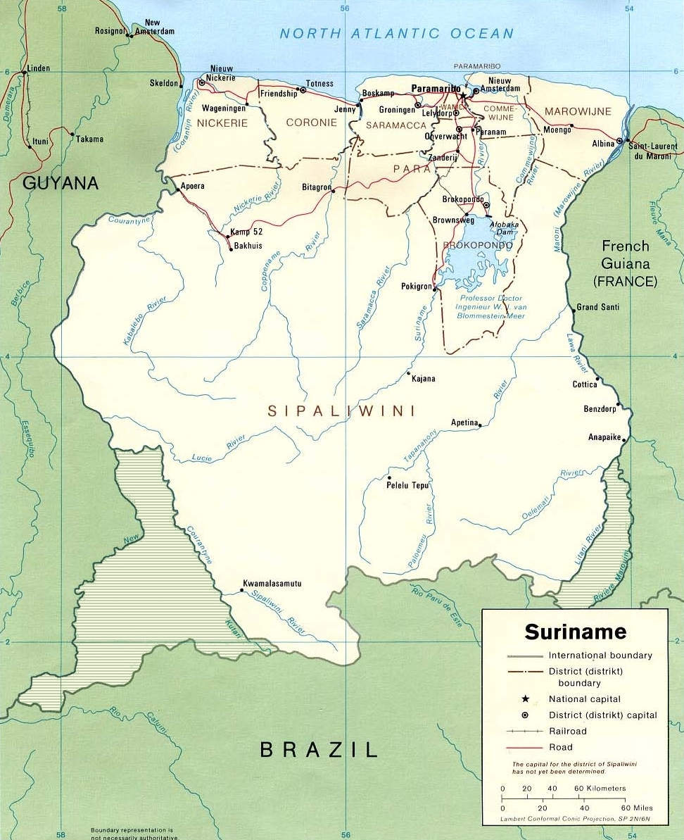
fayl, suriname1991, karte, umstrittene, gebiete, fayl, faylın, tarixçəsi, fayl, keçidləri, faylın, qlobal, istifadəsisınaq, göstərişi, ölçüsü, piksel, digər, ölçülər, piksel, piksel, piksel, faylın, orijinalı, 8206, piksel, fayl, həcmi, mime, növü, image, jpeg. Fayl Faylin tarixcesi Fayl kecidleri Faylin qlobal istifadesiSinaq gosterisi olcusu 488 599 piksel Diger olculer 195 240 piksel 391 480 piksel 972 1 193 piksel Faylin orijinali 8206 972 1 193 piksel fayl hecmi 712 KB MIME novu image jpeg Bu fayl Vikimedia Commons dadirve diger layihelerde istifade edile biler Faylin tesvir sehifesine get Land kaart Xulase IzahSuriname1991 Karte umstrittene Gebiete jpg English Edited CIA map of Suriname Deutsch Uberarbeitete CIA Karte Suriname einschliesslich in Grau der mit Guyana und Franzosisch Guayana umstrittenen Gebiete Nederlands CIA kaart van Suriname uit 1991 met toegevoegde betwiste gebieden Tarix 1991 Menbe Originally from de wikipedia description page is was here Muellif Original uploader was Benutzer Brokopondo at de wikipedia Icaze Faylin tekrar istifadesi PD according to LoC Edited by Benutzer Brokopondo and released under PD Diger versiyalar Derivative works of this file nbsp Brokopondo Reservoir png Lisenziya Public domain Public domain false false This image is a work of a Central Intelligence Agency employee taken or made as part of that person s official duties As a Work of the United States Government this image or media is in the public domain in the United States cestina nbsp Deutsch nbsp eesti nbsp English nbsp espanol nbsp francais nbsp italiano nbsp portugues nbsp polski nbsp sicilianu nbsp slovenscina nbsp suomi nbsp Tiếng Việt nbsp blgarski nbsp makedonski nbsp russkij nbsp ukrayinska nbsp ব ল nbsp മലയ ള nbsp 한국어 nbsp 日本語 nbsp 中文 nbsp 中文 简体 nbsp 中文 繁體 nbsp العربية nbsp پښتو nbsp Public domain Public domain false false This work has been released into the public domain by its author Brokopondo at alman Vikipediya This applies worldwide In some countries this may not be legally possible if so Brokopondo grants anyone the right to use this work for any purpose without any conditions unless such conditions are required by law Public domain Public domain false false Orijinal yukleme gundeliyi All user names refer to de wikipedia 11 51 14 Jun 2006 CEST Benutzer Brokopondo 1078 1300 568 Kbytes CaptionsazerbaycancaAdd a one line explanation of what this file representshollandCIA kaart van Suriname uit 1991 met toegevoegde betwiste gebiedenItems portrayed in this filetesvir edircopyright status nbsp ingiliscopyrighted dedicated to the public domain by copyright holder nbsp ingilislisenziyareleased into the public domain by the copyright holder nbsp ingilisyaranma tarixi1991MIME type nbsp ingilisimage jpeg Faylin tarixcesi Faylin evvelki versiyasini gormek ucun gun tarix bolmesindeki tarixlere klikleyin Tarix VaxtKicik sekilOlculerIstifadeciSerh indiki17 40 12 oktyabr 2021972 1 193 712 KB LojweCropped 10 horizontally 8 vertically using CropTool with precise mode 16 43 12 noyabr 20071 078 1 300 568 KB Hu Totya 16 20 12 noyabr 2007497 599 49 KB Szajci Information Description Karte Suriname Source Originally from http de wikipedia org de wikipedia description page is was http de wikipedia org w index php title Bild Suriname1991 Karte umstrittene Gebiete jpg here Date Author Original upl Fayl kecidleri Bu sekile olan kecidler Surinam Faylin qlobal istifadesi Bu fayl asagidaki vikilerde istifade olunur af wikipedia org layihesinde istifadesi Suriname ar wikipedia org layihesinde istifadesi خزان بروكوبوندو ceb wikipedia org layihesinde istifadesi Professor Doctor Ingenieur W J van Blommestein Meer Coppename Rivier de wikipedia org layihesinde istifadesi Suriname Liste der Flusse in Suriname en wikipedia org layihesinde istifadesi Borders of Suriname Brazil Suriname border eo wikipedia org layihesinde istifadesi Surinamo es wikipedia org layihesinde istifadesi Surinam Rio Surinam Rio Coppename Anexo Rios de Surinam fi wikipedia org layihesinde istifadesi Luettelo Surinamen kaupungeista fr wikipedia org layihesinde istifadesi Suriname Coppename Itany Saramacca fleuve Corentyne Frontiere entre le Guyana et le Suriname Projet Cartographie Cartes standards Pays Histoire de la culture des plantes sucrieres Brokopondo reservoir Lawa riviere Liste des cours d eau du Suriname Frontieres du Suriname fy wikipedia org layihesinde istifadesi Suriname it wikipedia org layihesinde istifadesi Confine tra la Guyana e il Suriname Confini del Suriname mg wikipedia org layihesinde istifadesi Sorinama ms wikipedia org layihesinde istifadesi Senarai bandar di Suriname nl wikipedia org layihesinde istifadesi Brokopondostuwmeer Overleg Wikipedia Wikiproject Suriname Saramacca rivier Commewijne rivier Coppename Avontuur in Suriname Overleg Wikipedia Wikiproject Suriname Archief 1 Suriname Litani Zuid Amerika Lijst van rivieren in Suriname Nieuwe Rivier Grenzen van Suriname Rits geologie Lijst van vissen in Suriname Grens tussen Brazilie en Suriname Overleg Wikipedia Wikiproject Suriname Archief 3 pl wikipedia org layihesinde istifadesi Surinam Wikipedysta Malarz pl szablony Panstwo infobox Wikipedysta Malarz pl szablony Panstwo infobox 2 Bu faylin qlobal istifadesine baxin Menbe https az wikipedia org wiki Fayl Suriname1991 Karte umstrittene Gebiete jpg, wikipedia, oxu, kitab, kitabxana, axtar, tap, hersey,
ne axtarsan burda
, en yaxsi meqale sayti, meqaleler, kitablar, oyrenmek, wiki, bilgi, tarix, seks, porno, indir, yukle, sex, azeri sex, azeri, seks yukle, sex yukle, izle, seks izle, porno izle, mobil seks, telefon ucun, chat, azeri chat, tanisliq, tanishliq, azeri tanishliq, sayt, medeni, medeni saytlar, chatlar, mekan, tanisliq mekani, mekanlari, yüklə, pulsuz, pulsuz yüklə, mp3, video, mp4, 3gp, jpg, jpeg, gif, png, şəkil, muisiqi, mahnı, kino, film, kitab, oyun, oyunlar.