Bu fayl "Vikimedia Commons"dadır və digər layihələrdə istifadə edilə bilər.
Faylın təsvir səhifəsinə get
This file was a candidate in Picture of the Year 2006. This file was the picture of the day on yanvar 12, 2005. This is a featured picture on Wikimedia Commons (Featured pictures) and is considered one of the finest images.
Vikipediya
This is a featured picture on the alman language Wikipedia (Exzellente Bilder) and is considered one of the finest images. This is a featured picture on the ingilis language Wikipedia (Featured pictures) and is considered one of the finest images. This is a featured picture on the ispan language Wikipedia (Recursos destacados) and is considered one of the finest images. This is a featured picture on the rumın language Wikipedia (Imagini de calitate) and is considered one of the finest images. This is a featured picture on the türk language Wikipedia (Seçkin resimler) and is considered one of the finest images.
If you have an image of similar quality that can be published under a suitable copyright license, be sure to upload it, tag it, and nominate it.
This image was selected as picture of the day on Wikimedia Commons for 12 January 2005. It was captioned as follows:
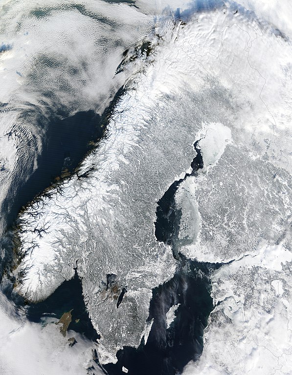
English: Scandinavia from space in winter.
Other languages:
Čeština: Zimní Skandinávie při pohledu z vesmíru
Dansk: Satellitbillede af Skandinavien om vinteren.
Deutsch: Winterliches Skandinavien aus dem Weltraum gesehen
English: Scandinavia from space in winter.
Español : La Península Escandinava en invierno vista desde el espacio
Esperanto: Skandinavio de spaco vintre.
Français : Vue depuis orbite terrestre de la péninsule scandinave en hiver.
Italiano : Vista della Scandinavia innevata dallo spazio.
Nederlands: Satellietfoto van Scandinavië in de winter
Norsk bokmål: Satelittbilde av Skandinavia om vinteren.
Polski: Skandynawia widziana z kosmosu w czasie zimy.
Português: Escandinávia vista do espaço no inverno.
Română: Scandinavia din spațiu, iarna
Suomi: Kuva talvisesta Fenno-Skandiasta ja Baltiasta avaruudesta kuvattuna
Svenska: Satellitbild på ett vintrigt Skandinavien
Türkçe: İskandinavya'nın kışın uzaydan uydu aracılığıyla çekilmiş bir görüntüsü.
한국어: 스칸디나비아의 위성사진.
日本語: スカンジナビアの衛星写真
Xülasə
İzahScandinavia.TMO2003050.jpg
English: Scandinavia from space in winter.
The Moderate Resolution Imaging Spectroradiometer (MODIS) instrument aboard NASA’s Terra satellite captured the above image of the Scandinavian Peninsula on February 19, 2003. With a landscape largely shaped by glaciers over the last ice age, the Scandinavian Peninsula is as picturesque in the winter as it is cold. Along the left side of the peninsula, one can see the jagged inlets, known as fjords, lining Norway’s coast. Many of these fjords are well over 2,000 feet (610 meters) deep and were carved out by extremely heavy, thick glaciers that formed during the last ice age. The glaciers ran off the mountains and scoured troughs into Norway’s coastline with depths that reached well below sea level. When the glaciers melted, the seawater rushed into these deep troughs to form the fjords. The deepest fjord on Norway’s coast, known as Sogn Fjord, lies in southwest Norway and is 4,291 feet (1,308 m) deep.
Glaciers also carved the mountains in Norway and northernmost Sweden. South of this mountainous region, however, Sweden consists mostly of flat, heavily forested land dotted with lakes. Lake Vänern and Lake Vättern, the largest of Sweden’s lakes, do not freeze completely during the winter months and can be seen clearly at the bottom of the peninsula. Lake Vättern, the smaller of the two lakes, was connected to the Baltic Sea during the last ice age. After the ice melted, a tremendous weight was lifted off of the peninsula, and the landmass rose up to separate the lake from the Baltic Sea. To the northeast of the peninsula lies Finland with more than 55,000 lakes, most of which were also created by glacial deposits.
Español: Escandinavia en invierno, imagen de la NASA
Français : Scandinavie en hiver depuis l'espace. Image prise par l'instrument MODIS à bord du satellite Terra de la NASA.
Avec ses paysages sculptés par les glaciers du quaternaire, la Scandinavie en hiver est aussi pittoresque que froide. À l'ouest sont visibles les étroits bras de mer appelés fjords, qui ponctuent la côte norvégienne. Ces fjords très profonds (plus de 600 m et jusque 1 308 m dans le Sognefjord) ont été creusés par de lourds glaciers au cours des âges glaciaires. Ces glaciers descendus de la montagne ont creusé leurs vallées bien en dessous du niveau de la mer. À la fin de la glaciation, c'est donc la mer qui a envahi ces profondes vallées.
Au sud de ces montagnes, la Suède est un pays de plaines couvertes de forêts et de lacs. Les deux plus grands lacs de Suède, les lacs Vänern et Vättern, sont aisément visibles au sud car ils ne sont pas pris par les glaces en hiver. Le plus petit de ces deux lacs, le lac Vättern, était une baie de la mer baltique peu après la dernière glaciation. Après la fonte des glaces, et le retrait de leur poids énorme sur la péninsule, celle-ci s'est relevée et le lac a été séparé de la mer. Au nord est de la péninsule se trouve la Finlande, pays aux 55 000 lacs, souvent d'origine glaciaire.
Nederlands: Satellietopname van Noorwegen, Zweden en Finland in de winter
Română: Peninsula Sandinavă în timpul iernii — vedere din satelit (19 februarie 2003).
Русский: Скандинавский полуостров зимой (19 февраля 2003)
Svenska: Satellitbild över Skandinavien. I Norge finns det fjordar, i Sverige sjöar och i Finland också. Hela halvön är täckt av snö på vintern. Även om det är kallt om vintern nu, så var det ännu kallare på istiden.
Jacques Descloitres, MODIS Land Rapid Response Team at NASA GSFC
İcazə (Faylın təkrar istifadəsi)
Quote of http://rapidfire.sci.gsfc.nasa.gov/faq/ - All the images that appear on our site are in the public domain and can be freely used and reproduced for any purpose. Please credit the MODIS Rapid Response Project appropriately: "Image courtesy of MODIS Rapid Response Project at NASA/GSFC".
Lisenziya
Public domainPublic domainfalsefalse
Captions
Add a one-line explanation of what this file represents
Scandinavia from space in winter.
Items portrayed in this file
təsvir edir
buz
Qış
Yer
Commons quality assessment ingilis
Wikimedia Commons featured picture ingilis
yaranma tarixi
19 fevral 2003
MIME type ingilis
image/jpeg
Faylın tarixçəsi
Faylın əvvəlki versiyasını görmək üçün gün/tarix bölməsindəki tarixlərə klikləyin.
fayl, scandinavia, tmo2003050, fayl, faylın, tarixçəsi, istifadə, edilən, səhifələr, faylın, qlobal, istifadəsisınaq, göstərişi, ölçüsü, piksel, digər, ölçülər, piksel, piksel, piksel, piksel, piksel, piksel, faylın, orijinalı, 8206, piksel, fayl, həcmi, mime,. Fayl Faylin tarixcesi Istifade edilen sehifeler Faylin qlobal istifadesiSinaq gosterisi olcusu 466 599 piksel Diger olculer 187 240 piksel 373 480 piksel 597 768 piksel 796 1 024 piksel 1 593 2 048 piksel 5 600 7 200 piksel Faylin orijinali 8206 5 600 7 200 piksel fayl hecmi 7 42 MB MIME novu image jpeg Bu fayl Vikimedia Commons dadirve diger layihelerde istifade edile biler Faylin tesvir sehifesine get This file was a candidate in Picture of the Year 2006 This file was the picture of the day on yanvar 12 2005 This is a featured picture on Wikimedia Commons Featured pictures and is considered one of the finest images Vikipediya This is a featured picture on the alman language Wikipedia Exzellente Bilder and is considered one of the finest images This is a featured picture on the ingilis language Wikipedia Featured pictures and is considered one of the finest images This is a featured picture on the ispan language Wikipedia Recursos destacados and is considered one of the finest images This is a featured picture on the rumin language Wikipedia Imagini de calitate and is considered one of the finest images This is a featured picture on the turk language Wikipedia Seckin resimler and is considered one of the finest images If you have an image of similar quality that can be published under a suitable copyright license be sure to upload it tag it and nominate it This image was selected as picture of the day on Wikimedia Commons for 12 January 2005 It was captioned as follows English Scandinavia from space in winter Other languages Cestina Zimni Skandinavie pri pohledu z vesmiruDansk Satellitbillede af Skandinavien om vinteren Deutsch Winterliches Skandinavien aus dem Weltraum gesehenEnglish Scandinavia from space in winter Espanol La Peninsula Escandinava en invierno vista desde el espacioEsperanto Skandinavio de spaco vintre Francais Vue depuis orbite terrestre de la peninsule scandinave en hiver Italiano Vista della Scandinavia innevata dallo spazio Nederlands Satellietfoto van Scandinavie in de winterNorsk bokmal Satelittbilde av Skandinavia om vinteren Polski Skandynawia widziana z kosmosu w czasie zimy Portugues Escandinavia vista do espaco no inverno Romană Scandinavia din spațiu iarnaSuomi Kuva talvisesta Fenno Skandiasta ja Baltiasta avaruudesta kuvattunaSvenska Satellitbild pa ett vintrigt SkandinavienTurkce Iskandinavya nin kisin uzaydan uydu araciligiyla cekilmis bir goruntusu 한국어 스칸디나비아의 위성사진 日本語 スカンジナビアの衛星写真Xulase IzahScandinavia TMO2003050 jpg English Scandinavia from space in winter The Moderate Resolution Imaging Spectroradiometer MODIS instrument aboard NASA s Terra satellite captured the above image of the Scandinavian Peninsula on February 19 2003 With a landscape largely shaped by glaciers over the last ice age the Scandinavian Peninsula is as picturesque in the winter as it is cold Along the left side of the peninsula one can see the jagged inlets known as fjords lining Norway s coast Many of these fjords are well over 2 000 feet 610 meters deep and were carved out by extremely heavy thick glaciers that formed during the last ice age The glaciers ran off the mountains and scoured troughs into Norway s coastline with depths that reached well below sea level When the glaciers melted the seawater rushed into these deep troughs to form the fjords The deepest fjord on Norway s coast known as Sogn Fjord lies in southwest Norway and is 4 291 feet 1 308 m deep Glaciers also carved the mountains in Norway and northernmost Sweden South of this mountainous region however Sweden consists mostly of flat heavily forested land dotted with lakes Lake Vanern and Lake Vattern the largest of Sweden s lakes do not freeze completely during the winter months and can be seen clearly at the bottom of the peninsula Lake Vattern the smaller of the two lakes was connected to the Baltic Sea during the last ice age After the ice melted a tremendous weight was lifted off of the peninsula and the landmass rose up to separate the lake from the Baltic Sea To the northeast of the peninsula lies Finland with more than 55 000 lakes most of which were also created by glacial deposits Espanol Escandinavia en invierno imagen de la NASA Francais Scandinavie en hiver depuis l espace Image prise par l instrument MODIS a bord du satellite Terra de la NASA Avec ses paysages sculptes par les glaciers du quaternaire la Scandinavie en hiver est aussi pittoresque que froide A l ouest sont visibles les etroits bras de mer appeles fjords qui ponctuent la cote norvegienne Ces fjords tres profonds plus de 600 m et jusque 1 308 m dans le Sognefjord ont ete creuses par de lourds glaciers au cours des ages glaciaires Ces glaciers descendus de la montagne ont creuse leurs vallees bien en dessous du niveau de la mer A la fin de la glaciation c est donc la mer qui a envahi ces profondes vallees Au sud de ces montagnes la Suede est un pays de plaines couvertes de forets et de lacs Les deux plus grands lacs de Suede les lacs Vanern et Vattern sont aisement visibles au sud car ils ne sont pas pris par les glaces en hiver Le plus petit de ces deux lacs le lac Vattern etait une baie de la mer baltique peu apres la derniere glaciation Apres la fonte des glaces et le retrait de leur poids enorme sur la peninsule celle ci s est relevee et le lac a ete separe de la mer Au nord est de la peninsule se trouve la Finlande pays aux 55 000 lacs souvent d origine glaciaire Nederlands Satellietopname van Noorwegen Zweden en Finland in de winter Romană Peninsula Sandinavă in timpul iernii vedere din satelit 19 februarie 2003 Russkij Skandinavskij poluostrov zimoj 19 fevralya 2003 Svenska Satellitbild over Skandinavien I Norge finns det fjordar i Sverige sjoar och i Finland ocksa Hela halvon ar tackt av sno pa vintern Aven om det ar kallt om vintern nu sa var det annu kallare pa istiden Tarix Taken on 19 fevral 2003Menbe MODIS Land Rapid Response Team http earthobservatory nasa gov IOTD view php id 3239 http earthobservatory nasa gov images imagerecords 3000 3239 scandinavia TMO2003050 lrg jpegMuellif Jacques Descloitres MODIS Land Rapid Response Team at NASA GSFCIcaze Faylin tekrar istifadesi Quote of http rapidfire sci gsfc nasa gov faq All the images that appear on our site are in the public domain and can be freely used and reproduced for any purpose Please credit the MODIS Rapid Response Project appropriately Image courtesy of MODIS Rapid Response Project at NASA GSFC Lisenziya Public domain Public domain false falseThis file is in the public domain in the United States because it was solely created by NASA NASA copyright policy states that NASA material is not protected by copyright unless noted See Template PD USGov NASA copyright policy page or JPL Image Use Policy Warnings Use of NASA logos insignia and emblems is restricted per U S law 14 CFR 1221 The NASA website hosts a large number of images from the Soviet Russian space agency and other non American space agencies These are not necessarily in the public domain Materials based on Hubble Space Telescope data may be copyrighted if they are not explicitly produced by the STScI 1 See also PD Hubble and Cc Hubble The SOHO ESA amp NASA joint project implies that all materials created by its probe are copyrighted and require permission for commercial non educational use 2 Images featured on the Astronomy Picture of the Day APOD web site may be copyrighted 3 The National Space Science Data Center NSSDC site has been known to host copyrighted content Its photo gallery FAQ states that all of the images in the photo gallery are in the public domain Unless otherwise noted CaptionsazerbaycancaAdd a one line explanation of what this file representsingilisScandinavia from space in winter Items portrayed in this filetesvir edirbuzQisYerCommons quality assessment ingilisWikimedia Commons featured picture ingilisyaranma tarixi19 fevral 2003MIME type ingilisimage jpeg Faylin tarixcesi Faylin evvelki versiyasini gormek ucun gun tarix bolmesindeki tarixlere klikleyin Tarix VaxtKicik sekilOlculerIstifadeciSerh indiki03 06 2 yanvar 20055 600 7 200 7 42 MB Ed g2slarger 00 56 21 dekabr 2004540 611 127 KB MschlindweinScandinavia from space in winter Istifade edilen sehifeler Bu sekile olan kecidler Skandinav olkelerinin iqlimi Skandinaviya yarimadasi Faylin qlobal istifadesi Bu fayl asagidaki vikilerde istifade olunur af wikipedia org layihesinde istifadesi Wit Skandinawie Gebruiker Anrie Spogbeelde Noord Europa Wikipedia Voorbladbeeld week 18 2008 Wikipedia Beeld van die week 2008 ar wikipedia org layihesinde istifadesi شبه الجزيرة الإسكندنافية مستخدم ASammour صور مختارة ast wikipedia org layihesinde istifadesi Uiquipedia Imaxe destacada Peninsula Escandinava Glaciacion bar wikipedia org layihesinde istifadesi Skandinavien ba wikipedia org layihesinde istifadesi Skandinaviya yarymutrauy be wikipedia org layihesinde istifadesi Skandynayski payvostray bg wikipedia org layihesinde istifadesi Skandinaviya Lednikov period bn wikibooks org layihesinde istifadesi উইক বই ছব br wikipedia org layihesinde istifadesi Skandinavia ca wikipedia org layihesinde istifadesi Escandinavia Peninsula Escandinava Epoca glacial ceb wikipedia org layihesinde istifadesi Scandinavian Peninsula co wikipedia org layihesinde istifadesi Nivulu cs wikipedia org layihesinde istifadesi Svedsko Skandinavsky poloostrov da wikipedia org layihesinde istifadesi Skandinavien Bruger NisJorgensen sandkasse Skandinavien de wikipedia org layihesinde istifadesi Schweden Skandinavien Nordeuropa Skandinavische Halbinsel Wikipedia Kandidaten fur exzellente Bilder Archiv2005 6 Datei Scandinavia TMO2003050 jpg Portal Schweden Qualitat Benutzer Torinberl Testterrain Benutzer Torinberl Benutzerseite Portal Schweden Bild der Woche 2007 Wikipedia Exzellente Bilder Karten und Satellitenbilder Benutzer Cristof Themen3 Benutzer Cristof Themen3 Geographie Benutzer Cristof Themen3 ConGeographie Benutzer Cristof Themen3 Geographie Benutzer Cristof Themen3 Benutzer Cristof Themen31 Benutzer Cristof Themen31 Portal Diskussion Schweden Archiv 2009 Benutzer Tidoni Top Bilder Benutzer Tidoni Spielwiese dsb wikipedia org layihesinde istifadesi Skandinawiska Zyma Bu faylin qlobal istifadesine baxin Menbe https az wikipedia org wiki Fayl Scandinavia TMO2003050 jpg, wikipedia, oxu, kitab, kitabxana, axtar, tap, hersey,
ne axtarsan burda
, en yaxsi meqale sayti, meqaleler, kitablar, oyrenmek, wiki, bilgi, tarix, seks, porno, indir, yukle, sex, azeri sex, azeri, seks yukle, sex yukle, izle, seks izle, porno izle, mobil seks, telefon ucun, chat, azeri chat, tanisliq, tanishliq, azeri tanishliq, sayt, medeni, medeni saytlar, chatlar, mekan, tanisliq mekani, mekanlari, yüklə, pulsuz, pulsuz yüklə, mp3, video, mp4, 3gp, jpg, jpeg, gif, png, şəkil, muisiqi, mahnı, kino, film, kitab, oyun, oyunlar.