Bu fayl "Vikimedia Commons"dadır və digər layihələrdə istifadə edilə bilər.
Faylın təsvir səhifəsinə get
Xülasə
Valued image
This image has been assessed under the valued image criteria and is considered the most valued image on Commons within the scope: Saint Helena Island. You can see its nomination here.
İzahSaint Helena Island.jpg
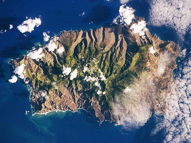
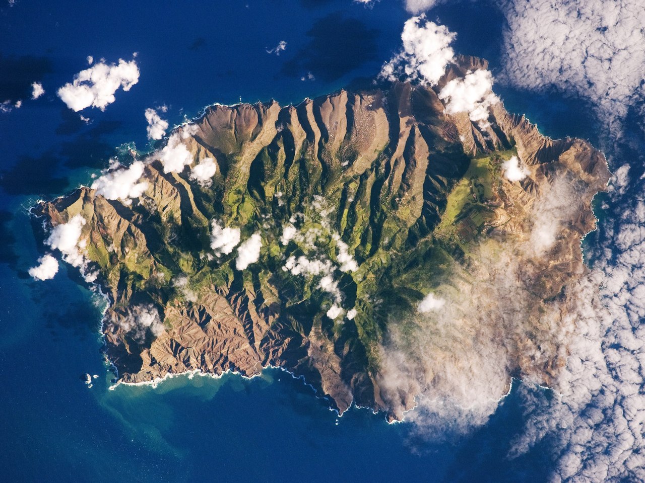
English: This astronaut photograph shows the island’s sharp peaks and deep ravines; the rugged topography results from erosion of the volcanic rocks that make up the island. The change in elevation from the coast to the interior creates a climate gradient. The higher, wetter centre is covered with green vegetation, whereas the lower coastal areas are drier and hotter, with little vegetation cover.
Français : Photo de l'île de Sainte Hélène prise par un astronaute de la NASA. On peut voir les pics élevés de l'île et ses ravines profondes. Cette topographie accidentée résulte de l'action de l'érosion sur les roches volcaniques dont l'île est constituée. Le changement d'élévation entre la périphérie et le centre de l'île créé un gradient climatique: le sommet est plus frais et humide, il est couvert de végétation. Les côtes, plus chaudes et sèches, laissent apparaitre la roche nue.
ISS Crew Earth Observations: ISS019-E-14918
Identification
Mission
ISS019 (Expedition 19)
Roll
E
Frame
14918
Country or Geographic Name
ATLANTIC OCEAN I(S).
Features
ST HELENA I., JAMESTOWN, DIANA PK., FOR., RAVINES
Center Point Latitude
-16.0° N
Center Point Longitude
-5.7° E
Camera
Camera Tilt
6°
Camera Focal Length
400 mm
Camera
Nikon D2Xs
Film
4288 x 2848 pixel CMOS sensor, RGBG imager color filter.
Quality
Percentage of Cloud Cover
11-25%
Nadir What is Nadir?
Date
2009-05-07
Time
08:37:05
Nadir Point Latitude
-15.7° N
Nadir Point Longitude
-5.5° E
Nadir to Photo Center Direction
Southwest
Sun Azimuth
62°
Spacecraft Altitude
193 nautical miles (357 km)
Sun Elevation Angle
26°
Orbit Number
3952
Original image caption
Saint Helena Island, located in the South Atlantic Ocean approximately 1,860 kilometers (1,156 miles) west of Africa, was one of the many isolated islands that naturalist Charles Darwin visited during his scientific voyages in the nineteenth century. He visited the island in 1836 aboard the HMS Beagle, recording observations of the plants, animals, and geology that would shape his theory of evolution. This image was acquired by astronauts onboard the International Space Station as part of an ongoing effort (the HMS Beagle Project to document current biodiversity in areas visited by Charles Darwin.
This astronaut photograph shows the island’s sharp peaks and deep ravines; the rugged topography results from erosion of the volcanic rocks that make up the island. The change in elevation from the coast to the interior creates a climate gradient. The higher, wetter center is covered with green vegetation, whereas the lower coastal areas are drier and hotter, with little vegetation cover. Human presence on the island has also caused dramatic changes to the original plants and animals of the island. Only about 10 percent of the forest cover observed by the first explorers now remains in a semi-natural state, concentrated in the interior highlands.
Saint Helena Island is perhaps best known as the final resting place of Napoleon Bonaparte I of France. Bonaparte was exiled to the island following his defeat at the Battle of Waterloo in 1815; he died on the island six years later in 1821. Today, the island is a British Overseas Territory, with access provided thirty times a year by a single ship, the Royal Mail Ship St. Helena.
Tarix
Mənbə
NASA Earth Observatory
Müəllif
This image was taken by the NASA Expedition 19 crew.
Digər versiyalar
Uncropped version with different grading.
Camera location
15° 56′ 59,9″ S, 5° 42′ 00″ W
View this and other nearby images on: OpenStreetMap
-15.949972; -5.700000
This photograph was acquired with a Nikon 2DXs digital camera fitted with a 400 mm lens, and is provided by the ISS Crew Earth Observations experiment and Image Science & Analysis Laboratory, Johnson Space Centre.
Čeština: Tento obrázek byl vybrán jako obrázek týdne na České Wikipedii pro 5. týden roku 2016.
Dansk: Dette billede har været valgt som ugens billede på den Tjekkiske Wikipedia i uge 5, 2016.
English: This image was selected as a picture of the week on the Czech Wikipedia for 5th week, 2016.
Français : Cette image est sélectionnée en tant qu’image de la semaine sur la Wikipédia Tchèque pour la 5e semaine de 2016.
Italiano : Questa immagine è stata selezionata come Immagine della settimana su Wikipedia in ceco per la V settimana del 2016.
Magyar: Ezt a képet 2016 5. hetében a hét képének választották a cseh Wikipédián.
Svenska: Denna bild valdes som veckans bild på tjeckiskspråkiga Wikipedia för vecka 5, 2016.
Македонски: Сликава е избрана за слика на неделата на чешката Википедија за V недела од 2016 година.
Русский: Эта иллюстрация была выбрана изображением недели в чешском разделе «Википедии» для недели номер 5 2016 года.
Українська: Ця ілюстрація була вибрана зображенням тижня в чеському розділі «Вікіпедії» для тижня номер 5, 2016 року.
العربية : اُختيرت هذه الصُّورة لتكون صُورة الأسبوع في ويكيبيديا التشيكية في الأسبوع 5 في سنة 2016.
Lisenziya
Public domainPublic domainfalsefalse
Annotations
InfoField
This image is annotated: View the annotations at Commons
828
162
72
137
1440
1080
Jamestown
1033
110
92
52
1440
1080
Sugarloaf Point
165
816
74
70
1440
1080
Speary Islands
743
558
81
94
1440
1080
Diana’s Peak
724
922
59
45
1440
1080
The Buoys
1227
923
65
58
1440
1080
George Island
1341
362
58
70
1440
1080
Barn Point
1198
310
157
106
1440
1080
The Barn
284
328
29
36
1440
1080
Egg Island
54
456
32
34
1440
1080
South West Point
182
633
63
74
1440
1080
Manati Bay
237
853
38
34
1440
1080
Castle Rock Point
565
812
38
34
1440
1080
Sandy Bay
607
835
36
31
1440
1080
Sandy Bay Island
776
906
83
59
1440
1080
Powell Bay
1316
484
36
45
1440
1080
Black Point
655
738
56
63
1440
1080
White Hill
780
702
61
128
1440
1080
Long Ground Ridge
1334
609
38
34
1440
1080
Bay Point
1350
696
27
29
1440
1080
Saddle Point
1134
848
81
63
1440
1080
Stone Top Bay
1293
528
88
70
1440
1080
Prosperous Bay
Captions
Bu astronavt fotoşəkili adanın kəskin zirvələrini və adanı təşkil edən vulkanik süxurların aşınmasından yaranan dərin möhkəm topoqrafiyanı göstərir. Yüksəkliyin sahildən içəriyə doğru dəyişməsi iqlim gradiyenti yaradır.
Items portrayed in this file
təsvir edir
Müqəddəs Yelena adası
Commons quality assessment ingilis
Wikimedia Commons valued image ingilis
başlama tarixi: 10 avqust 2009
yaranma tarixi
7 may 2009
coordinates of the point of view ingilis
15°56'59.899"S, 5°42'0.000"W
captured with ingilis
Nikon D2Xs ingilis
exposure time ingilis
0,001 saniyə
f-number ingilis
4
focal length ingilis
400 millimetr
ISO speed ingilis
200
anlayışın sinfi
fotoqrafiya
MIME type ingilis
image/jpeg
Faylın tarixçəsi
Faylın əvvəlki versiyasını görmək üçün gün/tarix bölməsindəki tarixlərə klikləyin.
{{Information |Description={{en|1=This astronaut photograph shows the island’s sharp peaks and deep ravines; the rugged topography results from erosion of the volcanic rocks that make up the island. The change in elevation from the coast to the interior
Bu faylda fotoaparat və ya skanerlə əlavə olunmuş məlumatlar var. Əgər fayl sonradan redaktə olunubsa, bəzi parametrlər bu şəkildə göstərilənlərdən fərqli ola bilər.
Kamera istehsalçısı
NIKON CORPORATION
Kamera modeli
NIKON D2Xs
Exposure time
1/1.000 saniyə (0,001)
F nömrəsi
f/4
ISO sürət reytinqi
200
Orijinal tarix və vaxt
08:37, 7 may 2009
Fokus məsafəsi
400 mm
Orientasiya
Normal
Üfüqi xətt
72 dpi
Şaquli xətt
72 dpi
Proqram təminatı
Adobe Photoshop CS4 Macintosh
Faylın dəyişməsi tarixi və vaxtı
13:28, 12 iyun 2009
Ekspozisiya proqramı
Shutter priority
Exif versiyası
2.21
Tarix və vaxt rəqəmləşdirilir
08:37, 7 may 2009
APEX shutter speed
9,965784
Obyektiv gözü
4
APEX exposure bias
0
Maximum land aperture
3 APEX (f/2,83)
Metering mode
Dizaynlı
İşıq mənbəsi
Naməlum
Flaş
Flaş yandırılmadı
İstifadəçi şərhi
SN# 1111 74.3F
DateTime subseconds
74
DateTimeOriginal subseconds
74
DateTimeDigitized subseconds
74
Rəng sahəsi
sRGB
Sensing method
Birkristallı matrisli rəngli sensor
Fayl mənbəsi
Rəqəmsal fotoapparat
Səhnə tipi
Foto-təsvir birbaşa çəkilmişdir
Custom image processing
Normal proses
Exposure mode
Avtomatik ekspozisiya
Ağ balansı
Bəyaz balansın avtomatik tənzimlənməsi
Digital zoom ratio
1
Focal length in 35 mm film
600 mm
Scene capture type
Standart
Səhnə idarəsi
Heç biri
Kontrast
Yumşaq
Doymuşluq
Normal
Kəskinlik
Normal
Subject distance range
Naməlum
Şəkilin eni
1.440 px
Şəkilin hündürlüyü
1.080 px
Kameranın serial nömrəsi
6027237
İstifadə olunmuş obyektiv
400.0 mm f/2.8
Qiymət (5 üzərində)
0
Date metadata was last modified
09:28, 12 iyun 2009
Unique ID of original document
xmp.did:058011740720681197A5E1CFEF516ADA
Fevral 06, 2023
fayl, saint, helena, island, fayl, faylın, tarixçəsi, istifadə, edilən, səhifələr, faylın, qlobal, istifadəsi, metaməlumatlarsınaq, göstərişi, ölçüsü, piksel, digər, ölçülər, piksel, piksel, piksel, piksel, piksel, faylın, orijinalı, 8206, piksel, fayl, həcmi,. Fayl Faylin tarixcesi Istifade edilen sehifeler Faylin qlobal istifadesi MetamelumatlarSinaq gosterisi olcusu 800 600 piksel Diger olculer 320 240 piksel 640 480 piksel 1 024 768 piksel 1 280 960 piksel 1 440 1 080 piksel Faylin orijinali 8206 1 440 1 080 piksel fayl hecmi 634 KB MIME novu image jpeg Bu fayl Vikimedia Commons dadirve diger layihelerde istifade edile biler Faylin tesvir sehifesine get Xulase Valued imageThis image has been assessed under the valued image criteria and is considered the most valued image on Commons within the scope Saint Helena Island You can see its nomination here IzahSaint Helena Island jpg English This astronaut photograph shows the island s sharp peaks and deep ravines the rugged topography results from erosion of the volcanic rocks that make up the island The change in elevation from the coast to the interior creates a climate gradient The higher wetter centre is covered with green vegetation whereas the lower coastal areas are drier and hotter with little vegetation cover Francais Photo de l ile de Sainte Helene prise par un astronaute de la NASA On peut voir les pics eleves de l ile et ses ravines profondes Cette topographie accidentee resulte de l action de l erosion sur les roches volcaniques dont l ile est constituee Le changement d elevation entre la peripherie et le centre de l ile cree un gradient climatique le sommet est plus frais et humide il est couvert de vegetation Les cotes plus chaudes et seches laissent apparaitre la roche nue ISS Crew Earth Observations ISS019 E 14918 IdentificationMission ISS019 Expedition 19 Roll EFrame 14918Country or Geographic Name ATLANTIC OCEAN I S Features ST HELENA I JAMESTOWN DIANA PK FOR RAVINESCenter Point Latitude 16 0 NCenter Point Longitude 5 7 ECameraCamera Tilt 6 Camera Focal Length 400 mmCamera Nikon D2XsFilm 4288 x 2848 pixel CMOS sensor RGBG imager color filter QualityPercentage of Cloud Cover 11 25 Nadir What is Nadir Date 2009 05 07Time 08 37 05Nadir Point Latitude 15 7 NNadir Point Longitude 5 5 ENadir to Photo Center Direction SouthwestSun Azimuth 62 Spacecraft Altitude 193 nautical miles 357 km Sun Elevation Angle 26 Orbit Number 3952Original image captionSaint Helena Island located in the South Atlantic Ocean approximately 1 860 kilometers 1 156 miles west of Africa was one of the many isolated islands that naturalist Charles Darwin visited during his scientific voyages in the nineteenth century He visited the island in 1836 aboard the HMS Beagle recording observations of the plants animals and geology that would shape his theory of evolution This image was acquired by astronauts onboard the International Space Station as part of an ongoing effort the HMS Beagle Project to document current biodiversity in areas visited by Charles Darwin This astronaut photograph shows the island s sharp peaks and deep ravines the rugged topography results from erosion of the volcanic rocks that make up the island The change in elevation from the coast to the interior creates a climate gradient The higher wetter center is covered with green vegetation whereas the lower coastal areas are drier and hotter with little vegetation cover Human presence on the island has also caused dramatic changes to the original plants and animals of the island Only about 10 percent of the forest cover observed by the first explorers now remains in a semi natural state concentrated in the interior highlands Saint Helena Island is perhaps best known as the final resting place of Napoleon Bonaparte I of France Bonaparte was exiled to the island following his defeat at the Battle of Waterloo in 1815 he died on the island six years later in 1821 Today the island is a British Overseas Territory with access provided thirty times a year by a single ship the Royal Mail Ship St Helena Tarix 7 may 2009Menbe NASA Earth ObservatoryMuellif This image was taken by the NASA Expedition 19 crew Diger versiyalar Uncropped version with different grading Camera location15 56 59 9 S 5 42 00 W View this and other nearby images on OpenStreetMap 15 949972 5 700000This photograph was acquired with a Nikon 2DXs digital camera fitted with a 400 mm lens and is provided by the ISS Crew Earth Observations experiment and Image Science amp Analysis Laboratory Johnson Space Centre Cestina Tento obrazek byl vybran jako obrazek tydne na Ceske Wikipedii pro 5 tyden roku 2016 Dansk Dette billede har vaeret valgt som ugens billede pa den Tjekkiske Wikipedia i uge 5 2016 English This image was selected as a picture of the week on the Czech Wikipedia for 5th week 2016 Francais Cette image est selectionnee en tant qu image de la semaine sur la Wikipedia Tcheque pour la 5e semaine de 2016 Italiano Questa immagine e stata selezionata come Immagine della settimana su Wikipedia in ceco per la V settimana del 2016 Magyar Ezt a kepet 2016 5 heteben a het kepenek valasztottak a cseh Wikipedian Svenska Denna bild valdes som veckans bild pa tjeckisksprakiga Wikipedia for vecka 5 2016 Makedonski Slikava e izbrana za slika na nedelata na cheshkata Vikipediјa za V nedela od 2016 godina Russkij Eta illyustraciya byla vybrana izobrazheniem nedeli v cheshskom razdele Vikipedii dlya nedeli nomer 5 2016 goda Ukrayinska Cya ilyustraciya bula vibrana zobrazhennyam tizhnya v cheskomu rozdili Vikipediyi dlya tizhnya nomer 5 2016 roku العربية ا ختيرت هذه الص ورة لتكون ص ورة الأسبوع في ويكيبيديا التشيكية في الأسبوع 5 في سنة 2016 Lisenziya Public domain Public domain false falseThis file is in the public domain in the United States because it was solely created by NASA NASA copyright policy states that NASA material is not protected by copyright unless noted See Template PD USGov NASA copyright policy page or JPL Image Use Policy Warnings Use of NASA logos insignia and emblems is restricted per U S law 14 CFR 1221 The NASA website hosts a large number of images from the Soviet Russian space agency and other non American space agencies These are not necessarily in the public domain Materials based on Hubble Space Telescope data may be copyrighted if they are not explicitly produced by the STScI 1 See also PD Hubble and Cc Hubble The SOHO ESA amp NASA joint project implies that all materials created by its probe are copyrighted and require permission for commercial non educational use 2 Images featured on the Astronomy Picture of the Day APOD web site may be copyrighted 3 The National Space Science Data Center NSSDC site has been known to host copyrighted content Its photo gallery FAQ states that all of the images in the photo gallery are in the public domain Unless otherwise noted AnnotationsInfoFieldThis image is annotated View the annotations at Commons828 162 72 137 1440 1080 Jamestown 1033 110 92 52 1440 1080 Sugarloaf Point 165 816 74 70 1440 1080 Speary Islands 743 558 81 94 1440 1080 Diana s Peak 724 922 59 45 1440 1080 The Buoys 1227 923 65 58 1440 1080 George Island 1341 362 58 70 1440 1080 Barn Point 1198 310 157 106 1440 1080 The Barn 284 328 29 36 1440 1080 Egg Island 54 456 32 34 1440 1080 South West Point 182 633 63 74 1440 1080 Manati Bay 237 853 38 34 1440 1080 Castle Rock Point 565 812 38 34 1440 1080 Sandy Bay 607 835 36 31 1440 1080 Sandy Bay Island 776 906 83 59 1440 1080 Powell Bay 1316 484 36 45 1440 1080 Black Point 655 738 56 63 1440 1080 White Hill 780 702 61 128 1440 1080 Long Ground Ridge 1334 609 38 34 1440 1080 Bay Point 1350 696 27 29 1440 1080 Saddle Point 1134 848 81 63 1440 1080 Stone Top Bay 1293 528 88 70 1440 1080 Prosperous BayCaptionsazerbaycancaBu astronavt fotosekili adanin keskin zirvelerini ve adani teskil eden vulkanik suxurlarin asinmasindan yaranan derin mohkem topoqrafiyani gosterir Yuksekliyin sahilden iceriye dogru deyismesi iqlim gradiyenti yaradir Items portrayed in this filetesvir edirMuqeddes Yelena adasiCommons quality assessment ingilisWikimedia Commons valued image ingilisbaslama tarixi 10 avqust 2009yaranma tarixi7 may 2009coordinates of the point of view ingilis15 56 59 899 S 5 42 0 000 Wcaptured with ingilisNikon D2Xs ingilisexposure time ingilis0 001 saniyef number ingilis4focal length ingilis400 millimetrISO speed ingilis200anlayisin sinfifotoqrafiyaMIME type ingilisimage jpeg Faylin tarixcesi Faylin evvelki versiyasini gormek ucun gun tarix bolmesindeki tarixlere klikleyin Tarix VaxtKicik sekilOlculerIstifadeciSerh indiki11 28 23 mart 20151 440 1 080 634 KB Julian HerzogReverted to version as of 18 00 19 March 2015 rotation was done then 08 00 20 mart 20151 440 1 080 634 KB SteinsplitterBotBot Image rotated by 180 18 00 19 mart 20151 440 1 080 634 KB SteinsplitterBotBot Image rotated by 180 09 40 15 iyun 20091 440 1 080 622 KB Originalwana Information Description en 1 This astronaut photograph shows the island s sharp peaks and deep ravines the rugged topography results from erosion of the volcanic rocks that make up the island The change in elevation from the coast to the interior Istifade edilen sehifeler Bu sekile olan kecidler Muqeddes Yelena adasi Faylin qlobal istifadesi Bu fayl asagidaki vikilerde istifade olunur als wikipedia org layihesinde istifadesi St Helena Insel ar wikipedia org layihesinde istifadesi جغرافيا سانت هيلينا قائمة مواقع التراث العالمي في المملكة المتحدة arz wikipedia org layihesinde istifadesi سانت هيلينا ast wikipedia org layihesinde istifadesi Islla Santa Lena Santa Lena bar wikipedia org layihesinde istifadesi St Helena Insel be wikipedia org layihesinde istifadesi Vostray Svyatoj Aleny bg wikipedia org layihesinde istifadesi Sveta Elena ostrov bs wikipedia org layihesinde istifadesi Wikipedia Slika sedmice Arhiva 2009 Sablon Slika sedmice 36 2009 Wikipedia Slika sedmice Glasanje Arhiva Prihvaceni prijedlozi Arhiva 4 ca wikipedia org layihesinde istifadesi Santa Helena ceb wikipedia org layihesinde istifadesi Saint Helena Island pulo sa Santaylena co wikipedia org layihesinde istifadesi Sant Elena cs wikipedia org layihesinde istifadesi Wikipedie Obrazek tydne 2016 Wikipedie Obrazek tydne 2016 05 da wikipedia org layihesinde istifadesi Bruger Palnatoke Autolister Geografi Oer i Storbritannien de wikipedia org layihesinde istifadesi St Helena Insel Welterbe im Vereinigten Konigreich Diana s Peak en wikipedia org layihesinde istifadesi Saint Helena Geography of Saint Helena List of World Heritage Sites in the United Kingdom List of mountains and hills of Saint Helena Ascension and Tristan da Cunha en wikiversity org layihesinde istifadesi Orbital platforms eo wikipedia org layihesinde istifadesi Sankta Heleno es wikipedia org layihesinde istifadesi Isla Santa Elena Santa Elena Ascension y Tristan de Acuna Geografia de Santa Elena es wiktionary org layihesinde istifadesi Santa Elena frp wikipedia org layihesinde istifadesi Vouiquipedia Emage du jorn fevrier 2021 Vouiquipedia Emage du jorn 8 de fevrier 2021 fr wikipedia org layihesinde istifadesi Liste du patrimoine mondial au Royaume Uni Wikipedia Image du jour 17 fevrier 2016 Wikipedia Image du jour fevrier 2016 Wikipedia Le Bistro 20 fevrier 2016 Wikipedia Wikimag 2021 19 Rapport de trafic ga wikipedia org layihesinde istifadesi San Heilin he wikipedia org layihesinde istifadesi סנט הלנה סנט הלנה אסנשן וטריסטן דה קונה hy wikipedia org layihesinde istifadesi Սուրբ Հեղինեի կղզի Միացյալ Թագավորությունում ՅՈՒՆԵՍԿՕ ի Համաշխարհային ժառանգության ցանկ ig wikipedia org layihesinde istifadesi Saint Helena it wikipedia org layihesinde istifadesi Patrimoni dell umanita del Regno Unito it wikivoyage org layihesinde istifadesi Sant Elena Ascensione e Tristan da Cunha kk wikipedia org layihesinde istifadesi Әulie Elena araly Ұlybritaniyadagy YuNESKO Әlemdik mura nysandar tizimi ko wikipedia org layihesinde istifadesi 세인트헬레나 lt wikipedia org layihesinde istifadesi Sv Elenos sala Bu faylin qlobal istifadesine baxin Metamelumatlar Bu faylda fotoaparat ve ya skanerle elave olunmus melumatlar var Eger fayl sonradan redakte olunubsa bezi parametrler bu sekilde gosterilenlerden ferqli ola biler Kamera istehsalcisiNIKON CORPORATIONKamera modeliNIKON D2XsExposure time1 1 000 saniye 0 001 F nomresif 4ISO suret reytinqi200Orijinal tarix ve vaxt08 37 7 may 2009Fokus mesafesi400 mmOrientasiyaNormalUfuqi xett72 dpiSaquli xett72 dpiProqram teminatiAdobe Photoshop CS4 MacintoshFaylin deyismesi tarixi ve vaxti13 28 12 iyun 2009Ekspozisiya proqramiShutter priorityExif versiyasi2 21Tarix ve vaxt reqemlesdirilir08 37 7 may 2009APEX shutter speed9 965784Obyektiv gozu4APEX exposure bias0Maximum land aperture3 APEX f 2 83 Metering modeDizaynliIsiq menbesiNamelumFlasFlas yandirilmadiIstifadeci serhiSN 1111 74 3FDateTime subseconds74DateTimeOriginal subseconds74DateTimeDigitized subseconds74Reng sahesisRGBSensing methodBirkristalli matrisli rengli sensorFayl menbesiReqemsal fotoapparatSehne tipiFoto tesvir birbasa cekilmisdirCustom image processingNormal prosesExposure modeAvtomatik ekspozisiyaAg balansiBeyaz balansin avtomatik tenzimlenmesiDigital zoom ratio1Focal length in 35 mm film600 mmScene capture typeStandartSehne idaresiHec biriKontrastYumsaqDoymusluqNormalKeskinlikNormalSubject distance rangeNamelumSekilin eni1 440 pxSekilin hundurluyu1 080 pxKameranin serial nomresi6027237Istifade olunmus obyektiv400 0 mm f 2 8Qiymet 5 uzerinde 0Date metadata was last modified09 28 12 iyun 2009Unique ID of original documentxmp did 058011740720681197A5E1CFEF516ADA Menbe https az wikipedia org wiki Fayl Saint Helena Island jpg, wikipedia, oxu, kitab, kitabxana, axtar, tap, hersey,
ne axtarsan burda
, en yaxsi meqale sayti, meqaleler, kitablar, oyrenmek, wiki, bilgi, tarix, seks, porno, indir, yukle, sex, azeri sex, azeri, seks yukle, sex yukle, izle, seks izle, porno izle, mobil seks, telefon ucun, chat, azeri chat, tanisliq, tanishliq, azeri tanishliq, sayt, medeni, medeni saytlar, chatlar, mekan, tanisliq mekani, mekanlari, yüklə, pulsuz, pulsuz yüklə, mp3, video, mp4, 3gp, jpg, jpeg, gif, png, şəkil, muisiqi, mahnı, kino, film, kitab, oyun, oyunlar.