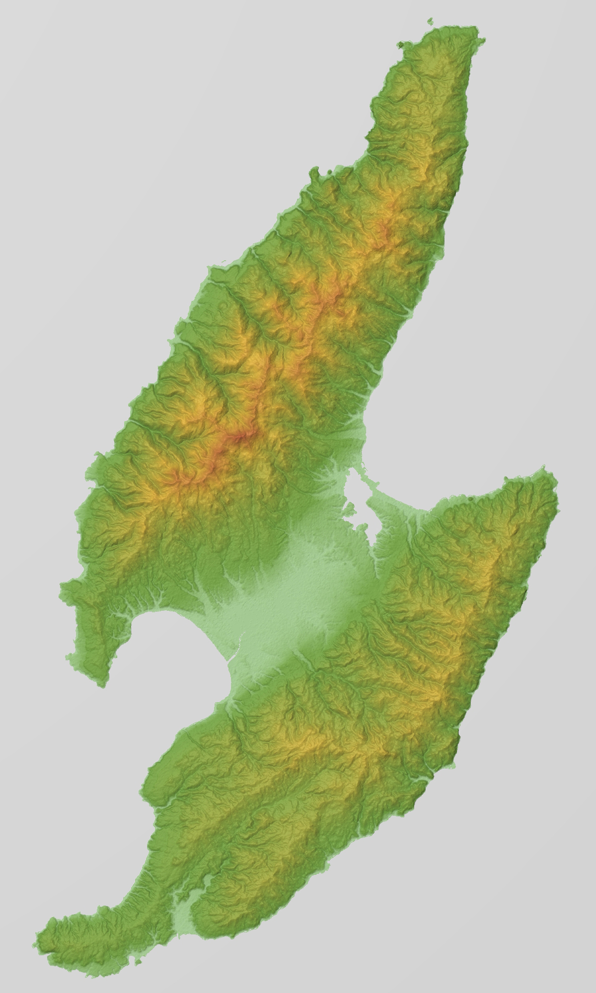
{{Information |Description= {{en|Relief map of Sadogashima Island (佐渡島), Niigata Prefecture, Japan. From "SRTM-1 (30m Mesh) Ver.3 2014".}}...
Fayl keçidləri
Bu faylı istifadə edən səhifə yoxdur.
Faylın qlobal istifadəsi
Bu fayl aşağıdakı vikilərdə istifadə olunur:
User:S1933373TL/佐渡岛
両津湾
真野湾
国中平野
大佐渡山地
Metaməlumatlar
Bu faylda fotoaparat və ya skanerlə əlavə olunmuş məlumatlar var. Əgər fayl sonradan redaktə olunubsa, bəzi parametrlər bu şəkildə göstərilənlərdən fərqli ola bilər.
Rəng sahəsi
Fotoşəkildə rəng seçimi edilməmişdir.
May 07, 2023
fayl, sadogashima, island, relief, srtm, fayl, faylın, tarixçəsi, fayl, keçidləri, faylın, qlobal, istifadəsi, metaməlumatlarsınaq, göstərişi, ölçüsü, piksel, digər, ölçülər, piksel, piksel, piksel, piksel, faylın, orijinalı, 8206, piksel, fayl, həcmi, mime, n. Fayl Faylin tarixcesi Fayl kecidleri Faylin qlobal istifadesi MetamelumatlarSinaq gosterisi olcusu 360 600 piksel Diger olculer 144 240 piksel 288 480 piksel 461 768 piksel 1 200 2 000 piksel Faylin orijinali 8206 1 200 2 000 piksel fayl hecmi 885 KB MIME novu image jpeg Bu fayl Vikimedia Commons dadirve diger layihelerde istifade edile biler Faylin tesvir sehifesine get Xulase IzahSadogashima Island Relief Map SRTM 1 jpg English Sadogashima Sado Island in Niigata Prefecture Japan 日本語 新潟県の佐渡島 Tarix 29 fevral 2016 Menbe Topographic data NASA s SRTM 1 30m Mesh ver 3 2014 Rendering software KASHMIR 3D Muellif Batholith Object location38 nbsp 02 nbsp 00 nbsp N 138 nbsp 23 nbsp 00 nbsp E nbsp View this and other nearby images on OpenStreetMap38 033333 138 383333 Lisenziya Public domain Public domain false false Men bu eserin muellif huquqlarinin sahibi kimi eseri ictimai mulkiyyete verirem Bu icaze butun dunyada quvvededir In some countries this may not be legally possible if so Bunun qanunla mumkun olmadigi hallarda Istenilen sexse istenilen meqsed ucun qanunlar terefinden qadagan edilmeyince hec bir sert qoymadan bu isden istifade haqqini bagislayiram Public domain Public domain false false This image uses high resolution digital topography data from NASA s Shuttle Radar Topography Mission SRTM at JPL Caltech 1 It is in the public domain in the United States English nbsp Bahasa Indonesia nbsp makedonski nbsp polski nbsp portugues nbsp 中文 nbsp 中文 简体 nbsp CaptionsazerbaycancaAdd a one line explanation of what this file representsItems portrayed in this filetesvir edircopyright status nbsp ingiliscopyrighted dedicated to the public domain by copyright holder nbsp ingiliscopyrighted nbsp ingilislisenziyareleased into the public domain by the copyright holder nbsp ingilisyaranma tarixi29 fevral 2016coordinates of depicted place nbsp ingilis38 1 59 999 N 138 22 59 999 E Faylin tarixcesi Faylin evvelki versiyasini gormek ucun gun tarix bolmesindeki tarixlere klikleyin Tarix VaxtKicik sekilOlculerIstifadeciSerh indiki07 22 29 fevral 20161 200 2 000 885 KB Batholith Information Description en Relief map of Sadogashima Island 佐渡島 Niigata Prefecture Japan From SRTM 1 30m Mesh Ver 3 2014 Fayl kecidleri Bu fayli istifade eden sehife yoxdur Faylin qlobal istifadesi Bu fayl asagidaki vikilerde istifade olunur en wikipedia org layihesinde istifadesi Sado Island User S1933373TL 佐渡岛 fi wikipedia org layihesinde istifadesi Sado saari id wikipedia org layihesinde istifadesi Pulau Sado ja wikipedia org layihesinde istifadesi 佐渡島 両津湾 真野湾 国中平野 大佐渡山地 no wikipedia org layihesinde istifadesi Sado oy sv wikipedia org layihesinde istifadesi Sado tr wikipedia org layihesinde istifadesi Sado Adasi www wikidata org layihesinde istifadesi Q998623 zh wikipedia org layihesinde istifadesi 佐渡岛Metamelumatlar Bu faylda fotoaparat ve ya skanerle elave olunmus melumatlar var Eger fayl sonradan redakte olunubsa bezi parametrler bu sekilde gosterilenlerden ferqli ola biler Reng sahesiFotosekilde reng secimi edilmemisdir Menbe https az wikipedia org wiki Fayl Sadogashima Island Relief Map SRTM 1 jpg, wikipedia, oxu, kitab, kitabxana, axtar, tap, hersey,
ne axtarsan burda
, en yaxsi meqale sayti, meqaleler, kitablar, oyrenmek, wiki, bilgi, tarix, seks, porno, indir, yukle, sex, azeri sex, azeri, seks yukle, sex yukle, izle, seks izle, porno izle, mobil seks, telefon ucun, chat, azeri chat, tanisliq, tanishliq, azeri tanishliq, sayt, medeni, medeni saytlar, chatlar, mekan, tanisliq mekani, mekanlari, yüklə, pulsuz, pulsuz yüklə, mp3, video, mp4, 3gp, jpg, jpeg, gif, png, şəkil, muisiqi, mahnı, kino, film, kitab, oyun, oyunlar.