Bu fayl "Vikimedia Commons"dadır və digər layihələrdə istifadə edilə bilər.
Faylın təsvir səhifəsinə get
This locator map image could be re-created using vector graphics as an SVG file. This has several advantages; see Commons:Media for cleanup for more information. If an SVG form of this image is available, please upload it and afterwards replace this template with {{vector version available|new image name}}. It is recommended to name the SVG file "RegionsHungary.svg" – then the template Vector version available (or Vva) does not need the new image name parameter.
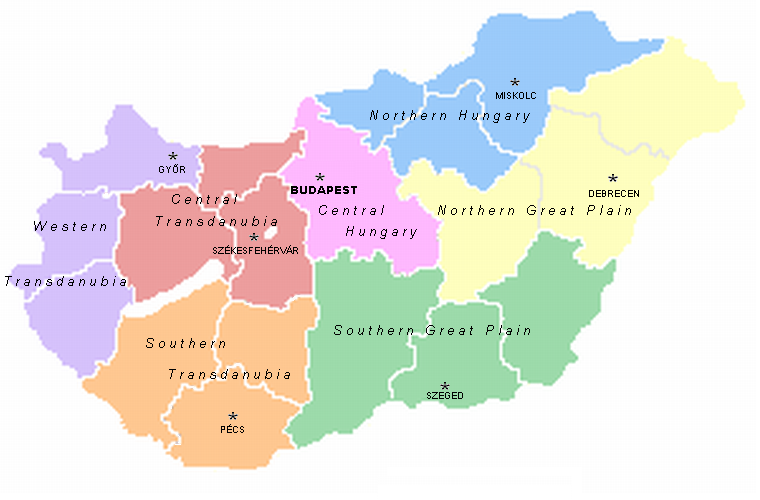
A map of the seven statistical regions of Hungary with their regional centres. It was made by User:Alensha by modifying the maps of the counties that also can be found here. If it means that the copyright is mine then I release it to public domain but if it belongs to the guy who made the pic Zalamegye.png from which it was modified, then it is GNU FDL.
Bu sənədi GNU Azad Sənədləşdirmə Lisenziyası, Versiya 1.2 və ya Azad Proqram Fondu tərəfindən nəşr olunan hər hansı sonrakı versiya şərtlərinə əsasən dəyişməz bölmələr, ön qapaq mətnləri və arxa qapaq mətnləri olmadan köçürmək, yayımlamaq və / və ya dəyişdirmək üçün icazə verilir; Lisenziyanın bir nüsxəsi GNU Azad Sənədləşdirmə Lisenziyası adlı hissəyə daxil edilmişdir.http://www.gnu.org/copyleft/fdl.htmlGFDLGNU Free Documentation Licensetruetrue
Bu fayl Creative Commons Attribution-Share Alike 3.0 Sinqapur lisenziyası altında yayımlanır.
Azadsınız:
paylaşmaq – əsəri köçürmək, paylamaq və ötürmək üçün
remiks etmək – əsəri adaptasiya etmək
Aşağıdakı şərtlərə riayət etməklə:
istinad – Müvafiq kredit verməlisiniz, lisenziyaya bir keçid verməlisiniz və dəyişikliklərin olub olmadığını bildirməlisiniz. Bunu hər hansı bir ağlabatan şəkildə edə bilərsiniz, ancaq lisenziyalaşdırıcının sizi və ya istifadənizi təsdiqləməsini təklif edən bir şəkildə deyil.
bənzər paylaşma – Əsəri remix edirsinizsə, dəyişdirirsinizsə və ya üzərində iş aparırsınızsa, öz töhfələrinizi orijinalda olduğu kimi eyni və ya uyğun lisenziya altında yayımlamalısınız.
This licensing tag was added to this file as part of the GFDL licensing update.http://creativecommons.org/licenses/by-sa/3.0/CC-BY-SA-3.0Creative Commons Attribution-Share Alike 3.0truetrue
Captions
Add a one-line explanation of what this file represents
Items portrayed in this file
təsvir edir
copyright status ingilis
copyrighted ingilis
lisenziya
Creative Commons Attribution-ShareAlike 3.0 Unported ingilis
GNU Free Documentation License, version 1.2 or later ingilis
Faylın tarixçəsi
Faylın əvvəlki versiyasını görmək üçün gün/tarix bölməsindəki tarixlərə klikləyin.
A map of the seven statistical regions of Hungary with their regional centres. It was made by User:Alensha by modifying the maps of the counties that also can be found here. If it means that the copyright is mine then I release it to public domain but
fayl, regionshungary, fayl, faylın, tarixçəsi, istifadə, edilən, səhifələr, faylın, qlobal, istifadəsidaha, yüksək, versiyası, yoxdur, regionshungary, 8206, piksel, fayl, həcmi, mime, növü, image, fayl, vikimedia, commons, dadırvə, digər, layihələrdə, istifadə. Fayl Faylin tarixcesi Istifade edilen sehifeler Faylin qlobal istifadesiDaha yuksek versiyasi yoxdur RegionsHungary png 8206 760 500 piksel fayl hecmi 122 KB MIME novu image png Bu fayl Vikimedia Commons dadirve diger layihelerde istifade edile biler Faylin tesvir sehifesine get This locator map image could be re created using vector graphics as an SVG file This has several advantages see Commons Media for cleanup for more information If an SVG form of this image is available please upload it and afterwards replace this template with vector version available i new image name i It is recommended to name the SVG file RegionsHungary svg then the template Vector version available or Vva does not need the new image name parameter A map of the seven statistical regions of Hungary with their regional centres It was made by User Alensha by modifying the maps of the counties that also can be found here If it means that the copyright is mine then I release it to public domain but if it belongs to the guy who made the pic Zalamegye png from which it was modified then it is GNU FDL Bu senedi GNU Azad Senedlesdirme Lisenziyasi Versiya 1 2 ve ya Azad Proqram Fondu terefinden nesr olunan her hansi sonraki versiya sertlerine esasen deyismez bolmeler on qapaq metnleri ve arxa qapaq metnleri olmadan kocurmek yayimlamaq ve ve ya deyisdirmek ucun icaze verilir Lisenziyanin bir nusxesi GNU Azad Senedlesdirme Lisenziyasi adli hisseye daxil edilmisdir http www gnu org copyleft fdl html GFDL GNU Free Documentation License true trueBu fayl Creative Commons Attribution Share Alike 3 0 Sinqapur lisenziyasi altinda yayimlanir Azadsiniz paylasmaq eseri kocurmek paylamaq ve oturmek ucun remiks etmek eseri adaptasiya etmek Asagidaki sertlere riayet etmekle istinad Muvafiq kredit vermelisiniz lisenziyaya bir kecid vermelisiniz ve deyisikliklerin olub olmadigini bildirmelisiniz Bunu her hansi bir aglabatan sekilde ede bilersiniz ancaq lisenziyalasdiricinin sizi ve ya istifadenizi tesdiqlemesini teklif eden bir sekilde deyil benzer paylasma Eseri remix edirsinizse deyisdirirsinizse ve ya uzerinde is aparirsinizsa oz tohfelerinizi orijinalda oldugu kimi eyni ve ya uygun lisenziya altinda yayimlamalisiniz This licensing tag was added to this file as part of the GFDL licensing update http creativecommons org licenses by sa 3 0 CC BY SA 3 0 Creative Commons Attribution Share Alike 3 0 true trueCaptionsazerbaycancaAdd a one line explanation of what this file representsItems portrayed in this filetesvir edircopyright status ingiliscopyrighted ingilislisenziyaCreative Commons Attribution ShareAlike 3 0 Unported ingilisGNU Free Documentation License version 1 2 or later ingilis Faylin tarixcesi Faylin evvelki versiyasini gormek ucun gun tarix bolmesindeki tarixlere klikleyin Tarix VaxtKicik sekilOlculerIstifadeciSerh indiki13 09 2 mart 2007760 500 122 KB Tene commonswikiOptimised 5 14 07 21 may 2005760 500 164 KB AlenshaA map of the seven statistical regions of Hungary with their regional centres It was made by User Alensha by modifying the maps of the counties that also can be found here If it means that the copyright is mine then I release it to public domain but Istifade edilen sehifeler Bu sekile olan kecidler Cenubi Zadunay bolgesi Cenubi Alfold Macaristanin inzibati bolgusu Macaristanin regionlari Transdunay Simali Alfold Simali Macaristan Faylin qlobal istifadesi Bu fayl asagidaki vikilerde istifade olunur ast wikipedia org layihesinde istifadesi Xeografia d Hungria Rexones d Hungria be wikipedia org layihesinde istifadesi Paydnyova Zadunajski kraj Paynochnaya Vengryya Regiyony Vengryi Zahodne Zadunajski kraj Centralna Zadunajski kraj ca wikipedia org layihesinde istifadesi Geografia d Hongria da wikipedia org layihesinde istifadesi Ungarn de wikipedia org layihesinde istifadesi Nordungarn el wikipedia org layihesinde istifadesi Yperdoynabia en wikipedia org layihesinde istifadesi Hungary List of regions of Hungary Transdanubia Template Hungary regions imagemap 550 User Mtlelas sandbox eo wikipedia org layihesinde istifadesi Norda Hungario Norda Ebenaĵo Suda Ebenaĵo Meza Transdanubio Okcidenta Transdanubio Meza Hungario es wikipedia org layihesinde istifadesi Geografia de Hungria Organizacion territorial de Hungria Transdanubia fa wikipedia org layihesinde istifadesi مجارستان جغرافیای مجارستان الگو Hungary regions imagemap 550 فهرست منطقه های مجارستان پیش نویس مجارستان fr wikipedia org layihesinde istifadesi Region statistique et de planification gl wikipedia org layihesinde istifadesi Hungria Transdanubia occidental Transdanubia meridional Gran Chaira do Sur Gran Chaira do Norte Hungria do norte Transdanubia central Hungria central Rexions de Hungria he wikipedia org layihesinde istifadesi טרנסדנוביה חבלי הונגריה hr wikipedia org layihesinde istifadesi Mađarske regije Predlozak Karta mađarskih regija kk wikipedia org layihesinde istifadesi Mazharstannyn әkimshilik bolinisi lt wikipedia org layihesinde istifadesi Vengrijos regionai nl wikipedia org layihesinde istifadesi Gebruiker Abnormaal Zandbak Bestuurlijke indeling van Hongarije Transdanubie Gebruiker Abnormaal Kladblok Bu faylin qlobal istifadesine baxin Menbe https az wikipedia org wiki Fayl RegionsHungary png, wikipedia, oxu, kitab, kitabxana, axtar, tap, hersey,
ne axtarsan burda
, en yaxsi meqale sayti, meqaleler, kitablar, oyrenmek, wiki, bilgi, tarix, seks, porno, indir, yukle, sex, azeri sex, azeri, seks yukle, sex yukle, izle, seks izle, porno izle, mobil seks, telefon ucun, chat, azeri chat, tanisliq, tanishliq, azeri tanishliq, sayt, medeni, medeni saytlar, chatlar, mekan, tanisliq mekani, mekanlari, yüklə, pulsuz, pulsuz yüklə, mp3, video, mp4, 3gp, jpg, jpeg, gif, png, şəkil, muisiqi, mahnı, kino, film, kitab, oyun, oyunlar.