Bu fayl "Vikimedia Commons"dadır və digər layihələrdə istifadə edilə bilər.
Faylın təsvir səhifəsinə get
Bilindik köyü
Xülasə
İzahPost Roman Balkans.jpg
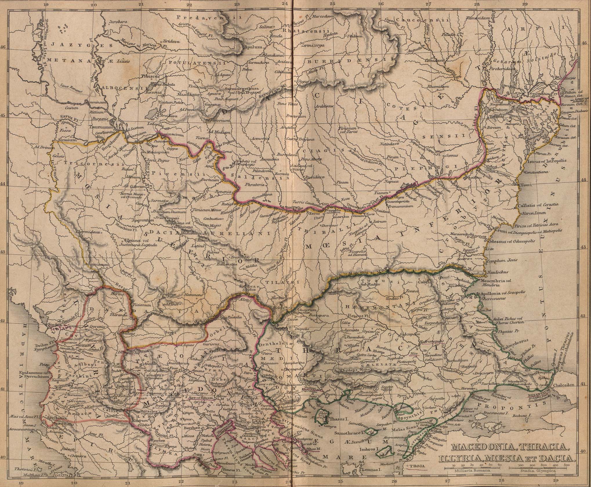
Macedonia, Thracia, Illyria, Moesia, Dacia,(Map X),"Comment on Map from author; Map X., & c. - Although most portions of this map are well represented, still we have a deficiency in the classical portion, as it has not been yet sufficiently examined by those who are capable of deciding and systematizing the comparative geography."
This map includes even 2nd century AD (i.e. Adrianopolis) cities and perhaps even later ones.
This map is a Post-Roman conquest map, the atlas was called "classical" and included many types of maps.
Locations of many cities, tribes or other features are according to 1849 scholarship and not up to date. For example, many cities shown have not been identified yet and Findlay made arbirtrary conclusions. A great omission is that Lake Prespas are missing.
Tarix
Mənbə
A classical atlas, to illustrate ancient geography: comprised in twenty-five maps, showing the various divisions of the world as known to the ancients : composed from the most authentic sources with an index of the ancient and modern names,Alexander G. Findlay,Publisher;Harper,1849
Müəllif
Alexander G. Findlay
İcazə (Faylın təkrar istifadəsi)
Public domainPublic domainfalsefalse
https://creativecommons.org/publicdomain/mark/1.0/PDMCreative Commons Public Domain Mark 1.0falsefalse
Digər versiyalar
Captions
Add a one-line explanation of what this file represents
Alexander G. Findlay Klasik Atlas Antik Coğrafyayı Resmedecek, New York, 1849
Items portrayed in this file
təsvir edir
yaranma tarixi
1849
Faylın tarixçəsi
Faylın əvvəlki versiyasını görmək üçün gün/tarix bölməsindəki tarixlərə klikləyin.
Reverted to version as of 01:28, 27 March 2005 - restored original version which has more historical value. please upload your whitened version as a new separate file, not over this one, thank you
Classical Balkans: from ''Map from "rothers Publishers, New York, 1849A Classical Atlas to Illustrate Ancient Geography,'' Alexander G. Findlay, Harper and B ros. NY 1849 {{PD-art}} category:History of the Balkans
Bu faylda fotoaparat və ya skanerlə əlavə olunmuş məlumatlar var. Əgər fayl sonradan redaktə olunubsa, bəzi parametrlər bu şəkildə göstərilənlərdən fərqli ola bilər.
JPEG şəkil şərhi
File written by Adobe Photoshop¨ 4.0
Aprel 09, 2023
fayl, post, roman, balkans, fayl, faylın, tarixçəsi, fayl, keçidləri, faylın, qlobal, istifadəsi, metaməlumatlarsınaq, göstərişi, ölçüsü, piksel, digər, ölçülər, piksel, piksel, piksel, piksel, piksel, faylın, orijinalı, 8206, piksel, fayl, həcmi, mime, növü, . Fayl Faylin tarixcesi Fayl kecidleri Faylin qlobal istifadesi MetamelumatlarSinaq gosterisi olcusu 729 600 piksel Diger olculer 292 240 piksel 583 480 piksel 933 768 piksel 1 245 1 024 piksel 2 038 1 677 piksel Faylin orijinali 8206 2 038 1 677 piksel fayl hecmi 721 KB MIME novu image jpeg Bu fayl Vikimedia Commons dadirve diger layihelerde istifade edile biler Faylin tesvir sehifesine get Bilindik koyu Xulase IzahPost Roman Balkans jpg Macedonia Thracia Illyria Moesia Dacia Map X Comment on Map from author Map X amp c Although most portions of this map are well represented still we have a deficiency in the classical portion as it has not been yet sufficiently examined by those who are capable of deciding and systematizing the comparative geography This map includes even 2nd century AD i e Adrianopolis cities and perhaps even later ones This map is a Post Roman conquest map the atlas was called classical and included many types of maps Locations of many cities tribes or other features are according to 1849 scholarship and not up to date For example many cities shown have not been identified yet and Findlay made arbirtrary conclusions A great omission is that Lake Prespas are missing Tarix 1849 Menbe A classical atlas to illustrate ancient geography comprised in twenty five maps showing the various divisions of the world as known to the ancients nbsp composed from the most authentic sources with an index of the ancient and modern names Alexander G Findlay Publisher Harper 1849 Muellif Alexander G Findlay Icaze Faylin tekrar istifadesi Public domain Public domain false false This work is in the public domain in its country of origin and other countries and areas where the copyright term is the author s life plus 70 years or fewer You must also include a United States public domain tag to indicate why this work is in the public domain in the United States nbsp Note that a few countries have copyright terms longer than 70 years Mexico has 100 years Jamaica has 95 years Colombia has 80 years and Guatemala and Samoa have 75 years This image may not be in the public domain in these countries which moreover do not implement the rule of the shorter term Cote d Ivoire has a general copyright term of 99 years and Honduras has 75 years but they do implement the rule of the shorter term Copyright may extend on works created by French who died for France in World War II more information Russians who served in the Eastern Front of World War II known as the Great Patriotic War in Russia and posthumously rehabilitated victims of Soviet repressions more information This file has been identified as being free of known restrictions under copyright law including all related and neighboring rights https creativecommons org publicdomain mark 1 0 PDM Creative Commons Public Domain Mark 1 0 false false Diger versiyalarCaptionsazerbaycancaAdd a one line explanation of what this file representsturkAlexander G Findlay Klasik Atlas Antik Cografyayi Resmedecek New York 1849Items portrayed in this filetesvir ediryaranma tarixi1849 Faylin tarixcesi Faylin evvelki versiyasini gormek ucun gun tarix bolmesindeki tarixlere klikleyin Tarix VaxtKicik sekilOlculerIstifadeciSerh indiki18 49 28 yanvar 20102 038 1 677 721 KB PANONIANReverted to version as of 01 28 27 March 2005 restored original version which has more historical value please upload your whitened version as a new separate file not over this one thank you 10 02 17 may 20092 038 1 677 1 1 MB Alex Dwhitened 01 28 27 mart 20052 038 1 677 721 KB Karmosin commonswikiClassical Balkans from 039 039 Map from rothers Publishers New York 1849A Classical Atlas to Illustrate Ancient Geography 039 039 Alexander G Findlay Harper and B ros NY 1849 PD art category History of the Balkans Fayl kecidleri Bu sekile olan kecidler Frakiya Faylin qlobal istifadesi Bu fayl asagidaki vikilerde istifade olunur ar wikipedia org layihesinde istifadesi تاريخ كوسوفو arz wikipedia org layihesinde istifadesi ريسكوبوريس الاول ملك azb wikipedia org layihesinde istifadesi تراکیا ba wikipedia org layihesinde istifadesi Frakiya be tarask wikipedia org layihesinde istifadesi Trakiya be wikipedia org layihesinde istifadesi Frakiya Ushodnyaya Frakiya Myoziya bg wikipedia org layihesinde istifadesi Devol grad Istoriya na Kosovo ca wikipedia org layihesinde istifadesi Historia de Kosovo cs wikipedia org layihesinde istifadesi Portal Balkan Portal Balkan uvod en wikipedia org layihesinde istifadesi Talk Timișoara Talk Thrace User Matia gr Evidence Talk Demographic history of Macedonia Archive 4 Talk North Macedonia Archive 13 Talk Spartacus Archive 1 eo wikipedia org layihesinde istifadesi Trakio es wikipedia org layihesinde istifadesi Historia de Kosovo Tracia Oriental gl wikipedia org layihesinde istifadesi Dacia he wikipedia org layihesinde istifadesi דאקיה hr wikipedia org layihesinde istifadesi Povijest Albanije hy wikipedia org layihesinde istifadesi Արևելյան Թրակիա it wikipedia org layihesinde istifadesi Macedonia regione storica ja wikipedia org layihesinde istifadesi 利用者 会話 Vacsora FArchive マルクス テレンティウス ウァッロ ルクッルス mk wikipedia org layihesinde istifadesi Meziјa nl wikipedia org layihesinde istifadesi Portaal Zuidoost Europa Portaal Thracie Portaal Bulgarije Portaal Bulgarije verwante portalen pt wikipedia org layihesinde istifadesi Tracia Dacia ro wikipedia org layihesinde istifadesi Istoria provinciei Kosovo ru wikipedia org layihesinde istifadesi Frakiya Drevnyaya Makedoniya Dakiya Myoziya Armiya Drevnej Makedonii Vostochnaya Frakiya Myozy Mark Terencij Varron Lukull Drevnyaya Frakiya Krobizy Kotis II Rejzdos Kotis III Bu faylin qlobal istifadesine baxin Metamelumatlar Bu faylda fotoaparat ve ya skanerle elave olunmus melumatlar var Eger fayl sonradan redakte olunubsa bezi parametrler bu sekilde gosterilenlerden ferqli ola biler JPEG sekil serhiFile written by Adobe Photoshop 4 0 Menbe https az wikipedia org wiki Fayl Post Roman Balkans jpg, wikipedia, oxu, kitab, kitabxana, axtar, tap, hersey,
ne axtarsan burda
, en yaxsi meqale sayti, meqaleler, kitablar, oyrenmek, wiki, bilgi, tarix, seks, porno, indir, yukle, sex, azeri sex, azeri, seks yukle, sex yukle, izle, seks izle, porno izle, mobil seks, telefon ucun, chat, azeri chat, tanisliq, tanishliq, azeri tanishliq, sayt, medeni, medeni saytlar, chatlar, mekan, tanisliq mekani, mekanlari, yüklə, pulsuz, pulsuz yüklə, mp3, video, mp4, 3gp, jpg, jpeg, gif, png, şəkil, muisiqi, mahnı, kino, film, kitab, oyun, oyunlar.