View this and other nearby images on: OpenStreetMap
19.409500; -99.130700
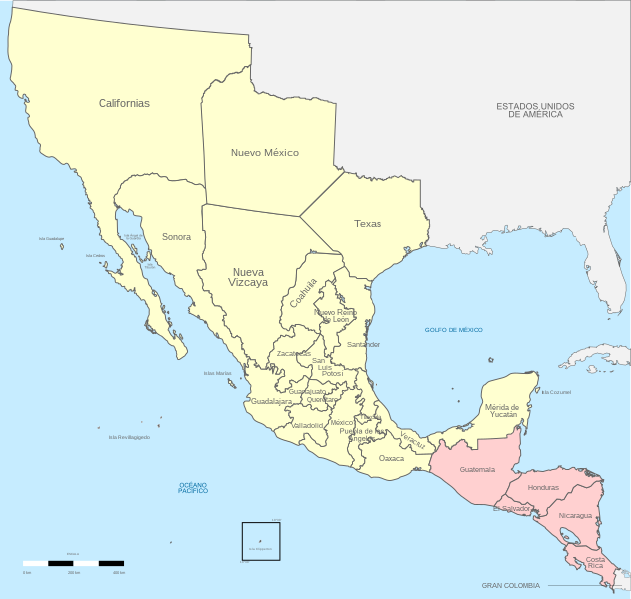
Territorio de mexico, 1821.
Lisenziya
I, the copyright holder of this work, hereby publish it under the following licenses:
Bu fayl Creative Commons Attribution-Share Alike 3.0 Sinqapur lisenziyası altında yayımlanır.
Azadsınız:
paylaşmaq – əsəri köçürmək, paylamaq və ötürmək üçün
remiks etmək – əsəri adaptasiya etmək
Aşağıdakı şərtlərə riayət etməklə:
istinad – Müvafiq kredit verməlisiniz, lisenziyaya bir keçid verməlisiniz və dəyişikliklərin olub olmadığını bildirməlisiniz. Bunu hər hansı bir ağlabatan şəkildə edə bilərsiniz, ancaq lisenziyalaşdırıcının sizi və ya istifadənizi təsdiqləməsini təklif edən bir şəkildə deyil.
bənzər paylaşma – Əsəri remix edirsinizsə, dəyişdirirsinizsə və ya üzərində iş aparırsınızsa, öz töhfələrinizi orijinalda olduğu kimi eyni və ya uyğun lisenziya altında yayımlamalısınız.
Bu sənədi GNU Azad Sənədləşdirmə Lisenziyası, Versiya 1.2 və ya Azad Proqram Fondu tərəfindən nəşr olunan hər hansı sonrakı versiya şərtlərinə əsasən dəyişməz bölmələr, ön qapaq mətnləri və arxa qapaq mətnləri olmadan köçürmək, yayımlamaq və / və ya dəyişdirmək üçün icazə verilir; Lisenziyanın bir nüsxəsi GNU Azad Sənədləşdirmə Lisenziyası adlı hissəyə daxil edilmişdir.http://www.gnu.org/copyleft/fdl.htmlGFDLGNU Free Documentation Licensetruetrue
İstədiyiniz lisenziyanı seçə bilərsiniz.
Captions
Add a one-line explanation of what this file represents
Bu faylda fotoaparat və ya skanerlə əlavə olunmuş məlumatlar var. Əgər fayl sonradan redaktə olunubsa, bəzi parametrlər bu şəkildə göstərilənlərdən fərqli ola bilər.
Genişlik
649.99005
Hündürlük
617.62561
Mart 23, 2023
fayl, political, divisions, mexico, 1821, location, scheme, fayl, faylın, tarixçəsi, fayl, keçidləri, faylın, qlobal, istifadəsi, metaməlumatlarbu, faylın, formatındakı, görünüşünün, ölçüsü, piksel, digər, ölçülər, piksel, piksel, piksel, piksel, piksel, pikse. Fayl Faylin tarixcesi Fayl kecidleri Faylin qlobal istifadesi MetamelumatlarBu SVG faylin PNG formatindaki bu gorunusunun olcusu 631 600 piksel Diger olculer 252 240 piksel 505 480 piksel 808 768 piksel 1 077 1 024 piksel 2 154 2 048 piksel 650 618 piksel Faylin orijinali 8206 SVG fayli nominal olaraq 650 618 piksel faylin olcusu 525 KB Bu fayl Vikimedia Commons dadirve diger layihelerde istifade edile biler Faylin tesvir sehifesine get Xulase IzahPolitical divisions of Mexico 1821 location map scheme svg English Political divisions of 1821 Mexico nbsp Treaty of Cordoba nbsp Acquisitions 1821 1822 Espanol Divisiones politicas de Mexico en 1821 nbsp Tratados de Cordoba nbsp Adquisiciones 1821 1822 Tarix 29 may 2013 Menbe Oz isi Instituto Nacional de Estadistica y Geografia INEGI Muellif Giggette SVG nbsp genesisInfoField nbsp The SVG code is valid nbsp This map was created with Inkscape important by Giggette nbsp This map uses embedded text nbsp that can be easily translated using a text editor Bu xerite Qrafik emalatxanada es yaradilmisdir Siz hemcinin tesvirin yaxsilasmasi ile bagli muraciet ede bilersiniz Istinad required by the license InfoField c Giggette nbsp nbsp Wikimedia Commons nbsp nbsp CC BY SA 3 0 or Free Art License InfoField c Giggette nbsp nbsp Wikimedia Commons Camera location19 nbsp 24 nbsp 34 2 nbsp N 99 nbsp 07 nbsp 50 52 nbsp W nbsp nbsp nbsp View this and other nearby images on OpenStreetMap19 409500 99 130700 Territorio de mexico 1821 Lisenziya I the copyright holder of this work hereby publish it under the following licenses Bu fayl Creative Commons Attribution Share Alike 3 0 Sinqapur lisenziyasi altinda yayimlanir Azadsiniz paylasmaq eseri kocurmek paylamaq ve oturmek ucun remiks etmek eseri adaptasiya etmek Asagidaki sertlere riayet etmekle istinad Muvafiq kredit vermelisiniz lisenziyaya bir kecid vermelisiniz ve deyisikliklerin olub olmadigini bildirmelisiniz Bunu her hansi bir aglabatan sekilde ede bilersiniz ancaq lisenziyalasdiricinin sizi ve ya istifadenizi tesdiqlemesini teklif eden bir sekilde deyil benzer paylasma Eseri remix edirsinizse deyisdirirsinizse ve ya uzerinde is aparirsinizsa oz tohfelerinizi orijinalda oldugu kimi eyni ve ya uygun lisenziya altinda yayimlamalisiniz https creativecommons org licenses by sa 3 0 CC BY SA 3 0 Creative Commons Attribution Share Alike 3 0 true true Bu senedi GNU Azad Senedlesdirme Lisenziyasi Versiya 1 2 ve ya Azad Proqram Fondu terefinden nesr olunan her hansi sonraki versiya sertlerine esasen deyismez bolmeler on qapaq metnleri ve arxa qapaq metnleri olmadan kocurmek yayimlamaq ve ve ya deyisdirmek ucun icaze verilir Lisenziyanin bir nusxesi GNU Azad Senedlesdirme Lisenziyasi adli hisseye daxil edilmisdir http www gnu org copyleft fdl html GFDL GNU Free Documentation License true trueIstediyiniz lisenziyani sece bilersiniz CaptionsazerbaycancaAdd a one line explanation of what this file representsItems portrayed in this filetesvir ediryaradiciSome value without a Vikiverilenler itemmuellifin qisa adi GiggetteWikimedia username nbsp ingilis GiggetteURL nbsp ingilis https commons wikimedia org wiki User Giggettecopyright status nbsp ingiliscopyrighted nbsp ingilislisenziyaGNU Free Documentation License version 1 2 or later nbsp ingilisCreative Commons Attribution ShareAlike 3 0 Unported nbsp ingilisyaranma tarixi29 may 2013source of file nbsp ingilisoriginal creation by uploader nbsp ingiliscoordinates of the point of view nbsp ingilis19 24 34 2 N 99 7 50 5 Wheading nbsp ingilis 0 derece Faylin tarixcesi Faylin evvelki versiyasini gormek ucun gun tarix bolmesindeki tarixlere klikleyin Tarix VaxtKicik sekilOlculerIstifadeciSerh indiki20 17 14 dekabr 2017650 618 525 KB Milenioscuromejor combinacion de colores retiro del gradiente que no corresponde con el del pais 15 36 29 may 2013650 618 636 KB Giggettetuxpan belongs to puebla 14 59 29 may 2013650 618 633 KB Giggetteno district of tuxpan 08 33 29 may 2013650 618 650 KB Giggettechanges according Atlas de la Historia de Mexico Mexico UNAM 1990 133pp Gonzalez Lamaine 08 04 29 may 2013650 618 629 KB Giggette Information Description en 1 c Source own Author Giggette Date Permission other versions Fayl kecidleri Bu sekile olan kecidler Birinci Meksika Imperiyasi Faylin qlobal istifadesi Bu fayl asagidaki vikilerde istifade olunur af wikipedia org layihesinde istifadesi Meksiko Eerste Meksikaanse Keiserryk ar wikipedia org layihesinde istifadesi تكساس المكسيكية ast wikipedia org layihesinde istifadesi Primer Imperiu Mexicanu Agustin de Iturbide Espanol de Costa Rica azb wikipedia org layihesinde istifadesi بیرینجی مکزیک ایمپیراتورلوغو ca wikipedia org layihesinde istifadesi Primer Imperi Mexica Evolucio territorial de Mexic Historia d Hondures Guerra de la independencia de Texas ckb wikipedia org layihesinde istifadesi تێکساسی مەکسیک de wikipedia org layihesinde istifadesi Kaiserreich Mexiko 1821 1823 en wikipedia org layihesinde istifadesi Administrative divisions of Mexico First Mexican Empire Mexican Texas Nationalist Front of Mexico User Phoenix B 1of3 Guatemala Yucatan Ethnic groups in Latin America Costa Ricans User Falcaorib Central America under Mexican rule es wikipedia org layihesinde istifadesi Mexico Historia de Honduras Agustin de Iturbide Jose Cecilio del Valle Primer Imperio mexicano Levantamiento Centroamericano de 1821 Texas Mexico Espanol de Costa Rica Anexion de la Capitania General de Guatemala al Primer Imperio mexicano Usuario Victorcinco523 Texas Mexicana Inmigracion mexicana en Honduras Usuario Muwatallis II Taller 002 eu wikipedia org layihesinde istifadesi Mexikoko Lehen Inperioa fr wikipedia org layihesinde istifadesi Evolution territoriale du Mexique hr wikipedia org layihesinde istifadesi Portal Povijest Galerija povijesnih drzava Prvo Meksicko Carstvo Portal Povijest Povijesne drzave 11 2020 io wikipedia org layihesinde istifadesi Kalifornia Mexikia Historio di Mexikia it wikipedia org layihesinde istifadesi Primo Impero messicano ja wikipedia org layihesinde istifadesi メキシコ第一帝政 メキシコの領土変遷 krc wikipedia org layihesinde istifadesi Birinchi Meksikan imperiya la wikipedia org layihesinde istifadesi Guatimala pl wikipedia org layihesinde istifadesi Lista najwiekszych panstw w historii pt wikipedia org layihesinde istifadesi America Central sob dominio mexicano ro wikipedia org layihesinde istifadesi Istoria Mexicului Bu faylin qlobal istifadesine baxin Metamelumatlar Bu faylda fotoaparat ve ya skanerle elave olunmus melumatlar var Eger fayl sonradan redakte olunubsa bezi parametrler bu sekilde gosterilenlerden ferqli ola biler Genislik649 99005Hundurluk617 62561 Menbe https az wikipedia org wiki Fayl Political divisions of Mexico 1821 location map scheme svg, wikipedia, oxu, kitab, kitabxana, axtar, tap, hersey,
ne axtarsan burda
, en yaxsi meqale sayti, meqaleler, kitablar, oyrenmek, wiki, bilgi, tarix, seks, porno, indir, yukle, sex, azeri sex, azeri, seks yukle, sex yukle, izle, seks izle, porno izle, mobil seks, telefon ucun, chat, azeri chat, tanisliq, tanishliq, azeri tanishliq, sayt, medeni, medeni saytlar, chatlar, mekan, tanisliq mekani, mekanlari, yüklə, pulsuz, pulsuz yüklə, mp3, video, mp4, 3gp, jpg, jpeg, gif, png, şəkil, muisiqi, mahnı, kino, film, kitab, oyun, oyunlar.
.svg.html)