Bu fayl "Vikimedia Commons"dadır və digər layihələrdə istifadə edilə bilər.
Faylın təsvir səhifəsinə get
Camera location
41° 28′ 03″ N, 90° 52′ 03″ W
View this and other nearby images on: OpenStreetMap
41.467500; -90.867500
İzahPine Mill Bridge.jpg
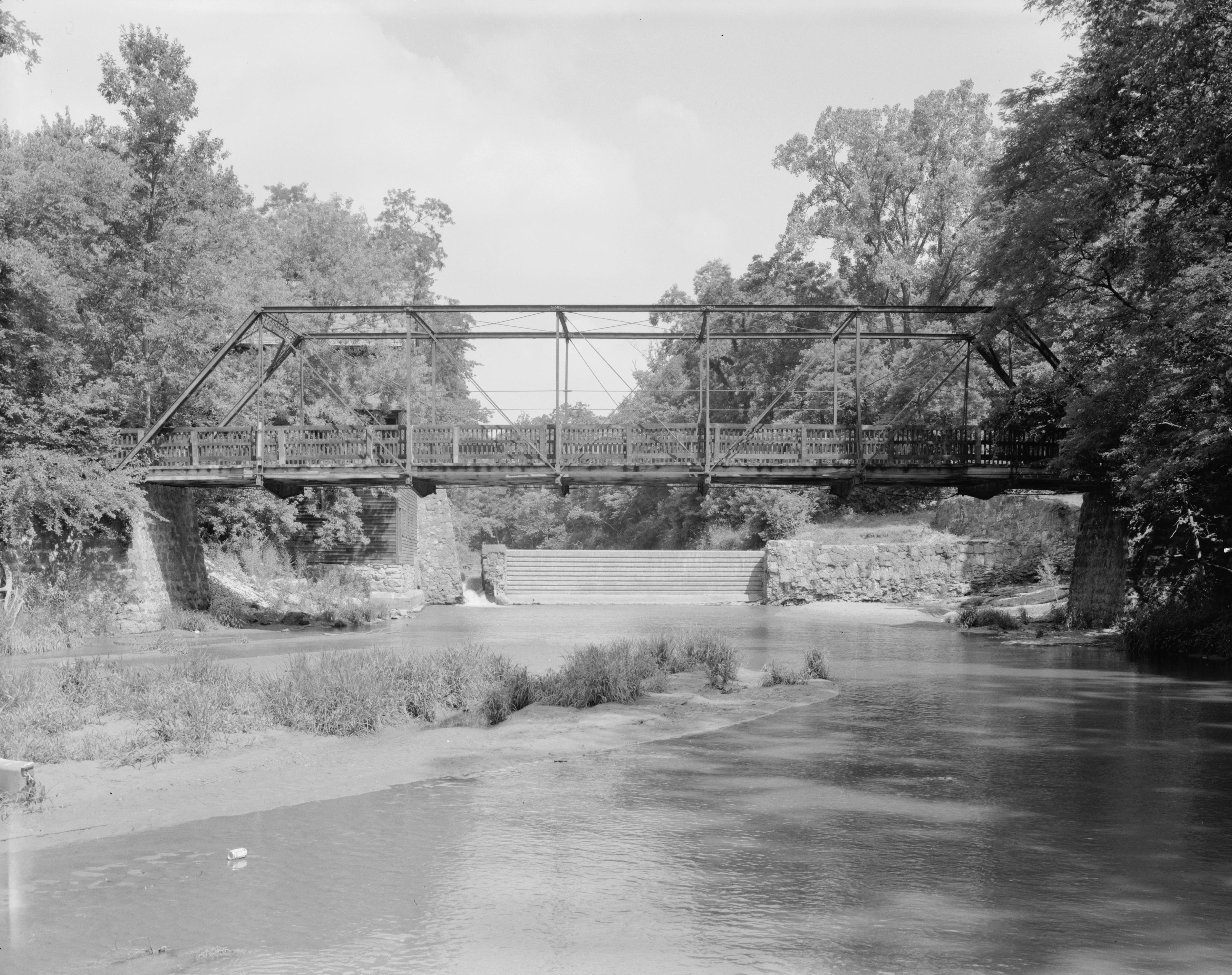
English: Southern (downstream) side of the Pine Mill Bridge, which carries a footpath over Pine Creek in Wildcat Den State Park, just above the Mississippi River above Muscatine in Muscatine County, Iowa, United States. Notice the dam in the background, a remnant of a nearby abandoned mill. Built in 1878, this pinned Pratt through truss bridge is listed on the National Register of Historic Places.
Tarix
Summer 1995
date QS:P,+1995-00-00T00:00:00Z/9,P4241,Q40720564
Mənbə
Library of Congress, Prints and Photograph Division HAER: IOWA,70-MUSCA.V,2-1
Müəllif
Joseph Elliott
İcazə (Faylın təkrar istifadəsi)
Public domainPublic domainfalsefalse
Creator: U.S. Department of the Interior, National Park Service, Historic American Engineering Record. Survey number HAER IA-69-1
Source: U.S. Library of Congress, Prints and Photographs Division, "Built in America" Collection.
Copyright: "The original measured drawings and most of the photographs and data pages in HABS/HAER/HALS were created for the U.S. Government and are considered to be in the public domain."
This image is available from the United States Library of Congress's Prints and Photographs division under the digital ID hhh.ia0445. This tag does not indicate the copyright status of the attached work. A normal copyright tag is still required. See Commons:Licensing for more information.
العربية ∙ беларуская (тарашкевіца) ∙ čeština ∙ Deutsch ∙ English ∙ español ∙ فارسی ∙ suomi ∙ français ∙ galego ∙ עברית ∙ magyar ∙ Bahasa Indonesia ∙ italiano ∙ 日本語 ∙ lietuvių ∙ македонски ∙ മലയാളം ∙ Nederlands ∙ polski ∙ português ∙ português do Brasil ∙ română ∙ русский ∙ sicilianu ∙ slovenčina ∙ slovenščina ∙ Türkçe ∙ українська ∙ 中文(简体) ∙ 中文(繁體) ∙ +/−
Captions
Add a one-line explanation of what this file represents
Items portrayed in this file
təsvir edir
copyright status ingilis
ictimai varidat
coordinates of the point of view ingilis
41°28'3.000"N, 90°52'3.000"W
Faylın tarixçəsi
Faylın əvvəlki versiyasını görmək üçün gün/tarix bölməsindəki tarixlərə klikləyin.
{{Location|41|28|3|N|90|52|3|W}} {{Information |Description={{en|Southern (downstream) side of the {{w|Pine Mill Bridge}}, which carries a footpath over Pine Creek in {{w|Wildcat Den State Park}}, just above the {{w|Mississippi River}} above {{w|Muscatine
Bu faylda fotoaparat və ya skanerlə əlavə olunmuş məlumatlar var. Əgər fayl sonradan redaktə olunubsa, bəzi parametrlər bu şəkildə göstərilənlərdən fərqli ola bilər.
Genişlik
5.000 px
Hündürlük
4.070 px
Bits per component
8
Sıxılmamış
Sıxılmış
Rəng modeli
Black and white (Black is 0)
Orientasiya
Normal
Hər blokdakı sətirlərin sayı
13
Üfüqi xətt
5.000 dpc
Şaquli xətt
4.070 dpc
Data arrangement
chunky format
Faylın dəyişməsi tarixi və vaxtı
15:30, 11 fevral 2002
Fevral 13, 2023
fayl, pine, mill, bridge, fayl, faylın, tarixçəsi, fayl, keçidləri, faylın, qlobal, istifadəsi, metaməlumatlarsınaq, göstərişi, ölçüsü, piksel, digər, ölçülər, piksel, piksel, piksel, piksel, piksel, piksel, faylın, orijinalı, 8206, piksel, fayl, həcmi, mime, . Fayl Faylin tarixcesi Fayl kecidleri Faylin qlobal istifadesi MetamelumatlarSinaq gosterisi olcusu 758 600 piksel Diger olculer 303 240 piksel 607 480 piksel 971 768 piksel 1 280 1 013 piksel 2 560 2 025 piksel 4 693 3 713 piksel Faylin orijinali 8206 4 693 3 713 piksel fayl hecmi 1 89 MB MIME novu image jpeg Bu fayl Vikimedia Commons dadirve diger layihelerde istifade edile biler Faylin tesvir sehifesine get Camera location41 28 03 N 90 52 03 W View this and other nearby images on OpenStreetMap41 467500 90 867500IzahPine Mill Bridge jpg English Southern downstream side of the Pine Mill Bridge which carries a footpath over Pine Creek in Wildcat Den State Park just above the Mississippi River above Muscatine in Muscatine County Iowa United States Notice the dam in the background a remnant of a nearby abandoned mill Built in 1878 this pinned Pratt through truss bridge is listed on the National Register of Historic Places Tarix Summer 1995 date QS P 1995 00 00T00 00 00Z 9 P4241 Q40720564Menbe Library of Congress Prints and Photograph Division HAER IOWA 70 MUSCA V 2 1Muellif Joseph ElliottIcaze Faylin tekrar istifadesi Public domain Public domain false falseThis image or media file contains material based on a work of a National Park Service employee created as part of that person s official duties As a work of the U S federal government such work is in the public domain in the United States See the NPS website and NPS copyright policy for more information Creator U S Department of the Interior National Park Service Historic American Engineering Record Survey number HAER IA 69 1 Source U S Library of Congress Prints and Photographs Division Built in America Collection Copyright The original measured drawings and most of the photographs and data pages in HABS HAER HALS were created for the U S Government and are considered to be in the public domain This image is available from the United States Library of Congress s Prints and Photographs division under the digital ID hhh ia0445 This tag does not indicate the copyright status of the attached work A normal copyright tag is still required See Commons Licensing for more information العربية belaruskaya tarashkevica cestina Deutsch English espanol فارسی suomi francais galego עברית magyar Bahasa Indonesia italiano 日本語 lietuviu makedonski മലയ ള Nederlands polski portugues portugues do Brasil romană russkij sicilianu slovencina slovenscina Turkce ukrayinska 中文 简体 中文 繁體 CaptionsazerbaycancaAdd a one line explanation of what this file representsItems portrayed in this filetesvir edircopyright status ingilisictimai varidatcoordinates of the point of view ingilis41 28 3 000 N 90 52 3 000 W Faylin tarixcesi Faylin evvelki versiyasini gormek ucun gun tarix bolmesindeki tarixlere klikleyin Tarix VaxtKicik sekilOlculerIstifadeciSerh indiki06 31 9 oktyabr 20094 693 3 713 1 89 MB Cropbotupload cropped version operated by User Finavon Summary border cropped 02 25 28 sentyabr 20095 000 4 070 2 19 MB Nyttend Location 41 28 3 N 90 52 3 W Information Description en Southern downstream side of the w Pine Mill Bridge which carries a footpath over Pine Creek in w Wildcat Den State Park just above the w Mississippi River above w Muscatine Fayl kecidleri Bu sekile olan kecidler Uildket Den Stat Parki Faylin qlobal istifadesi Bu fayl asagidaki vikilerde istifade olunur en wikipedia org layihesinde istifadesi List of bridges on the National Register of Historic Places in IowaMetamelumatlar Bu faylda fotoaparat ve ya skanerle elave olunmus melumatlar var Eger fayl sonradan redakte olunubsa bezi parametrler bu sekilde gosterilenlerden ferqli ola biler Genislik5 000 pxHundurluk4 070 pxBits per component8SixilmamisSixilmisReng modeliBlack and white Black is 0 OrientasiyaNormalHer blokdaki setirlerin sayi13Ufuqi xett5 000 dpcSaquli xett4 070 dpcData arrangementchunky formatFaylin deyismesi tarixi ve vaxti15 30 11 fevral 2002 Menbe https az wikipedia org wiki Fayl Pine Mill Bridge jpg, wikipedia, oxu, kitab, kitabxana, axtar, tap, hersey,
ne axtarsan burda
, en yaxsi meqale sayti, meqaleler, kitablar, oyrenmek, wiki, bilgi, tarix, seks, porno, indir, yukle, sex, azeri sex, azeri, seks yukle, sex yukle, izle, seks izle, porno izle, mobil seks, telefon ucun, chat, azeri chat, tanisliq, tanishliq, azeri tanishliq, sayt, medeni, medeni saytlar, chatlar, mekan, tanisliq mekani, mekanlari, yüklə, pulsuz, pulsuz yüklə, mp3, video, mp4, 3gp, jpg, jpeg, gif, png, şəkil, muisiqi, mahnı, kino, film, kitab, oyun, oyunlar.