Bu fayl "Vikimedia Commons"dadır və digər layihələrdə istifadə edilə bilər.
Faylın təsvir səhifəsinə get
Xülasə
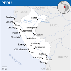
İzahPeru - Location Map (2011) - PER - UNOCHA.svg
English: Locator map of Peru.
Tarix
Mənbə
English: Peru Locator Map (ReliefWeb)
Müəllif
English: UN Office for the Coordination of Humanitarian Affairs (OCHA)
SVG genesis
InfoField
The SVG code is valid.
This map was created with Inkscape.
This map uses embedded text that can be easily translated using a text editor.
Lisenziya
This file is licensed under the Creative Commons Attribution 3.0 Unported license.
İstinad: OCHA
Azadsınız:
paylaşmaq – əsəri köçürmək, paylamaq və ötürmək üçün
remiks etmək – əsəri adaptasiya etmək
Aşağıdakı şərtlərə riayət etməklə:
istinad – Müvafiq kredit verməlisiniz, lisenziyaya bir keçid verməlisiniz və dəyişikliklərin olub olmadığını bildirməlisiniz. Bunu hər hansı bir ağlabatan şəkildə edə bilərsiniz, ancaq lisenziyalaşdırıcının sizi və ya istifadənizi təsdiqləməsini təklif edən bir şəkildə deyil.
https://creativecommons.org/licenses/by/3.0CC BY 3.0 Creative Commons Attribution 3.0 truetrue
This map is part of a collection of 216 free country maps, created by the UN Office for the Coordination of Humanitarian Affairs (OCHA), to be used in print, web or broadcast products.
The ReliefWeb Location Maps released here are maps that highlight a country, its capital, major populated places and the surrounding regions.
Attribution Requirements
Using the map without modifications: ensure that the sources and the disclaimer are below the map. Credit as follows: "Credit: OCHA".
For use with alteration: remove the OCHA logo and disclaimer following any modification to the map, but keep the data sources as mentioned below the map. Credit the modified map as follows: "Based on OCHA map". You are responsible for the content of your map.
We are keen to receive your feedback and hear how you used OCHA's maps. We would be grateful if you would notify us by e-mail and share your work with us.
UN Disclaimer
The designations employed and the presentation of material of this map do not imply the expression of any opinion whatsoever on the part of the Secretariat of the United Nations concerning the legal status of any country, territory, city or area or of its authorities or concerning the delimitation of its frontiers or boundaries.
This work is free and may be used by anyone for any purpose. If you wish to use this content, you do not need to request permission as long as you follow any licensing requirements mentioned on this page.
The Wikimedia Foundation has received an e-mail confirming that the copyright holder has approved publication under the terms mentioned on this page. This correspondence has been reviewed by a Volunteer Response Team (VRT) member and stored in our permission archive. The correspondence is available to trusted volunteers as ticket #2014031410007248.
If you have questions about the archived correspondence, please use the VRT noticeboard. Ticket link: https://ticket.wikimedia.org/otrs/index.pl?Action=AgentTicketZoom&TicketNumber=2014031410007248 Find other files from the same ticket:
Captions
Add a one-line explanation of what this file represents
Bu faylda fotoaparat və ya skanerlə əlavə olunmuş məlumatlar var. Əgər fayl sonradan redaktə olunubsa, bəzi parametrlər bu şəkildə göstərilənlərdən fərqli ola bilər.
Genişlik
250.3125
Hündürlük
250.3125
Aprel 21, 2023
fayl, peru, location, 2011, unocha, fayl, faylın, tarixçəsi, fayl, keçidləri, faylın, qlobal, istifadəsi, metaməlumatlarbu, faylın, formatındakı, görünüşünün, ölçüsü, piksel, digər, ölçülər, piksel, piksel, piksel, piksel, piksel, faylın, orijinalı, 8206, fayl. Fayl Faylin tarixcesi Fayl kecidleri Faylin qlobal istifadesi MetamelumatlarBu SVG faylin PNG formatindaki bu gorunusunun olcusu 250 250 piksel Diger olculer 240 240 piksel 480 480 piksel 768 768 piksel 1 024 1 024 piksel 2 048 2 048 piksel Faylin orijinali 8206 SVG fayli nominal olaraq 250 250 piksel faylin olcusu 362 KB Bu fayl Vikimedia Commons dadirve diger layihelerde istifade edile biler Faylin tesvir sehifesine get Xulase IzahPeru Location Map 2011 PER UNOCHA svg English Locator map of Peru Tarix 2011 Menbe English Peru Locator Map ReliefWeb Muellif English UN Office for the Coordination of Humanitarian Affairs OCHA SVG nbsp genesisInfoField nbsp The SVG code is valid nbsp This map was created with Inkscape nbsp This map uses embedded text nbsp that can be easily translated using a text editor Lisenziya This file is licensed under the Creative Commons Attribution 3 0 Unported license Istinad OCHAAzadsiniz paylasmaq eseri kocurmek paylamaq ve oturmek ucun remiks etmek eseri adaptasiya etmek Asagidaki sertlere riayet etmekle istinad Muvafiq kredit vermelisiniz lisenziyaya bir kecid vermelisiniz ve deyisikliklerin olub olmadigini bildirmelisiniz Bunu her hansi bir aglabatan sekilde ede bilersiniz ancaq lisenziyalasdiricinin sizi ve ya istifadenizi tesdiqlemesini teklif eden bir sekilde deyil https creativecommons org licenses by 3 0 CC BY 3 0 Creative Commons Attribution 3 0 true true This map is part of a collection of 216 free country maps created by the UN Office for the Coordination of Humanitarian Affairs OCHA to be used in print web or broadcast products The ReliefWeb Location Maps released here are maps that highlight a country its capital major populated places and the surrounding regions Attribution Requirements Using the map without modifications ensure that the sources and the disclaimer are below the map Credit as follows Credit OCHA For use with alteration remove the OCHA logo and disclaimer following any modification to the map but keep the data sources as mentioned below the map Credit the modified map as follows Based on OCHA map You are responsible for the content of your map We are keen to receive your feedback and hear how you used OCHA s maps We would be grateful if you would notify us by e mail and share your work with us UN Disclaimer The designations employed and the presentation of material of this map do not imply the expression of any opinion whatsoever on the part of the Secretariat of the United Nations concerning the legal status of any country territory city or area or of its authorities or concerning the delimitation of its frontiers or boundaries nbsp This work is free and may be used by anyone for any purpose If you wish to use this content you do not need to request permission as long as you follow any licensing requirements mentioned on this page The Wikimedia Foundation has received an e mail confirming that the copyright holder has approved publication under the terms mentioned on this page This correspondence has been reviewed by a Volunteer Response Team VRT member and stored in our permission archive The correspondence is available to trusted volunteers nbsp as ticket 2014031410007248 If you have questions about the archived correspondence please use the VRT noticeboard Ticket link https ticket wikimedia org otrs index pl Action AgentTicketZoom amp TicketNumber 2014031410007248 Find other files from the same ticket CaptionsazerbaycancaAdd a one line explanation of what this file representsItems portrayed in this filetesvir edircopyright status nbsp ingiliscopyrighted nbsp ingilislisenziyaCreative Commons Attribution 3 0 Unported nbsp ingilisWikimedia VRTS ticket number nbsp ingilis2014031410007248yaranma tarixi2011MIME type nbsp ingilisimage svg xml Faylin tarixcesi Faylin evvelki versiyasini gormek ucun gun tarix bolmesindeki tarixlere klikleyin Tarix VaxtKicik sekilOlculerIstifadeciSerh indiki13 54 7 sentyabr 2016250 250 362 KB Wereldburger758Resized page to drawing Removal watermark Validation of image 00 47 8 may 2014254 254 389 KB UN OCHA maps bot int filedesc Information description en 1 Locator map of Peru date 2011 source en 1 http reliefweb int map peru peru location map 2011 Peru Locator Map ReliefWeb author en 1 w en United Nations Office fo Fayl kecidleri Bu sekile olan kecidler Peru Faylin qlobal istifadesi Bu fayl asagidaki vikilerde istifade olunur es wikipedia org layihesinde istifadesi Frontera entre Bolivia y Peru Frontera entre Brasil y Peru id wikipedia org layihesinde istifadesi Peru Templat Peru infobox mn wikipedia org layihesinde istifadesi Peru ms wikipedia org layihesinde istifadesi Peru sd wikipedia org layihesinde istifadesi پيرو ملڪ vi wikipedia org layihesinde istifadesi PeruMetamelumatlar Bu faylda fotoaparat ve ya skanerle elave olunmus melumatlar var Eger fayl sonradan redakte olunubsa bezi parametrler bu sekilde gosterilenlerden ferqli ola biler Genislik250 3125Hundurluk250 3125 Menbe https az wikipedia org wiki Fayl Peru Location Map 2011 PER UNOCHA svg, wikipedia, oxu, kitab, kitabxana, axtar, tap, hersey,
ne axtarsan burda
, en yaxsi meqale sayti, meqaleler, kitablar, oyrenmek, wiki, bilgi, tarix, seks, porno, indir, yukle, sex, azeri sex, azeri, seks yukle, sex yukle, izle, seks izle, porno izle, mobil seks, telefon ucun, chat, azeri chat, tanisliq, tanishliq, azeri tanishliq, sayt, medeni, medeni saytlar, chatlar, mekan, tanisliq mekani, mekanlari, yüklə, pulsuz, pulsuz yüklə, mp3, video, mp4, 3gp, jpg, jpeg, gif, png, şəkil, muisiqi, mahnı, kino, film, kitab, oyun, oyunlar.