Bu fayl "Vikimedia Commons"dadır və digər layihələrdə istifadə edilə bilər.
Faylın təsvir səhifəsinə get
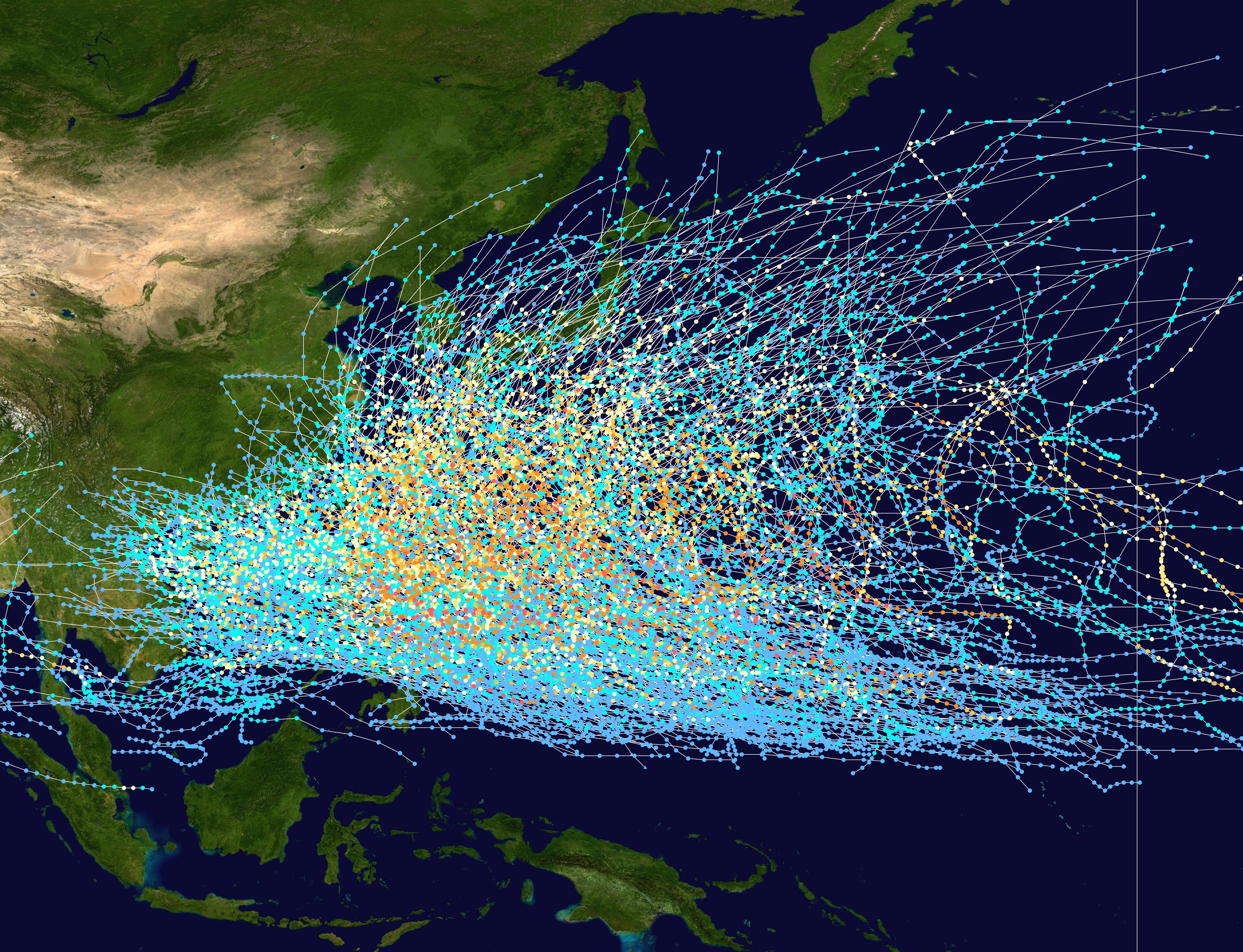
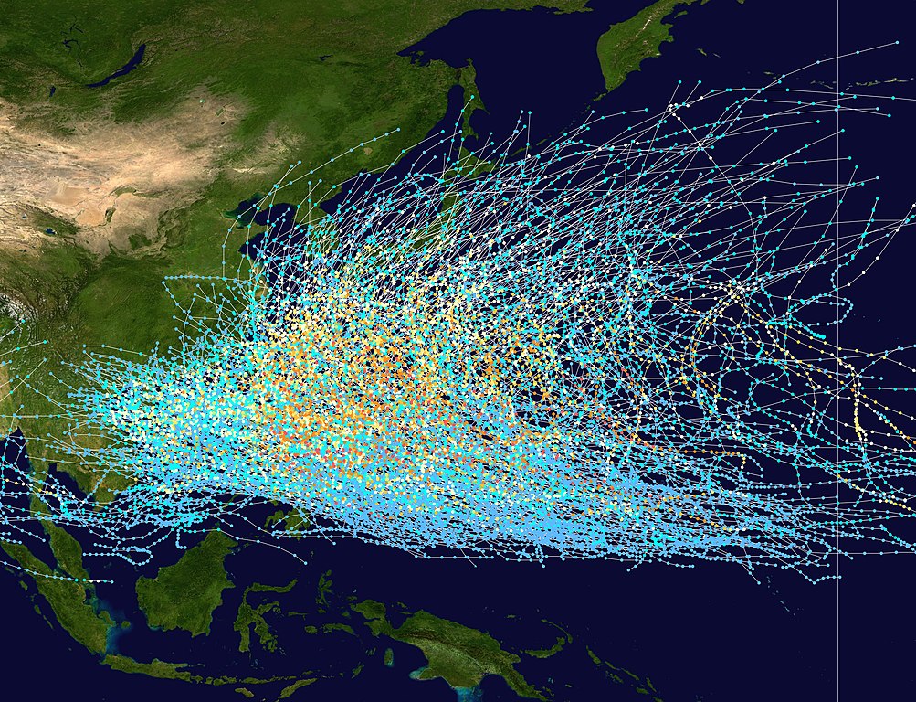
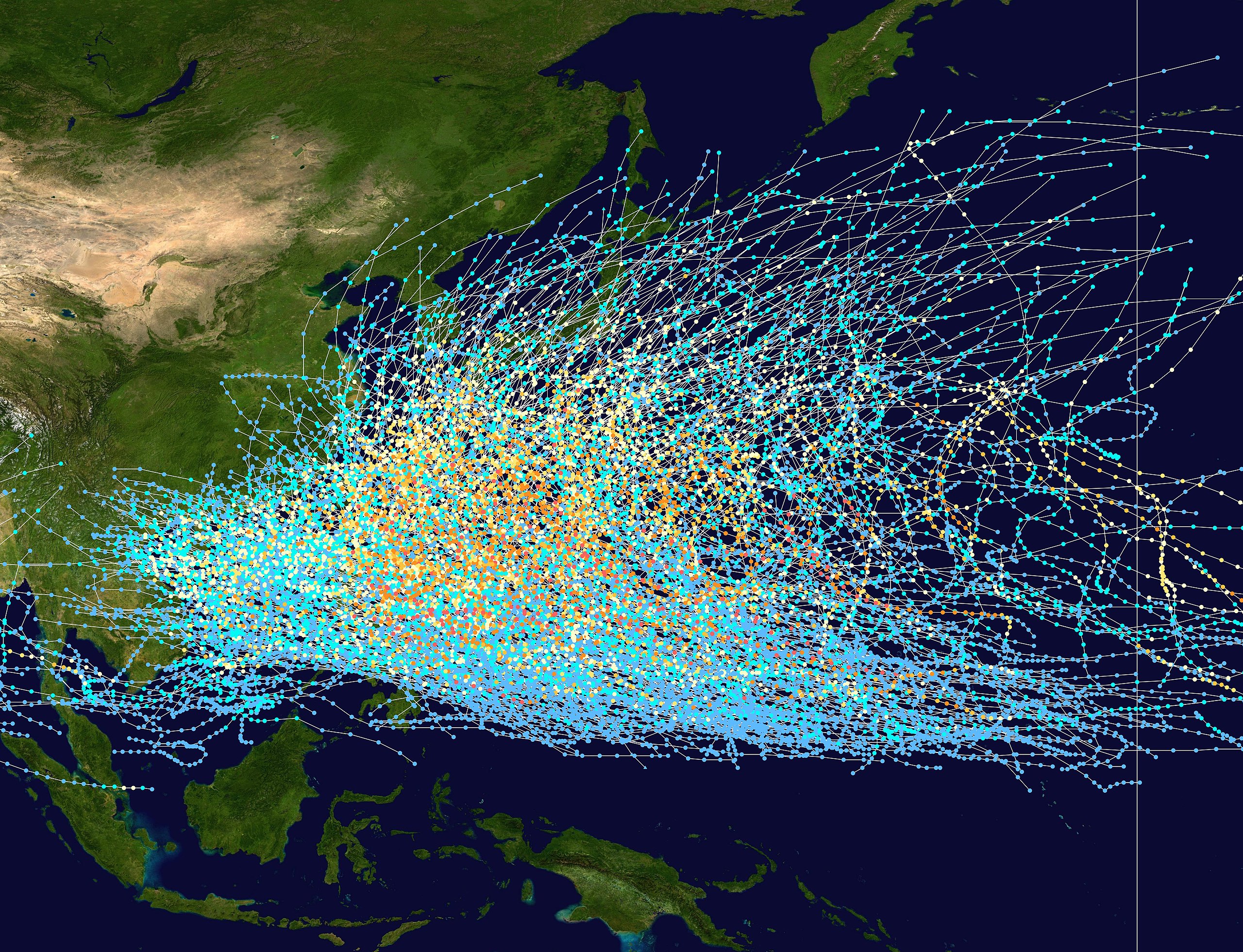
İzahPacific typhoon tracks 1980-2005.jpg
English: This trackmap shows the tracks of all tropical cyclones in the Northwest Pacific Ocean from 1980 to 2005. The International Date Line is marked on the map, this is the eastern boundary of the basin.. The points show the location of each storm at 6-hour intervals. The colour represents the storm's maximum sustained wind speeds as classified in the Saffir-Simpson Hurricane Scale (see below), and the shape of the data points represent the nature of the storm.
Created using WikiProject Tropical cyclones/Tracks. The background image is from NASA [1]. The tracking data is from the Joint Typhoon Warning Center's best track database
Müəllif
Nilfanion
Licensing:
Public domainPublic domainfalsefalse
Captions
Add a one-line explanation of what this file represents
Typhoon Tracks in the Western Pacific
Items portrayed in this file
təsvir edir
copyright status ingilis
copyrighted, dedicated to the public domain by copyright holder ingilis
lisenziya
released into the public domain by the copyright holder ingilis
Faylın tarixçəsi
Faylın əvvəlki versiyasını görmək üçün gün/tarix bölməsindəki tarixlərə klikləyin.
Wikipedia:Reference desk/Archives/Science/2011 June 20
User:AleahHahn/Kuroshio Current
Alerte cyclonique
ტაიფუნი (ციკლონი)
Тайфун
Avisos e alertas de ciclone tropical
Тайфун
Бассейны тропических циклонов
แอ่งพายุหมุนเขตร้อน
Тайфун
Bão nhiệt đới Tây Bắc Thái Bình Dương
Metaməlumatlar
Bu faylda fotoaparat və ya skanerlə əlavə olunmuş məlumatlar var. Əgər fayl sonradan redaktə olunubsa, bəzi parametrlər bu şəkildə göstərilənlərdən fərqli ola bilər.
_error
0
Yanvar 09, 2023
fayl, pacific, typhoon, tracks, 1980, 2005, fayl, faylın, tarixçəsi, istifadə, edilən, səhifələr, faylın, qlobal, istifadəsi, metaməlumatlarsınaq, göstərişi, ölçüsü, piksel, digər, ölçülər, piksel, piksel, piksel, piksel, piksel, piksel, faylın, orijinalı, 820. Fayl Faylin tarixcesi Istifade edilen sehifeler Faylin qlobal istifadesi MetamelumatlarSinaq gosterisi olcusu 783 600 piksel Diger olculer 313 240 piksel 627 480 piksel 1 003 768 piksel 1 280 980 piksel 2 560 1 961 piksel 4 700 3 600 piksel Faylin orijinali 8206 4 700 3 600 piksel fayl hecmi 4 04 MB MIME novu image jpeg Bu fayl Vikimedia Commons dadirve diger layihelerde istifade edile biler Faylin tesvir sehifesine get IzahPacific typhoon tracks 1980 2005 jpg English This trackmap shows the tracks of all tropical cyclones in the Northwest Pacific Ocean from 1980 to 2005 The International Date Line is marked on the map this is the eastern boundary of the basin The points show the location of each storm at 6 hour intervals The colour represents the storm s maximum sustained wind speeds as classified in the Saffir Simpson Hurricane Scale see below and the shape of the data points represent the nature of the storm Saffir Simpson scale Tropical depression 38 mph 62 km h Tropical storm 39 73 mph 63 118 km h Category 1 74 95 mph 119 153 km h Category 2 96 110 mph 154 177 km h Category 3 111 129 mph 178 208 km h Category 4 130 156 mph 209 251 km h Category 5 157 mph 252 km h Unknown Storm type Tropical cyclone Subtropical cyclone Extratropical cyclone Remnant low Tropical disturbance Monsoon depressionTarix 1980 2005Menbe Created using WikiProject Tropical cyclones Tracks The background image is from NASA 1 The tracking data is from the Joint Typhoon Warning Center s best track databaseMuellif Nilfanion Licensing Public domain Public domain false falseThis work has been released into the public domain by its author Nilfanion This applies worldwide In some countries this may not be legally possible if so Nilfanion grants anyone the right to use this work for any purpose without any conditions unless such conditions are required by law CaptionsazerbaycancaAdd a one line explanation of what this file representsingilisTyphoon Tracks in the Western PacificItems portrayed in this filetesvir edircopyright status ingiliscopyrighted dedicated to the public domain by copyright holder ingilislisenziyareleased into the public domain by the copyright holder ingilis Faylin tarixcesi Faylin evvelki versiyasini gormek ucun gun tarix bolmesindeki tarixlere klikleyin Tarix VaxtKicik sekilOlculerIstifadeciSerh indiki21 21 27 fevral 20074 700 3 600 4 04 MB Nilfanion Description align align right border 0 cellspacing 0 cellpadding 0 style background transparent text align center colspan 7 nowrap nowrap lt small gt Saffir Simpson Hurricane Scale lt small gt s Istifade edilen sehifeler Bu sekile olan kecidler Tayfun qasirgasi Faylin qlobal istifadesi Bu fayl asagidaki vikilerde istifade olunur be tarask wikipedia org layihesinde istifadesi Tajfun be wikipedia org layihesinde istifadesi Tajfun en wikipedia org layihesinde istifadesi Kuroshio Current Pacific typhoon season Typhoon Tropical cyclone basins Wikipedia Reference desk Archives Science 2011 June 20 User AleahHahn Kuroshio Current fr wikipedia org layihesinde istifadesi Nomenclature des cyclones tropicaux Alerte cyclonique hak wikipedia org layihesinde istifadesi Thoi fung hy wikipedia org layihesinde istifadesi Խաղաղ օվկիանոս ja wikipedia org layihesinde istifadesi 台風 ka wikipedia org layihesinde istifadesi წყნარი ოკეანე ტაიფუნი ციკლონი kk wikipedia org layihesinde istifadesi Tynyk muhit Tajfun krc wikipedia org layihesinde istifadesi Shosh okean lez wikipedia org layihesinde istifadesi Las okean ms wikipedia org layihesinde istifadesi Taufan pt wikipedia org layihesinde istifadesi Bacia de formacao de ciclones tropicais Avisos e alertas de ciclone tropical ru wikipedia org layihesinde istifadesi Tihij okean Tajfun Bassejny tropicheskih ciklonov th wikipedia org layihesinde istifadesi phayuitfunaepsifik aexngphayuhmunekhtrxn tl wikipedia org layihesinde istifadesi Tala ng panahon ng bagyo sa hilagang kanlurang Pasipiko tyv wikipedia org layihesinde istifadesi Oozhum okean uk wikipedia org layihesinde istifadesi Basejni tropichnih cikloniv Tajfun uz wikipedia org layihesinde istifadesi Tayfun vi wikipedia org layihesinde istifadesi Danh sach mua bao Tay Bắc Thai Binh Dương Bao nhiệt đới Tay Bắc Thai Binh Dương zh wikipedia org layihesinde istifadesi 颱風Metamelumatlar Bu faylda fotoaparat ve ya skanerle elave olunmus melumatlar var Eger fayl sonradan redakte olunubsa bezi parametrler bu sekilde gosterilenlerden ferqli ola biler error0 Menbe https az wikipedia org wiki Fayl Pacific typhoon tracks 1980 2005 jpg, wikipedia, oxu, kitab, kitabxana, axtar, tap, hersey,
ne axtarsan burda
, en yaxsi meqale sayti, meqaleler, kitablar, oyrenmek, wiki, bilgi, tarix, seks, porno, indir, yukle, sex, azeri sex, azeri, seks yukle, sex yukle, izle, seks izle, porno izle, mobil seks, telefon ucun, chat, azeri chat, tanisliq, tanishliq, azeri tanishliq, sayt, medeni, medeni saytlar, chatlar, mekan, tanisliq mekani, mekanlari, yüklə, pulsuz, pulsuz yüklə, mp3, video, mp4, 3gp, jpg, jpeg, gif, png, şəkil, muisiqi, mahnı, kino, film, kitab, oyun, oyunlar.