Bu fayl "Vikimedia Commons"dadır və digər layihələrdə istifadə edilə bilər.
Faylın təsvir səhifəsinə get
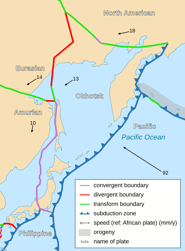
İzahOkhotsk Plate map en.png
English: Area around Okhotsk plate.
Tarix
(UTC)
Mənbə
Tectonic_plates_boundaries_detailed-fr.svg
Müəllif
derivative work: Psbsub (talk)
Tectonic_plates_boundaries_detailed-fr.svg: Eric Gaba (Sting)
Digər versiyalar
Derivative works of this file:
Okhotsk Plate map he.jpg
Philippine Sea Plate br.JPG
Bu təsvirin redaktəsi, orijinala əsaslanaraq rəqəmsal qaydadadır. Dəyişiklik: Same as File:Tectonic_plates_boundaries_detailed-fr.svg except in English. İlkin təsvir buradadır: Tectonic plates boundaries detailed-fr.svg. Redaktə etdi Psbsub.
I, the copyright holder of this work, hereby publish it under the following license:
This file is licensed under the Creative Commons Attribution-Share Alike 2.5 Generic license.
Azadsınız:
paylaşmaq – əsəri köçürmək, paylamaq və ötürmək üçün
remiks etmək – əsəri adaptasiya etmək
Aşağıdakı şərtlərə riayət etməklə:
istinad – Müvafiq kredit verməlisiniz, lisenziyaya bir keçid verməlisiniz və dəyişikliklərin olub olmadığını bildirməlisiniz. Bunu hər hansı bir ağlabatan şəkildə edə bilərsiniz, ancaq lisenziyalaşdırıcının sizi və ya istifadənizi təsdiqləməsini təklif edən bir şəkildə deyil.
bənzər paylaşma – Əsəri remix edirsinizsə, dəyişdirirsinizsə və ya üzərində iş aparırsınızsa, öz töhfələrinizi orijinalda olduğu kimi eyni və ya uyğun lisenziya altında yayımlamalısınız.
2006-10-25T13:56:52Z Sting 5000x2525 (854406 Bytes) Lighter version
2006-10-25T00:43:14Z Sting 5000x2525 (936674 Bytes) {{Information| |Description=Detailed world map in French showing the tectonic plates with their movement vectors |Source= '''Background map (modified) :''' [[:Image:Tectonic plates (empty).svg]] created by [[User:Ævar Arnfj�
Uploaded with derivativeFX
Captions
Add a one-line explanation of what this file represents
Items portrayed in this file
təsvir edir
copyright status ingilis
copyrighted ingilis
lisenziya
Creative Commons Attribution-ShareAlike 2.5 Generic ingilis
Faylın tarixçəsi
Faylın əvvəlki versiyasını görmək üçün gün/tarix bölməsindəki tarixlərə klikləyin.
fayl, okhotsk, plate, fayl, faylın, tarixçəsi, fayl, keçidləri, faylın, qlobal, istifadəsisınaq, göstərişi, ölçüsü, piksel, digər, ölçülər, piksel, piksel, faylın, orijinalı, 8206, piksel, fayl, həcmi, mime, növü, image, fayl, vikimedia, commons, dadırvə, digə. Fayl Faylin tarixcesi Fayl kecidleri Faylin qlobal istifadesiSinaq gosterisi olcusu 443 600 piksel Diger olculer 177 240 piksel 628 850 piksel Faylin orijinali 8206 628 850 piksel fayl hecmi 40 KB MIME novu image png Bu fayl Vikimedia Commons dadirve diger layihelerde istifade edile biler Faylin tesvir sehifesine get IzahOkhotsk Plate map en png English Area around Okhotsk plate Tarix 1 yanvar 2009 22 05 UTC Menbe Tectonic plates boundaries detailed fr svg Muellif derivative work Psbsub talk Tectonic plates boundaries detailed fr svg Eric Gaba Sting Diger versiyalar Derivative works of this file Okhotsk Plate map he jpg Philippine Sea Plate br JPG Bu tesvirin redaktesi orijinala esaslanaraq reqemsal qaydadadir Deyisiklik Same as File Tectonic plates boundaries detailed fr svg except in English Ilkin tesvir buradadir Tectonic plates boundaries detailed fr svg Redakte etdi Psbsub nbsp I the copyright holder of this work hereby publish it under the following license This file is licensed under the Creative Commons Attribution Share Alike 2 5 Generic license Azadsiniz paylasmaq eseri kocurmek paylamaq ve oturmek ucun remiks etmek eseri adaptasiya etmek Asagidaki sertlere riayet etmekle istinad Muvafiq kredit vermelisiniz lisenziyaya bir kecid vermelisiniz ve deyisikliklerin olub olmadigini bildirmelisiniz Bunu her hansi bir aglabatan sekilde ede bilersiniz ancaq lisenziyalasdiricinin sizi ve ya istifadenizi tesdiqlemesini teklif eden bir sekilde deyil benzer paylasma Eseri remix edirsinizse deyisdirirsinizse ve ya uzerinde is aparirsinizsa oz tohfelerinizi orijinalda oldugu kimi eyni ve ya uygun lisenziya altinda yayimlamalisiniz https creativecommons org licenses by sa 2 5 CC BY SA 2 5 Creative Commons Attribution Share Alike 2 5 true true Orijinal yukleme gundeliyi This image is a derivative work of the following images File Tectonic plates boundaries detailed fr svg licensed with Cc by sa 2 5 Cc by sa 2 5 en 2008 08 31T23 27 25Z Sting 4896x2471 790111 Bytes A bit smaller to export in PNG 2008 06 02T20 24 47Z Sting 5000x2525 850547 Bytes South NZ subduction zone correction 2006 10 25T14 23 54Z Sting 5000x2525 853764 Bytes Forgotten arrow 2006 10 25T13 56 52Z Sting 5000x2525 854406 Bytes Lighter version 2006 10 25T00 43 14Z Sting 5000x2525 936674 Bytes Information Description Detailed world map in French showing the tectonic plates with their movement vectors Source Background map modified nbsp Image Tectonic plates empty svg created by User AEvar Arnfj Uploaded with derivativeFXCaptionsazerbaycancaAdd a one line explanation of what this file representsItems portrayed in this filetesvir edircopyright status nbsp ingiliscopyrighted nbsp ingilislisenziyaCreative Commons Attribution ShareAlike 2 5 Generic nbsp ingilis Faylin tarixcesi Faylin evvelki versiyasini gormek ucun gun tarix bolmesindeki tarixlere klikleyin Tarix VaxtKicik sekilOlculerIstifadeciSerh indiki22 06 1 yanvar 2009628 850 40 KB Psbsub Information Description en Area around Okhotsk plate Source File Tectonic plates boundaries detailed fr svg Date 2009 01 01 22 05 UTC Author derivative work File Tectonic plates boundaries detailed fr svg Eric Gaba Use Fayl kecidleri Bu sekile olan kecidler Oxot plitesi Faylin qlobal istifadesi Bu fayl asagidaki vikilerde istifade olunur de wikipedia org layihesinde istifadesi Diskussion Tōhoku Erdbeben 2011 Archiv 1 Wikipedia Kartenwerkstatt Archiv 2011 03 en wikipedia org layihesinde istifadesi Geology of Russia Eastern margin of the Sea of Japan eu wikipedia org layihesinde istifadesi Okhotskeko plaka pl wikipedia org layihesinde istifadesi Plyta ochocka ru wikipedia org layihesinde istifadesi Ohotskaya plita sh wikipedia org layihesinde istifadesi Ohotska ploca vi wikipedia org layihesinde istifadesi Mảng Okhotsk Menbe https az wikipedia org wiki Fayl Okhotsk Plate map en png, wikipedia, oxu, kitab, kitabxana, axtar, tap, hersey,
ne axtarsan burda
, en yaxsi meqale sayti, meqaleler, kitablar, oyrenmek, wiki, bilgi, tarix, seks, porno, indir, yukle, sex, azeri sex, azeri, seks yukle, sex yukle, izle, seks izle, porno izle, mobil seks, telefon ucun, chat, azeri chat, tanisliq, tanishliq, azeri tanishliq, sayt, medeni, medeni saytlar, chatlar, mekan, tanisliq mekani, mekanlari, yüklə, pulsuz, pulsuz yüklə, mp3, video, mp4, 3gp, jpg, jpeg, gif, png, şəkil, muisiqi, mahnı, kino, film, kitab, oyun, oyunlar.