Bu fayl "Vikimedia Commons"dadır və digər layihələrdə istifadə edilə bilər.
Faylın təsvir səhifəsinə get
Xülasə
This locator map image could be re-created using vector graphics as an SVG file. This has several advantages; see Commons:Media for cleanup for more information. If an SVG form of this image is available, please upload it and afterwards replace this template with {{vector version available|new image name}}. It is recommended to name the SVG file "Mojave-sonoran deserts.svg" – then the template Vector version available (or Vva) does not need the new image name parameter.
İzahMojave-sonoran deserts.png
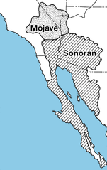
English: Locator map of the Mojave and Sonoran Deserts.
Tarix
28 mart 2007 (original upload date)
Mənbə
Müəllif
USGS
Digər versiyalar
This PNG image has a thumbnail version at File: Mojave Sonoran deserts.jpg.
Generally, the thumbnail version should be used when displaying the file from Commons, in order to reduce the file size of thumbnail images.
Any edits to the image should be based on this PNG version in order to prevent generational loss, and both versions should be updated. See here for more information.
العربية ∙ Deutsch ∙ English ∙ français ∙ português ∙ suomi ∙ македонски ∙ русский ∙ മലയാളം ∙ +/−
Lisenziya
Public domainPublic domainfalsefalse
Orijinal yükləmə gündəliyi
The original description page was here. All following user names refer to en.wikipedia.
2010-08-06 19:21 TimVickers 223×343× (58420 bytes) try again
2010-08-06 19:20 TimVickers 223×343× (69557 bytes) Colored in ocean so you can see where land and ocean are at a glance
Bu faylda fotoaparat və ya skanerlə əlavə olunmuş məlumatlar var. Əgər fayl sonradan redaktə olunubsa, bəzi parametrlər bu şəkildə göstərilənlərdən fərqli ola bilər.
Unique ID of original document
xmp.did:02801174072068118083CDF51C45FD63
Proqram təminatı
Adobe Photoshop CS6 (Macintosh)
İyun 08, 2023
fayl, mojave, sonoran, deserts, fayl, faylın, tarixçəsi, fayl, keçidləri, faylın, qlobal, istifadəsi, metaməlumatlarsınaq, göstərişi, ölçüsü, piksel, digər, ölçülər, piksel, piksel, faylın, orijinalı, 8206, piksel, fayl, həcmi, mime, növü, image, fayl, vikimed. Fayl Faylin tarixcesi Fayl kecidleri Faylin qlobal istifadesi MetamelumatlarSinaq gosterisi olcusu 379 600 piksel Diger olculer 151 240 piksel 632 1 000 piksel Faylin orijinali 8206 632 1 000 piksel fayl hecmi 309 KB MIME novu image png Bu fayl Vikimedia Commons dadirve diger layihelerde istifade edile biler Faylin tesvir sehifesine get Xulase This locator map image could be re created using vector graphics as an SVG file This has several advantages see nbsp Commons Media for cleanup for more information If nbsp an nbsp SVG nbsp form nbsp of nbsp this nbsp image is available please upload it and afterwards replace this template with vector version available i new image name i It is recommended to name the SVG file Mojave sonoran deserts svg then the template Vector version available or Vva does not need the new image name parameter IzahMojave sonoran deserts png English Locator map of the Mojave and Sonoran Deserts Tarix 28 mart 2007 original upload date Menbe Archived source link Muellif USGS Diger versiyalar nbsp This PNG image has a thumbnail version at File Mojave Sonoran deserts jpg Generally the thumbnail version should be used when displaying the file from Commons in order to reduce the file size of thumbnail images Any edits to the image should be based on this PNG version in order to prevent generational loss and both versions should be updated nbsp See here for more information العربية nbsp Deutsch nbsp English nbsp francais nbsp portugues nbsp suomi nbsp makedonski nbsp russkij nbsp മലയ ള nbsp Lisenziya Public domain Public domain false false This image is in the public domain in the United States because it only contains materials that originally came from the United States Geological Survey an agency of the United States Department of the Interior For more information see the official USGS copyright policy Bahasa Indonesia nbsp catala nbsp cestina nbsp Deutsch nbsp eesti nbsp English nbsp espanol nbsp francais nbsp galego nbsp italiano nbsp Nederlands nbsp portugues nbsp polski nbsp sicilianu nbsp suomi nbsp Tiếng Việt nbsp Turkce nbsp blgarski nbsp makedonski nbsp russkij nbsp മലയ ള nbsp 한국어 nbsp 日本語 nbsp 中文 nbsp 中文 简体 nbsp 中文 繁體 nbsp العربية nbsp فارسی nbsp Orijinal yukleme gundeliyi The original description page was here All following user names refer to en wikipedia 2010 08 06 19 21 TimVickers 223 343 58420 bytes try again 2010 08 06 19 20 TimVickers 223 343 69557 bytes Colored in ocean so you can see where land and ocean are at a glance 2007 03 28 03 27 Rsduhamel 223 343 69557 bytes From http wwwpaztcn wr usgs gov rsch highlight articles 200508 html http wwwpaztcn wr usgs gov rsch highlight articles 200508 html CaptionsazerbaycancaAdd a one line explanation of what this file representsItems portrayed in this filetesvir ediryaranma tarixi28 mart 2007MIME type nbsp ingilisimage png Faylin tarixcesi Faylin evvelki versiyasini gormek ucun gun tarix bolmesindeki tarixlere klikleyin Tarix VaxtKicik sekilOlculerIstifadeciSerh indiki23 31 30 dekabr 2015632 1 000 309 KB WikiKiwioops typo 23 28 30 dekabr 2015632 1 000 309 KB WikiKiwiHigher quality better font 22 34 7 noyabr 2010223 343 57 KB File Upload Bot Magnus Manske BotMoveToCommons en wikipedia year subst CURRENTYEAR month subst CURRENTMONTHNAME day subst CURRENTDAY Information Description en From http wwwpaztcn wr usgs gov rsch highlight articles 200508 html http wwwpaztcn wr usgs gov rs Fayl kecidleri Bu sekile olan kecidler Sehralarin dunyada sahesine gore siralamasi Faylin qlobal istifadesi Bu fayl asagidaki vikilerde istifade olunur ar wikipedia org layihesinde istifadesi قائمة الصحاري حسب المساحة bg wikipedia org layihesinde istifadesi Spisk na pustini po plosh bn wikipedia org layihesinde istifadesi ব হত তম মর ভ ম র ত ল ক bs wikipedia org layihesinde istifadesi Spisak pustinja po povrsini ckb wikipedia org layihesinde istifadesi پێڕستی بیابانەکان بەپێی ڕووبەر de wikipedia org layihesinde istifadesi Sonora Wuste Wikipedia Grafikwerkstatt Archiv 2010 November et wikipedia org layihesinde istifadesi Suurimate korbete loend fa wikipedia org layihesinde istifadesi فهرست بیابان ها بر پایه مساحت fi wikipedia org layihesinde istifadesi Sonoran aavikko hu wikipedia org layihesinde istifadesi Sonora sivatag it wikipedia org layihesinde istifadesi Deserto del Mojave Deserto di Sonora ka wikipedia org layihesinde istifadesi სონორას უდაბნო მოჰავეს უდაბნო kk wikipedia org layihesinde istifadesi Aumagy bojynsha sholder tizimi kn wikipedia org layihesinde istifadesi ವ ಶ ವದ ಅತ ದ ಡ ಡ ಮರ ಭ ಮ ಗಳ ko wikipedia org layihesinde istifadesi 모하비 사막 lfn wikipedia org layihesinde istifadesi Deserto lt wikipedia org layihesinde istifadesi Sarasas Dykumos pagal plota mk wikipedia org layihesinde istifadesi Spisok na pustini po povrshina ml wikipedia org layihesinde istifadesi വ സ ത ർണ ണമന സര ച ച ള ള മര ഭ മ കള ട പട ട ക mr wikipedia org layihesinde istifadesi स न र च व ळव ट pa wikipedia org layihesinde istifadesi ਖ ਤਰਫਲ ਪ ਖ ਮ ਰ ਥਲ ਦ ਸ ਚ pnb wikipedia org layihesinde istifadesi صحراواں دی فہرست بلحاظ رقبہ ro wikipedia org layihesinde istifadesi Categorie Lanțuri montane din Sonoran Desert Valea inferioară a fluviului Colorado ru wikipedia org layihesinde istifadesi Spisok pustyn po ploshadi sq wikipedia org layihesinde istifadesi Lista e shkretetirave sipas siperfaqes ta wikipedia org layihesinde istifadesi பரப பளவ ன பட ப ல வனங கள ன பட ட யல tr wikipedia org layihesinde istifadesi Kategori Sonora Colu ndeki yerlesim birimleri Kategori Sonora Colu ndeki siradaglar vi wikipedia org layihesinde istifadesi Danh sach hoang mạc www wikidata org layihesinde istifadesi Q7124590 yo wikipedia org layihesinde istifadesi Mojave Desert zh wikipedia org layihesinde istifadesi 索诺拉沙漠 荒漠面积列表Metamelumatlar Bu faylda fotoaparat ve ya skanerle elave olunmus melumatlar var Eger fayl sonradan redakte olunubsa bezi parametrler bu sekilde gosterilenlerden ferqli ola biler Unique ID of original documentxmp did 02801174072068118083CDF51C45FD63Proqram teminatiAdobe Photoshop CS6 Macintosh Menbe https az wikipedia org wiki Fayl Mojave sonoran deserts png, wikipedia, oxu, kitab, kitabxana, axtar, tap, hersey,
ne axtarsan burda
, en yaxsi meqale sayti, meqaleler, kitablar, oyrenmek, wiki, bilgi, tarix, seks, porno, indir, yukle, sex, azeri sex, azeri, seks yukle, sex yukle, izle, seks izle, porno izle, mobil seks, telefon ucun, chat, azeri chat, tanisliq, tanishliq, azeri tanishliq, sayt, medeni, medeni saytlar, chatlar, mekan, tanisliq mekani, mekanlari, yüklə, pulsuz, pulsuz yüklə, mp3, video, mp4, 3gp, jpg, jpeg, gif, png, şəkil, muisiqi, mahnı, kino, film, kitab, oyun, oyunlar.