Bu fayl "Vikimedia Commons"dadır və digər layihələrdə istifadə edilə bilər.
Faylın təsvir səhifəsinə get
Xülasə
İzahMingachevir Reservoir, Azerbaijan.JPG
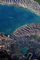
English: This detailed astronaut photograph highlights the southern Mingachevir Reservoir in north-central Azerbaijan. Folded layers of relatively young (less than 5. 3 million years old) sedimentary rock, explosive volcanic products (ash and tuff), and unconsolidated sediments form the grey hills along the northern and southern shorelines of the reservoir (image centre and right). Afternoon sun highlights distinctive parallel patterns in the hills that are the result of water and wind erosion of different rock layers exposed at the surface. The nearby city of Mingachevir (left) is split by the Kur River after it passes through the dam and hydroelectric power station complex at image top centre. The reservoir held approximately 15 billion cubic meters of water at the time this image was taken, with a total engineered capacity of 16 billion cubic meters. The width of the reservoir illustrated here is approximately 8 kilometres; a jet flying over the reservoir left a contrail midway between the shorelines.
Tarix
Mənbə
NASA Earth Observatory
Müəllif
ISS Expedition 23 crew
Camera location
40° 48′ 00″ N, 47° 06′ 00″ E
View this and other nearby images on: OpenStreetMap
40.800000; 47.100000
This image or video was catalogued by Johnson Space Center of the United States National Aeronautics and Space Administration (NASA) under Photo ID: ISS023-E-35670.
This tag does not indicate the copyright status of the attached work. A normal copyright tag is still required.See Commons:Licensing.العربية ∙ беларуская (тарашкевіца) ∙ български ∙ català ∙ čeština ∙ dansk ∙ Deutsch ∙ English ∙ español ∙ فارسی ∙ français ∙ galego ∙ magyar ∙ հայերեն ∙ Bahasa Indonesia ∙ italiano ∙ 日本語 ∙ македонски ∙ മലയാളം ∙ Nederlands ∙ polski ∙ português ∙ русский ∙ sicilianu ∙ Türkçe ∙ українська ∙ 简体中文 ∙ 繁體中文 ∙ +/−
Image captured with a Nikon D3S digital camera, and is provided by the ISS Crew Earth Observations experiment and Image Science & Analysis Laboratory, Johnson Space Center.
Lisenziya
Public domainPublic domainfalsefalse
Annotations
InfoField
This image is annotated: View the annotations at Commons
2841
1462
383
750
4256
2829
Mingachevir Reservoir
3016
394
53
409
4256
2829
contrail
1681
686
218
245
4256
2829
dam
1218
1377
277
340
4256
2829
Mingachevir
287
2196
245
96
4256
2829
Kur River
Captions
Add a one-line explanation of what this file represents
Items portrayed in this file
təsvir edir
copyright status ingilis
ictimai varidat
determination method ingilis: work of the federal government of the United States ingilis
yaranma tarixi
7 iyun 2010
coordinates of the point of view ingilis
40°48'0.000"N, 47°6'0.000"E
captured with ingilis
Nikon D3S ingilis
kataloq kodu
ISS023-E-35670
kataloq: Media catalogue of the Johnson Space Center ingilis
əhəmiyyətli hadisə
Expedition 23 ingilis
Faylın tarixçəsi
Faylın əvvəlki versiyasını görmək üçün gün/tarix bölməsindəki tarixlərə klikləyin.
{{Information |Description={{en|1=This detailed astronaut photograph highlights the southern Mingachevir Reservoir in north-central Azerbaijan. Folded layers of relatively young (less than 5. 3 million years old) sedimentary rock, explosive volcanic p
Bu faylda fotoaparat və ya skanerlə əlavə olunmuş məlumatlar var. Əgər fayl sonradan redaktə olunubsa, bəzi parametrlər bu şəkildə göstərilənlərdən fərqli ola bilər.
Kamera istehsalçısı
NIKON CORPORATION
Kamera modeli
NIKON D3S
Exposure time
1/250 saniyə (0,004)
F nömrəsi
f/9
ISO sürət reytinqi
200
Orijinal tarix və vaxt
13:30, 8 may 2010
Fokus məsafəsi
800 mm
Orientasiya
Normal
Üfüqi xətt
240 dpi
Şaquli xətt
240 dpi
Proqram təminatı
Microsoft Windows Photo Gallery 6.0.6001.18000
Faylın dəyişməsi tarixi və vaxtı
15:48, 7 iyun 2010
Ekspozisiya proqramı
Açıqlıq üstünlüyü
Exif versiyası
2.21
Tarix və vaxt rəqəmləşdirilir
13:30, 8 may 2010
APEX shutter speed
7,965784
Obyektiv gözü
6,33985
APEX exposure bias
0
Maximum land aperture
5 APEX (f/5,66)
Metering mode
Dizaynlı
İşıq mənbəsi
Naməlum
Flaş
Flaş yandırılmadı
İstifadəçi şərhi
NASA#2007934
DateTime subseconds
16
DateTimeOriginal subseconds
16
DateTimeDigitized subseconds
16
Rəng sahəsi
sRGB
Sensing method
Birkristallı matrisli rəngli sensor
Fayl mənbəsi
Rəqəmsal fotoapparat
Səhnə tipi
Foto-təsvir birbaşa çəkilmişdir
Custom image processing
Normal proses
Exposure mode
Avtomatik ekspozisiya
Ağ balansı
Bəyaz balansın avtomatik tənzimlənməsi
Digital zoom ratio
1
Focal length in 35 mm film
800 mm
Scene capture type
Standart
Səhnə idarəsi
Heç biri
Kontrast
Normal
Doymuşluq
Normal
Kəskinlik
Normal
Subject distance range
Naməlum
Yanvar 03, 2023
fayl, mingachevir, reservoir, azerbaijan, fayl, faylın, tarixçəsi, istifadə, edilən, səhifələr, faylın, qlobal, istifadəsi, metaməlumatlarsınaq, göstərişi, ölçüsü, piksel, digər, ölçülər, piksel, piksel, piksel, piksel, piksel, piksel, faylın, orijinalı, 8206,. Fayl Faylin tarixcesi Istifade edilen sehifeler Faylin qlobal istifadesi MetamelumatlarSinaq gosterisi olcusu 398 599 piksel Diger olculer 159 240 piksel 319 480 piksel 510 768 piksel 680 1 024 piksel 1 361 2 048 piksel 2 829 4 256 piksel Faylin orijinali 8206 2 829 4 256 piksel fayl hecmi 2 08 MB MIME novu image jpeg Bu fayl Vikimedia Commons dadirve diger layihelerde istifade edile biler Faylin tesvir sehifesine get Xulase IzahMingachevir Reservoir Azerbaijan JPG English This detailed astronaut photograph highlights the southern Mingachevir Reservoir in north central Azerbaijan Folded layers of relatively young less than 5 3 million years old sedimentary rock explosive volcanic products ash and tuff and unconsolidated sediments form the grey hills along the northern and southern shorelines of the reservoir image centre and right Afternoon sun highlights distinctive parallel patterns in the hills that are the result of water and wind erosion of different rock layers exposed at the surface The nearby city of Mingachevir left is split by the Kur River after it passes through the dam and hydroelectric power station complex at image top centre The reservoir held approximately 15 billion cubic meters of water at the time this image was taken with a total engineered capacity of 16 billion cubic meters The width of the reservoir illustrated here is approximately 8 kilometres a jet flying over the reservoir left a contrail midway between the shorelines Tarix 7 iyun 2010Menbe NASA Earth ObservatoryMuellif ISS Expedition 23 crew Camera location40 48 00 N 47 06 00 E View this and other nearby images on OpenStreetMap40 800000 47 100000This image or video was catalogued by Johnson Space Center of the United States National Aeronautics and Space Administration NASA under Photo ID ISS023 E 35670 This tag does not indicate the copyright status of the attached work A normal copyright tag is still required See Commons Licensing العربية belaruskaya tarashkevica blgarski catala cestina dansk Deutsch English espanol فارسی francais galego magyar հայերեն Bahasa Indonesia italiano 日本語 makedonski മലയ ള Nederlands polski portugues russkij sicilianu Turkce ukrayinska 简体中文 繁體中文 Image captured with a Nikon D3S digital camera and is provided by the ISS Crew Earth Observations experiment and Image Science amp Analysis Laboratory Johnson Space Center Lisenziya Public domain Public domain false falseThis file is in the public domain in the United States because it was solely created by NASA NASA copyright policy states that NASA material is not protected by copyright unless noted See Template PD USGov NASA copyright policy page or JPL Image Use Policy Warnings Use of NASA logos insignia and emblems is restricted per U S law 14 CFR 1221 The NASA website hosts a large number of images from the Soviet Russian space agency and other non American space agencies These are not necessarily in the public domain Materials based on Hubble Space Telescope data may be copyrighted if they are not explicitly produced by the STScI 1 See also PD Hubble and Cc Hubble The SOHO ESA amp NASA joint project implies that all materials created by its probe are copyrighted and require permission for commercial non educational use 2 Images featured on the Astronomy Picture of the Day APOD web site may be copyrighted 3 The National Space Science Data Center NSSDC site has been known to host copyrighted content Its photo gallery FAQ states that all of the images in the photo gallery are in the public domain Unless otherwise noted AnnotationsInfoFieldThis image is annotated View the annotations at Commons2841 1462 383 750 4256 2829 Mingachevir Reservoir 3016 394 53 409 4256 2829 contrail 1681 686 218 245 4256 2829 dam 1218 1377 277 340 4256 2829 Mingachevir 287 2196 245 96 4256 2829 Kur RiverCaptionsazerbaycancaAdd a one line explanation of what this file representsItems portrayed in this filetesvir edircopyright status ingilisictimai varidatdetermination method ingilis work of the federal government of the United States ingilisyaranma tarixi7 iyun 2010coordinates of the point of view ingilis40 48 0 000 N 47 6 0 000 Ecaptured with ingilisNikon D3S ingiliskataloq koduISS023 E 35670kataloq Media catalogue of the Johnson Space Center ingilisehemiyyetli hadiseExpedition 23 ingilis Faylin tarixcesi Faylin evvelki versiyasini gormek ucun gun tarix bolmesindeki tarixlere klikleyin Tarix VaxtKicik sekilOlculerIstifadeciSerh indiki10 00 18 iyun 20182 829 4 256 2 08 MB SteinsplitterBotBot Image rotated by 270 16 54 7 iyun 20104 256 2 829 2 09 MB Originalwana Information Description en 1 This detailed astronaut photograph highlights the southern Mingachevir Reservoir in north central Azerbaijan Folded layers of relatively young less than 5 3 million years old sedimentary rock explosive volcanic p Istifade edilen sehifeler Bu sekile olan kecidler Bozdag silsilesi Mingecevir su anbari Sablon Su anbari Sablon Su anbari doc Faylin qlobal istifadesi Bu fayl asagidaki vikilerde istifade olunur arz wikipedia org layihesinde istifadesi بحيره مينجاتشيڤير ريسيرڤوير azb wikipedia org layihesinde istifadesi مینگه چئویر az wiktionary org layihesinde istifadesi Mingecevir su anbari be wikipedia org layihesinde istifadesi Mingechaurskaya GES Mingechevirskae vadashovishcha ca wikipedia org layihesinde istifadesi Masses d aigua de l Azerbaidjan ceb wikipedia org layihesinde istifadesi Mingechaur Sea cs wikipedia org layihesinde istifadesi Mingacevirska prehradni nadrz de wikipedia org layihesinde istifadesi Mingecevir Stausee en wikipedia org layihesinde istifadesi Mingachevir Bodies of water of Azerbaijan Mingachevir reservoir List of reservoirs by surface area Hydroelectric power stations in Azerbaijan eo wikipedia org layihesinde istifadesi Akvaĵoj en Azerbajĝano Akvobaraĵo Mingacevir es wikipedia org layihesinde istifadesi Azerbaiyan Anexo Embalses del mundo por superficie y volumen de agua fa wikipedia org layihesinde istifadesi مخزن سد مینگه چویر fi wikipedia org layihesinde istifadesi Mingecevirin tekojarvi fr wikipedia org layihesinde istifadesi Reservoir de Mingachevir Barrage de Mingatchevir fy wikipedia org layihesinde istifadesi Wetters yn Azerbeidzjan he wikipedia org layihesinde istifadesi אזרבייג ן תבנית הערים הגדולות של אזרבייג ן hr wikipedia org layihesinde istifadesi Mingecaur Mingecaursko jezero hu wikipedia org layihesinde istifadesi Mingecevir Mingeceviri viztarozo hy wikipedia org layihesinde istifadesi Մինգեչաուրի հիդրոէլեկտրակայան Մինգեչաուրի ջրամբար id wikipedia org layihesinde istifadesi Pembangkit Listrik Tenaga Air Mingachevir ilo wikipedia org layihesinde istifadesi Dagiti bagi ti danum ti Azerbaijan it wikipedia org layihesinde istifadesi Bacino di Mingacevir Bacini dell Azerbaigian ja wikipedia org layihesinde istifadesi アゼルバイジャンの水域 ka wikipedia org layihesinde istifadesi მინგეჩაურის წყალსაცავი აზერბაიჯანის წყალსაცავები ჰიდროელექტროსადგურები აზერბაიჯანში ky wikipedia org layihesinde istifadesi Mingechuar suu saktagychy lt wikipedia org layihesinde istifadesi Mingecevyro tvenkinys ms wikipedia org layihesinde istifadesi Empangan hidroelektrik Mingachevir nl wikipedia org layihesinde istifadesi Mingecevir Waterkrachtcentrale Mingecevir no wikipedia org layihesinde istifadesi Mingetsjevir vannkraftverk pl wikipedia org layihesinde istifadesi Zbiornik Mingeczaurski ru wikipedia org layihesinde istifadesi Mingechevirskoe vodohranilishe sco wikipedia org layihesinde istifadesi Mingachevir Dam simple wikipedia org layihesinde istifadesi Bodies of water of Azerbaijan sv wikipedia org layihesinde istifadesi Mingacevirreservoaren Bu faylin qlobal istifadesine baxin Metamelumatlar Bu faylda fotoaparat ve ya skanerle elave olunmus melumatlar var Eger fayl sonradan redakte olunubsa bezi parametrler bu sekilde gosterilenlerden ferqli ola biler Kamera istehsalcisiNIKON CORPORATIONKamera modeliNIKON D3SExposure time1 250 saniye 0 004 F nomresif 9ISO suret reytinqi200Orijinal tarix ve vaxt13 30 8 may 2010Fokus mesafesi800 mmOrientasiyaNormalUfuqi xett240 dpiSaquli xett240 dpiProqram teminatiMicrosoft Windows Photo Gallery 6 0 6001 18000Faylin deyismesi tarixi ve vaxti15 48 7 iyun 2010Ekspozisiya proqramiAciqliq ustunluyuExif versiyasi2 21Tarix ve vaxt reqemlesdirilir13 30 8 may 2010APEX shutter speed7 965784Obyektiv gozu6 33985APEX exposure bias0Maximum land aperture5 APEX f 5 66 Metering modeDizaynliIsiq menbesiNamelumFlasFlas yandirilmadiIstifadeci serhiNASA 2007934DateTime subseconds16DateTimeOriginal subseconds16DateTimeDigitized subseconds16Reng sahesisRGBSensing methodBirkristalli matrisli rengli sensorFayl menbesiReqemsal fotoapparatSehne tipiFoto tesvir birbasa cekilmisdirCustom image processingNormal prosesExposure modeAvtomatik ekspozisiyaAg balansiBeyaz balansin avtomatik tenzimlenmesiDigital zoom ratio1Focal length in 35 mm film800 mmScene capture typeStandartSehne idaresiHec biriKontrastNormalDoymusluqNormalKeskinlikNormalSubject distance rangeNamelum Menbe https az wikipedia org wiki Fayl Mingachevir Reservoir Azerbaijan JPG, wikipedia, oxu, kitab, kitabxana, axtar, tap, hersey,
ne axtarsan burda
, en yaxsi meqale sayti, meqaleler, kitablar, oyrenmek, wiki, bilgi, tarix, seks, porno, indir, yukle, sex, azeri sex, azeri, seks yukle, sex yukle, izle, seks izle, porno izle, mobil seks, telefon ucun, chat, azeri chat, tanisliq, tanishliq, azeri tanishliq, sayt, medeni, medeni saytlar, chatlar, mekan, tanisliq mekani, mekanlari, yüklə, pulsuz, pulsuz yüklə, mp3, video, mp4, 3gp, jpg, jpeg, gif, png, şəkil, muisiqi, mahnı, kino, film, kitab, oyun, oyunlar.