Bu fayl "Vikimedia Commons"dadır və digər layihələrdə istifadə edilə bilər.
Faylın təsvir səhifəsinə get
Xülasə
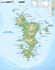
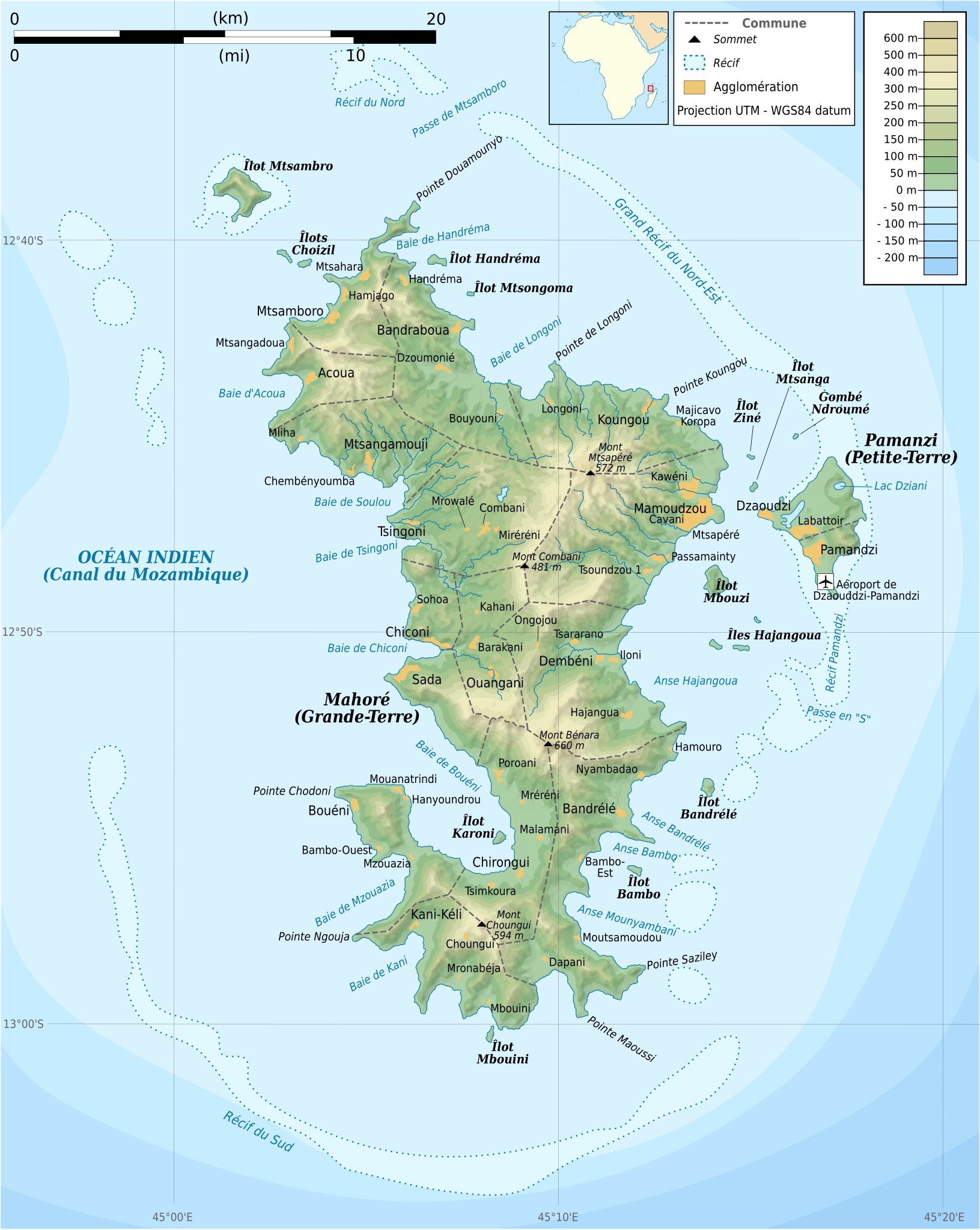
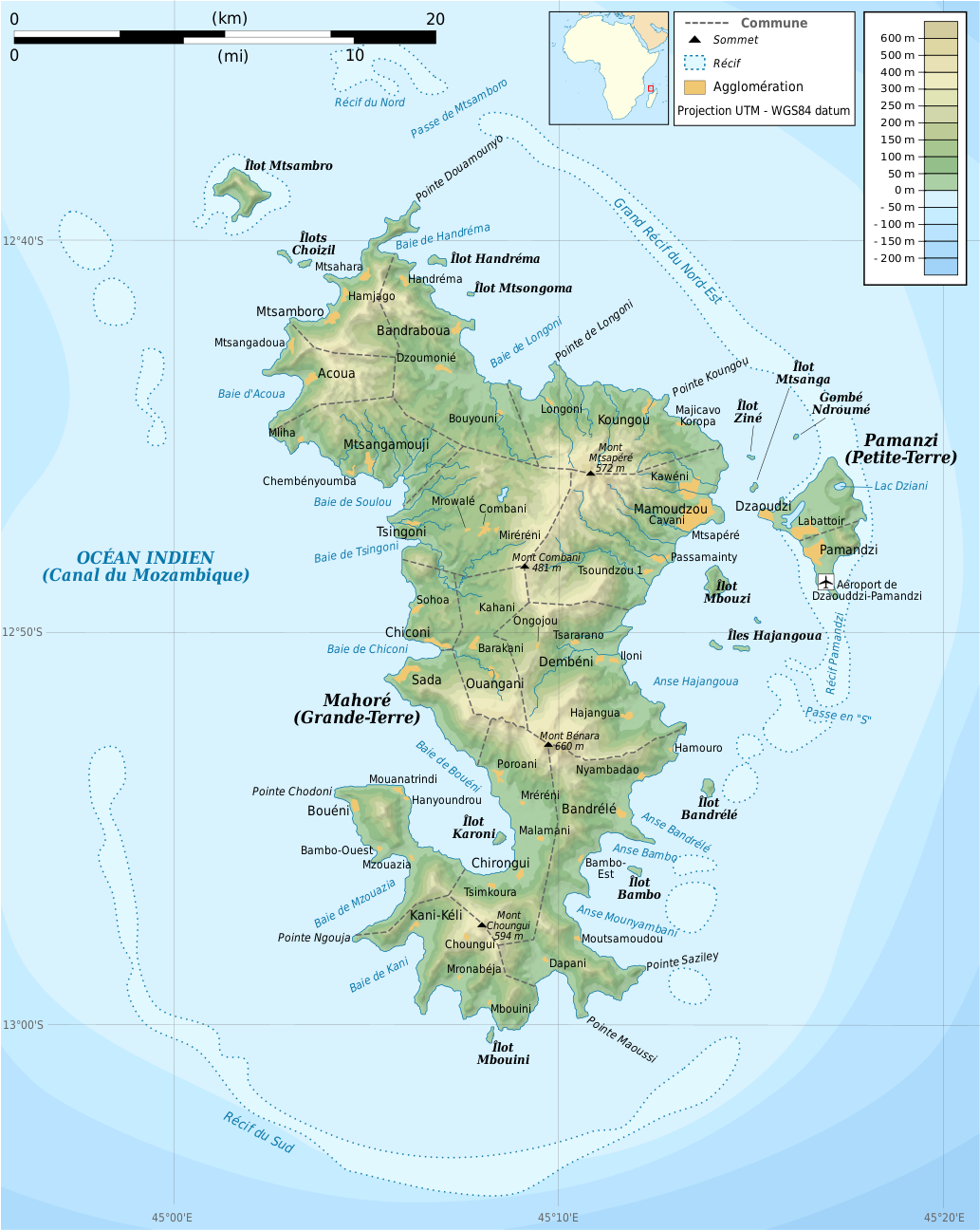
İzahMayotte topographic map-fr.svg
English: Topographic map of Mayotte in French. Use the PNG version in articles for faster loading.
Français : Carte topographique de Mayotte en français. Utiliser la version PNG dans les articles pour un rendu plus rapide.
UTM projection, WGS84 datum
The shaded relief is an embedded raster image, delete it to make the file smaller.
Tarix
Mənbə
Own work. Sources of data:
NASA SRTM3 for terrain (public domain);
NASA SWBD for coastlines and lakes
NGDC ETOPO1 for bathymetry (public domain);
VMap-0 for miscellaneous data (public domain);
Maps of Mayotte from Malango and Géoportail for checking accuracy and names.
Locator map: adapted from File:Africa map blank.svg by User:Sting.
Created using this tutorial by User:Sting.
Müəllif
Rémi Kaupp
Digər versiyalar
[redaktə]
Topographic, French, SVG (PNG version)
Topographic, blank, SVG (PNG version)
Road map, French, SVG (PNG version)
Administrative, French, SVG (PNG version)
Communes, French, SVG (PNG version)
Blank, SVG
Bu xəritə Qrafik emalatxanada (fr) yaradılmışdır. Siz həmçinin təsvirin yaxşılaşması ilə bağlı müraciət edə bilərsiniz.
English: This map has been created by Rémi Kaupp (User:Korrigan) and released under the license(s) stated below. You are free to use it for any purpose as long as you credit me and follow the terms of the license. You may need to credit the sources of data of the map (please check). Example:
Français : Cette carte a été créée par Rémi Kaupp (User:Korrigan) et placée sous la ou les licence(s) ci-dessous. Vous êtes libre de la réutiliser, tant que vous me citez en tant qu'auteur et suivez les instructions de la licence. Certaines sources de données de la carte doivent peut-être être créditées, veuillez vérifier. Exemple :
I, the copyright holder of this work, hereby publish it under the following licenses:
Bu sənədi GNU Azad Sənədləşdirmə Lisenziyası, Versiya 1.2 və ya Azad Proqram Fondu tərəfindən nəşr olunan hər hansı sonrakı versiya şərtlərinə əsasən dəyişməz bölmələr, ön qapaq mətnləri və arxa qapaq mətnləri olmadan köçürmək, yayımlamaq və / və ya dəyişdirmək üçün icazə verilir; Lisenziyanın bir nüsxəsi GNU Azad Sənədləşdirmə Lisenziyası adlı hissəyə daxil edilmişdir.http://www.gnu.org/copyleft/fdl.htmlGFDLGNU Free Documentation Licensetruetrue
This file is licensed under the Creative Commons Attribution-Share Alike 4.0 International, 3.0 Unported, 2.5 Generic, 2.0 Generic and 1.0 Generic license.
Azadsınız:
paylaşmaq – əsəri köçürmək, paylamaq və ötürmək üçün
remiks etmək – əsəri adaptasiya etmək
Aşağıdakı şərtlərə riayət etməklə:
istinad – Müvafiq kredit verməlisiniz, lisenziyaya bir keçid verməlisiniz və dəyişikliklərin olub olmadığını bildirməlisiniz. Bunu hər hansı bir ağlabatan şəkildə edə bilərsiniz, ancaq lisenziyalaşdırıcının sizi və ya istifadənizi təsdiqləməsini təklif edən bir şəkildə deyil.
bənzər paylaşma – Əsəri remix edirsinizsə, dəyişdirirsinizsə və ya üzərində iş aparırsınızsa, öz töhfələrinizi orijinalda olduğu kimi eyni və ya uyğun lisenziya altında yayımlamalısınız.
{{Information |Description={{en|Topographic map of Mayotte in French. Use the PNG version in articles for faster loading.}} {{fr|Carte topographique de Mayotte en français. Utiliser [[:File:Mayotte_topographic
Mlima Combani and Mlima Mtsapéré Important Bird Area
Grande-Terre (Mayotte)
Projet:Cartographie/Cartes standards/France
Géographie de Mayotte
Liste des îles de Mayotte
Utilisateur:Exp JC/Brouillon
Majotta
Майот
마요트
Μαγιότ
مايوت
Majoto
Майотта
May 12, 2023
fayl, mayotte, topographic, fayl, faylın, tarixçəsi, fayl, keçidləri, faylın, qlobal, istifadəsibu, faylın, formatındakı, görünüşünün, ölçüsü, piksel, digər, ölçülər, piksel, piksel, piksel, piksel, piksel, piksel, faylın, orijinalı, 8206, faylı, nominal, olar. Fayl Faylin tarixcesi Fayl kecidleri Faylin qlobal istifadesiBu SVG faylin PNG formatindaki bu gorunusunun olcusu 477 599 piksel Diger olculer 191 240 piksel 382 480 piksel 612 768 piksel 815 1 024 piksel 1 631 2 048 piksel 1 033 1 297 piksel Faylin orijinali 8206 SVG fayli nominal olaraq 1 033 1 297 piksel faylin olcusu 874 KB Bu fayl Vikimedia Commons dadirve diger layihelerde istifade edile biler Faylin tesvir sehifesine get Xulase IzahMayotte topographic map fr svg English Topographic map of Mayotte in French Use the PNG version in articles for faster loading Francais nbsp Carte topographique de Mayotte en francais Utiliser la version PNG dans les articles pour un rendu plus rapide UTM projection WGS84 datum The shaded relief is an embedded raster image delete it to make the file smaller Tarix 24 mart 2009 Menbe Own work Sources of data NASA SRTM3 for terrain public domain NASA SWBD for coastlines and lakes NGDC ETOPO1 for bathymetry public domain VMap 0 for miscellaneous data public domain Maps of Mayotte from Malango and Geoportail for checking accuracy and names Locator map adapted from File Africa map blank svg by User Sting Created using this tutorial by User Sting Muellif Remi Kaupp Diger versiyalar redakte Topographic French SVG PNG version Topographic blank SVG PNG version Road map French SVG PNG version Administrative French SVG PNG version Communes French SVG PNG version Blank SVG Bu xerite Qrafik emalatxanada fr yaradilmisdir Siz hemcinin tesvirin yaxsilasmasi ile bagli muraciet ede bilersiniz English This map has been created by Remi Kaupp User Korrigan and released under the license s stated below You are free to use it for any purpose as long as you credit me and follow the terms of the license You may need to credit the sources of data of the map please check Example Francais nbsp Cette carte a ete creee par Remi Kaupp User Korrigan et placee sous la ou les licence s ci dessous Vous etes libre de la reutiliser tant que vous me citez en tant qu auteur et suivez les instructions de la licence Certaines sources de donnees de la carte doivent peut etre etre creditees veuillez verifier Exemple nbsp c Remi Kaupp CC BY SA Wikimedia Commons Lisenziya I the copyright holder of this work hereby publish it under the following licenses Bu senedi GNU Azad Senedlesdirme Lisenziyasi Versiya 1 2 ve ya Azad Proqram Fondu terefinden nesr olunan her hansi sonraki versiya sertlerine esasen deyismez bolmeler on qapaq metnleri ve arxa qapaq metnleri olmadan kocurmek yayimlamaq ve ve ya deyisdirmek ucun icaze verilir Lisenziyanin bir nusxesi GNU Azad Senedlesdirme Lisenziyasi adli hisseye daxil edilmisdir http www gnu org copyleft fdl html GFDL GNU Free Documentation License true trueThis file is licensed under the Creative Commons Attribution Share Alike 4 0 International 3 0 Unported 2 5 Generic 2 0 Generic and 1 0 Generic license Azadsiniz paylasmaq eseri kocurmek paylamaq ve oturmek ucun remiks etmek eseri adaptasiya etmek Asagidaki sertlere riayet etmekle istinad Muvafiq kredit vermelisiniz lisenziyaya bir kecid vermelisiniz ve deyisikliklerin olub olmadigini bildirmelisiniz Bunu her hansi bir aglabatan sekilde ede bilersiniz ancaq lisenziyalasdiricinin sizi ve ya istifadenizi tesdiqlemesini teklif eden bir sekilde deyil benzer paylasma Eseri remix edirsinizse deyisdirirsinizse ve ya uzerinde is aparirsinizsa oz tohfelerinizi orijinalda oldugu kimi eyni ve ya uygun lisenziya altinda yayimlamalisiniz https creativecommons org licenses by sa 4 0 CC BY SA 4 0 Creative Commons Attribution Share Alike 4 0 true trueIstediyiniz lisenziyani sece bilersiniz CaptionsazerbaycancaAdd a one line explanation of what this file representsingilisMayotte topographic map by Remi KauppItems portrayed in this filetesvir ediryaradiciSome value without a Vikiverilenler itemWikimedia username nbsp ingilis Korriganmuellifin qisa adi Remi KauppURL nbsp ingilis https commons wikimedia org wiki user Korrigancopyright status nbsp ingiliscopyrighted nbsp ingilislisenziyaCreative Commons Attribution ShareAlike 1 0 Generic nbsp ingilisCreative Commons Attribution ShareAlike 2 0 Generic nbsp ingilisGNU Free Documentation License version 1 2 or later nbsp ingilisCreative Commons Attribution ShareAlike 2 5 Generic nbsp ingilisCreative Commons Attribution ShareAlike 4 0 International nbsp ingilisCreative Commons Attribution ShareAlike 3 0 Unported nbsp ingilisyaranma tarixi24 mart 2009 Faylin tarixcesi Faylin evvelki versiyasini gormek ucun gun tarix bolmesindeki tarixlere klikleyin Tarix VaxtKicik sekilOlculerIstifadeciSerh indiki20 55 24 mart 20091 033 1 297 874 KB Korrigan Information Description en Topographic map of Mayotte in French Use the PNG version in articles for faster loading fr Carte topographique de Mayotte en francais Utiliser File Mayotte topographic Fayl kecidleri Bu sekile olan kecidler Mayotta Mayotta adasi Faylin qlobal istifadesi Bu fayl asagidaki vikilerde istifade olunur ar wikipedia org layihesinde istifadesi مايوت bar wikipedia org layihesinde istifadesi Mayotte br wikipedia org layihesinde istifadesi Mayotte ca wikipedia org layihesinde istifadesi Mayotte ce wikipedia org layihesinde istifadesi Majotta cs wikipedia org layihesinde istifadesi Mayotte en wikipedia org layihesinde istifadesi Mayotte Geography of Mayotte Baie de Boueni Hachiroungou Important Bird Area Mlima Combani and Mlima Mtsapere Important Bird Area es wikipedia org layihesinde istifadesi Geografia de Mayotte fr wikipedia org layihesinde istifadesi Mayotte Grande Terre Mayotte Projet Cartographie Cartes standards France Geographie de Mayotte Liste des iles de Mayotte Utilisateur Exp JC Brouillon ga wikipedia org layihesinde istifadesi Mayotte gl wikipedia org layihesinde istifadesi Mayotte io wikipedia org layihesinde istifadesi Mayotte is wikipedia org layihesinde istifadesi Mayotte it wikipedia org layihesinde istifadesi Mayotte la wikipedia org layihesinde istifadesi Maiota nl wikipedia org layihesinde istifadesi Mayotte pl wiktionary org layihesinde istifadesi Mayotte Majotta Majot 마요트 Magiot مايوت Majoto Majotta ru wikipedia org layihesinde istifadesi Spisok mlekopitayushih Majotty sc wikipedia org layihesinde istifadesi Mayotte tt wikipedia org layihesinde istifadesi Majotta uk wikipedia org layihesinde istifadesi Spisok ssavciv Majotti www wikidata org layihesinde istifadesi Q17063 Menbe https az wikipedia org wiki Fayl Mayotte topographic map fr svg, wikipedia, oxu, kitab, kitabxana, axtar, tap, hersey,
ne axtarsan burda
, en yaxsi meqale sayti, meqaleler, kitablar, oyrenmek, wiki, bilgi, tarix, seks, porno, indir, yukle, sex, azeri sex, azeri, seks yukle, sex yukle, izle, seks izle, porno izle, mobil seks, telefon ucun, chat, azeri chat, tanisliq, tanishliq, azeri tanishliq, sayt, medeni, medeni saytlar, chatlar, mekan, tanisliq mekani, mekanlari, yüklə, pulsuz, pulsuz yüklə, mp3, video, mp4, 3gp, jpg, jpeg, gif, png, şəkil, muisiqi, mahnı, kino, film, kitab, oyun, oyunlar.