Bu fayl "Vikimedia Commons"dadır və digər layihələrdə istifadə edilə bilər.
Faylın təsvir səhifəsinə get
This map image could be re-created using vector graphics as an SVG file. This has several advantages; see Commons:Media for cleanup for more information. If an SVG form of this image is available, please upload it and afterwards replace this template with {{vector version available|new image name}}. It is recommended to name the SVG file "Map of the Holy Roman Empire, 1789 en.svg" – then the template Vector version available (or Vva) does not need the new image name parameter.
Xülasə
DescriptionMap of the Holy Roman Empire, 1789 en.png
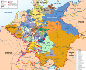
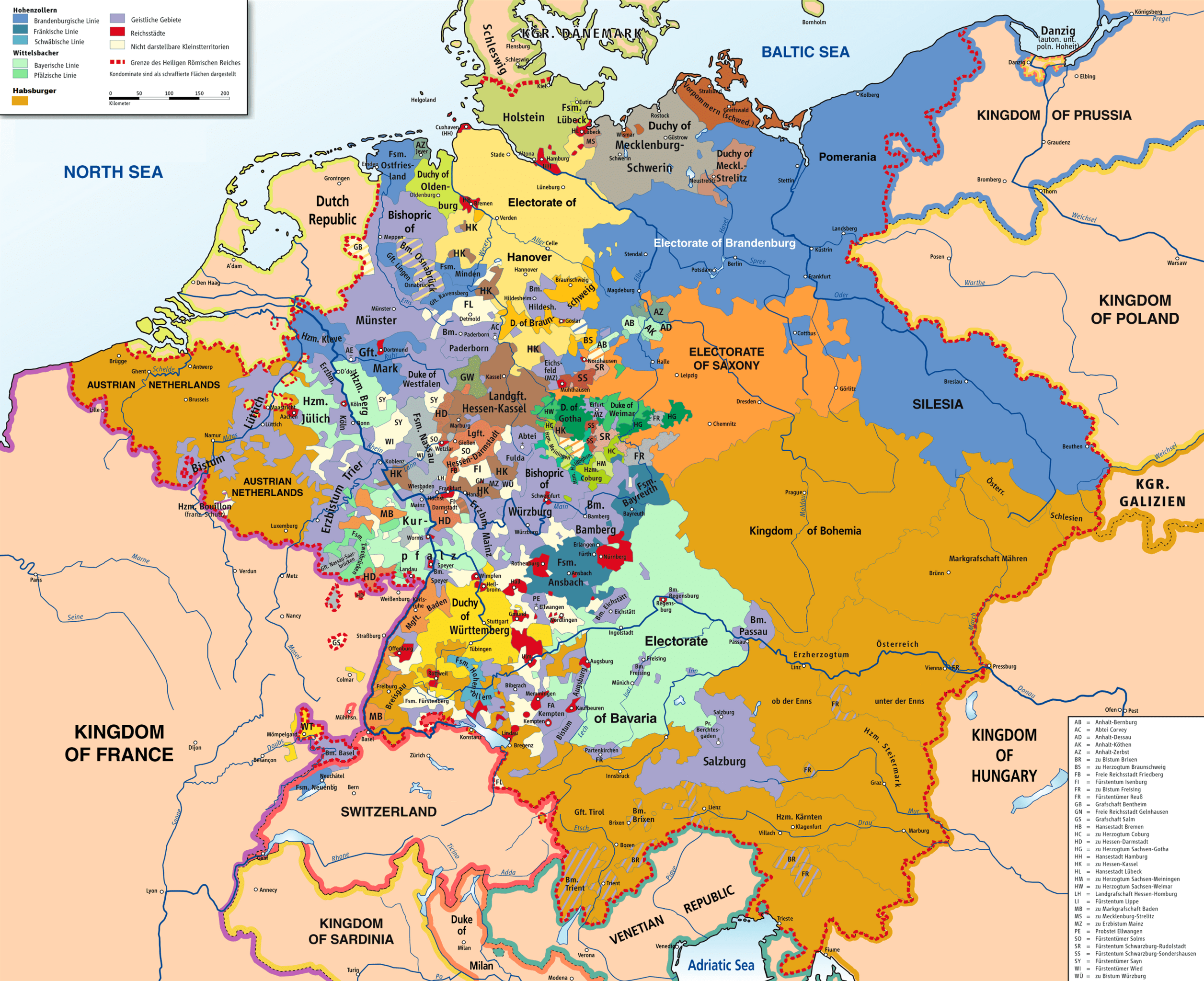
English: Map of the Holy Roman Empire, 1789.
Tarix
Mənbə
Own work based on: HRR 1789.png "translated (somewhat) from original German version"
References:
Putzger, F. W. (1965) Historischer Weltatlas (89. ed.)
(1969) Westermanns Großer Atlas zur Weltgeschichte, Georg Westermann Verlag
Haacks geographischer Atlas. VEB Hermann Haack Geographisch-Kartographische Anstalt, Gotha/Leipzig, 1. Auflage, 1979
Kinder, Hermann (1989) Dtv-Atlas Weltgeschichte / 2, Von der Französischen Revolution bis zur Gegenwart. (23. ed.), Münhen: Dt. Taschenbuch-Verl ISBN: 3-423-03002-X. OCLC: 313766861.
Yaradıcı
Robert Alfers, ziegelbrenner
Georeferencing
Georeference the map in Wikimaps Warper If inappropriate please set warp_status = skip to hide.
Digər versiyalar
German original
Lisenziya
This file is licensed under the Creative Commons Attribution-Share Alike 3.0 Unported, 2.5 Generic, 2.0 Generic and 1.0 Generic license.
Azadsınız:
paylaşmaq – əsəri köçürmək, paylamaq və ötürmək üçün
remiks etmək – əsəri adaptasiya etmək
Aşağıdakı şərtlərə riayət etməklə:
istinad – Müvafiq kredit verməlisiniz, lisenziyaya bir keçid verməlisiniz və dəyişikliklərin olub olmadığını bildirməlisiniz. Bunu hər hansı bir ağlabatan şəkildə edə bilərsiniz, ancaq lisenziyalaşdırıcının sizi və ya istifadənizi təsdiqləməsini təklif edən bir şəkildə deyil.
bənzər paylaşma – Əsəri remix edirsinizsə, dəyişdirirsinizsə və ya üzərində iş aparırsınızsa, öz töhfələrinizi orijinalda olduğu kimi eyni və ya uyğun lisenziya altında yayımlamalısınız.
I've added a few more English place names, as follows: Wien > Vienna Muenchen > Munich Mailand > Milan Bruessel > Brussels Prag > Prague Antwerpen > Antwerp Triest > Trieste Warschau > Warsaw Gent > Ghent Erzbistum removed from Salzburg; should be Ar...
{{Information |Description={{en|1=Map of the Holy Roman Empire, 1789, translated (somewhat) from original German version on Wikipedia Commons}} |Source=Own source, translated map from Image:HRR 1789.png, also on WC |Author=Robert Alfers, [[:de:Benutzer:kg
fayl, holy, roman, empire, 1789, fayl, faylın, tarixçəsi, fayl, keçidləri, faylın, qlobal, istifadəsisınaq, göstərişi, ölçüsü, piksel, digər, ölçülər, piksel, piksel, piksel, piksel, piksel, piksel, faylın, orijinalı, 8206, piksel, fayl, həcmi, mime, növü, ima. Fayl Faylin tarixcesi Fayl kecidleri Faylin qlobal istifadesiSinaq gosterisi olcusu 736 600 piksel Diger olculer 295 240 piksel 589 480 piksel 942 768 piksel 1 256 1 024 piksel 2 513 2 048 piksel 2 650 2 160 piksel Faylin orijinali 8206 2 650 2 160 piksel fayl hecmi 726 KB MIME novu image png Bu fayl Vikimedia Commons dadirve diger layihelerde istifade edile biler Faylin tesvir sehifesine get This map image could be re created using vector graphics as an SVG file This has several advantages see nbsp Commons Media for cleanup for more information If nbsp an nbsp SVG nbsp form nbsp of nbsp this nbsp image is available please upload it and afterwards replace this template with vector version available i new image name i It is recommended to name the SVG file Map of the Holy Roman Empire 1789 en svg then the template Vector version available or Vva does not need the new image name parameter Xulase DescriptionMap of the Holy Roman Empire 1789 en png English Map of the Holy Roman Empire 1789 Tarix 8 iyun 2008 Menbe Own work based on HRR 1789 png translated somewhat from original German version References Putzger F W 1965 Historischer Weltatlas 89 ed 1969 Westermanns Grosser Atlas zur Weltgeschichte Georg Westermann Verlag Haacks geographischer Atlas VEB Hermann Haack Geographisch Kartographische Anstalt Gotha Leipzig 1 Auflage 1979 Kinder Hermann 1989 Dtv Atlas Weltgeschichte 2 Von der Franzosischen Revolution bis zur Gegenwart 23 ed Munhen Dt Taschenbuch Verl ISBN 3 423 03002 X OCLC 313766861 Yaradici Robert Alfers ziegelbrenner Georeferencing Georeference the map in Wikimaps Warper If inappropriate please set warp status skip to hide Diger versiyalar German original Lisenziya This file is licensed under the Creative Commons Attribution Share Alike 3 0 Unported 2 5 Generic 2 0 Generic and 1 0 Generic license Azadsiniz paylasmaq eseri kocurmek paylamaq ve oturmek ucun remiks etmek eseri adaptasiya etmek Asagidaki sertlere riayet etmekle istinad Muvafiq kredit vermelisiniz lisenziyaya bir kecid vermelisiniz ve deyisikliklerin olub olmadigini bildirmelisiniz Bunu her hansi bir aglabatan sekilde ede bilersiniz ancaq lisenziyalasdiricinin sizi ve ya istifadenizi tesdiqlemesini teklif eden bir sekilde deyil benzer paylasma Eseri remix edirsinizse deyisdirirsinizse ve ya uzerinde is aparirsinizsa oz tohfelerinizi orijinalda oldugu kimi eyni ve ya uygun lisenziya altinda yayimlamalisiniz https creativecommons org licenses by sa 3 0 CC BY SA 3 0 Creative Commons Attribution Share Alike 3 0 true trueCaptionsazerbaycancaAdd a one line explanation of what this file representsItems portrayed in this filetesvir edircopyright status nbsp ingiliscopyrighted nbsp ingilislisenziyaCreative Commons Attribution ShareAlike 3 0 Unported nbsp ingilisCreative Commons Attribution ShareAlike 2 0 Generic nbsp ingilisCreative Commons Attribution ShareAlike 2 5 Generic nbsp ingilisCreative Commons Attribution ShareAlike 1 0 Generic nbsp ingilisyaranma tarixi8 iyun 2008 Faylin tarixcesi Faylin evvelki versiyasini gormek ucun gun tarix bolmesindeki tarixlere klikleyin Tarix VaxtKicik sekilOlculerIstifadeciSerh indiki14 47 30 noyabr 20182 650 2 160 726 KB FDRMRZUSAImplemented map legend inserted Kilometers 22 59 29 noyabr 20182 650 2 160 810 KB FDRMRZUSAImplemented map legend Habsburger Reduced dimensions size 16 17 17 fevral 20132 650 2 160 2 69 MB Opus33I 039 ve added a few more English place names as follows Wien gt Vienna Muenchen gt Munich Mailand gt Milan Bruessel gt Brussels Prag gt Prague Antwerpen gt Antwerp Triest gt Trieste Warschau gt Warsaw Gent gt Ghent Erzbistum removed from Salzburg should be Ar 17 08 2 iyul 20102 650 2 160 2 55 MB Ras67cropped 04 09 8 iyun 20082 659 2 170 2 62 MB RobNS Information Description en 1 Map of the Holy Roman Empire 1789 translated somewhat from original German version on Wikipedia Commons Source Own source translated map from Image HRR 1789 png also on WC Author Robert Alfers de Benutzer kg Fayl kecidleri Bu sekile olan kecidler Almaniyanin birlesdirilmesi 1871 Faylin qlobal istifadesi Bu fayl asagidaki vikilerde istifade olunur als wikipedia org layihesinde istifadesi Reichsunmittelbarkeit ar wikipedia org layihesinde istifadesi الإمبراطورية الفورية الوساطة الألمانية كلاينشتاتراي azb wikipedia org layihesinde istifadesi موقدس روم ژرمن ایمپراتورلوغو be wikipedia org layihesinde istifadesi Svyashchennaya Rymskaya imperyya Germanskaya medyyatyzacyya bg wikipedia org layihesinde istifadesi Germanska mediatizaciya cs wikipedia org layihesinde istifadesi Svata rise rimska Sjednoceni Nemecka Mediatizace da wikipedia org layihesinde istifadesi Fyrstbispedommet Bamberg de wikipedia org layihesinde istifadesi Diskussion Konigreich Preussen Archiv 1 el wikipedia org layihesinde istifadesi Agia Rwmaikh Aytokratoria en wikipedia org layihesinde istifadesi Holy Roman Empire Battle of Rastatt 1796 Imperial immediacy Unification of Germany German mediatisation Kleinstaaterei Names of Germany Army of Sambre and Meuse Talk Holy Roman Empire Archive 1 Austria Germany relations Siege of Kehl 1796 1797 Wikipedia Graphics Lab Map workshop Archive Dec 2012 Nationality of Wolfgang Amadeus Mozart Rhine campaign of 1796 User Dainomite sandbox Dissolution of the Holy Roman Empire Rhine campaign of 1795 Battle of Kehl 1796 Siege of Huningen 1796 1797 Wikipedia Village pump technical Archive 144 Early clashes in the Rhine campaign of 1796 User Falcaorib User Bunhouse768 sandbox es wikipedia org layihesinde istifadesi Sacro Imperio Romano Germanico Mediatizacion y secularizacion Kleinstaaterei Francisco Alejandro Nebel Disolucion del Sacro Imperio Romano Germanico Relaciones Alemania Austria et wikipedia org layihesinde istifadesi Kleinstaaterei Saksamaa mediatisatsioon gl wikipedia org layihesinde istifadesi Mediatizacion e secularizacion Kleinstaaterei he wikipedia org layihesinde istifadesi יחסי אוסטריה גרמניה hy wikipedia org layihesinde istifadesi Սրբազան Հռոմեական կայսրություն id wikipedia org layihesinde istifadesi Penyatuan Jerman Bu faylin qlobal istifadesine baxin Menbe https az wikipedia org wiki Fayl Map of the Holy Roman Empire 1789 en png, wikipedia, oxu, kitab, kitabxana, axtar, tap, hersey,
ne axtarsan burda
, en yaxsi meqale sayti, meqaleler, kitablar, oyrenmek, wiki, bilgi, tarix, seks, porno, indir, yukle, sex, azeri sex, azeri, seks yukle, sex yukle, izle, seks izle, porno izle, mobil seks, telefon ucun, chat, azeri chat, tanisliq, tanishliq, azeri tanishliq, sayt, medeni, medeni saytlar, chatlar, mekan, tanisliq mekani, mekanlari, yüklə, pulsuz, pulsuz yüklə, mp3, video, mp4, 3gp, jpg, jpeg, gif, png, şəkil, muisiqi, mahnı, kino, film, kitab, oyun, oyunlar.