Bu fayl "Vikimedia Commons"dadır və digər layihələrdə istifadə edilə bilər.
təsvir səhifəsi
Faylın təsvir səhifəsinə get
Xülasə
İzahMap of Sendai Earthquake 2011.jpg
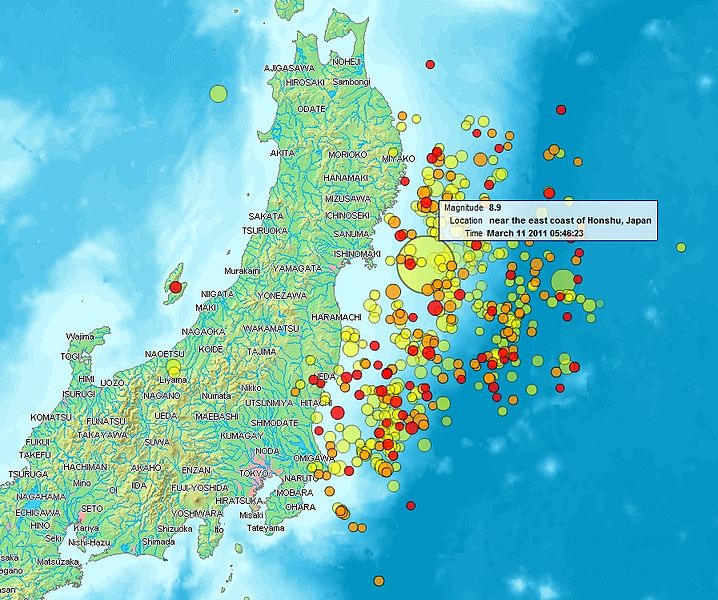
English: Map of the Sendai Earthquake 2011 and aftershocks until March 14, 2011 at 11:20. The size of the circles is a function of magnitude, and the color indicates the date: light green: March 11; yellow: March 12; orange: March 13; red: March 14.
Français : Carte des épicentres et de l'intensité des secousses du tremblement de terre de Sendai du 14 mars 2011. La taille des cercles est fonction de la magnitude, leur couleur indique la date : vert clair, 11.3.2011 ; jaune, 12.3.2011 ; orange, 13.3.2011 ; rouge 14.3.2011.
https://creativecommons.org/publicdomain/mark/1.0/PDMCreative Commons Public Domain Mark 1.0falsefalse
Lisenziya
Public domainPublic domainfalsefalse
Public domainPublic domainfalsefalse
I, the copyright holder of this work, hereby publish it under the following license:
This file is made available under the Creative Commons CC0 1.0 Universal Public Domain Dedication.
The person who associated a work with this deed has dedicated the work to the public domain by waiving all of their rights to the work worldwide under copyright law, including all related and neighboring rights, to the extent allowed by law. You can copy, modify, distribute and perform the work, even for commercial purposes, all without asking permission.
http://creativecommons.org/publicdomain/zero/1.0/deed.enCC0Creative Commons Zero, Public Domain Dedicationfalsefalse
Captions
Add a one-line explanation of what this file represents
Items portrayed in this file
təsvir edir
copyright status ingilis
copyrighted, dedicated to the public domain by copyright holder ingilis
lisenziya
released into the public domain by the copyright holder ingilis
Creative Commons CC0 License ingilis
yaranma tarixi
12 mart 2011
Faylın tarixçəsi
Faylın əvvəlki versiyasını görmək üçün gün/tarix bölməsindəki tarixlərə klikləyin.
{{Information |Description ={{en|1=Map of the Senadai Earthquake 2011}} |Source =http://www2.demis.nl/quakes/ |Author =www2.demis.nl |Date =2011-03-11 |Permission = |other_versions = }} Public domain according to http://ww
Bu faylda fotoaparat və ya skanerlə əlavə olunmuş məlumatlar var. Əgər fayl sonradan redaktə olunubsa, bəzi parametrlər bu şəkildə göstərilənlərdən fərqli ola bilər.
_error
0
Noyabr 05, 2023
fayl, sendai, earthquake, 2011, fayl, faylın, tarixçəsi, fayl, keçidləri, faylın, qlobal, istifadəsi, metaməlumatlarsınaq, göstərişi, ölçüsü, piksel, digər, ölçülər, piksel, piksel, piksel, faylın, orijinalı, 8206, piksel, fayl, həcmi, mime, növü, image, jpeg,. Fayl Faylin tarixcesi Fayl kecidleri Faylin qlobal istifadesi MetamelumatlarSinaq gosterisi olcusu 718 600 piksel Diger olculer 288 240 piksel 575 480 piksel 897 749 piksel Faylin orijinali 8206 897 749 piksel fayl hecmi 606 KB MIME novu image jpeg Bu fayl Vikimedia Commons dadirve diger layihelerde istifade edile biler tesvir sehifesi Faylin tesvir sehifesine get Xulase IzahMap of Sendai Earthquake 2011 jpg English Map of the Sendai Earthquake 2011 and aftershocks until March 14 2011 at 11 20 The size of the circles is a function of magnitude and the color indicates the date light green March 11 yellow March 12 orange March 13 red March 14 Francais nbsp Carte des epicentres et de l intensite des secousses du tremblement de terre de Sendai du 14 mars 2011 La taille des cercles est fonction de la magnitude leur couleur indique la date nbsp vert clair 11 3 2011 nbsp jaune 12 3 2011 nbsp orange 13 3 2011 nbsp rouge 14 3 2011 日本語 2011年3月11日に発生した東北地方太平洋沖地震 および同14日11時20分までの余震を示した地図 円はマグニチュード 色は発生した日付 黄緑 3月11日 黄 3月12日 橙 3月13日 赤 3月14日 を示す Tarix 12 mart 2011 Menbe http www2 demis nl quakes Muellif www2 demis nl Uploader User Heinz Josef Lucking Icaze Faylin tekrar istifadesi Public domain according to http www2 demis nl Public domain Public domain false false This work is in the public domain in its country of origin and other countries and areas where the copyright term is the author s life plus 70 years or fewer You must also include a United States public domain tag to indicate why this work is in the public domain in the United States nbsp Note that a few countries have copyright terms longer than 70 years Mexico has 100 years Jamaica has 95 years Colombia has 80 years and Guatemala and Samoa have 75 years This image may not be in the public domain in these countries which moreover do not implement the rule of the shorter term Honduras has a general copyright term of 75 years but it does implement the rule of the shorter term Copyright may extend on works created by French who died for France in World War II more information Russians who served in the Eastern Front of World War II known as the Great Patriotic War in Russia and posthumously rehabilitated victims of Soviet repressions more information This file has been identified as being free of known restrictions under copyright law including all related and neighboring rights https creativecommons org publicdomain mark 1 0 PDM Creative Commons Public Domain Mark 1 0 false falseLisenziya Public domain Public domain false false This image is in the public domain because it came from the site https www demis nl products web map server examples and was released by the copyright holder Permission is granted to copy distribute and or modify this map since it is based on free of copyright images from www demis nl See also approval email on de wp and its clarification Deutsch nbsp English nbsp makedonski nbsp മലയ ള nbsp Nederlands nbsp slovenscina nbsp Public domain Public domain false false This work has been released into the public domain by its copyright holder www demis nl This applies worldwide In some countries this may not be legally possible if so www demis nl grants anyone the right to use this work for any purpose without any conditions unless such conditions are required by law Public domain Public domain false false I the copyright holder of this work hereby publish it under the following license nbsp This file is made available under the Creative Commons CC0 1 0 Universal Public Domain Dedication The person who associated a work with this deed has dedicated the work to the public domain by waiving all of their rights to the work worldwide under copyright law including all related and neighboring rights to the extent allowed by law You can copy modify distribute and perform the work even for commercial purposes all without asking permission http creativecommons org publicdomain zero 1 0 deed en CC0 Creative Commons Zero Public Domain Dedication false falseCaptionsazerbaycancaAdd a one line explanation of what this file representsItems portrayed in this filetesvir edircopyright status nbsp ingiliscopyrighted dedicated to the public domain by copyright holder nbsp ingilislisenziyareleased into the public domain by the copyright holder nbsp ingilisCreative Commons CC0 License nbsp ingilisyaranma tarixi12 mart 2011 Faylin tarixcesi Faylin evvelki versiyasini gormek ucun gun tarix bolmesindeki tarixlere klikleyin Tarix VaxtKicik sekilOlculerIstifadeciSerh indiki21 31 14 mart 2011897 749 606 KB Heinz Josef Lucking14 3 legend description 04 27 13 mart 20111 362 1 386 1 41 MB Stanqo4h05m UTC 13 03 2011 11 10 12 mart 20111 197 1 245 885 KB Yumahigher resol 10 27 12 mart 2011928 694 470 KB Yumaupdate 17 20 11 mart 20111 006 773 596 KB Heinz Josef Luckingactual 2011 03 11 18 20 11 19 11 mart 20111 014 779 598 KB Erdbeben20110311actuality 09 39 11 mart 20111 009 683 522 KB Erdbeben20110311 Information Description en 1 Map of the Senadai Earthquake 2011 Source http www2 demis nl quakes Author www2 demis nl Date 2011 03 11 Permission other versions Public domain according to http ww Fayl kecidleri Bu sekile olan kecidler Senday zelzelesi ve sunami 2011 Faylin qlobal istifadesi Bu fayl asagidaki vikilerde istifade olunur af wikipedia org layihesinde istifadesi Tōhoku aardbewing en tsoenami van 2011 als wikipedia org layihesinde istifadesi Tōhoku Erdbeben 2011 ar wikipedia org layihesinde istifadesi زلزال وتسونامي توهوكو 2011 ast wikipedia org layihesinde istifadesi Terremotu y tsunami de Xapon de 2011 bat smg wikipedia org layihesinde istifadesi 2011 metu Sendaje zemes kostiejems e cunamis bcl wikipedia org layihesinde istifadesi Linog asin Dolnop sa Tōhoku 2011 be tarask wikipedia org layihesinde istifadesi Zemlyatrus u Yaponii 2011 be wikipedia org layihesinde istifadesi Zemletrasenne y Yaponii 2011 ca wikipedia org layihesinde istifadesi Terratremol i tsunami del Japo del 2011 Plantilla Infotaula esdeveniment Plantilla Infotaula esdeveniment us Plantilla Infobox event example incidents cu wikipedia org layihesinde istifadesi Ꙁyemlѥtrѩsѥniѥ Ꙗpѡnyii 2011 lѣta da wikipedia org layihesinde istifadesi Jordskaelvet ved Sendai 2011 de wikipedia org layihesinde istifadesi Tōhoku Erdbeben 2011 el wikipedia org layihesinde istifadesi Seismos kai tsoynami sto Toxokoy to 2011 en wikipedia org layihesinde istifadesi 2011 Tōhoku earthquake and tsunami Talk 2011 Tōhoku earthquake and tsunami Archive 1 List of foreshocks and aftershocks of the 2011 Tōhoku earthquake en wikibooks org layihesinde istifadesi Diablo Canyon Nuclear Power Plant The WikiBook The 2011 Japan Earthquakes Fukushima Aftermath Whither the Indian Point Nuke The 2011 Japan Earthquakes eo wikipedia org layihesinde istifadesi Tertremo de Sendajo en 2011 es wikipedia org layihesinde istifadesi Anexo Tsunami del terremoto de Japon de 2011 es wikinews org layihesinde istifadesi Gobierno de Japon confirma tres mil muertos por el terremoto y tsunami eu wikipedia org layihesinde istifadesi 2011ko Sendaiko lurrikara eta tsunamia fi wikipedia org layihesinde istifadesi Tōhokun maanjaristys ja tsunami fr wikipedia org layihesinde istifadesi Replique sismologie Seisme de 2011 de la cote Pacifique du Tōhoku ga wikipedia org layihesinde istifadesi Crith talun Tohoku agus sunamai 2011 he wikipedia org layihesinde istifadesi סולם סייסמי פורטל גאולוגיה חדשות ארכיון 2011 hr wikipedia org layihesinde istifadesi Potres i cunami u Sendaiju 2011 hu wikipedia org layihesinde istifadesi 2011 es tohokui foldrenges es cunami Utorenges id wikipedia org layihesinde istifadesi Gempa bumi dan tsunami Tōhoku 2011 is wikipedia org layihesinde istifadesi Hamfarirnar i Japan 2011 it wikinews org layihesinde istifadesi Forte scossa di terremoto in Giappone tsunami a Sendai ja wikipedia org layihesinde istifadesi 東北地方太平洋沖地震の前震 本震 余震の記録 東北地方太平洋沖地震および津波のメカニズム ko wikipedia org layihesinde istifadesi 위키백과 알찬 글 사용자 ITurtle 대문 알찬 글 대문 위키백과 오늘의 알찬 글 사용자 WhiteNight7 알찬 글 사용자 심지수 연습장 포털 내용 개요 도호쿠 지방 태평양 해역 지진의 전진 본진 여진 목록 위키백과 오늘의 알찬 글 도호쿠 지방 태평양 해역 지진과 쓰나미의 발생 구조 ksh wikipedia org layihesinde istifadesi Sendai Ardbebe va 2011 lt wikipedia org layihesinde istifadesi 2011 m Sendajaus zemes drebejimas ir cunamis mrj wikipedia org layihesinde istifadesi Yaponishtӹ rok ӹrzӓltmӓsh 2011 ms wikipedia org layihesinde istifadesi Gempa bumi dan tsunami Tōhoku 2011 Bu faylin qlobal istifadesine baxin Metamelumatlar Bu faylda fotoaparat ve ya skanerle elave olunmus melumatlar var Eger fayl sonradan redakte olunubsa bezi parametrler bu sekilde gosterilenlerden ferqli ola biler error0 Menbe https az wikipedia org wiki Fayl Map of Sendai Earthquake 2011 jpg, wikipedia, oxu, kitab, kitabxana, axtar, tap, hersey,
ne axtarsan burda
, en yaxsi meqale sayti, meqaleler, kitablar, oyrenmek, wiki, bilgi, tarix, seks, porno, indir, yukle, sex, azeri sex, azeri, seks yukle, sex yukle, izle, seks izle, porno izle, mobil seks, telefon ucun, chat, azeri chat, tanisliq, tanishliq, azeri tanishliq, sayt, medeni, medeni saytlar, chatlar, mekan, tanisliq mekani, mekanlari, yüklə, pulsuz, pulsuz yüklə, mp3, video, mp4, 3gp, jpg, jpeg, gif, png, şəkil, muisiqi, mahnı, kino, film, kitab, oyun, oyunlar.