Bu fayl "Vikimedia Commons"dadır və digər layihələrdə istifadə edilə bilər.
təsvir səhifəsi
Faylın təsvir səhifəsinə get
Xülasə
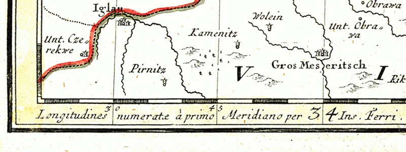
English: Detail of the map of Silesia drawn in 1746.
Larger towns:
Iglau = moravian town Jihlava
Gros Meseritsch = moravian town Velké Meziříčí
On the lowest edge of the map - Latin message:
Longitudines numeratæ à primo Meridiano per Insula Ferri - meaning the prime meridian for this map is El Hierro Island (known as Ferro as well)
Polski: Fragment mapy Górnego Śląska z roku 1746.
Większe miejscowości:
Iglau = morawskie miasto Jihlava
Gros Meseritsch = morawskie miasto Velké Meziříčí
Na samym dole przy krawędzi mapy łacińska informacja:
Longitudines numeratæ à primo Meridiano per Insula Ferri - oznaczająca, że południkiem odniesienia dla tej mapy jest południk wyspy El Hierro (znanej też jako Ferro)
Lisenziya
Bu şəkil, təsviri incəsənət əsərinin orijinal ikiölçülü dəqiq fotoqrafiya reproduksiyasıdır. Təsviri incəsənətin bu əsəri öz-özlüyündə aşağıdakı səbəblərdən ictimai varidat sayılır:
Public domainPublic domainfalsefalse
https://creativecommons.org/publicdomain/mark/1.0/PDMCreative Commons Public Domain Mark 1.0falsefalse
"Vikimedia Fondu" tutduğu rəsmi mövqe ondan ibarətdir ki, "ictimai varidat olan təsviri incəsənət əsərlərinin ikiölçülü dəqiq reproduksiyaları da ictimai varidat sayılır". Ətraflı məlumat almaq üçün Commons:When to use the PD-Art tag məqaləsinə baxın. Beləliklə bu fotoqrafiya reproduksiyası ictimai varidat hesab edilir. Xahiş edirik nəzərə alın ki, yerli qanunvericilikdən asılı olaraq bu məzmunun təkrar istifadəsi qadağandır və ya sizin yurisdiksiyanızda bu məzmun məhdudlaşdırılmış ola bilər. Commons:Reuse of PD-Art photographs məqaləsinə baxın.
{{PD-Art}} template without license parameter: please specify why the underlying work is public domain in both the source country and the United States (Usage: {{PD-Art|1=|deathyear=''year of author's death''|country=''source country''}}, where parameter #1 can be PD-old-auto, PD-old-auto-expired, PD-old-auto-1996, PD-old-100 or similar. See Commons:Multi-license copyright tags for more information.)
Captions
Add a one-line explanation of what this file represents
Part of map of Upper Silesia (1746) with Latin message: Longitudines numeratæ à primo Meridiano per Ins(ulam) Ferri
Detail van een kaart van Silezië uit 1746. Het onderschrift vermeldt: "Longitudines a Primo Meridiano per Insula Ferri."
Items portrayed in this file
təsvir edir
Velké Meziříčí ingilis
MIME type ingilis
image/jpeg
Faylın tarixçəsi
Faylın əvvəlki versiyasını görmək üçün gün/tarix bölməsindəki tarixlərə klikləyin.
{{en}} Detail of the map of Silesia drawn in 1746. *Iglau = moravian city en:JihlavaJihlava *Gros Meseritsch = moravian town Velké Meziříčí On the lowest edge of the
Bu faylda fotoaparat və ya skanerlə əlavə olunmuş məlumatlar var. Əgər fayl sonradan redaktə olunubsa, bəzi parametrlər bu şəkildə göstərilənlərdən fərqli ola bilər.
_error
0
September 10, 2023
fayl, 1746, longitudines, numeratae, primo, meridiano, insula, ferri, fayl, faylın, tarixçəsi, fayl, keçidləri, faylın, qlobal, istifadəsi, metaməlumatlardaha, yüksək, versiyası, yoxdur, 1746, longitudines, numeratae, primo, meridiano, insula, ferri, 8206, pik. Fayl Faylin tarixcesi Fayl kecidleri Faylin qlobal istifadesi MetamelumatlarDaha yuksek versiyasi yoxdur Map of 1746 Longitudines numeratae a Primo Meridiano per Insula Ferri jpg 8206 800 300 piksel fayl hecmi 104 KB MIME novu image jpeg Bu fayl Vikimedia Commons dadirve diger layihelerde istifade edile biler tesvir sehifesi Faylin tesvir sehifesine get Xulase English Detail of the map of Silesia drawn in 1746 Larger towns Iglau moravian town Jihlava Gros Meseritsch moravian town Velke Mezirici On the lowest edge of the map Latin message Longitudines numeratae a primo Meridiano per Insula Ferri meaning the prime meridian for this map is El Hierro Island known as Ferro as well Polski Fragment mapy Gornego Slaska z roku 1746 Wieksze miejscowosci Iglau morawskie miasto Jihlava Gros Meseritsch morawskie miasto Velke Mezirici Na samym dole przy krawedzi mapy lacinska informacja Longitudines numeratae a primo Meridiano per Insula Ferri oznaczajaca ze poludnikiem odniesienia dla tej mapy jest poludnik wyspy El Hierro znanej tez jako Ferro Lisenziya Bu sekil tesviri incesenet eserinin orijinal ikiolculu deqiq fotoqrafiya reproduksiyasidir Tesviri incesenetin bu eseri oz ozluyunde asagidaki sebeblerden ictimai varidat sayilir Public domain Public domain false false This work is in the public domain in its country of origin and other countries and areas where the copyright term is the author s life plus 70 years or fewer You must also include a United States public domain tag to indicate why this work is in the public domain in the United States nbsp Note that a few countries have copyright terms longer than 70 years Mexico has 100 years Jamaica has 95 years Colombia has 80 years and Guatemala and Samoa have 75 years This image may not be in the public domain in these countries which moreover do not implement the rule of the shorter term Honduras has a general copyright term of 75 years but it does implement the rule of the shorter term Copyright may extend on works created by French who died for France in World War II more information Russians who served in the Eastern Front of World War II known as the Great Patriotic War in Russia and posthumously rehabilitated victims of Soviet repressions more information This file has been identified as being free of known restrictions under copyright law including all related and neighboring rights https creativecommons org publicdomain mark 1 0 PDM Creative Commons Public Domain Mark 1 0 false false Vikimedia Fondu tutdugu resmi movqe ondan ibaretdir ki ictimai varidat olan tesviri incesenet eserlerinin ikiolculu deqiq reproduksiyalari da ictimai varidat sayilir Etrafli melumat almaq ucun Commons When to use the PD Art tag meqalesine baxin Belelikle bu fotoqrafiya reproduksiyasi ictimai varidat hesab edilir Xahis edirik nezere alin ki yerli qanunvericilikden asili olaraq bu mezmunun tekrar istifadesi qadagandir ve ya sizin yurisdiksiyanizda bu mezmun mehdudlasdirilmis ola biler Commons Reuse of PD Art photographs meqalesine baxin PD Art template without license parameter please specify why the underlying work is public domain in both the source country and the United States Usage PD Art 1 deathyear year of author s death country source country where parameter 1 can be PD old auto PD old auto expired PD old auto 1996 PD old 100 or similar See Commons Multi license copyright tags for more information CaptionsazerbaycancaAdd a one line explanation of what this file representsingilisPart of map of Upper Silesia 1746 with Latin message Longitudines numeratae a primo Meridiano per Ins ulam FerrihollandDetail van een kaart van Silezie uit 1746 Het onderschrift vermeldt Longitudines a Primo Meridiano per Insula Ferri Items portrayed in this filetesvir edirVelke Mezirici nbsp ingilisMIME type nbsp ingilisimage jpeg Faylin tarixcesi Faylin evvelki versiyasini gormek ucun gun tarix bolmesindeki tarixlere klikleyin Tarix VaxtKicik sekilOlculerIstifadeciSerh indiki20 21 4 dekabr 2005800 300 104 KB Julo en Detail of the map of Silesia drawn in 1746 Iglau moravian city en JihlavaJihlava Gros Meseritsch moravian town Velke Mezirici On the lowest edge of the Fayl kecidleri Bu sekile olan kecidler Ferro Meridiani Faylin qlobal istifadesi Bu fayl asagidaki vikilerde istifade olunur en wikipedia org layihesinde istifadesi El Hierro Ferro meridian eo wikipedia org layihesinde istifadesi Velke Mezirici fr wikipedia org layihesinde istifadesi Premier meridien Meridien de Ferro hu wikipedia org layihesinde istifadesi Jihlava it wikipedia org layihesinde istifadesi Meridiano di Ferro ja wikipedia org layihesinde istifadesi エル イエロ島 フェロ子午線 la wikipedia org layihesinde istifadesi Iglavia nl wikipedia org layihesinde istifadesi Nulmeridiaan Meridiaan van Ferro pl wikipedia org layihesinde istifadesi Dlugosc geograficzna El Hierro Wikipedysta Julo Galeria 6 Velke Mezirici sr wikipedia org layihesinde istifadesi Ferski meridiјanMetamelumatlar Bu faylda fotoaparat ve ya skanerle elave olunmus melumatlar var Eger fayl sonradan redakte olunubsa bezi parametrler bu sekilde gosterilenlerden ferqli ola biler error0 Menbe https az wikipedia org wiki Fayl Map of 1746 Longitudines numeratae a Primo Meridiano per Insula Ferri jpg, wikipedia, oxu, kitab, kitabxana, axtar, tap, hersey,
ne axtarsan burda
, en yaxsi meqale sayti, meqaleler, kitablar, oyrenmek, wiki, bilgi, tarix, seks, porno, indir, yukle, sex, azeri sex, azeri, seks yukle, sex yukle, izle, seks izle, porno izle, mobil seks, telefon ucun, chat, azeri chat, tanisliq, tanishliq, azeri tanishliq, sayt, medeni, medeni saytlar, chatlar, mekan, tanisliq mekani, mekanlari, yüklə, pulsuz, pulsuz yüklə, mp3, video, mp4, 3gp, jpg, jpeg, gif, png, şəkil, muisiqi, mahnı, kino, film, kitab, oyun, oyunlar.