Bu fayl "Vikimedia Commons"dadır və digər layihələrdə istifadə edilə bilər.
Faylın təsvir səhifəsinə get
Xülasə
İzahMap Crusader states 1135-en.svg
[redaktə]
Əgər edə bilsəniz, bu təsviri digər dillərə tərcümə edərək hamı üçün əlçatan etməsinə kömək edin. – Təşəkkür edirəm!
Čeština: Politická mapa Blízkého východu v roce 1135.
Deutsch: Die Levante, 1135, zwischen den Ersten und Zweiten Kreuzzügen. Kreuzzugsstaaten sind mit einem roten Kreuz gekennzeichnet
Eesti: Lähis-Ida (1135)
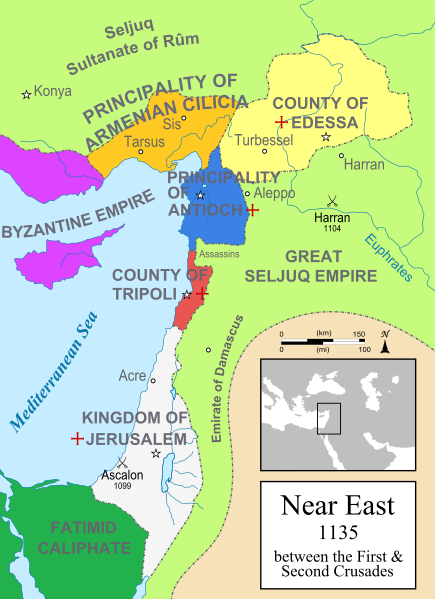
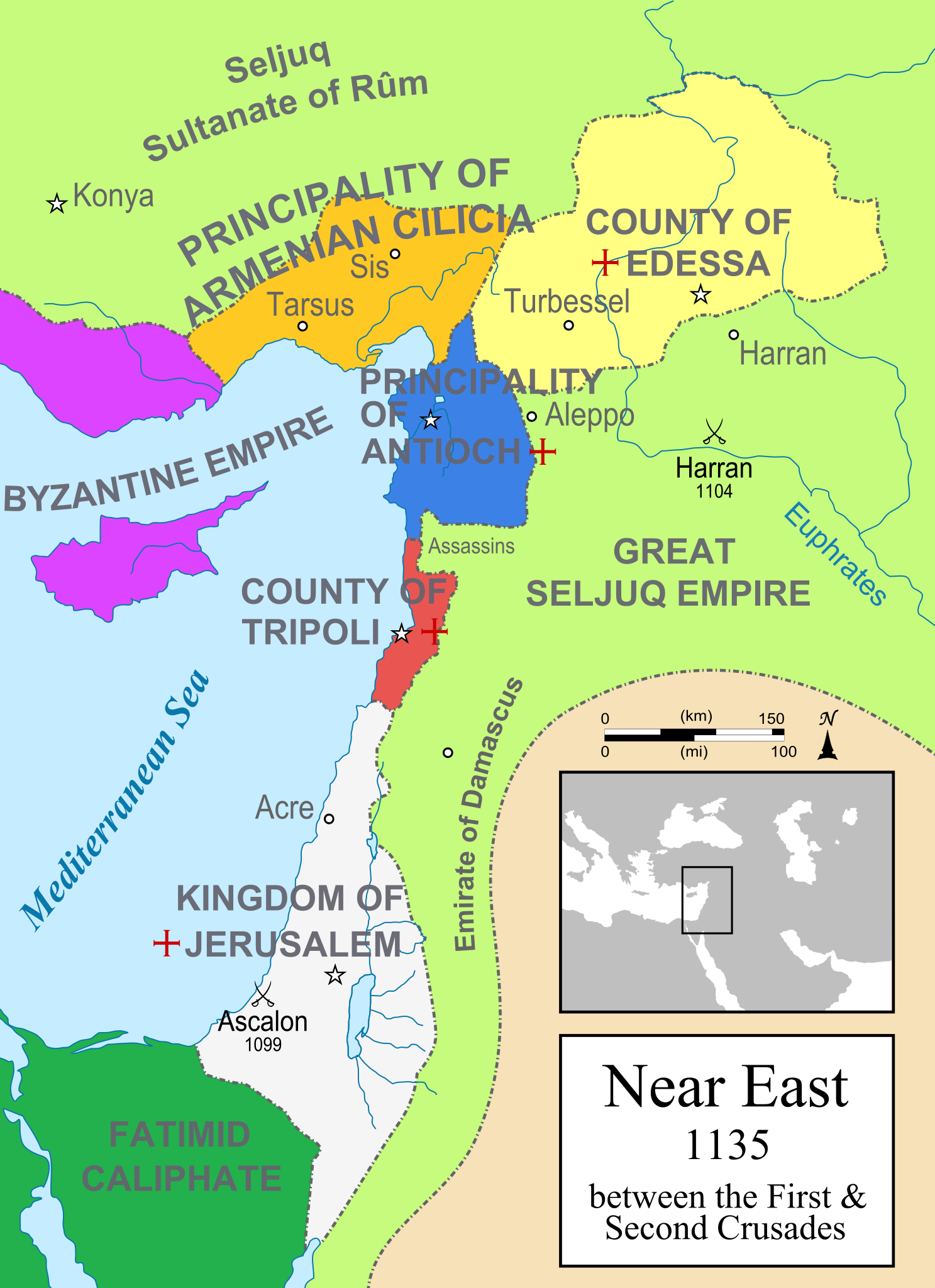
English: A political map of the Near East in 1135 CE. Crusader states are marked with a red cross.
Español : Oriente Próximo en 1135, entre la primera y segunda cruzadas.
Esperanto: Politika mapo de Levantenio dum 1135, inter la krucmilitaroj unuaj kaj duaj.
Français : Carte politique du Proche-Orient en 1135, entre la Première et la Seconde Croisades. les États latins d'Orient sont marqués d'une croix rouge.
Italiano : Carta politica del Vicino Oriente nel 1135.
Magyar: A Közel-Kelet térképe 1135-ben.
Polski: Mapa polityczna Bliskiego Wschodu w roku 1135, w okresie II krucjaty.
Ελληνικά: Πολιτικός χάρτης της Μέσης Ανατολής το 1135, ανάμεσα στην πρώτη και τη δεύτερη Σταυροφορία
Македонски: Политичка карта на Блискиот Исток во 1135 г. Крстоносните држави се означени со црвени крстови.
Русский: Карта Ближнего Востока в 1135 г.
Српски / srpski: Politička karta Bliskog Istoka 1135. godine, između Prvog i Drugog krstaškog pohoda. Krstaške države su označene crvenim krstom.
العربية : الدويلات الصليبية والدول الإسلامية المجاورة لها في الفترة بين الحملتين الصليبيتين الأولى والثانية.
فارسی : نسخه فارسی
Mənbə
Öz işi
Müəllif
MapMaster
Digər versiyalar
[redaktə]
čeština (çex)
Deutsch (alman)
English (ingilis) (original)
Esperanto (esperanto)
español (ispan) (1)
español (ispan) (2)
eesti (eston) (PNG)
français (fransız)
italiano (italyan) (PNG)
magyar (macar)
日本語 (yapon) (PNG)
Nederlands (holland)
polski (polyak)
português (portuqal)
македонски (makedon)
русский (rus)
Ελληνικά (yunan)
հայերեն (erməni)
ქართული (gürcü) (PNG)
中文 (çin)
العربية (ərəb) (PNG)
فارسی (fars) (PNG)
See also
Maps in 1102
Maps in 1165
Maps in 1190
Maps in 1197
Maps in 1240
SVG genesis
InfoField
The SVG code is valid.
This map was created with Inkscape.
References
Bjorklund, Oddvar; Holmboe, Haakon; Rohr, Anders (1970) Historical Atlas of the World, Barnes & Noble, NY, SBN: 389-00253-4.
Asia Minor and the Crusader states, c. 1140 from Findlay, Alexander G. (1849) Classical Atlas of Ancient Geography.
Map of the Crusader states from Muir's Historical Atlas (1911)
Lisenziya
I, the copyright holder of this work, hereby publish it under the following license:
Bu sənədi GNU Azad Sənədləşdirmə Lisenziyası, Versiya 1.2 və ya Azad Proqram Fondu tərəfindən nəşr olunan hər hansı sonrakı versiya şərtlərinə əsasən dəyişməz bölmələr, ön qapaq mətnləri və arxa qapaq mətnləri olmadan köçürmək, yayımlamaq və / və ya dəyişdirmək üçün icazə verilir; Lisenziyanın bir nüsxəsi GNU Azad Sənədləşdirmə Lisenziyası adlı hissəyə daxil edilmişdir.http://www.gnu.org/copyleft/fdl.htmlGFDLGNU Free Documentation Licensetruetrue
Bu fayl Creative Commons Attribution-Share Alike 3.0 Sinqapur lisenziyası altında yayımlanır.
Azadsınız:
paylaşmaq – əsəri köçürmək, paylamaq və ötürmək üçün
remiks etmək – əsəri adaptasiya etmək
Aşağıdakı şərtlərə riayət etməklə:
istinad – Müvafiq kredit verməlisiniz, lisenziyaya bir keçid verməlisiniz və dəyişikliklərin olub olmadığını bildirməlisiniz. Bunu hər hansı bir ağlabatan şəkildə edə bilərsiniz, ancaq lisenziyalaşdırıcının sizi və ya istifadənizi təsdiqləməsini təklif edən bir şəkildə deyil.
bənzər paylaşma – Əsəri remix edirsinizsə, dəyişdirirsinizsə və ya üzərində iş aparırsınızsa, öz töhfələrinizi orijinalda olduğu kimi eyni və ya uyğun lisenziya altında yayımlamalısınız.
This licensing tag was added to this file as part of the GFDL licensing update.http://creativecommons.org/licenses/by-sa/3.0/CC BY-SA 3.0Creative Commons Attribution-Share Alike 3.0truetrue
derivative works
Derivative works of this file:
Map Crusader states 1135-ar.png
Map Crusader states 1135-es.svg
Map Crusader states 1135-zh.svg
Map Crusader states 1135-es2.svg
Captions
Add a one-line explanation of what this file represents
Политическая карта Ближнего Востока в 1135 году. Государства крестоносцев обозначены красным крестом
Ekialdeko Mediterraneoa 1135ean; Gurutzatuen estatuak eta inguruko herrialdeak ageri dira
Bu faylda fotoaparat və ya skanerlə əlavə olunmuş məlumatlar var. Əgər fayl sonradan redaktə olunubsa, bəzi parametrlər bu şəkildə göstərilənlərdən fərqli ola bilər.
Genişlik
954.92731
Hündürlük
1315.1251
May 16, 2023
fayl, crusader, states, 1135, fayl, faylın, tarixçəsi, fayl, keçidləri, faylın, qlobal, istifadəsi, metaməlumatlarbu, faylın, formatındakı, görünüşünün, ölçüsü, piksel, digər, ölçülər, piksel, piksel, piksel, piksel, piksel, piksel, faylın, orijinalı, 8206, fa. Fayl Faylin tarixcesi Fayl kecidleri Faylin qlobal istifadesi MetamelumatlarBu SVG faylin PNG formatindaki bu gorunusunun olcusu 435 599 piksel Diger olculer 174 240 piksel 348 480 piksel 558 768 piksel 744 1 024 piksel 1 487 2 048 piksel 955 1 315 piksel Faylin orijinali 8206 SVG fayli nominal olaraq 955 1 315 piksel faylin olcusu 418 KB Bu fayl Vikimedia Commons dadirve diger layihelerde istifade edile biler Faylin tesvir sehifesine get Mundericat 1 Xulase 1 1 See also 2 References 3 Lisenziya 4 derivative works Xulase IzahMap Crusader states 1135 en svg redakte Eger ede bilseniz bu tesviri diger dillere tercume ederek hami ucun elcatan etmesine komek edin Tesekkur edirem Cestina Politicka mapa Blizkeho vychodu v roce 1135 Deutsch Die Levante 1135 zwischen den Ersten und Zweiten Kreuzzugen Kreuzzugsstaaten sind mit einem roten Kreuz gekennzeichnetEesti Lahis Ida 1135 English A political map of the Near East in 1135 CE Crusader states are marked with a red cross Espanol Oriente Proximo en 1135 entre la primera y segunda cruzadas Esperanto Politika mapo de Levantenio dum 1135 inter la krucmilitaroj unuaj kaj duaj Francais Carte politique du Proche Orient en 1135 entre la Premiere et la Seconde Croisades les Etats latins d Orient sont marques d une croix rouge Italiano Carta politica del Vicino Oriente nel 1135 Magyar A Kozel Kelet terkepe 1135 ben Polski Mapa polityczna Bliskiego Wschodu w roku 1135 w okresie II krucjaty Ellhnika Politikos xarths ths Meshs Anatolhs to 1135 anamesa sthn prwth kai th deyterh StayroforiaMakedonski Politichka karta na Bliskiot Istok vo 1135 g Krstonosnite drzhavi se oznacheni so crveni krstovi Russkij Karta Blizhnego Vostoka v 1135 g Srpski srpski Politicka karta Bliskog Istoka 1135 godine između Prvog i Drugog krstaskog pohoda Krstaske drzave su oznacene crvenim krstom ქართული ახლო აღმოსავლეთი 1135 წელსithy aephnthitawnxxkklang khs 1135 rahwangkhruesdkhrngthi 1 aelakhrngthi 2日本語 1135年の近東情勢 赤い十字を名称に冠しているは第一回十字軍によって建てられた十字軍国家 中文 一副关于1135年近东地区局势的地图 标注红色十字的为十字军国家العربية nbsp الدويلات الصليبية والدول الإسلامية المجاورة لها في الفترة بين الحملتين الصليبيتين الأولى والثانية فارسی nbsp نسخه فارسی Menbe Oz isi Muellif MapMaster Diger versiyalar redakte cestina cex Deutsch alman English ingilis original Esperanto esperanto espanol ispan 1 espanol ispan 2 eesti eston PNG francais fransiz italiano italyan PNG magyar macar 日本語 yapon PNG Nederlands holland polski polyak portugues portuqal makedonski makedon russkij rus Ellhnika yunan հայերեն ermeni ქართული gurcu PNG 中文 cin العربية ereb PNG فارسی fars PNG See also Maps in 1102 Maps in 1165 Maps in 1190 Maps in 1197 Maps in 1240 SVG nbsp genesisInfoField nbsp The SVG code is valid nbsp This map was created with Inkscape References Bjorklund Oddvar Holmboe Haakon Rohr Anders 1970 Historical Atlas of the World Barnes amp Noble NY SBN 389 00253 4 Asia Minor and the Crusader states c 1140 from Findlay Alexander G 1849 Classical Atlas of Ancient Geography Map of the Crusader states from Muir s Historical Atlas 1911 Lisenziya I the copyright holder of this work hereby publish it under the following license Bu senedi GNU Azad Senedlesdirme Lisenziyasi Versiya 1 2 ve ya Azad Proqram Fondu terefinden nesr olunan her hansi sonraki versiya sertlerine esasen deyismez bolmeler on qapaq metnleri ve arxa qapaq metnleri olmadan kocurmek yayimlamaq ve ve ya deyisdirmek ucun icaze verilir Lisenziyanin bir nusxesi GNU Azad Senedlesdirme Lisenziyasi adli hisseye daxil edilmisdir http www gnu org copyleft fdl html GFDL GNU Free Documentation License true true Bu fayl Creative Commons Attribution Share Alike 3 0 Sinqapur lisenziyasi altinda yayimlanir Azadsiniz paylasmaq eseri kocurmek paylamaq ve oturmek ucun remiks etmek eseri adaptasiya etmek Asagidaki sertlere riayet etmekle istinad Muvafiq kredit vermelisiniz lisenziyaya bir kecid vermelisiniz ve deyisikliklerin olub olmadigini bildirmelisiniz Bunu her hansi bir aglabatan sekilde ede bilersiniz ancaq lisenziyalasdiricinin sizi ve ya istifadenizi tesdiqlemesini teklif eden bir sekilde deyil benzer paylasma Eseri remix edirsinizse deyisdirirsinizse ve ya uzerinde is aparirsinizsa oz tohfelerinizi orijinalda oldugu kimi eyni ve ya uygun lisenziya altinda yayimlamalisiniz This licensing tag was added to this file as part of the GFDL licensing update http creativecommons org licenses by sa 3 0 CC BY SA 3 0 Creative Commons Attribution Share Alike 3 0 true true derivative works Derivative works of this file Map Crusader states 1135 ar png Map Crusader states 1135 es svg Map Crusader states 1135 zh svg Map Crusader states 1135 es2 svgCaptionsazerbaycancaAdd a one line explanation of what this file representsrusPoliticheskaya karta Blizhnego Vostoka v 1135 godu Gosudarstva krestonoscev oboznacheny krasnym krestombaskEkialdeko Mediterraneoa 1135ean Gurutzatuen estatuak eta inguruko herrialdeak ageri diraItems portrayed in this filetesvir ediryaradiciSome value without a Vikiverilenler itemmuellifin qisa adi MapMasterWikimedia username nbsp ingilis MapMasterURL nbsp ingilis https commons wikimedia org wiki user MapMastercopyright status nbsp ingiliscopyrighted nbsp ingilislisenziyaGNU Free Documentation License version 1 2 or later nbsp ingilisCreative Commons Attribution ShareAlike 3 0 Unported nbsp ingilissource of file nbsp ingilisoriginal creation by uploader nbsp ingilisMIME type nbsp ingilisimage svg xml Faylin tarixcesi Faylin evvelki versiyasini gormek ucun gun tarix bolmesindeki tarixlere klikleyin en yeni en evvelki Goster 10 daha yeni 10 daha kohne 10 20 50 100 250 500 Tarix VaxtKicik sekilOlculerIstifadeciSerh indiki21 01 19 mart 2015955 1 315 418 KB DennissReverted to version as of 09 13 25 July 2012 13 03 19 mart 2015955 1 315 433 KB DorudgarTranslation from English to Arabic الترجمة من الإنگليزية إلى العربية 09 13 25 iyul 2012955 1 315 418 KB HorsefaCeCilicia wan 039 t a kingdom yet 09 08 25 iyul 2012955 1 315 120 KB HorsefaCeA Chinese version 11 48 12 iyul 2010955 1 315 418 KB Malus CatulusCilicia wan 039 t a kingdom yet 10 59 12 iyul 2010955 1 315 424 KB Malus CatulusCorrected burid dynasty 22 01 11 iyul 2010955 1 315 418 KB Malus CatulusFinal tweaks 21 52 11 iyul 2010955 1 315 403 KB Malus CatulusNow complies with w3c so I hope the box is gone 21 22 11 iyul 2010955 1 315 403 KB Malus CatulusTrying to remove black box 21 18 11 iyul 2010955 1 315 402 KB Malus CatulusForgot to convert Med sea and Euphrates to path en yeni en evvelki Goster 10 daha yeni 10 daha kohne 10 20 50 100 250 500 Fayl kecidleri Bu sekile olan kecidler Yeruselim kralligi Ikinci Selib yurusu Faylin qlobal istifadesi Bu fayl asagidaki vikilerde istifade olunur an wikipedia org layihesinde istifadesi Reino de Cherusalem Prencipau d Antioquia ast wikipedia org layihesinde istifadesi Edesa Condau de Tripoli azb wikipedia org layihesinde istifadesi بؤری امیرلیگی بیرینجی صلیب یوروشو صلیب یوروشلری طرابلوس کونتلوغو انطاکیه دوکلیغی اورشلیم شاهلیغی بیرینجی مانوئل ایکینجی صلیب یوروشو ba wikipedia org layihesinde istifadesi Bojok Sәlzhүk imperiyaһy Fәlәstin tarihy Tәre jorotoүselәr dәүlәttәre be wikipedia org layihesinde istifadesi Ierusalimskae karaleystva Fulk Ierusalimski Dzyarzhavy kryzhakoy Kilikijskae carstva bg wikipedia org layihesinde istifadesi Jerusalimsko kralstvo Boemund I Antiohijski Antiohijsko knyazhestvo Grafstvo Edesa Grafstvo Tripoli Vizantijska rekonkista Krstonosna drzhava Grafstvo Yafa i Askalon Senoriya Ramla Senoriya Ibelin Senoriya Mirabel Saladinov zamk Istoriya na hristiyanstvoto bn wikipedia org layihesinde istifadesi ব র র জব শ স ল হ দ দ ন র র জপ র স দ জ র স ল ম র জ য br wikipedia org layihesinde istifadesi Stadou latin ar Reter bxr wikipedia org layihesinde istifadesi Dunda zuun Hereeһetenej ayan dajn ca wikipedia org layihesinde istifadesi Comtat de Tripoli Primera Croada Edessa Mesopotamia Regne de Jerusalem Comtat d Edessa Principat d Antioquia Setge d Edessa Setge de Damasc 1148 Noms del Llevant ckb wikipedia org layihesinde istifadesi شانشینی قودس cs wikipedia org layihesinde istifadesi Burijovci Krizova vyprava roku 1129 Bu faylin qlobal istifadesine baxin Metamelumatlar Bu faylda fotoaparat ve ya skanerle elave olunmus melumatlar var Eger fayl sonradan redakte olunubsa bezi parametrler bu sekilde gosterilenlerden ferqli ola biler Genislik954 92731Hundurluk1315 1251 Menbe https az wikipedia org wiki Fayl Map Crusader states 1135 en svg, wikipedia, oxu, kitab, kitabxana, axtar, tap, hersey,
ne axtarsan burda
, en yaxsi meqale sayti, meqaleler, kitablar, oyrenmek, wiki, bilgi, tarix, seks, porno, indir, yukle, sex, azeri sex, azeri, seks yukle, sex yukle, izle, seks izle, porno izle, mobil seks, telefon ucun, chat, azeri chat, tanisliq, tanishliq, azeri tanishliq, sayt, medeni, medeni saytlar, chatlar, mekan, tanisliq mekani, mekanlari, yüklə, pulsuz, pulsuz yüklə, mp3, video, mp4, 3gp, jpg, jpeg, gif, png, şəkil, muisiqi, mahnı, kino, film, kitab, oyun, oyunlar.