Bu fayl "Vikimedia Commons"dadır və digər layihələrdə istifadə edilə bilər.
təsvir səhifəsi
Faylın təsvir səhifəsinə get
İzahManchukuo map 1939.svg
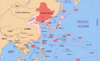
English: A map of the Manchukuo, 1939-09-01. Dates shown indicate the approximate year that Japan gain control of the possession. Japanese control of territory in China was tenuous.
I, the copyright holder of this work, hereby publish it under the following licenses:
Bu fayl Creative Commons Attribution-Share Alike 3.0 Sinqapur lisenziyası altında yayımlanır.
Azadsınız:
paylaşmaq – əsəri köçürmək, paylamaq və ötürmək üçün
remiks etmək – əsəri adaptasiya etmək
Aşağıdakı şərtlərə riayət etməklə:
istinad – Müvafiq kredit verməlisiniz, lisenziyaya bir keçid verməlisiniz və dəyişikliklərin olub olmadığını bildirməlisiniz. Bunu hər hansı bir ağlabatan şəkildə edə bilərsiniz, ancaq lisenziyalaşdırıcının sizi və ya istifadənizi təsdiqləməsini təklif edən bir şəkildə deyil.
bənzər paylaşma – Əsəri remix edirsinizsə, dəyişdirirsinizsə və ya üzərində iş aparırsınızsa, öz töhfələrinizi orijinalda olduğu kimi eyni və ya uyğun lisenziya altında yayımlamalısınız.
Bu sənədi GNU Azad Sənədləşdirmə Lisenziyası, Versiya 1.2 və ya Azad Proqram Fondu tərəfindən nəşr olunan hər hansı sonrakı versiya şərtlərinə əsasən dəyişməz bölmələr, ön qapaq mətnləri və arxa qapaq mətnləri olmadan köçürmək, yayımlamaq və / və ya dəyişdirmək üçün icazə verilir; Lisenziyanın bir nüsxəsi GNU Azad Sənədləşdirmə Lisenziyası adlı hissəyə daxil edilmişdir.http://www.gnu.org/copyleft/fdl.htmlGFDLGNU Free Documentation Licensetruetrue
İstədiyiniz lisenziyanı seçə bilərsiniz.
Orijinal yükləmə gündəliyi
This image is a derivative work of the following images:
Image:Pacific_Area_-_The_Imperial_Powers_1939_-_Map.svg licensed with Cc-by-sa-3.0, GFDL
Bu faylda fotoaparat və ya skanerlə əlavə olunmuş məlumatlar var. Əgər fayl sonradan redaktə olunubsa, bəzi parametrlər bu şəkildə göstərilənlərdən fərqli ola bilər.
Genişlik
633.70892
Hündürlük
386.62335
Yanvar 09, 2024
fayl, manchukuo, 1939, fayl, faylın, tarixçəsi, fayl, keçidləri, faylın, qlobal, istifadəsi, metaməlumatlarbu, faylın, formatındakı, görünüşünün, ölçüsü, piksel, digər, ölçülər, piksel, piksel, piksel, piksel, piksel, faylın, orijinalı, 8206, faylı, nominal, o. Fayl Faylin tarixcesi Fayl kecidleri Faylin qlobal istifadesi MetamelumatlarBu SVG faylin PNG formatindaki bu gorunusunun olcusu 634 387 piksel Diger olculer 320 195 piksel 640 391 piksel 1 024 625 piksel 1 280 781 piksel 2 560 1 563 piksel Faylin orijinali 8206 SVG fayli nominal olaraq 634 387 piksel faylin olcusu 2 23 MB Bu fayl Vikimedia Commons dadirve diger layihelerde istifade edile biler tesvir sehifesi Faylin tesvir sehifesine get IzahManchukuo map 1939 svg English A map of the Manchukuo 1939 09 01 Dates shown indicate the approximate year that Japan gain control of the possession Japanese control of territory in China was tenuous Tarix avqust 2008 Menbe Pacific Area The Imperial Powers 1939 Map svg Muellif derivative work Emok talk Pacific Area The Imperial Powers 1939 Map svg derivative work Emok talk World2Hires filled mercator svg Emok Image Pacific Area The Imperial Powers 1939 Map jpg Diger versiyalar Manchukuo catala Pacific Area Korea Manchukuo Mengjiang Taiwan I the copyright holder of this work hereby publish it under the following licenses Bu fayl Creative Commons Attribution Share Alike 3 0 Sinqapur lisenziyasi altinda yayimlanir Azadsiniz paylasmaq eseri kocurmek paylamaq ve oturmek ucun remiks etmek eseri adaptasiya etmek Asagidaki sertlere riayet etmekle istinad Muvafiq kredit vermelisiniz lisenziyaya bir kecid vermelisiniz ve deyisikliklerin olub olmadigini bildirmelisiniz Bunu her hansi bir aglabatan sekilde ede bilersiniz ancaq lisenziyalasdiricinin sizi ve ya istifadenizi tesdiqlemesini teklif eden bir sekilde deyil benzer paylasma Eseri remix edirsinizse deyisdirirsinizse ve ya uzerinde is aparirsinizsa oz tohfelerinizi orijinalda oldugu kimi eyni ve ya uygun lisenziya altinda yayimlamalisiniz https creativecommons org licenses by sa 3 0 CC BY SA 3 0 Creative Commons Attribution Share Alike 3 0 true true Bu senedi GNU Azad Senedlesdirme Lisenziyasi Versiya 1 2 ve ya Azad Proqram Fondu terefinden nesr olunan her hansi sonraki versiya sertlerine esasen deyismez bolmeler on qapaq metnleri ve arxa qapaq metnleri olmadan kocurmek yayimlamaq ve ve ya deyisdirmek ucun icaze verilir Lisenziyanin bir nusxesi GNU Azad Senedlesdirme Lisenziyasi adli hisseye daxil edilmisdir http www gnu org copyleft fdl html GFDL GNU Free Documentation License true trueIstediyiniz lisenziyani sece bilersiniz Orijinal yukleme gundeliyi This image is a derivative work of the following images Image Pacific Area The Imperial Powers 1939 Map svg licensed with Cc by sa 3 0 GFDL 2008 08 08T01 16 33Z Emok 1039x814 4678233 Bytes Information Description Source Date Author Permission other versions 2008 08 08T00 07 48Z Emok 1039x814 4669659 Bytes Information Description Source Date Author Permission other versions 2008 08 07T05 03 23Z Emok 1039x814 4669195 Bytes Information Description Source Date Author Permission other versions 2008 08 07T04 28 58Z Emok 1039x814 4623405 Bytes Information Description Source Date Author Permission other versions 2008 08 07T04 02 57Z Emok 1039x814 4602891 Bytes Information Description Source Date Author Permission other versions 2008 08 07T03 24 03Z Emok 1039x814 4669511 Bytes Information Description Source Date Author Permission other versions 2008 08 04T16 59 39Z Emok 1039x814 6442489 Bytes Information Description Source Date Author Permission other versions 2008 08 04T05 38 24Z Emok 1039x814 6427678 Bytes Information Description Source Date Author Permission other versions Category Imperialism Category Oceania 2008 08 04T05 26 00Z Emok 104x82 4765313 Bytes Information Description en 1 A map of the Imperial Powers of the Pacific 1939 09 01 Source Image World2Hires filled mercator svg Date 2008 08 04 05 22 UTC Author derivative work Image World2Hir Uploaded with derivativeFXCaptionsazerbaycancaAdd a one line explanation of what this file representsingilisLocation of Manchukuo red in Imperial Japan s region of influence 1939 Items portrayed in this filetesvir edircopyright status nbsp ingiliscopyrighted nbsp ingilislisenziyaGNU Free Documentation License version 1 2 or later nbsp ingilisCreative Commons Attribution ShareAlike 3 0 Unported nbsp ingilisyaranma tarixi1 avqust 2008 Faylin tarixcesi Faylin evvelki versiyasini gormek ucun gun tarix bolmesindeki tarixlere klikleyin en yeni en evvelki Goster 10 daha yeni 10 daha kohne 10 20 50 100 250 500 Tarix VaxtKicik sekilOlculerIstifadeciSerh indiki14 48 16 sentyabr 2023634 387 2 23 MB KajenCATFile uploaded using svgtranslate tool https svgtranslate toolforge org Added translation for ca 15 17 2 iyun 2023634 387 2 2 MB SmallJarsWithGreenLabelsre applying sp changes because this site sucks and gave me the old version of the svg for my second edit 23 33 1 iyun 2023634 387 2 2 MB SmallJarsWithGreenLabelssaipan per user Geographyinitiative 23 18 1 iyun 2023634 387 2 19 MB SmallJarsWithGreenLabelssp 01 37 27 avqust 2010634 387 2 21 MB SplittistNo reason for Xinjiang to have separate borders from China 23 29 30 may 2009634 387 2 21 MB SelfQ commonswikiCluttering and removal of key elements is not acceptable If you want a Chineese version please upload on under its own file name 10 44 17 may 20091 300 1 201 864 KB Xiamipi增加中文说明 02 52 21 avqust 2008634 387 2 21 MB Emok Information Description Source Date Author Permission other versions 02 41 21 avqust 2008634 387 2 21 MB Emok Information Description Source Date Author Permission other versions 01 41 8 avqust 2008634 387 2 2 MB Emok Information Description Source Date Author Permission other versions en yeni en evvelki Goster 10 daha yeni 10 daha kohne 10 20 50 100 250 500 Fayl kecidleri Bu sekile olan kecidler Mancjou qo Faylin qlobal istifadesi Bu fayl asagidaki vikilerde istifade olunur ar wikipedia org layihesinde istifadesi مانشوكو azb wikipedia org layihesinde istifadesi مانچوکوئو bg wikipedia org layihesinde istifadesi Mandzhou Go bs wikipedia org layihesinde istifadesi Sile Osovine ca wikipedia org layihesinde istifadesi Potencies de l Eix da wikipedia org layihesinde istifadesi Manchukuo el wikipedia org layihesinde istifadesi Mantsoykoyo en wikipedia org layihesinde istifadesi Manchukuo Puppet state Client state Nobusuke Kishi History of Manchuria List of national border changes 1914 present Japanese invasion of Manchuria Wikipedia Graphics Lab Image workshop Archive Aug 2008 Talk Empire of Japan Archive 1 User RedStorm1368 sandbox fa wikipedia org layihesinde istifadesi حمله ژاپن به منچوری مانچوکوئو fr wikipedia org layihesinde istifadesi Histoire de la Mandchourie hr wikipedia org layihesinde istifadesi Mandzukuo hy wikipedia org layihesinde istifadesi Մասնակից Paylun Baghdasaryan Ավազարկղ1 Հաճախորդ պետություն id wikipedia org layihesinde istifadesi Blok Poros Negara boneka it wikipedia org layihesinde istifadesi Manciukuo Corsa agli armamenti Invasione giapponese della Manciuria ja wikipedia org layihesinde istifadesi 従属国 ja wikibooks org layihesinde istifadesi 中学校社会 歴史 満州事変 中学受験社会 歴史 下巻 小学校社会 6学年 歴史編 下巻 jv wikipedia org layihesinde istifadesi Poros Perang Donya II lt wikipedia org layihesinde istifadesi Asis politika lv wikipedia org layihesinde istifadesi Mandzukuo mk wikipedia org layihesinde istifadesi Manџukuo Јaponska invaziјa na Manџuriјa mn wikipedia org layihesinde istifadesi Manzh go ms wikipedia org layihesinde istifadesi Manchukuo no wikipedia org layihesinde istifadesi Mandsjukuo pt wikipedia org layihesinde istifadesi Manchukuo Estado fantoche sh wikipedia org layihesinde istifadesi Sile Osovine simple wikipedia org layihesinde istifadesi Island sl wikipedia org layihesinde istifadesi Mandzuko sr wikipedia org layihesinde istifadesi Marionetska drzhava Sile Osovine ta wikipedia org layihesinde istifadesi மஞ ச க uk wikipedia org layihesinde istifadesi Kliyentska derzhava uz wikipedia org layihesinde istifadesi Yaponiyaning Manchjuriyaga bosqiniMetamelumatlar Bu faylda fotoaparat ve ya skanerle elave olunmus melumatlar var Eger fayl sonradan redakte olunubsa bezi parametrler bu sekilde gosterilenlerden ferqli ola biler Genislik633 70892Hundurluk386 62335 Menbe https az wikipedia org wiki Fayl Manchukuo map 1939 svg, wikipedia, oxu, kitab, kitabxana, axtar, tap, hersey,
ne axtarsan burda
, en yaxsi meqale sayti, meqaleler, kitablar, oyrenmek, wiki, bilgi, tarix, seks, porno, indir, yukle, sex, azeri sex, azeri, seks yukle, sex yukle, izle, seks izle, porno izle, mobil seks, telefon ucun, chat, azeri chat, tanisliq, tanishliq, azeri tanishliq, sayt, medeni, medeni saytlar, chatlar, mekan, tanisliq mekani, mekanlari, yüklə, pulsuz, pulsuz yüklə, mp3, video, mp4, 3gp, jpg, jpeg, gif, png, şəkil, muisiqi, mahnı, kino, film, kitab, oyun, oyunlar.