Alemannisch ∙ العربية ∙ беларуская (тарашкевіца) ∙ български ∙ বাংলা ∙ català ∙ нохчийн ∙ čeština ∙ dansk ∙ Deutsch ∙ Ελληνικά ∙ English ∙ British English ∙ Esperanto ∙ español ∙ eesti ∙ euskara ∙ فارسی ∙ suomi ∙ français ∙ Frysk ∙ galego ∙ עברית ∙ hrvatski ∙ magyar ∙ հայերեն ∙ Bahasa Indonesia ∙ Ido ∙ italiano ∙ 日本語 ∙ ქართული ∙ 한국어 ∙ lietuvių ∙ македонски ∙ മലയാളം ∙ Bahasa Melayu ∙ norsk bokmål ∙ Plattdüütsch ∙ Nederlands ∙ norsk nynorsk ∙ norsk ∙ occitan ∙ polski ∙ português ∙ português do Brasil ∙ română ∙ русский ∙ sicilianu ∙ Scots ∙ slovenčina ∙ slovenščina ∙ српски / srpski ∙ svenska ∙ தமிழ் ∙ ไทย ∙ Türkçe ∙ татарча/tatarça ∙ українська ∙ vèneto ∙ Tiếng Việt ∙ 中文(简体) ∙ 中文(繁體) ∙ +/−
Captions
Add a one-line explanation of what this file represents
Items portrayed in this file
təsvir edir
copyright status ingilis
copyrighted, dedicated to the public domain by copyright holder ingilis
lisenziya
released into the public domain by the copyright holder ingilis
yaranma tarixi
17 sentyabr 2006
Faylın tarixçəsi
Faylın əvvəlki versiyasını görmək üçün gün/tarix bölməsindəki tarixlərə klikləyin.
(ən yeni | ən əvvəlki) Göstər (10 daha yeni) (10 daha köhnə) (10 | 20 | 50 | 100 | 250 | 500).
Showing borders that are recognized. Still showing unrecognized countries for a reference of where Ancient Greek was. It was also about the shape of the lands, as Greek Islands where either not shown correctly or not there at all
Pfrevious user Saguamundi is right. International borders, and NOT disputed borders must be shown. Nor is this about the present but about historical Greek settlements. There is no place for current politics for a historical map.
update more to source, the current Greece was not under territory.
(ən yeni | ən əvvəlki) Göstər (10 daha yeni) (10 daha köhnə) (10 | 20 | 50 | 100 | 250 | 500).
İstifadə edilən səhifələr
Bu faylı istifadə edən səhifə yoxdur.
Faylın qlobal istifadəsi
Bu fayl aşağıdakı vikilərdə istifadə olunur:
pl.wikibooks.org layihəsində istifadəsi
Wikipedysta:Ananas96/Starożytna Grecja - Wstęp
Metaməlumatlar
Bu faylda fotoaparat və ya skanerlə əlavə olunmuş məlumatlar var. Əgər fayl sonradan redaktə olunubsa, bəzi parametrlər bu şəkildə göstərilənlərdən fərqli ola bilər.
Üfüqi xətt
56,69 dpc
Şaquli xətt
56,69 dpc
Dekabr 26, 2022
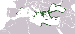
fayl, location, greek, ancient, fayl, faylın, tarixçəsi, istifadə, edilən, səhifələr, faylın, qlobal, istifadəsi, metaməlumatlardaha, yüksək, versiyası, yoxdur, location, greek, ancient, 8206, piksel, fayl, həcmi, mime, növü, image, fayl, vikimedia, commons, d. Fayl Faylin tarixcesi Istifade edilen sehifeler Faylin qlobal istifadesi MetamelumatlarDaha yuksek versiyasi yoxdur Location greek ancient png 8206 248 113 piksel fayl hecmi 4 KB MIME novu image png Bu fayl Vikimedia Commons dadirve diger layihelerde istifade edile biler Faylin tesvir sehifesine get Xulase IzahLocation greek ancient png English Locator map depicting the ancient Greek world c 550 BCTarix 17 sentyabr 2006Menbe Self created after http www wwnorton com nrl english nawol maps MAP7GRCO JPGMuellif User ChrisOIcaze Faylin tekrar istifadesi Public domain Public domain false falseMen bu eserin muellif huquqlarinin sahibi kimi eseri ictimai mulkiyyete verirem Bu icaze butun dunyada quvvededir In some countries this may not be legally possible if so Bunun qanunla mumkun olmadigi hallarda Istenilen sexse istenilen meqsed ucun qanunlar terefinden qadagan edilmeyince hec bir sert qoymadan bu isden istifade haqqini bagislayiram Diger versiyalar File Location greek ancient svg is a vector version of this file It should be used in place of this PNG file when not inferior File Location greek ancient png File Location greek ancient svg For more information see Help SVG In other languagesAlemannisch العربية belaruskaya tarashkevica blgarski ব ল catala nohchijn cestina dansk Deutsch Ellhnika English British English Esperanto espanol eesti euskara فارسی suomi francais Frysk galego עברית hrvatski magyar հայերեն Bahasa Indonesia Ido italiano 日本語 ქართული 한국어 lietuviu makedonski മലയ ള Bahasa Melayu norsk bokmal Plattduutsch Nederlands norsk nynorsk norsk occitan polski portugues portugues do Brasil romană russkij sicilianu Scots slovencina slovenscina srpski srpski svenska தம ழ ithy Turkce tatarcha tatarca ukrayinska veneto Tiếng Việt 中文 简体 中文 繁體 CaptionsazerbaycancaAdd a one line explanation of what this file representsItems portrayed in this filetesvir edircopyright status ingiliscopyrighted dedicated to the public domain by copyright holder ingilislisenziyareleased into the public domain by the copyright holder ingilisyaranma tarixi17 sentyabr 2006 Faylin tarixcesi Faylin evvelki versiyasini gormek ucun gun tarix bolmesindeki tarixlere klikleyin en yeni en evvelki Goster 10 daha yeni 10 daha kohne 10 20 50 100 250 500 Tarix VaxtKicik sekilOlculerIstifadeciSerh indiki16 20 27 sentyabr 2021248 113 4 KB Deji Olajide1999Added the missing regions of Orestis Elimiotis Eordaia and Tymphaea cleared up the Greek colonies in Thrace 09 22 23 yanvar 2018248 113 4 KB MaphobbyistAdded Colchis 16 15 26 iyun 2014248 113 6 KB SilentResidentAdded missing kingdom of Epirus 10 55 29 dekabr 2012248 113 5 KB GepgepgepAggiunta l 039 area di colonizzazione greca dell 039 Adriatico che mancava completamente 17 22 5 sentyabr 2011248 113 5 KB Spesh531Showing borders that are recognized Still showing unrecognized countries for a reference of where Ancient Greek was It was also about the shape of the lands as Greek Islands where either not shown correctly or not there at all 13 00 5 sentyabr 2011248 113 4 KB MaphobbyistPfrevious user Saguamundi is right International borders and NOT disputed borders must be shown Nor is this about the present but about historical Greek settlements There is no place for current politics for a historical map 22 28 4 sentyabr 2011248 113 5 KB Spesh531Reverted to version as of 01 56 11 May 2011 The border were fine your showing territories where some are unrecognizable 22 21 4 sentyabr 2011248 113 5 KB Spesh531Reverted to version as of 01 56 11 May 2011 The border were fine your showing territories where some are unrecognizable 21 26 4 sentyabr 2011248 113 4 KB SaguamundiSame map but with internationally recognized borders 01 56 11 may 2011248 113 5 KB Spesh531update more to source the current Greece was not under territory en yeni en evvelki Goster 10 daha yeni 10 daha kohne 10 20 50 100 250 500 Istifade edilen sehifeler Bu fayli istifade eden sehife yoxdur Faylin qlobal istifadesi Bu fayl asagidaki vikilerde istifade olunur en wikipedia org layihesinde istifadesi Talk Juniperus bermudiana pl wikibooks org layihesinde istifadesi Wikipedysta Ananas96 Starozytna Grecja WstepMetamelumatlar Bu faylda fotoaparat ve ya skanerle elave olunmus melumatlar var Eger fayl sonradan redakte olunubsa bezi parametrler bu sekilde gosterilenlerden ferqli ola biler Ufuqi xett56 69 dpcSaquli xett56 69 dpc Menbe https az wikipedia org wiki Fayl Location greek ancient png, wikipedia, oxu, kitab, kitabxana, axtar, tap, hersey,
ne axtarsan burda
, en yaxsi meqale sayti, meqaleler, kitablar, oyrenmek, wiki, bilgi, tarix, seks, porno, indir, yukle, sex, azeri sex, azeri, seks yukle, sex yukle, izle, seks izle, porno izle, mobil seks, telefon ucun, chat, azeri chat, tanisliq, tanishliq, azeri tanishliq, sayt, medeni, medeni saytlar, chatlar, mekan, tanisliq mekani, mekanlari, yüklə, pulsuz, pulsuz yüklə, mp3, video, mp4, 3gp, jpg, jpeg, gif, png, şəkil, muisiqi, mahnı, kino, film, kitab, oyun, oyunlar.