Bu fayl "Vikimedia Commons"dadır və digər layihələrdə istifadə edilə bilər.
Faylın təsvir səhifəsinə get
Xülasə
İzahLivingston-Island-Map-2010-15.png
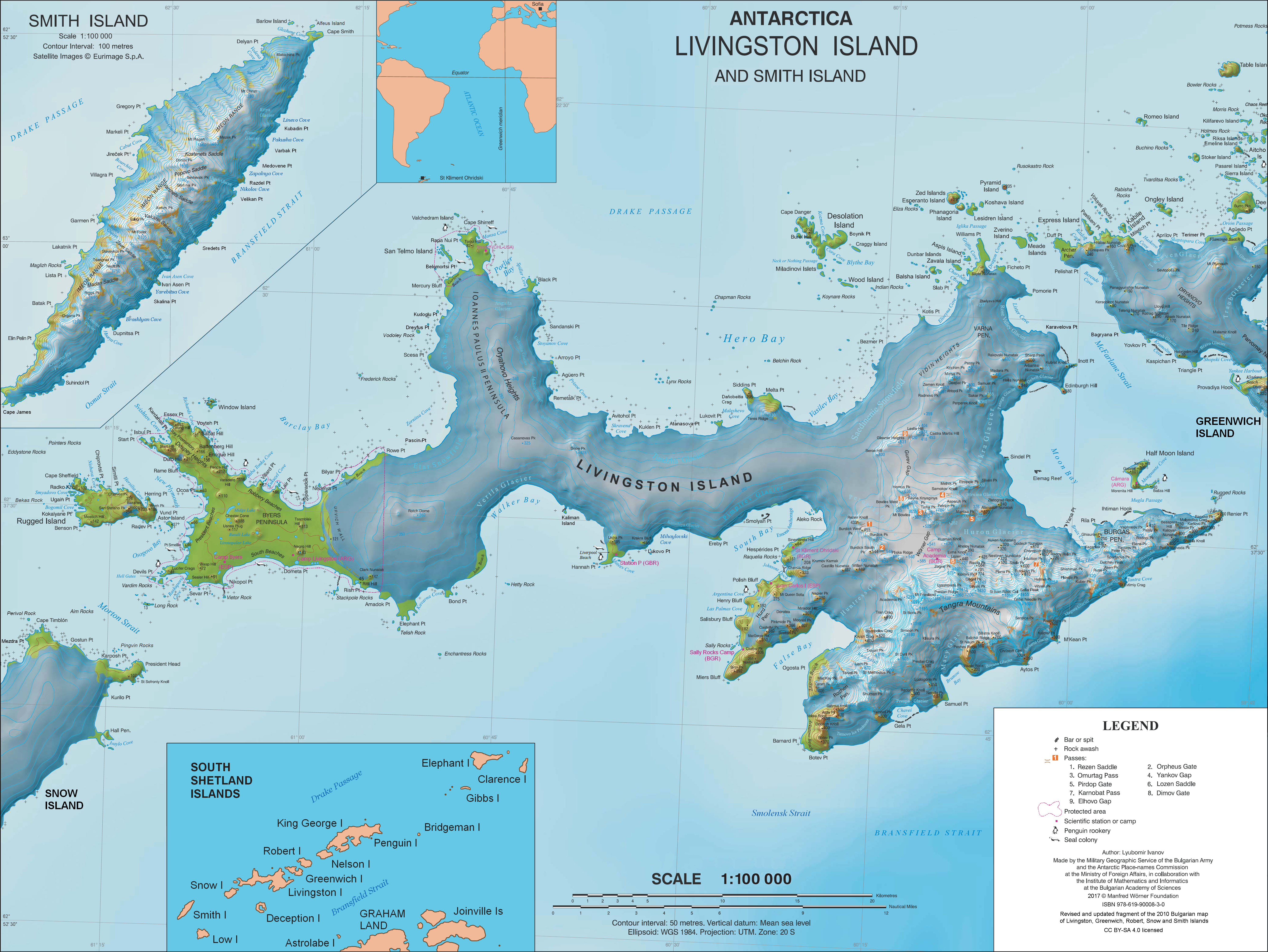
English: L.L. Ivanov. Antarctica: Livingston Island and Smith Island. Scale 1:100000 topographic map. Manfred Wörner Foundation, 2017. ISBN 978-619-90008-3-0
Tarix
Mənbə
Öz işi
Müəllif
Apcbg
İcazə (Faylın təkrar istifadəsi)
Published by the Manfred Wörner Foundation under the Creative Commons Attribution ShareAlike 4.0 license.
Digər versiyalar
File:Livingston-Island-Map-2010.jpg, an earlier version
Lisenziya
I, the copyright holder of this work, hereby publish it under the following license:
This file is licensed under the Creative Commons Attribution-Share Alike 4.0 International license.
Azadsınız:
paylaşmaq – əsəri köçürmək, paylamaq və ötürmək üçün
remiks etmək – əsəri adaptasiya etmək
Aşağıdakı şərtlərə riayət etməklə:
istinad – Müvafiq kredit verməlisiniz, lisenziyaya bir keçid verməlisiniz və dəyişikliklərin olub olmadığını bildirməlisiniz. Bunu hər hansı bir ağlabatan şəkildə edə bilərsiniz, ancaq lisenziyalaşdırıcının sizi və ya istifadənizi təsdiqləməsini təklif edən bir şəkildə deyil.
bənzər paylaşma – Əsəri remix edirsinizsə, dəyişdirirsinizsə və ya üzərində iş aparırsınızsa, öz töhfələrinizi orijinalda olduğu kimi eyni və ya uyğun lisenziya altında yayımlamalısınız.
Bu faylda fotoaparat və ya skanerlə əlavə olunmuş məlumatlar var. Əgər fayl sonradan redaktə olunubsa, bəzi parametrlər bu şəkildə göstərilənlərdən fərqli ola bilər.
Üfüqi xətt
37,8 dpc
Şaquli xətt
37,8 dpc
Proqram təminatı
IrfanView
İyun 05, 2023
fayl, livingston, island, 2010, fayl, faylın, tarixçəsi, fayl, keçidləri, faylın, qlobal, istifadəsi, metaməlumatlarsınaq, göstərişi, ölçüsü, piksel, digər, ölçülər, piksel, piksel, piksel, piksel, piksel, piksel, faylın, orijinalı, 8206, piksel, fayl, həcmi, . Fayl Faylin tarixcesi Fayl kecidleri Faylin qlobal istifadesi MetamelumatlarSinaq gosterisi olcusu 799 600 piksel Diger olculer 320 240 piksel 640 480 piksel 1 023 768 piksel 1 280 961 piksel 2 560 1 922 piksel 5 337 4 006 piksel Faylin orijinali 8206 5 337 4 006 piksel fayl hecmi 9 65 MB MIME novu image png Bu fayl Vikimedia Commons dadirve diger layihelerde istifade edile biler Faylin tesvir sehifesine get Xulase IzahLivingston Island Map 2010 15 png English L L Ivanov Antarctica Livingston Island and Smith Island Scale 1 100000 topographic map Manfred Worner Foundation 2017 ISBN nbsp 978 619 90008 3 0 Tarix 31 mart 2017 Menbe Oz isi Muellif Apcbg Icaze Faylin tekrar istifadesi Published by the Manfred Worner Foundation under the Creative Commons Attribution ShareAlike 4 0 license Diger versiyalar File Livingston Island Map 2010 jpg an earlier version Lisenziya I the copyright holder of this work hereby publish it under the following license This file is licensed under the Creative Commons Attribution Share Alike 4 0 International license Azadsiniz paylasmaq eseri kocurmek paylamaq ve oturmek ucun remiks etmek eseri adaptasiya etmek Asagidaki sertlere riayet etmekle istinad Muvafiq kredit vermelisiniz lisenziyaya bir kecid vermelisiniz ve deyisikliklerin olub olmadigini bildirmelisiniz Bunu her hansi bir aglabatan sekilde ede bilersiniz ancaq lisenziyalasdiricinin sizi ve ya istifadenizi tesdiqlemesini teklif eden bir sekilde deyil benzer paylasma Eseri remix edirsinizse deyisdirirsinizse ve ya uzerinde is aparirsinizsa oz tohfelerinizi orijinalda oldugu kimi eyni ve ya uygun lisenziya altinda yayimlamalisiniz https creativecommons org licenses by sa 4 0 CC BY SA 4 0 Creative Commons Attribution Share Alike 4 0 true trueCaptionsazerbaycancaAdd a one line explanation of what this file representsingilisTopographic map of Livingston Island and Smith Island AntarcticaItems portrayed in this filetesvir ediryaradiciSome value without a Vikiverilenler itemWikimedia username nbsp ingilis ApcbgURL https commons wikimedia org wiki user Apcbgmuellifin qisa adi Apcbgcopyright status nbsp ingiliscopyrighted nbsp ingilislisenziyaCreative Commons Attribution ShareAlike 4 0 International nbsp ingilisyaranma tarixi31 mart 2017source of file nbsp ingilisoriginal creation by uploader nbsp ingilisMIME type nbsp ingilisimage png Faylin tarixcesi Faylin evvelki versiyasini gormek ucun gun tarix bolmesindeki tarixlere klikleyin en yeni en evvelki Goster 10 daha yeni 10 daha kohne 10 20 50 100 250 500 Tarix VaxtKicik sekilOlculerIstifadeciSerh indiki10 28 2 aprel 20215 337 4 006 9 65 MB Apcbgupdate 13 21 27 iyun 20195 337 4 006 9 65 MB Apcbgminor update 12 21 23 may 20195 337 4 006 9 65 MB Apcbgupdate 08 22 19 mart 20195 337 4 006 9 65 MB Apcbgminor update 21 14 9 fevral 20195 337 4 006 9 66 MB ApcbgUpdate 15 35 5 fevral 20195 337 4 006 9 66 MB ApcbgMinor 19 20 2 fevral 20195 337 4 006 9 66 MB ApcbgUpdate 06 44 9 avqust 20185 337 4 006 9 66 MB ApcbgUpdate 06 17 8 avqust 20185 337 4 006 9 66 MB ApcbgUpdate 11 38 31 mart 20175 337 4 006 10 92 MB ApcbgUpdated topography and toponymy en yeni en evvelki Goster 10 daha yeni 10 daha kohne 10 20 50 100 250 500 Fayl kecidleri Bu sekile olan kecidler Livinqston adasi Faylin qlobal istifadesi Bu fayl asagidaki vikilerde istifade olunur ar wikipedia org layihesinde istifadesi الربوة الإسبانية ast wikipedia org layihesinde istifadesi Base Antartica Juan Carlos I bg wikipedia org layihesinde istifadesi Sveti Kliment Ohridski baza Livingstn ostrov Tangra planina Montana vrh Akademiya vrh Ajtos nos Avitohol nos Carigrad vrh Lyaskovec vrh Frisland vrh Vidinski vzvisheniya Kucoto kuche Sveti Boris vrh Simeon vrh Varna poluostrov Sveti Ivan Rilski rid ca wikipedia org layihesinde istifadesi Illa Livingston Base Antartica Joan Carles I Campament Byers ceb wikipedia org layihesinde istifadesi Pliska Ridge Mesa pulo de wikipedia org layihesinde istifadesi Livingston Insel Table Island Sudliche Shetlandinseln Barclay Bay Kap Shirreff Johannes Paul II Halbinsel Hero Bay Desolation Island Sudliche Shetlandinseln Burdick Peak Black Point Livingston Insel Blythe Bay Hemus Peak Leslie Hill Livingston Insel Brunow Bay Bravo Gletscher McFarlane Strait Renier Point Burdick South Peak Burdick West Peak Willan Nunatak Pliska Ridge Rotch Dome Cora Cove Craggy Island Sudliche Shetlandinseln Eddystone Rocks Sudliche Shetlandinseln Inott Point Punta Aguayo Punta La Caverna Bu faylin qlobal istifadesine baxin Metamelumatlar Bu faylda fotoaparat ve ya skanerle elave olunmus melumatlar var Eger fayl sonradan redakte olunubsa bezi parametrler bu sekilde gosterilenlerden ferqli ola biler Ufuqi xett37 8 dpcSaquli xett37 8 dpcProqram teminatiIrfanView Menbe https az wikipedia org wiki Fayl Livingston Island Map 2010 15 png, wikipedia, oxu, kitab, kitabxana, axtar, tap, hersey,
ne axtarsan burda
, en yaxsi meqale sayti, meqaleler, kitablar, oyrenmek, wiki, bilgi, tarix, seks, porno, indir, yukle, sex, azeri sex, azeri, seks yukle, sex yukle, izle, seks izle, porno izle, mobil seks, telefon ucun, chat, azeri chat, tanisliq, tanishliq, azeri tanishliq, sayt, medeni, medeni saytlar, chatlar, mekan, tanisliq mekani, mekanlari, yüklə, pulsuz, pulsuz yüklə, mp3, video, mp4, 3gp, jpg, jpeg, gif, png, şəkil, muisiqi, mahnı, kino, film, kitab, oyun, oyunlar.