Bu fayl "Vikimedia Commons"dadır və digər layihələrdə istifadə edilə bilər.
Faylın təsvir səhifəsinə get
Xülasə
İzahKharimkotan - ISS005.jpg
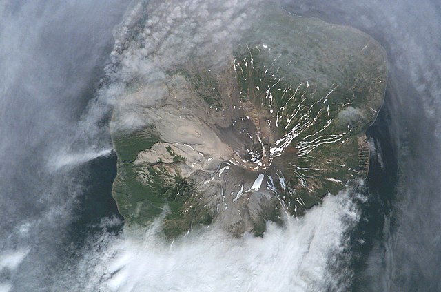
English: Kharimkotan, of the Kuril Islands. Photographed from the International Space Station.
Čeština: Charim(u)kotan ( japonsky: 春牟古丹島, Harumukotan-tó/Harimukotan-tó; rusky: Остров Харимкотан) je ostrov v severní části Kurilského souostroví, vzdálený 13 kilometrů od jihovýchodního cípu Onekotanu, od nějž je oddělen Krenicynovým průlivem. Rozloha Charimkotanu je 68 km² a tvoří ho stejnojmenná sopka vysoká 1157 m. n. m. Její vrchol tvoří dva krátery, které vznikly propadem horních částí svahu. Vypouklé poloostrovy na východním a severozápadním pobřeží vděčí za svůj vznik právě zmíněnému propadu. Na snímku je možno spatřit další, podobně formovaný vulkanický konus - Severgin. Jeho propadem a následným sesutím části ostrova do moře, vnzikla roku 1993 tsunami.
한국어: 하림코탄 섬( 러시아어: Харимкотан, 일본어: 春牟古丹島, 아이누어: ハリム)는 쿠릴 열도 중부에 위치한 섬이다. 면적은 13km이고, 삼각형 모양의 섬이다.
Русский: Харимкотан — остров в Северной группе Большой гряды Курильских островов. Административно входит в Северо-Курильский район Сахалинской области.
ISS Crew Earth Observations: ISS005-E-6517
Identification
Mission
ISS005 (Expedition 5)
Roll
E
Frame
6517
Country or Geographic Name
RUSSIAN FEDERATION
Features
KHARIMKOTAN I., KURIL I.
Center Point Latitude
49.0° N
Center Point Longitude
154.5° E
Camera
Camera Tilt
13°
Camera Focal Length
800 mm
Camera
Kodak DCS760C Electronic Still Camera
Film
3060 x 2036 pixel CCD, RGBG array.
Quality
Percentage of Cloud Cover
26-50%
Nadir What is Nadir?
Date
2002-06-30
Time
22:18:21
Nadir Point Latitude
49.0° N
Nadir Point Longitude
155.3° E
Nadir to Photo Center Direction
West
Sun Azimuth
104°
Spacecraft Altitude
210 nautical miles (390 km)
Sun Elevation Angle
43°
Orbit Number
621
Tarix
Mənbə
ISS005-E-6517
Müəllif
unidentified astronaut
İcazə (Faylın təkrar istifadəsi)
PD-NASA
Camera location
49° 07′ 12″ N, 154° 30′ 28,8″ E
View this and other nearby images on: OpenStreetMap
49.120000; 154.508000
Lisenziya
Public domainPublic domainfalsefalse
Captions
Add a one-line explanation of what this file represents
Items portrayed in this file
təsvir edir
yaranma tarixi
30 iyun 2002
coordinates of the point of view ingilis
49°7'12.000"N, 154°30'28.800"E
Faylın tarixçəsi
Faylın əvvəlki versiyasını görmək üçün gün/tarix bölməsindəki tarixlərə klikləyin.
{{Information |Description={{w|Kharimkotan}}, of the {{w|Kuril Islands}}. Photographed from the International Space Station. |Source=NASA/JSC Gateway to Astronaut Photography of Earth. http://eol.jsc.nasa.gov/scripts/sseop/photo.pl?mission=ISS005&roll=E&
fayl, kharimkotan, iss005, fayl, faylın, tarixçəsi, fayl, keçidləri, faylın, qlobal, istifadəsisınaq, göstərişi, ölçüsü, piksel, digər, ölçülər, piksel, piksel, piksel, piksel, piksel, faylın, orijinalı, 8206, piksel, fayl, həcmi, mime, növü, image, jpeg, fayl. Fayl Faylin tarixcesi Fayl kecidleri Faylin qlobal istifadesiSinaq gosterisi olcusu 800 530 piksel Diger olculer 320 212 piksel 640 424 piksel 1 024 678 piksel 1 280 848 piksel 3 032 2 008 piksel Faylin orijinali 8206 3 032 2 008 piksel fayl hecmi 1 17 MB MIME novu image jpeg Bu fayl Vikimedia Commons dadirve diger layihelerde istifade edile biler Faylin tesvir sehifesine get Xulase IzahKharimkotan ISS005 jpg English Kharimkotan of the Kuril Islands Photographed from the International Space Station Cestina Charim u kotan japonsky 春牟古丹島 Harumukotan to Harimukotan to rusky Ostrov Harimkotan je ostrov v severni casti Kurilskeho souostrovi vzdaleny 13 kilometru od jihovychodniho cipu Onekotanu od nejz je oddelen Krenicynovym prulivem Rozloha Charimkotanu je 68 km a tvori ho stejnojmenna sopka vysoka 1157 m n m Jeji vrchol tvori dva kratery ktere vznikly propadem hornich casti svahu Vypoukle poloostrovy na vychodnim a severozapadnim pobrezi vdeci za svuj vznik prave zminenemu propadu Na snimku je mozno spatrit dalsi podobne formovany vulkanicky konus Severgin Jeho propadem a naslednym sesutim casti ostrova do more vnzikla roku 1993 tsunami 日本語 春牟古丹島 はりむこたんとう はるむこたんとう は中部千島 捨子古丹島の北東方 捨子古丹海峡 ロシア名セヴェルギナ海峡 pr Severgina を挟んだおよそ16浬にある 長さ約13キロメートル 幅8キロメートルの北西方を頂点とした三角形の島である ロシア連邦が実効支配しているが 日本政府は 国際法上は所属未定であると主張している ロシア名ハリムコタン島 o Harimkotan 第二次世界大戦終了後 サンフランシスコ講和条約によって日本は領有権を放棄している 한국어 하림코탄 섬 러시아어 Harimkotan 일본어 春牟古丹島 아이누어 ハリム 는 쿠릴 열도 중부에 위치한 섬이다 면적은 13km이고 삼각형 모양의 섬이다 Russkij Harimkotan ostrov v Severnoj gruppe Bolshoj gryady Kurilskih ostrovov Administrativno vhodit v Severo Kurilskij rajon Sahalinskoj oblasti ISS Crew Earth Observations ISS005 E 6517 Identification Mission ISS005 Expedition 5 Roll E Frame 6517 Country or Geographic Name RUSSIAN FEDERATION Features KHARIMKOTAN I KURIL I Center Point Latitude 49 0 N Center Point Longitude 154 5 E Camera Camera Tilt 13 Camera Focal Length 800 nbsp mm Camera Kodak DCS760C Electronic Still Camera Film 3060 x 2036 pixel CCD RGBG array Quality Percentage of Cloud Cover 26 50 Nadir What is Nadir Date 2002 06 30 Time 22 18 21 Nadir Point Latitude 49 0 N Nadir Point Longitude 155 3 E Nadir to Photo Center Direction West Sun Azimuth 104 Spacecraft Altitude 210 nautical miles 390 nbsp km Sun Elevation Angle 43 Orbit Number 621 Tarix 30 iyun 2002 Menbe ISS005 E 6517 Muellif unidentified astronaut Icaze Faylin tekrar istifadesi PD NASA Camera location49 nbsp 07 nbsp 12 nbsp N 154 nbsp 30 nbsp 28 8 nbsp E nbsp View this and other nearby images on OpenStreetMap49 120000 154 508000 Lisenziya Public domain Public domain false false This file is in the public domain in the United States because it was created by the Image Science amp Analysis Laboratory of the NASA Johnson Space Center NASA copyright policy states that NASA material is not protected by copyright unless noted NASA media use guidelines or Conditions of Use of Astronaut Photographs Photo source ISS005 E 6517 العربي ة nbsp Deutsch nbsp English nbsp espanol nbsp francais nbsp italiano nbsp kurdi nbsp makedonski nbsp മലയ ള nbsp portugues nbsp sicilianu nbsp CaptionsazerbaycancaAdd a one line explanation of what this file representsItems portrayed in this filetesvir ediryaranma tarixi30 iyun 2002coordinates of the point of view nbsp ingilis49 7 12 000 N 154 30 28 800 E Faylin tarixcesi Faylin evvelki versiyasini gormek ucun gun tarix bolmesindeki tarixlere klikleyin Tarix VaxtKicik sekilOlculerIstifadeciSerh indiki21 36 1 fevral 20073 032 2 008 1 17 MB Davepapecropped image ID from bottom 21 30 1 fevral 20073 032 2 064 1 51 MB Davepape Information Description w Kharimkotan of the w Kuril Islands Photographed from the International Space Station Source NASA JSC Gateway to Astronaut Photography of Earth http eol jsc nasa gov scripts sseop photo pl mission ISS005 amp roll E amp Fayl kecidleri Bu sekile olan kecidler Xarimkotan Faylin qlobal istifadesi Bu fayl asagidaki vikilerde istifade olunur ace wikipedia org layihesinde istifadesi Pulo Kharimkotan af wikipedia org layihesinde istifadesi Charimkotan arz wikipedia org layihesinde istifadesi خاريمكوتان be wikipedia org layihesinde istifadesi Harymkatan bg wikipedia org layihesinde istifadesi Kurilski vulkani Vulkan na Severgin ceb wikipedia org layihesinde istifadesi Vulkan Severgina Ostrov Kharimkotan cs wikipedia org layihesinde istifadesi Charimkotan de wikipedia org layihesinde istifadesi Charimkotan Liste von Vulkanen in Russland en wikipedia org layihesinde istifadesi Kharimkotan es wikipedia org layihesinde istifadesi Anexo Islas por punto mas alto Jarimkotan et wikipedia org layihesinde istifadesi Harimkotan eu wikipedia org layihesinde istifadesi Kharimkotan fr wikipedia org layihesinde istifadesi Kharimkotan it wikipedia org layihesinde istifadesi Charimkotan ja wikipedia org layihesinde istifadesi 春牟古丹島 ka wikipedia org layihesinde istifadesi სევერგინის ვულკანი ko wikipedia org layihesinde istifadesi 하림코탄섬 nl wikipedia org layihesinde istifadesi Charimkotan nn wikipedia org layihesinde istifadesi Kharimkotan no wikipedia org layihesinde istifadesi Kharimkotan pt wikipedia org layihesinde istifadesi Usuario DarwIn Vulcoes ru wikipedia org layihesinde istifadesi Harimkotan Spisok vulkanov Rossii Vulkan Severgina uk wikipedia org layihesinde istifadesi Spisok vulkaniv Rosiyi www wikidata org layihesinde istifadesi Q1063222 Q4128314 zh wikipedia org layihesinde istifadesi 春牟古丹島 Menbe https az wikipedia org wiki Fayl Kharimkotan ISS005 jpg, wikipedia, oxu, kitab, kitabxana, axtar, tap, hersey,
ne axtarsan burda
, en yaxsi meqale sayti, meqaleler, kitablar, oyrenmek, wiki, bilgi, tarix, seks, porno, indir, yukle, sex, azeri sex, azeri, seks yukle, sex yukle, izle, seks izle, porno izle, mobil seks, telefon ucun, chat, azeri chat, tanisliq, tanishliq, azeri tanishliq, sayt, medeni, medeni saytlar, chatlar, mekan, tanisliq mekani, mekanlari, yüklə, pulsuz, pulsuz yüklə, mp3, video, mp4, 3gp, jpg, jpeg, gif, png, şəkil, muisiqi, mahnı, kino, film, kitab, oyun, oyunlar.