Bu fayl "Vikimedia Commons"dadır və digər layihələrdə istifadə edilə bilər.
təsvir səhifəsi
Faylın təsvir səhifəsinə get
Xülasə
İzahKayseri districts.png
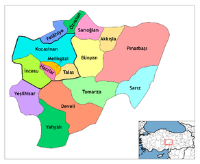
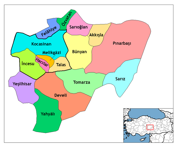
Map of the districts of Kayseri province in Turkey. Created by Rarelibra 21:59, 1 December 2006 (UTC) for public domain use, using MapInfo Professional v8.5 and various mapping resources. Edited by One Homo Sapiens Corrected text where İ, Ş, ı, ğ, or ş occurs in name. Source: [statoids-com]. Increased font size and enhanced color differences among adjacent districts. User:Sae1962 Marked the boundaries of the provincial centre, the city of Kayseri, with bold lines.
Tarix
1 dekabr 2006 (original upload date)
Mənbə
No machine-readable source provided. Own work assumed (based on copyright claims).
Müəllif
No machine-readable author provided. Rarelibra assumed (based on copyright claims).
Lisenziya
Public domainPublic domainfalsefalse
Captions
Add a one-line explanation of what this file represents
Items portrayed in this file
təsvir edir
copyright status ingilis
copyrighted, dedicated to the public domain by copyright holder ingilis
lisenziya
released into the public domain by the copyright holder ingilis
yaranma tarixi
1 dekabr 2006
Faylın tarixçəsi
Faylın əvvəlki versiyasını görmək üçün gün/tarix bölməsindəki tarixlərə klikləyin.
{{Information |Description=Map of the districts of Kayseri province in Turkey. Created by Rarelibra 21:59, 1 December 2006 (UTC) for public domain use, using MapInfo Professional v8.5 and various mapping resources. Edited by [[User:One
Map of the districts of Kayseri province in Turkey. Created by ~~~~ for public domain use, using MapInfo Professional v8.5 and various mapping resources.
fayl, kayseri, districts, fayl, faylın, tarixçəsi, fayl, keçidləri, faylın, qlobal, istifadəsisınaq, göstərişi, ölçüsü, piksel, digər, ölçülər, piksel, piksel, piksel, faylın, orijinalı, 8206, piksel, fayl, həcmi, mime, növü, image, fayl, vikimedia, commons, d. Fayl Faylin tarixcesi Fayl kecidleri Faylin qlobal istifadesiSinaq gosterisi olcusu 729 600 piksel Diger olculer 292 240 piksel 583 480 piksel 999 822 piksel Faylin orijinali 8206 999 822 piksel fayl hecmi 51 KB MIME novu image png Bu fayl Vikimedia Commons dadirve diger layihelerde istifade edile biler tesvir sehifesi Faylin tesvir sehifesine get Xulase IzahKayseri districts png Map of the districts of Kayseri province in Turkey Created by Rarelibra 21 59 1 December 2006 UTC for public domain use using MapInfo Professional v8 5 and various mapping resources Edited by One Homo Sapiens Corrected text where I S i g or s occurs in name Source statoids com Increased font size and enhanced color differences among adjacent districts User Sae1962 Marked the boundaries of the provincial centre the city of Kayseri with bold lines Tarix 1 dekabr 2006 original upload date Menbe No machine readable source provided Own work assumed based on copyright claims Muellif No machine readable author provided Rarelibra assumed based on copyright claims Lisenziya Public domain Public domain false false Men bu eserin muellif huquqlarinin sahibi kimi eseri ictimai mulkiyyete verirem Bu icaze butun dunyada quvvededir In some countries this may not be legally possible if so Bunun qanunla mumkun olmadigi hallarda Istenilen sexse istenilen meqsed ucun qanunlar terefinden qadagan edilmeyince hec bir sert qoymadan bu isden istifade haqqini bagislayiram CaptionsazerbaycancaAdd a one line explanation of what this file representsItems portrayed in this filetesvir edircopyright status nbsp ingiliscopyrighted dedicated to the public domain by copyright holder nbsp ingilislisenziyareleased into the public domain by the copyright holder nbsp ingilisyaranma tarixi1 dekabr 2006 Faylin tarixcesi Faylin evvelki versiyasini gormek ucun gun tarix bolmesindeki tarixlere klikleyin Tarix VaxtKicik sekilOlculerIstifadeciSerh indiki11 25 30 iyul 2009999 822 51 KB Sae1962 Information Description Map of the districts of Kayseri province in Turkey Created by Rarelibra 21 59 1 December 2006 UTC for public domain use using MapInfo Professional v8 5 and various mapping resources Edited by User One 08 24 4 may 2009999 822 50 KB Sae1962Added long vowels for better reading 23 54 28 dekabr 20081 056 816 35 KB One Homo SapiensCorrected text where I S i g or s occurs in name Source statoids com Increased font size and enhanced color differences among adjacent districts 21 59 1 dekabr 20061 056 816 33 KB RarelibraMap of the districts of Kayseri province in Turkey Created by for public domain use using MapInfo Professional v8 5 and various mapping resources Fayl kecidleri Bu sekile olan kecidler Kayseri ili Faylin qlobal istifadesi Bu fayl asagidaki vikilerde istifade olunur ast wikipedia org layihesinde istifadesi Distritos de Turquia be wikipedia org layihesinde istifadesi Kajsery pravincyya ca wikipedia org layihesinde istifadesi Kayseri Provincia de Kayseri Districtes de Turquia cs wikipedia org layihesinde istifadesi Kayseri provincie de wikipedia org layihesinde istifadesi Kayseri Talas Kayseri Yahyali Hacilar Kayseri Talas Bezirk Tomarza Wikipedia Kartenwerkstatt Archiv 2011 01 Wikipedia Kartenwerkstatt Archiv 2011 05 Develi Kayseri Vorlage Navigationsleiste Landkreise der Provinz Kayseri Akkisla Bunyan Felahiye Incesu Kayseri Kocasinan Melikgazi Ozvatan Pinarbasi Kayseri Sarioglan Sariz Yesilhisar Kayseri diq wikipedia org layihesinde istifadesi Qeze Tirkiya Qeyseriye en wikipedia org layihesinde istifadesi Kayseri Kayseri Province Felahiye Hacilar Incesu Kayseri Kocasinan Melikgazi Ozvatan Sarioglan Sariz Tomarza Yahyali Yesilhisar Talas Turkey Akkisla Bunyan Develi User talk Rarelibra Maps4 Pinarbasi Kayseri Districts of Turkey Governor of Kayseri Bu faylin qlobal istifadesine baxin Menbe https az wikipedia org wiki Fayl Kayseri districts png, wikipedia, oxu, kitab, kitabxana, axtar, tap, hersey,
ne axtarsan burda
, en yaxsi meqale sayti, meqaleler, kitablar, oyrenmek, wiki, bilgi, tarix, seks, porno, indir, yukle, sex, azeri sex, azeri, seks yukle, sex yukle, izle, seks izle, porno izle, mobil seks, telefon ucun, chat, azeri chat, tanisliq, tanishliq, azeri tanishliq, sayt, medeni, medeni saytlar, chatlar, mekan, tanisliq mekani, mekanlari, yüklə, pulsuz, pulsuz yüklə, mp3, video, mp4, 3gp, jpg, jpeg, gif, png, şəkil, muisiqi, mahnı, kino, film, kitab, oyun, oyunlar.