Bu fayl "Vikimedia Commons"dadır və digər layihələrdə istifadə edilə bilər.
Faylın təsvir səhifəsinə get
The factual accuracy of this map or the file name is disputed.
Reason: This map implies sovereignty over areas later known as Upper Palatinate, which in fact were frankish respective imperial territory at this point in time. Willi P (müzakirə) 19:29, 23 April 2023 (UTC)
İzahKarte Herzogtum Bayern im 10. Jahrhundert.png
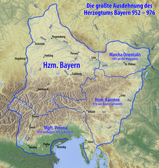
Deutsch: Karte des Herzogtums Bayern im 10. Jahrhundert
Tarix
see file history
Mənbə
Öz işi, using
information from this map by Electionworld
map data from maps-for-free.com
Müəllif
Maximilian Dörrbecker (Chumwa)
İcazə (Faylın təkrar istifadəsi)
I, the copyright holder of this work, hereby publish it under the following license:
Bu fayl Creative Commons Attribution-Share Alike 3.0 Sinqapur lisenziyası altında yayımlanır.
Azadsınız:
paylaşmaq – əsəri köçürmək, paylamaq və ötürmək üçün
remiks etmək – əsəri adaptasiya etmək
Aşağıdakı şərtlərə riayət etməklə:
istinad – Müvafiq kredit verməlisiniz, lisenziyaya bir keçid verməlisiniz və dəyişikliklərin olub olmadığını bildirməlisiniz. Bunu hər hansı bir ağlabatan şəkildə edə bilərsiniz, ancaq lisenziyalaşdırıcının sizi və ya istifadənizi təsdiqləməsini təklif edən bir şəkildə deyil.
bənzər paylaşma – Əsəri remix edirsinizsə, dəyişdirirsinizsə və ya üzərində iş aparırsınızsa, öz töhfələrinizi orijinalda olduğu kimi eyni və ya uyğun lisenziya altında yayımlamalısınız.
Sie dürfen das Bild zu den folgenden Bedingungen nutzen:
Sie müssen den Namen des Autors nennen.
Im Falle einer Verbreitung müssen Sie anderen die Lizenzbedingungen, unter die dieses Bild fällt, mitteilen.
Sie müssen das Bild unter gleichen Bedingungen weitergeben. Wenn sie das Bild abändern oder Arbeiten auf diesem Bild aufbauen, müssen Sie das Ergebnis aus dieser Arbeit ebenfalls unter diese Lizenz stellen.
Jede dieser Bedingungen kann nach schriftlicher Einwilligung des Rechtsinhabers aufgehoben werden.
Digər versiyalar
This image could be re-created using vector graphics as an SVG file. This has several advantages; see Commons:Media for cleanup for more information. If an SVG form of this image is available, please upload it and afterwards replace this template with {{vector version available|new image name}}. It is recommended to name the SVG file "Karte Herzogtum Bayern im 10. Jahrhundert.svg" – then the template Vector version available (or Vva) does not need the new image name parameter.
Bu xəritə alman Kartenwerkstatt tərəfindən yaxşılaşdırılmışdir. Siz həmçinin tələb olunan digər xəritələri də təklif edə bilərsiniz.
azərbaycanca ∙ Deutsch (Sie-Form) ∙ čeština ∙ Deutsch ∙ sicilianu ∙ italiano ∙ русский ∙ română ∙ português ∙ English ∙ magyar ∙ Nederlands ∙ slovenščina ∙ polski ∙ latviešu ∙ македонски ∙ español ∙ فارسی ∙ français ∙ suomi ∙ עברית ∙ Plattdüütsch ∙ ქართული ∙ հայերեն ∙ বাংলা ∙ ไทย ∙ 日本語 ∙ 中文 ∙ 中文(简体) ∙ 中文(繁體) ∙ العربية ∙ +/−
Captions
Add a one-line explanation of what this file represents
Items portrayed in this file
təsvir edir
copyright status ingilis
copyrighted ingilis
lisenziya
Creative Commons Attribution-ShareAlike 3.0 Unported ingilis
source of file ingilis
original creation by uploader ingilis
MIME type ingilis
image/png
Faylın tarixçəsi
Faylın əvvəlki versiyasını görmək üçün gün/tarix bölməsindəki tarixlərə klikləyin.
{{Information |Description= {{de|Karte des Herzogtums Bayern im 10. Jahrhundert}} |Source={{Own}}, using * information from this map by {{U|Electionworld}} * map data from [http://www.maps-for-free.com/ maps-for-free.com]...
Bu faylda fotoaparat və ya skanerlə əlavə olunmuş məlumatlar var. Əgər fayl sonradan redaktə olunubsa, bəzi parametrlər bu şəkildə göstərilənlərdən fərqli ola bilər.
Üfüqi xətt
28,35 dpc
Şaquli xətt
28,35 dpc
Proqram təminatı
Adobe ImageReady
İyun 08, 2023
fayl, karte, herzogtum, bayern, jahrhundert, fayl, faylın, tarixçəsi, fayl, keçidləri, faylın, qlobal, istifadəsi, metaməlumatlarsınaq, göstərişi, ölçüsü, piksel, digər, ölçülər, piksel, piksel, piksel, piksel, piksel, piksel, faylın, orijinalı, 8206, piksel, . Fayl Faylin tarixcesi Fayl kecidleri Faylin qlobal istifadesi MetamelumatlarSinaq gosterisi olcusu 567 600 piksel Diger olculer 227 240 piksel 454 480 piksel 726 768 piksel 968 1 024 piksel 1 936 2 048 piksel 2 844 3 008 piksel Faylin orijinali 8206 2 844 3 008 piksel fayl hecmi 13 67 MB MIME novu image png Bu fayl Vikimedia Commons dadirve diger layihelerde istifade edile biler Faylin tesvir sehifesine get The factual accuracy of this map or the file name is disputed Reason This map implies sovereignty over areas later known as Upper Palatinate which in fact were frankish respective imperial territory at this point in time Willi P muzakire 19 29 23 April 2023 UTC IzahKarte Herzogtum Bayern im 10 Jahrhundert png Deutsch Karte des Herzogtums Bayern im 10 Jahrhundert Tarix see file history Menbe Oz isi using information from this map by Electionworld map data from maps for free com Muellif Maximilian Dorrbecker Chumwa Icaze Faylin tekrar istifadesi I the copyright holder of this work hereby publish it under the following license Bu fayl Creative Commons Attribution Share Alike 3 0 Sinqapur lisenziyasi altinda yayimlanir Azadsiniz paylasmaq eseri kocurmek paylamaq ve oturmek ucun remiks etmek eseri adaptasiya etmek Asagidaki sertlere riayet etmekle istinad Muvafiq kredit vermelisiniz lisenziyaya bir kecid vermelisiniz ve deyisikliklerin olub olmadigini bildirmelisiniz Bunu her hansi bir aglabatan sekilde ede bilersiniz ancaq lisenziyalasdiricinin sizi ve ya istifadenizi tesdiqlemesini teklif eden bir sekilde deyil benzer paylasma Eseri remix edirsinizse deyisdirirsinizse ve ya uzerinde is aparirsinizsa oz tohfelerinizi orijinalda oldugu kimi eyni ve ya uygun lisenziya altinda yayimlamalisiniz https creativecommons org licenses by sa 3 0 CC BY SA 3 0 Creative Commons Attribution Share Alike 3 0 true true Sie durfen das Bild zu den folgenden Bedingungen nutzen Sie mussen den Namen des Autors nennen Im Falle einer Verbreitung mussen Sie anderen die Lizenzbedingungen unter die dieses Bild fallt mitteilen Sie mussen das Bild unter gleichen Bedingungen weitergeben Wenn sie das Bild abandern oder Arbeiten auf diesem Bild aufbauen mussen Sie das Ergebnis aus dieser Arbeit ebenfalls unter diese Lizenz stellen Jede dieser Bedingungen kann nach schriftlicher Einwilligung des Rechtsinhabers aufgehoben werden nbsp Diger versiyalar This image could be re created using vector graphics as an SVG file This has several advantages see nbsp Commons Media for cleanup for more information If nbsp an nbsp SVG nbsp form nbsp of nbsp this nbsp image is available please upload it and afterwards replace this template with vector version available i new image name i It is recommended to name the SVG file Karte Herzogtum Bayern im 10 Jahrhundert svg then the template Vector version available or Vva does not need the new image name parameter Bu xerite alman Kartenwerkstatt terefinden yaxsilasdirilmisdir Siz hemcinin teleb olunan diger xeriteleri de teklif ede bilersiniz azerbaycanca nbsp Deutsch Sie Form nbsp cestina nbsp Deutsch nbsp sicilianu nbsp italiano nbsp russkij nbsp romană nbsp portugues nbsp English nbsp magyar nbsp Nederlands nbsp slovenscina nbsp polski nbsp latviesu nbsp makedonski nbsp espanol nbsp فارسی nbsp francais nbsp suomi nbsp עברית nbsp Plattduutsch nbsp ქართული nbsp հայերեն nbsp ব ল nbsp ithy nbsp 日本語 nbsp 中文 nbsp 中文 简体 nbsp 中文 繁體 nbsp العربية nbsp CaptionsazerbaycancaAdd a one line explanation of what this file representsItems portrayed in this filetesvir edircopyright status nbsp ingiliscopyrighted nbsp ingilislisenziyaCreative Commons Attribution ShareAlike 3 0 Unported nbsp ingilissource of file nbsp ingilisoriginal creation by uploader nbsp ingilisMIME type nbsp ingilisimage png Faylin tarixcesi Faylin evvelki versiyasini gormek ucun gun tarix bolmesindeki tarixlere klikleyin Tarix VaxtKicik sekilOlculerIstifadeciSerh indiki07 53 13 iyun 20202 844 3 008 13 67 MB Chumwacorr 04 14 10 iyun 20152 844 3 008 13 67 MB Chumwa 07 31 6 iyun 20152 844 3 008 13 66 MB ChumwaHervorhebung andersherum 07 19 6 iyun 20152 844 3 008 13 07 MB Chumwa Information Description de Karte des Herzogtums Bayern im 10 Jahrhundert Source Own using information from this map by U Electionworld map data from http www maps for free com maps for free com Fayl kecidleri Bu sekile olan kecidler Bavariya Faylin qlobal istifadesi Bu fayl asagidaki vikilerde istifade olunur arz wikipedia org layihesinde istifadesi ابرهارد دوق بافاريا ast wikipedia org layihesinde istifadesi Marca d Austria azb wikipedia org layihesinde istifadesi باواریا دوکلیغی bar wikipedia org layihesinde istifadesi Ostarrichi Nutza Luki Gschicht vo Ostareich Gschicht vo Ostareich Bairische Ethnogenese ba wikipedia org layihesinde istifadesi Avstriya tarihy be wikipedia org layihesinde istifadesi Karyntyya gercagstva Bavaryya gercagstva bg wikipedia org layihesinde istifadesi Hercogstvo Bavariya Ostmark poyasnenie Eberhard Bavariya bs wikipedia org layihesinde istifadesi Vojvoda ca wikipedia org layihesinde istifadesi Ducat de Baviera cs wikipedia org layihesinde istifadesi Rakouske markrabstvi da wikipedia org layihesinde istifadesi Oberosterreich Niederosterreich Salzburg delstat Ostrigs historie de wikipedia org layihesinde istifadesi Niederosterreich Geschichte Osterreichs Arnulf I Bayern Geschichte Wiens Geschichte Bayerns Altbayern Luitpoldinger Rohrbach in Oberosterreich Eberhard Bayern Wikipedia Auskunft Archiv 2005 November 1 Geschichte Niederosterreichs Diskussion Otto II HRR Altbairisch Geschichte Oberosterreichs Geschichte der Stadt Perg Pietro IV Candiano Machland Stammesherzogtum Baiern Benutzer Jomajoma BaustelleRB Wikipedia Kartenwerkstatt Archiv 2015 06 Wikipedia Diskussion Vandalismusmeldung Archiv 2015 12 Benutzer Lou gruber Stammesherzogtum Baiern Wikipedia Cafe Archiv 2023 01 el wikipedia org layihesinde istifadesi Aystria Oikos twn Leopoldidwn en wikipedia org layihesinde istifadesi Bavaria History of Austria Duchy of Carinthia History of Bavaria Leopold I Margrave of Austria Bu faylin qlobal istifadesine baxin Metamelumatlar Bu faylda fotoaparat ve ya skanerle elave olunmus melumatlar var Eger fayl sonradan redakte olunubsa bezi parametrler bu sekilde gosterilenlerden ferqli ola biler Ufuqi xett28 35 dpcSaquli xett28 35 dpcProqram teminatiAdobe ImageReady Menbe https az wikipedia org wiki Fayl Karte Herzogtum Bayern im 10 Jahrhundert png, wikipedia, oxu, kitab, kitabxana, axtar, tap, hersey,
ne axtarsan burda
, en yaxsi meqale sayti, meqaleler, kitablar, oyrenmek, wiki, bilgi, tarix, seks, porno, indir, yukle, sex, azeri sex, azeri, seks yukle, sex yukle, izle, seks izle, porno izle, mobil seks, telefon ucun, chat, azeri chat, tanisliq, tanishliq, azeri tanishliq, sayt, medeni, medeni saytlar, chatlar, mekan, tanisliq mekani, mekanlari, yüklə, pulsuz, pulsuz yüklə, mp3, video, mp4, 3gp, jpg, jpeg, gif, png, şəkil, muisiqi, mahnı, kino, film, kitab, oyun, oyunlar.