Bu fayl "Vikimedia Commons"dadır və digər layihələrdə istifadə edilə bilər.
Faylın təsvir səhifəsinə get
Xülasə
DescriptionKamianets-Podilskyi map 1691.jpg
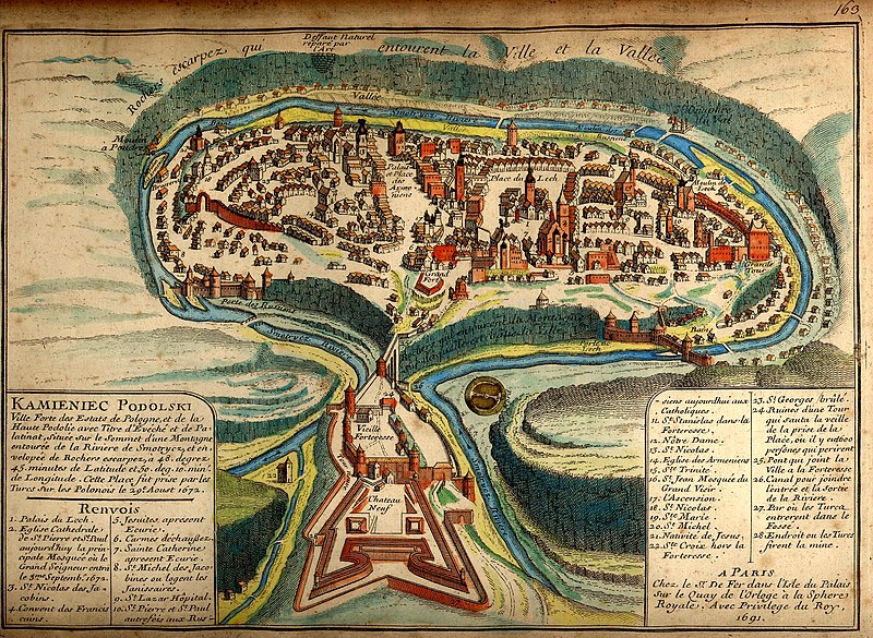
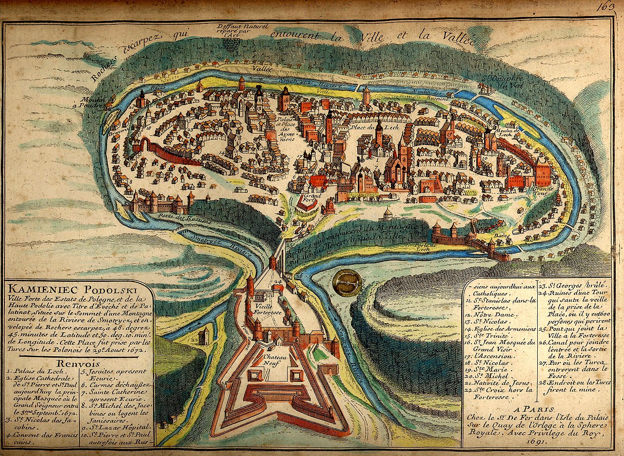
English: An 1691 French map of the city of Kamianets-Podilskyi, located in western Ukraine.
Left-side translation:
Kamieniec Podolski [Kamianets-Podilskyi], the fortified city of the Polish state, and of the high Podolia [Podillia] land, with the title of Bishop and Palatinate, is situated on the top of a mountain surrounded by the Smotrycz River [Smotrych] and high rocks located on 48 degrees 45 minutes Latitude and 50 deg. 10 min. Longitude. This palace was taken by the Turks of Poland on the 29th of August, 1672.
Right-side translation:
In Paris, on the l'Isle du Palais [Island of the Palace] on the royal portion of the Quay de l’orloge [Orloge Quay], with the royalty's privilege, in 1691.
Українська: Давня французька мапа Кам'янця-Подільського 1691 після його захоплення турками
Русский: Старинная карта Каменца-Подольского 1691 года.
Map legend
Français : KAMIENIEC PODOLSKI
Ville forte des Estats de Pologne, et de la Haute Podolie avec Titre d'Evéché et de Palatinat, située sur le Sommet d’une Montagne entourée de la Riviere de Smotrycz, et envelopée de Rochers escarpez, à 48. degrez 45. minutes de Latitude et 50. deg. 10. min. de Longitude. Cette Place fut prise par les Turcs sur Polonais le 29e Aoust 1672. Renvois
Palais du Lech.
Eglise Cathedrale de St Pierre et St Paul aujourd’huy la principale Mosquée où le Grand Seigneur entra le 3e Septemb. 1672.
St Nicolas des Jacobins.
Convent des Franciscains.
Jesuites apresent Ecurie.
Carmes déchaußez.
Sainte Catherine apresent Ecurie.
St Michel des Jacobines ou logent les Janissaires.
St Lazar Hôpital.
St Pierre et St Paul autrefois aux Russiens aujourdhui aux Catholiques.
St Stanislas dans la Forteresse.
Nôtre Dame.
St Nicolas
Eglise des Armeniens
Ste Trinité.
St Jean Mosquée du Grand Visir.
l’Ascension.
St Nicolas.
Ste Marie.
St Michel.
Nativité de Jesus.
Ste Croix hors la Forteresse.
St Georges /brûlé.
Ruines d’une Tour qui sauta la veille de la prise de la Place, où il y eut 600 perſones qui perirent
Pont qui joint la Ville a la Forteresse
Canal pour joindre l’entrée et la sortie de la Riviere.
Par où les Turcs entrerent dans le Fossé.
Endroit ou les Turcs firent la mine.
A PARIS Chez le Sr De Fer dans l’Isle du Palais sur le Quay de l’Orloge à la Sphere Royale. Avec Privilege du Roy, 1691.
Tarix
Mənbə
brooks-planck.org
Yaradıcı
Nicolas de Fer (–1720)
İzah
French engraver və cartographer
Doğum/ölüm tarixi
1646 / 1647
25 oktyabr 1720
Doğum/ölüm yeri
Paris
Paris
Yaradıcılıq məkanı
Paris
Normativ yoxlama
: Q1648130
VIAF: 22440072
ISNI: 0000 0000 8342 2495
Open Library: OL2513965A
LCCN: n82147974
GND: 124536794
WorldCat
creator QS:P170,Q1648130
Georeferencing
Georeference the map in Wikimaps Warper If inappropriate please set warp_status = skip to hide.
English: KAMIENIEC PODOLSKI
Fortified city of the Polish State and of Upper Podolia, with the title of bishopric and palatinate [voivodeship], situated on top of a mountain surrounded by the Smotrycz River and enclosed by steep rocks, at 48°45’ latitude and 50°10’ longitude. This place was taken by the Turks from the Poles on 29 August 1672.
References
Lech’s Palace
Cathedral church of St Peter and St Paul, today the main mosque where the Grand Vizier entered on 3 September 1672
St Nicholas’ [church] of the Dominicans
Franciscan monastery
Jesuits’ [church], now a stable
Discalced Carmelites’ [church]
St Catherine’s [church], now a stable
Jesuits’ [church] of St Michael where the janissaries are quartered
St Lazarus Hospital
St Peter’s and St Paul’s [church], previously Ruthenian [Orthodox], today Catholic
St Stanislaus’ [church] in the fortress
Our Lady’s [church]
St Nicholas’ [church]
Armenian [Orthodox] church
Holy Trinity [church]
St John’s [church, now] Grand Vizier’s mosque
Ascension [church]
St Nicholas’ [church]
St Mary’s [church]
St Michael’s [church]
Nativity [church]
Holy Cross [church] outside the fortress
St George’s [church], burnt
Ruins of a tower which collapsed on the eve of the city’s capture, where 600 people perished
Bridge linking the city with the fortress
Canal linking the inlet and the outlet of the river
[Place] where the Turks entered the moat
Place where the Turks planted a mine
[Made] in Paris At Mr. [Nicolas] De Fer’s [workshop] on the Palace Island on the Clock Quay at the Royal Sphere. With royal privilege, 1691.
Full text of the legend
Annotations
InfoField
This image is annotated: View the annotations at Commons
20
1040
544
269
2296
1680
Français : KAMIENIEC PODOLSKI Ville forte des Estats de Pologne, et de la Haute Podolie avec Titre d'Evéché et de Palatinat, située sur le Sommet d’une Montagne entourée de la Riviere de Smotrycz, et envelopée de Rochers escarpez, à 48. degrez 45. minutes de Latitude et 50. deg. 10. min. de Longitude. Cette Place fut prise par les Turcs sur Polonais le 29e Aoust 1672.
English: KAMIENIEC PODOLSKI Fortified city of the Polish State and of Upper Podolia, with the title of bishopric and palatinate [voivodeship], situated on top of a mountain surrounded by the Smotrycz River and enclosed by steep rocks, at 48°45’ latitude and 50°10’ longitude. This place was taken by the Turks from the Poles on 29 August 1672.
1706
1479
551
169
2296
1680
Français : A PARIS Chez le Sr De Fer dans l’Isle du Palais sur le Quay de l’Orloge à la Sphere Royale. Avec Privilege du Roy, 1691.
English: [Made] in Paris At Mr. [Nicolas] De Fer’s [workshop] on the Palace Island on the Clock Quay at the Royal Sphere. With royal privilege, 1691.
16
1318
547
328
2296
1680
English: References
Lech’s Palace
Cathedral church of St Peter and St Paul, today the main mosque where the Grand Vizier entered on 3 September 1672
St Nicholas’ [church] of the Dominicans
Franciscan monastery
Jesuits’ [church], now a stable
Discalced Carmelites’ [church]
St Catherine’s [church], now a stable
Jesuits’ [church] of St Michael where the janissaries are quartered
St Lazarus Hospital
St Peter’s and St Paul’s [church], previously Ruthenian [Orthodox], today Catholic
1704
1020
549
457
2296
1680
English: 11. St Stanislaus’ [church] in the fortress
12. Our Lady’s [church] 13. St Nicholas’ [church] 14. Armenian [Orthodox] church 15. Holy Trinity [church] 16. St John’s [church, now] Grand Vizier’s mosque 17. Ascension [church] 18. St Nicholas’ [church] 19. St Mary’s [church] 20. St Michael’s [church] 21. Nativity [church] 22. Holy Cross [church] outside the fortress 23. St George’s [church], burnt 24. Ruins of a tower which collapsed on the eve of the city’s capture, where 600 people perished 25. Bridge linking the city with the fortress 26. Canal linking the inlet and the outlet of the river 27. [Place] where the Turks entered the moat
28. Place where the Turks planted a mine
Lisenziya
Public domainPublic domainfalsefalse
https://creativecommons.org/publicdomain/mark/1.0/PDMCreative Commons Public Domain Mark 1.0falsefalse
Assessment
This is a featured picture on the ingilis language Wikipedia (Featured pictures) and is considered one of the finest images. This is a featured picture on the türk language Wikipedia (Seçkin resimler) and is considered one of the finest images.
If you think this file should be featured on Wikimedia Commons as well, feel free to nominate it. If you have an image of similar quality that can be published under a suitable copyright license, be sure to upload it, tag it, and nominate it.
This English Wikipedia featured picture is fairly large and has an aspect ratio of approximately 4:3 or 5:4, making it suitable as a computer wallpaper.
See the gallery of such images, or the gallery of widescreen images.
Captions
Add a one-line explanation of what this file represents
Items portrayed in this file
təsvir edir
MIME type ingilis
image/jpeg
Faylın tarixçəsi
Faylın əvvəlki versiyasını görmək üçün gün/tarix bölməsindəki tarixlərə klikləyin.
{{Information |Description={{en|An 1691 map of the Ukrainian City of Kamianets-Podilskyi.}} {{ru|Старинная карта Каменца-Подольского 1691 года}} |Source=[[:ru:Изображени
Bu faylda fotoaparat və ya skanerlə əlavə olunmuş məlumatlar var. Əgər fayl sonradan redaktə olunubsa, bəzi parametrlər bu şəkildə göstərilənlərdən fərqli ola bilər.
_error
0
Dekabr 31, 2022
fayl, kamianets, podilskyi, 1691, fayl, faylın, tarixçəsi, istifadə, edilən, səhifələr, faylın, qlobal, istifadəsi, metaməlumatlarsınaq, göstərişi, ölçüsü, piksel, digər, ölçülər, piksel, piksel, piksel, piksel, piksel, faylın, orijinalı, 8206, piksel, fayl, h. Fayl Faylin tarixcesi Istifade edilen sehifeler Faylin qlobal istifadesi MetamelumatlarSinaq gosterisi olcusu 800 585 piksel Diger olculer 320 234 piksel 640 468 piksel 1 024 749 piksel 1 280 937 piksel 2 296 1 680 piksel Faylin orijinali 8206 2 296 1 680 piksel fayl hecmi 1 58 MB MIME novu image jpeg Bu fayl Vikimedia Commons dadirve diger layihelerde istifade edile biler Faylin tesvir sehifesine get Mundericat 1 Xulase 2 Full text of the legend 3 Lisenziya 4 Assessment Xulase DescriptionKamianets Podilskyi map 1691 jpg English An 1691 French map of the city of Kamianets Podilskyi located in western Ukraine Left side translation Kamieniec Podolski Kamianets Podilskyi the fortified city of the Polish state and of the high Podolia Podillia land with the title of Bishop and Palatinate is situated on the top of a mountain surrounded by the Smotrycz River Smotrych and high rocks located on 48 degrees 45 minutes Latitude and 50 deg 10 min Longitude This palace was taken by the Turks of Poland on the 29th of August 1672 dd Right side translation In Paris on the l Isle du Palais Island of the Palace on the royal portion of the Quay de l orloge Orloge Quay with the royalty s privilege in 1691 dd Ukrayinska Davnya francuzka mapa Kam yancya Podilskogo 1691 pislya jogo zahoplennya turkami Russkij Starinnaya karta Kamenca Podolskogo 1691 goda Map legend Francais KAMIENIEC PODOLSKI Ville forte des Estats de Pologne et de la Haute Podolie avec Titre d Eveche et de Palatinat situee sur le Sommet d une Montagne entouree de la Riviere de Smotrycz et envelopee de Rochers escarpez a 48 degrez 45 minutes de Latitude et 50 deg 10 min de Longitude Cette Place fut prise par les Turcs sur Polonais le 29e Aoust 1672 Renvois Palais du Lech Eglise Cathedrale de St Pierre et St Paul aujourd huy la principale Mosquee ou le Grand Seigneur entra le 3e Septemb 1672 St Nicolas des Jacobins Convent des Franciscains Jesuites apresent Ecurie Carmes dechaussez Sainte Catherine apresent Ecurie St Michel des Jacobines ou logent les Janissaires St Lazar Hopital St Pierre et St Paul autrefois aux Russiens aujourdhui aux Catholiques St Stanislas dans la Forteresse Notre Dame St Nicolas Eglise des Armeniens Ste Trinite St Jean Mosquee du Grand Visir l Ascension St Nicolas Ste Marie St Michel Nativite de Jesus Ste Croix hors la Forteresse St Georges brule Ruines d une Tour qui sauta la veille de la prise de la Place ou il y eut 600 perſones qui perirent Pont qui joint la Ville a la Forteresse Canal pour joindre l entree et la sortie de la Riviere Par ou les Turcs entrerent dans le Fosse Endroit ou les Turcs firent la mine A PARIS Chez le Sr De Fer dans l Isle du Palais sur le Quay de l Orloge a la Sphere Royale Avec Privilege du Roy 1691 Tarix 1691Menbe brooks planck orgYaradici Nicolas de Fer 1720 Izah French engraver ve cartographerDogum olum tarixi 1646 1647 25 oktyabr 1720 Dogum olum yeri ParisParisYaradiciliq mekani Paris Normativ yoxlama Q1648130 VIAF 22440072 ISNI 0000 0000 8342 2495 Open Library OL2513965A LCCN n82147974 GND 124536794 WorldCat creator QS P170 Q1648130Georeferencing Georeference the map in Wikimaps Warper If inappropriate please set warp status skip to hide English KAMIENIEC PODOLSKI Fortified city of the Polish State and of Upper Podolia with the title of bishopric and palatinate voivodeship situated on top of a mountain surrounded by the Smotrycz River and enclosed by steep rocks at 48 45 latitude and 50 10 longitude This place was taken by the Turks from the Poles on 29 August 1672 References Lech s Palace Cathedral church of St Peter and St Paul today the main mosque where the Grand Vizier entered on 3 September 1672 St Nicholas church of the Dominicans Franciscan monastery Jesuits church now a stable Discalced Carmelites church St Catherine s church now a stable Jesuits church of St Michael where the janissaries are quartered St Lazarus Hospital St Peter s and St Paul s church previously Ruthenian Orthodox today Catholic St Stanislaus church in the fortress Our Lady s church St Nicholas church Armenian Orthodox church Holy Trinity church St John s church now Grand Vizier s mosque Ascension church St Nicholas church St Mary s church St Michael s church Nativity church Holy Cross church outside the fortress St George s church burnt Ruins of a tower which collapsed on the eve of the city s capture where 600 people perished Bridge linking the city with the fortress Canal linking the inlet and the outlet of the river Place where the Turks entered the moat Place where the Turks planted a mine Made in Paris At Mr Nicolas De Fer s workshop on the Palace Island on the Clock Quay at the Royal Sphere With royal privilege 1691 Full text of the legend AnnotationsInfoFieldThis image is annotated View the annotations at Commons20 1040 544 269 2296 1680 Francais KAMIENIEC PODOLSKI Ville forte des Estats de Pologne et de la Haute Podolie avec Titre d Eveche et de Palatinat situee sur le Sommet d une Montagne entouree de la Riviere de Smotrycz et envelopee de Rochers escarpez a 48 degrez 45 minutes de Latitude et 50 deg 10 min de Longitude Cette Place fut prise par les Turcs sur Polonais le 29e Aoust 1672 English KAMIENIEC PODOLSKI Fortified city of the Polish State and of Upper Podolia with the title of bishopric and palatinate voivodeship situated on top of a mountain surrounded by the Smotrycz River and enclosed by steep rocks at 48 45 latitude and 50 10 longitude This place was taken by the Turks from the Poles on 29 August 1672 1706 1479 551 169 2296 1680 Francais A PARISChez le Sr De Fer dans l Isle du Palais sur le Quay de l Orloge a la Sphere Royale Avec Privilege du Roy 1691 English Made in Paris At Mr Nicolas De Fer s workshop on the Palace Island on the Clock Quay at the Royal Sphere With royal privilege 1691 16 1318 547 328 2296 1680 English References Lech s Palace Cathedral church of St Peter and St Paul today the main mosque where the Grand Vizier entered on 3 September 1672 St Nicholas church of the Dominicans Franciscan monastery Jesuits church now a stable Discalced Carmelites church St Catherine s church now a stable Jesuits church of St Michael where the janissaries are quartered St Lazarus Hospital St Peter s and St Paul s church previously Ruthenian Orthodox today Catholic 1704 1020 549 457 2296 1680 English 11 St Stanislaus church in the fortress12 Our Lady s church 13 St Nicholas church 14 Armenian Orthodox church 15 Holy Trinity church 16 St John s church now Grand Vizier s mosque 17 Ascension church 18 St Nicholas church 19 St Mary s church 20 St Michael s church 21 Nativity church 22 Holy Cross church outside the fortress 23 St George s church burnt 24 Ruins of a tower which collapsed on the eve of the city s capture where 600 people perished 25 Bridge linking the city with the fortress 26 Canal linking the inlet and the outlet of the river 27 Place where the Turks entered the moat 28 Place where the Turks planted a mine Lisenziya Public domain Public domain false falseThis work is in the public domain in its country of origin and other countries and areas where the copyright term is the author s life plus 100 years or fewer You must also include a United States public domain tag to indicate why this work is in the public domain in the United States This file has been identified as being free of known restrictions under copyright law including all related and neighboring rights https creativecommons org publicdomain mark 1 0 PDM Creative Commons Public Domain Mark 1 0 false falseAssessment This is a featured picture on the ingilis language Wikipedia Featured pictures and is considered one of the finest images This is a featured picture on the turk language Wikipedia Seckin resimler and is considered one of the finest images If you think this file should be featured on Wikimedia Commons as well feel free to nominate it If you have an image of similar quality that can be published under a suitable copyright license be sure to upload it tag it and nominate it This English Wikipedia featured picture is fairly large and has an aspect ratio of approximately 4 3 or 5 4 making it suitable as a computer wallpaper See the gallery of such images or the gallery of widescreen images CaptionsazerbaycancaAdd a one line explanation of what this file representsItems portrayed in this filetesvir edirMIME type ingilisimage jpeg Faylin tarixcesi Faylin evvelki versiyasini gormek ucun gun tarix bolmesindeki tarixlere klikleyin Tarix VaxtKicik sekilOlculerIstifadeciSerh indiki23 29 18 oktyabr 20072 296 1 680 1 58 MB DDima Information Description en An 1691 map of the Ukrainian City of Kamianets Podilskyi ru Starinnaya karta Kamenca Podolskogo 1691 goda Source ru Izobrazheni Istifade edilen sehifeler Bu sekile olan kecidler Osmanli Muqeddes Ittifaq muharibesi Faylin qlobal istifadesi Bu fayl asagidaki vikilerde istifade olunur ast wikipedia org layihesinde istifadesi Kamianets Podilskyi be wikipedia org layihesinde istifadesi Kamyanec Padolski zamak bg wikipedia org layihesinde istifadesi Kamenec Podolski Kamenec Podolska krepost Star grad Kamenec Podolski ca wikipedia org layihesinde istifadesi Kamianets Podilski de wikipedia org layihesinde istifadesi Kamjanez Podilskyj Hekling Armenische Diaspora in Europa dsb wikipedia org layihesinde istifadesi Republika Dweju Narodowu Podolske wojwodstwo el wikipedia org layihesinde istifadesi Egialeti ths Podolias en wikipedia org layihesinde istifadesi Wikipedia WikiProject Former countries Kamianets Podilskyi Portal Ukraine Portal Ukraine Featured picture Portal talk Ukraine Featured picture Wikipedia WikiProject Poland User Sashazlv Try Portal History Featured picture Wikipedia WikiProject Urban studies and planning Portal Maps Selected picture Wikipedia Featured pictures thumbs 08 Wikipedia WikiProject Ukraine User talk DDima Archive 3 Wikipedia Featured picture candidates Kamianets Podilskyi map Wikipedia Wikipedia Signpost 2007 11 05 Features and admins Wikipedia Featured picture candidates November 2007 Portal Maps Selected picture 30 Wikipedia Picture of the day March 2008 Kamianets Podilskyi Castle Template POTD 2008 03 09 Wikipedia Featured pictures Diagrams drawings and maps Maps Portal Russia Selected picture 11 Wikipedia Wikipedia Signpost 2007 11 05 SPV User Amitchell125 Podolia Eyalet Royal city in Polish Lithuanian Commonwealth Portal Poland Recognized content Portal Ukraine Recognized content en wikivoyage org layihesinde istifadesi Kamianets Podilskyi es wikipedia org layihesinde istifadesi Kamianets Podilski Eyalato de Podolia fr wikipedia org layihesinde istifadesi Kamianets Podilskyi Pachalik de Podolie he wikipedia org layihesinde istifadesi איילט פודוליה מבצר קמניץ פודולסקי hr wikipedia org layihesinde istifadesi Kamjanec Podiljskyj hsb wikipedia org layihesinde istifadesi Kamjanec Podilskyj hu wikipedia org layihesinde istifadesi Kamjanec Pogyilszkij Bu faylin qlobal istifadesine baxin Metamelumatlar Bu faylda fotoaparat ve ya skanerle elave olunmus melumatlar var Eger fayl sonradan redakte olunubsa bezi parametrler bu sekilde gosterilenlerden ferqli ola biler error0 Menbe https az wikipedia org wiki Fayl Kamianets Podilskyi map 1691 jpg, wikipedia, oxu, kitab, kitabxana, axtar, tap, hersey,
ne axtarsan burda
, en yaxsi meqale sayti, meqaleler, kitablar, oyrenmek, wiki, bilgi, tarix, seks, porno, indir, yukle, sex, azeri sex, azeri, seks yukle, sex yukle, izle, seks izle, porno izle, mobil seks, telefon ucun, chat, azeri chat, tanisliq, tanishliq, azeri tanishliq, sayt, medeni, medeni saytlar, chatlar, mekan, tanisliq mekani, mekanlari, yüklə, pulsuz, pulsuz yüklə, mp3, video, mp4, 3gp, jpg, jpeg, gif, png, şəkil, muisiqi, mahnı, kino, film, kitab, oyun, oyunlar.