Bu fayl "Vikimedia Commons"dadır və digər layihələrdə istifadə edilə bilər.
Faylın təsvir səhifəsinə get
Xülasə
İzahItaly 1000 AD.svg
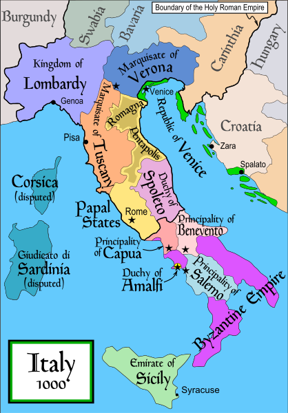
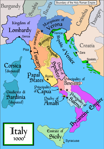
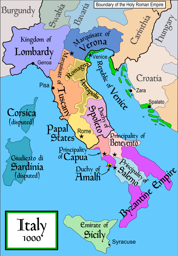
English: Political map of Italy in 1000 AD (CE). Created by MapMaster. Part of a series of maps on the history of Italy:
1084 AD
1494 AD
1796 AD
1810 AD
Tarix
17 noyabr 2006 (original upload date)
Mənbə
No machine-readable source provided. Own work assumed (based on copyright claims).
Müəllif
No machine-readable author provided. MapMaster assumed (based on copyright claims).
Digər versiyalar
[redaktə]
SVG:
català
čeština
Deutsch
English
español
français
Ido
italiano
magyar
polski
português
Türkçe
русский
українська
العربية
עברית
한국어
中文
PNG:
polski
Türkçe
Ελληνικά
中文
This SVG file contains embedded text that can be translated into your language, using any capable SVG editor, text editor or the SVG Translate tool. For more information see: About translating SVG files.
References
Bjorklund, Oddvar; Holmboe, Haakon; Rohr, Anders (1970) Historical Atlas of the World, Barnes & Noble, NY, SBN: 389-00253-4.
This map from Allyn & Bacon, Longman, textbook publishers.
This map of the w:en:Holy Roman Empire
A map from Attilios
This map of 1050 AD Italy, from the 1923 The Historical Atlas by William R. Shepherd
This map of 1000 AD Italy from Fordham University, adapted from Muir's Historical Atlas, (1911).
In addition, a number of other sources were consulted in an effort to determine the following matters:
The extent of Venetian control over the cities of Dalmatia such as Zara and Spalato. Although the Venetians had been pushed off the mainland earlier, in the period around the year 1000, the Venetians made an effort to recover these cities.
The extent of Saracen control over Corsica and Sardinia. Information is sparse. The apparent situation is that the Muslims had several bases on the coasts of these islands, but did not control the countryside (such as they did in Sicily).
Whether or not the principalities of Capua and Benevento were separate states in the year 1000. Based on lists of their rulers (various Pandulfs and Landulfs), the answer seems to be "yes".
Who controlled the Balkans on the southeastern border of the Kingdom of Croatia. Candidates include Bulgaria, the Byzantine Empire, Croatia, and Serbia.
As noted, there is significant disagreement among sources on these questions.
This map was commissioned by Attilios, and there is also a discussion to be found on MapMaster's English talk page.
Lisenziya
I, the copyright holder of this work, hereby publish it under the following license:
Bu sənədi GNU Azad Sənədləşdirmə Lisenziyası, Versiya 1.2 və ya Azad Proqram Fondu tərəfindən nəşr olunan hər hansı sonrakı versiya şərtlərinə əsasən dəyişməz bölmələr, ön qapaq mətnləri və arxa qapaq mətnləri olmadan köçürmək, yayımlamaq və / və ya dəyişdirmək üçün icazə verilir; Lisenziyanın bir nüsxəsi GNU Azad Sənədləşdirmə Lisenziyası adlı hissəyə daxil edilmişdir.http://www.gnu.org/copyleft/fdl.htmlGFDLGNU Free Documentation Licensetruetrue
Bu fayl Creative Commons Attribution-Share Alike 3.0 Sinqapur lisenziyası altında yayımlanır.
Azadsınız:
paylaşmaq – əsəri köçürmək, paylamaq və ötürmək üçün
remiks etmək – əsəri adaptasiya etmək
Aşağıdakı şərtlərə riayət etməklə:
istinad – Müvafiq kredit verməlisiniz, lisenziyaya bir keçid verməlisiniz və dəyişikliklərin olub olmadığını bildirməlisiniz. Bunu hər hansı bir ağlabatan şəkildə edə bilərsiniz, ancaq lisenziyalaşdırıcının sizi və ya istifadənizi təsdiqləməsini təklif edən bir şəkildə deyil.
bənzər paylaşma – Əsəri remix edirsinizsə, dəyişdirirsinizsə və ya üzərində iş aparırsınızsa, öz töhfələrinizi orijinalda olduğu kimi eyni və ya uyğun lisenziya altında yayımlamalısınız.
This licensing tag was added to this file as part of the GFDL licensing update.http://creativecommons.org/licenses/by-sa/3.0/CC BY-SA 3.0Creative Commons Attribution-Share Alike 3.0truetrue
derivative works
Derivative works of this file: Italya MS 1000.svg
Captions
Add a one-line explanation of what this file represents
Items portrayed in this file
təsvir edir
copyright status ingilis
copyrighted ingilis
lisenziya
GNU Free Documentation License, version 1.2 or later ingilis
Creative Commons Attribution-ShareAlike 3.0 Unported ingilis
yaranma tarixi
17 noyabr 2006
MIME type ingilis
image/svg+xml
Faylın tarixçəsi
Faylın əvvəlki versiyasını görmək üçün gün/tarix bölməsindəki tarixlərə klikləyin.
fayl, italy, 1000, fayl, faylın, tarixçəsi, fayl, keçidləri, faylın, qlobal, istifadəsibu, faylın, formatındakı, görünüşünün, ölçüsü, piksel, digər, ölçülər, piksel, piksel, piksel, piksel, piksel, piksel, faylın, orijinalı, 8206, faylı, nominal, olaraq, pikse. Fayl Faylin tarixcesi Fayl kecidleri Faylin qlobal istifadesiBu SVG faylin PNG formatindaki bu gorunusunun olcusu 418 600 piksel Diger olculer 167 240 piksel 334 480 piksel 535 768 piksel 713 1 024 piksel 1 427 2 048 piksel 565 811 piksel Faylin orijinali 8206 SVG fayli nominal olaraq 565 811 piksel faylin olcusu 861 KB Bu fayl Vikimedia Commons dadirve diger layihelerde istifade edile biler Faylin tesvir sehifesine get Mundericat 1 Xulase 2 References 3 Lisenziya 4 derivative works Xulase IzahItaly 1000 AD svg English Political map of Italy in 1000 AD CE Created by MapMaster Part of a series of maps on the history of Italy 1084 AD 1494 AD 1796 AD 1810 AD Tarix 17 noyabr 2006 original upload date Menbe No machine readable source provided Own work assumed based on copyright claims Muellif No machine readable author provided MapMaster assumed based on copyright claims Diger versiyalar redakte SVG catala cestina Deutsch English espanol francais Ido italiano magyar polski portugues Turkce russkij ukrayinska العربية עברית 한국어 中文 PNG polski Turkce Ellhnika 中文 This SVG file contains embedded text that can be translated into your language using any capable SVG editor text editor or the SVG Translate tool For more information see About translating SVG files References Bjorklund Oddvar Holmboe Haakon Rohr Anders 1970 Historical Atlas of the World Barnes amp Noble NY SBN 389 00253 4 This map from Allyn amp Bacon Longman textbook publishers This map of the w en Holy Roman Empire A map from Attilios This map of 1050 AD Italy from the 1923 The Historical Atlas by William R Shepherd This map of 1000 AD Italy from Fordham University adapted from Muir s Historical Atlas 1911 In addition a number of other sources were consulted in an effort to determine the following matters The extent of Venetian control over the cities of Dalmatia such as Zara and Spalato Although the Venetians had been pushed off the mainland earlier in the period around the year 1000 the Venetians made an effort to recover these cities The extent of Saracen control over Corsica and Sardinia Information is sparse The apparent situation is that the Muslims had several bases on the coasts of these islands but did not control the countryside such as they did in Sicily Whether or not the principalities of Capua and Benevento were separate states in the year 1000 Based on lists of their rulers various Pandulfs and Landulfs the answer seems to be yes Who controlled the Balkans on the southeastern border of the Kingdom of Croatia Candidates include Bulgaria the Byzantine Empire Croatia and Serbia As noted there is significant disagreement among sources on these questions This map was commissioned by Attilios and there is also a discussion to be found on MapMaster s English talk page Lisenziya I the copyright holder of this work hereby publish it under the following license Bu senedi GNU Azad Senedlesdirme Lisenziyasi Versiya 1 2 ve ya Azad Proqram Fondu terefinden nesr olunan her hansi sonraki versiya sertlerine esasen deyismez bolmeler on qapaq metnleri ve arxa qapaq metnleri olmadan kocurmek yayimlamaq ve ve ya deyisdirmek ucun icaze verilir Lisenziyanin bir nusxesi GNU Azad Senedlesdirme Lisenziyasi adli hisseye daxil edilmisdir http www gnu org copyleft fdl html GFDL GNU Free Documentation License true true Bu fayl Creative Commons Attribution Share Alike 3 0 Sinqapur lisenziyasi altinda yayimlanir Azadsiniz paylasmaq eseri kocurmek paylamaq ve oturmek ucun remiks etmek eseri adaptasiya etmek Asagidaki sertlere riayet etmekle istinad Muvafiq kredit vermelisiniz lisenziyaya bir kecid vermelisiniz ve deyisikliklerin olub olmadigini bildirmelisiniz Bunu her hansi bir aglabatan sekilde ede bilersiniz ancaq lisenziyalasdiricinin sizi ve ya istifadenizi tesdiqlemesini teklif eden bir sekilde deyil benzer paylasma Eseri remix edirsinizse deyisdirirsinizse ve ya uzerinde is aparirsinizsa oz tohfelerinizi orijinalda oldugu kimi eyni ve ya uygun lisenziya altinda yayimlamalisiniz This licensing tag was added to this file as part of the GFDL licensing update http creativecommons org licenses by sa 3 0 CC BY SA 3 0 Creative Commons Attribution Share Alike 3 0 true true derivative works Derivative works of this file nbsp Italya MS 1000 svgCaptionsazerbaycancaAdd a one line explanation of what this file representsItems portrayed in this filetesvir edircopyright status nbsp ingiliscopyrighted nbsp ingilislisenziyaGNU Free Documentation License version 1 2 or later nbsp ingilisCreative Commons Attribution ShareAlike 3 0 Unported nbsp ingilisyaranma tarixi17 noyabr 2006MIME type nbsp ingilisimage svg xml Faylin tarixcesi Faylin evvelki versiyasini gormek ucun gun tarix bolmesindeki tarixlere klikleyin Tarix VaxtKicik sekilOlculerIstifadeciSerh indiki19 50 17 aprel 2007565 811 861 KB MapMasterSome further changes 05 10 19 fevral 2007565 811 824 KB MapMasterchanges to ensure consistency with my other Italy maps 05 39 25 noyabr 2006565 811 823 KB MapMasterImproved map 14 44 18 noyabr 2006565 811 827 KB MapMasterImproved I hope version based on recommendations from Attilios 21 50 17 noyabr 2006565 811 768 KB MapMasterPolitical map of Italy in 1000 AD CE Fayl kecidleri Bu sekile olan kecidler Amalfi Respublikasi Siciliya emirliyi Faylin qlobal istifadesi Bu fayl asagidaki vikilerde istifade olunur an wikipedia org layihesinde istifadesi Republica de Pisa ar wikipedia org layihesinde istifadesi ويكيبيديا ورشة الصور أرشيف 4 ast wikipedia org layihesinde istifadesi Republica amalfitana azb wikipedia org layihesinde istifadesi سالرنو سیسیل امیرلیغی bg wikipedia org layihesinde istifadesi Romuald II Benevento Knyazhestvo Kapua Hercogstvo Amalfi Spisk na princovete na Salerno Sicilijski emirat bn wikipedia org layihesinde istifadesi আম র ত দক ষ ণ ইত ল ত ইসল ম র ইত হ স স স ল আম র ত bs wikipedia org layihesinde istifadesi Sicilijski emirat cs wikipedia org layihesinde istifadesi Italie Italske historicke staty Veronske markrabstvi da wikipedia org layihesinde istifadesi Hertuger og prinser af Benevento Basil Boioannes Normanniske erobring af Syditalien de wikipedia org layihesinde istifadesi Diskussion Bulgarien Archiv 1 Wikipedia Kartenwerkstatt Archiv 2007 12 el wikipedia org layihesinde istifadesi Lombardoi Mpenebento Goyaimaros D toy Salerno Katalogos istorikwn kratwn ths Italias Katalogos prigkipwn toy Salerno Katalogos doykwn kai prigkipwn toy Mpenebento Katalogos prigkipwn ths Kapoya en wikipedia org layihesinde istifadesi Lombards Pope Stephen IX Otto III Holy Roman Emperor Otto II Holy Roman Emperor Salerno Benevento Emirate List of historic states of Italy List of state leaders in the 10th century Duchy of Spoleto Duchy of Benevento Kalbids Guaimar IV of Salerno Rainulf Drengot Duchy of Amalfi Emirate of Sicily Sergius IV of Naples List of princes of Capua List of princes of Salerno Principality of Capua User MapMaster Bu faylin qlobal istifadesine baxin Menbe https az wikipedia org wiki Fayl Italy 1000 AD svg, wikipedia, oxu, kitab, kitabxana, axtar, tap, hersey,
ne axtarsan burda
, en yaxsi meqale sayti, meqaleler, kitablar, oyrenmek, wiki, bilgi, tarix, seks, porno, indir, yukle, sex, azeri sex, azeri, seks yukle, sex yukle, izle, seks izle, porno izle, mobil seks, telefon ucun, chat, azeri chat, tanisliq, tanishliq, azeri tanishliq, sayt, medeni, medeni saytlar, chatlar, mekan, tanisliq mekani, mekanlari, yüklə, pulsuz, pulsuz yüklə, mp3, video, mp4, 3gp, jpg, jpeg, gif, png, şəkil, muisiqi, mahnı, kino, film, kitab, oyun, oyunlar.